 Catalogue PIGMA
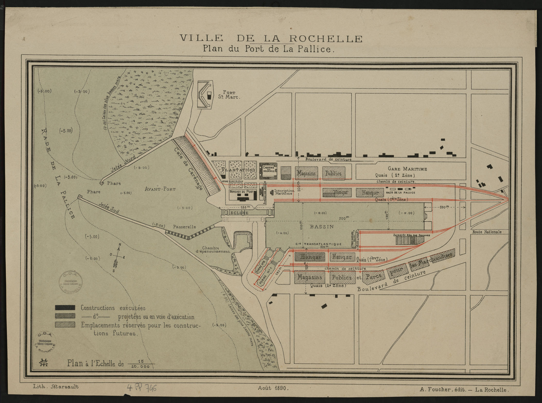
Plan du port de la Pallice en 1890_4PL746
Thème :
Date.edition :
Auteur.nom :
Auteur.date :
Interêt : 1890. Plan détaillé de la Pallice en couleur avec gare et 2 bassins. Entrepôts et parcs à marchandises.
Editeur : A. Foucher
Echelle :
Taille :
Lieu d'archivage : Michel Crépeau, Patrimoine, Reserve A 4 PL 746. Exclu du prêt, consultation sur place
Numéro d'archive : Plan Carte (No )
Indices :
Référence : 4 PL 746
Simple
- Date (Creation)
- 2016-09-05
- Date (Publication)
- 2017-01-30
- Date (Revision)
- 2017-01-30
- Identifier
- FR-180-089-013-03720-LIENSs_dypomar_4_PL_746_20161229
- Credit
- LIttoral ENvironnement et Sociétés - La Rochelle Université / CNRS
- GEMET - INSPIRE themes, version 1.0
-
- Régions maritimes
- Keywords
-
- La Rochelle, Port de la Pallice, Bassin Transatlantique, Chambre d'épanouissement, Jetée sud, Jetée nord
- Use limitation
- Utilisation libre sous réserve de mentionner la source (a minima le nom du producteur) et la date de sa dernière mise à jour.
- Access constraints
- Intellectual property rights
- Access constraints
- Other restrictions
- Other constraints
- Pas de restriction d’accès publique
- Classification
- Unclassified
- Spatial representation type
- grid Grid
- Metadata language
- Français
- Character set
- utf8 UTF8
- Topic category
-
- Imagery base maps earth cover
- Society
- Environment
))
))
))
- Begin date
- 1890-01-01
- End date
- 1890-01-01
- Reference system identifier
- EPSG / Lambert 93 / 7.4
- Reference system identifier
- INSPIRE RS registry / grégorien
- Distribution format
-
-
GeoTIFF
(
)
-
GeoTIFF
(
)
- OnLine resource
-
pyramid_1890
(
OGC:WMS
)
pyramid_1890
- Hierarchy level
- Dataset
- Statement
-
Carte réf. 4 PL 746 fournie par la Médiathèque d’agglomération de La Rochelle en format numérique.
Géoréférencer le 05/09/2016 par N. Volto du LIENSs (8 points, transformation du 1er ordre, affine, avec le logiciel Arcgis (ESRI) version 10.3.1).
- File identifier
- ee1bb2c8-07ab-48be-be97-bab1e8cd75db XML
- Metadata language
- Français
- Character set
- UTF8
- Hierarchy level
- Dataset
- Hierarchy level name
- Série de données
- Date stamp
- 2025-05-16T09:28:44.931678Z
- Metadata standard name
- ISO 19115-3 - SEXTANT
- Metadata standard version
- 1.0
Overviews
Spatial extent
Provided by
