 Catalogue PIGMA
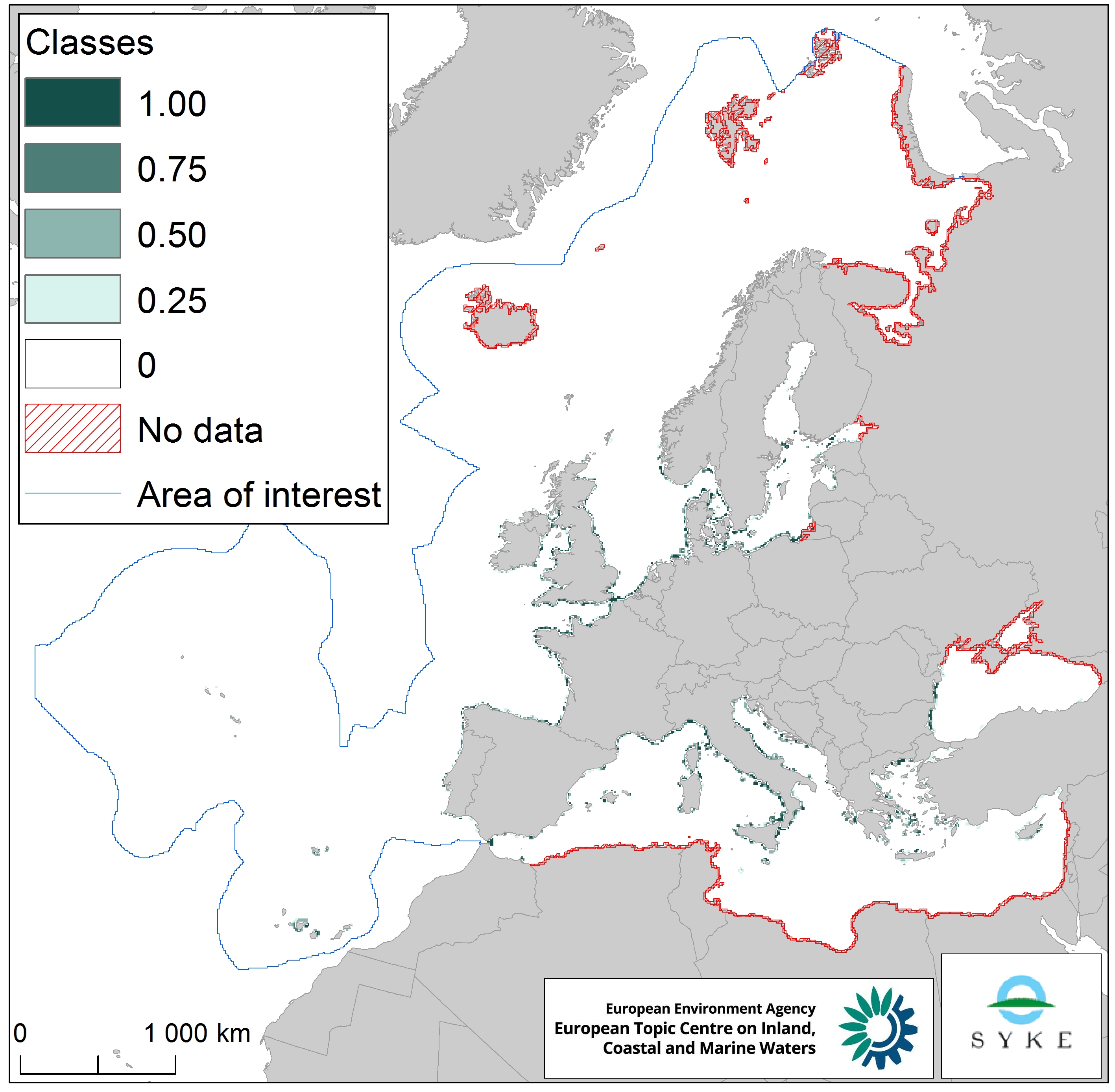
Input of microbial pathogens along European coastlines, Jan. 2020
This raster dataset represents the input of microbial pathogens along the European coastlines.
The pressure layer was created using three different datasets rasterized using the EEA 10 km grid: urban agglomerations reported under the Urban Waste Water Treatment Directive (2017), EMODnet dataset of ports lying on the sea coast together with passenger information (annual average 2006-2016) and Intestinal enterococci and Escherichia coli data at bathing sites as measured under the Bathing Water Directive reporting obligation (average 2008-2016). All three datasets were then classified into four classes, aggregated and classified again (quantile classes between 0 and 1, with the latter being the highest pathogen pressure).
This dataset has been prepared for the calculation of the combined effect index, produced for the ETC/ICM Report 4/2019 "Multiple pressures and their combined effects in Europe's seas" available on: https://www.eionet.europa.eu/etcs/etc-icm/etc-icm-report-4-2019-multiple-pressures-and-their-combined-effects-in-europes-seas-1.
Simple
- Date (Creation)
- 2018-09-01
- Date (Publication)
- 2020-01-27
- Edition
- 01.00
- Identifier
- eea_r_3035_10_km_pathogens-coastlines_p_2006-2016_v01_r00
Point of contact
- Maintenance and update frequency
- As needed
- Keywords
-
- Keywords
-
- GEMET
-
- bathing water
- passenger transport
- sea
- pressure
- pathogen
- water quality
- coast
- urban waste water treatment
- Urban Waste Water Treatment Directive
- harbour
- bathing water directive
- maritime transport
- environmental pressure
- Continents, countries, sea regions of the world.
-
- English Channel
- Celtic Sea
- Ionian Sea
- North Sea
- Barents Sea
- Kattegat
- Northeast Atlantic Ocean (40W)
- Baltic Sea
- Bay of Biscay
- Black Sea
- Mediterranean Sea
- Adriatic Sea
- Norwegian Sea
- Iceland Sea
- Spatial scope
-
- European
- EEA topics
-
- Biodiversity
- Waste and recycling
- Human health impacts
- Seas and coasts
- Bathing water quality
- Sous-regions marines
-
- /Métropole
- /Métropole/Manche mer du Nord
- /Métropole/Mers Celtiques
- /Métropole/Golfe de Gascogne
- /Métropole/Méditerranée occidentale
- Thématiques - SIMM
-
- /Activités et Usages/Transport maritime et Ports
- Thématiques - SIMM
-
- /Activités et Usages/Urbanisation et Artificialisation
- Thématiques - SIMM
-
- /Etat du Milieu/Pollutions
- Type de jeux de donnée - ODATIS
-
- /Données dérivées/Indicateurs
- Type de jeux de donnée - ODATIS
-
- /Données dérivées/Produits composites
- Cadre Réglementaire - SIMM
-
- Directive Eaux de baignade
- Access constraints
- Other restrictions
- Other constraints
- no limitations to public access
- Use constraints
- Other restrictions
- Other constraints
- License CC-BY 4.0 (https://creativecommons.org/licenses/by/4.0/). Copyright holder: European Environment Agency (EEA).
- Spatial representation type
- grid Grid
- Distance
- 10 km
- Metadata language
- English
- Topic category
-
- Environment
- Oceans
- Health
))
- Begin date
- 2006-01-01
- End date
- 2016-12-31
- Unique resource identifier
- EPSG:3035
- Distribution format
-
-
GeoTIFF
(
)
-
GeoTIFF
(
)
- OnLine resource
- https://sdi.eea.europa.eu/webdav/datastore/public/eea_r_3035_10_km_pathogens-coastlines_p_2006-2016_v01_r00/ ( EEA:FOLDERPATH )
- OnLine resource
- Direct download ( WWW:URL )
- OnLine resource
- https://water.discomap.eea.europa.eu/arcgis/rest/services/Marine/Pressures_Microbial_pathogens/MapServer ( ESRI:REST )
- Hierarchy level
- Dataset
Domain consistency
Conformance result
- Date (Publication)
- 2010-12-08
- Explanation
- See the referenced specification
- Statement
-
The pressure layer was created using three different datasets converted to the EEA 10 km grid:
1. Urban agglomerations reported under the Urban Waste Water Treatment Directive (UWWTD)
2. EMODnet dataset of ports with passenger information
3. Intestinal enterococci and Escherichia coli at bathing sites as measured under the Bathing Waters Directive reporting obligations.
Urban agglomerations (reported under UWWTD) laying no further than 5 km from the coast were identified and compiled in a common layer. Only agglomerations with more than 5% untreated waste were selected. The information of load (PE) generated by specific agglomerations was kept. Pressure data was extrapolated to the neighbouring cells using 2 buffer belts (6 km-30% reduction) and 12 km-60% reduction.
All ports (EMODnet) lying on the sea coast were selected. Information on number of passengers (annual average 2006-2016) was also obtained, which can be used as proxy for pressure intensity. Pressure data was extrapolated to the neighbouring cells using buffer belts (6 km-30% reduction) and 12 km-60% reduction. More information on https://www.emodnet.eu/geonetwork/emodnet/spa/catalog.search?node=emodnet#/metadata/c0c12986-4373-4cef-a1a4-75db11a4eafd.
Intestinal enterococci and Escherichia coli data at bathing sites (as measured under the Bathing Water Directive reporting obligation, average 2008-2016) was extrapolated to the neighbouring cells using 5 km buffer belt (50% reduction).
The three datasets were classified into quantiles (with the values 0.25/0.5/0.75/1.00 representing the quantiles, and 1.00 being the highest pathogen pressure) and then combined into a single pressure layer. Where the datasets overlapped, the cell was assigned the largest (maximum) value.
- File identifier
- f7fb5360-e8e6-4a98-852c-3f56f96a361c XML
- Metadata language
- English
- Character set
- UTF8
- Hierarchy level
- Dataset
- Date stamp
- 2025-10-09T11:23:51.925465Z
- Metadata standard name
- ISO 19115/19139
- Metadata standard version
- 1.0
Overviews
Spatial extent
Provided by
