 Catalogue PIGMA
/Ocean Chemistry/Chlorophyll
Type of resources
Topics
Keywords
Contact for the resource
Provided by
Years
Formats
Representation types
status
-

The primary objective of the ESA Marine Atmosphere eXtreme Satellite Synergy (MAXSS) project is to provide guidance and innovative methodologies to maximize the synergetic use of available Earth Observation data (satellite, in situ) to improve understanding about the multi-scale dynamical characteristics of extreme air-sea interaction. This dataset, produced in the frame of MAXSS project, provides multi-variate observations for tropical cyclones (TC), for a selection of storm tracks from the International Best Track Archive for Climate Stewardship (IBTrACS) during the period 2010-2020. The observations are taken from more than 35 satellite, numerical model and in situ sources, providing the inner and surface ocean conditions for a comprehensive range of parameters (sea surface height, surface winds, waves, precipitation, temperature, salinity, ocean colour, ...) before, during and after the storm passage. Different colocation radii and time windows are used depending on the parameter and observation dataset. The assembled data are stored in a standardized NetCDF4 file format and organised per basin, year, and storm name to ease data manipulation for users that are not used to work with this wealth of data.
-

The primary objective of the ESA Marine Atmosphere eXtreme Satellite Synergy (MAXSS) project is to provide guidance and innovative methodologies to maximize the synergetic use of available Earth Observation data (satellite, in situ) to improve understanding about the multi-scale dynamical characteristics of extreme air-sea interaction. This dataset, produced in the frame of MAXSS project, provides multi-variate observations for extra-tropical cyclones (ETC), for a selection of storm tracks extracted from the wind vorticity at 850mb of ERA5 reanalysis during the period 2010-2020. The observations are taken from more than 35 satellite, numerical model and in situ sources, providing the inner and surface ocean conditions for a comprehensive range of parameters (sea surface height, surface winds, waves, precipitation, temperature, salinity, ocean colour, ...) before, during and after the storm passage. Different colocation radii and time windows are used depending on the parameter and observation dataset. The assembled data are stored in a standardized NetCDF4 file format and organised per basin, year, and storm name to ease data manipulation for users that are not used to work with this wealth of data.
-

The primary objective of the ESA Marine Atmosphere eXtreme Satellite Synergy (MAXSS) project is to provide guidance and innovative methodologies to maximize the synergetic use of available Earth Observation data (satellite, in situ) to improve understanding about the multi-scale dynamical characteristics of extreme air-sea interaction. This dataset, produced in the frame of MAXSS project, provides, for a selection of storm tracks from the International Best Track Archive for Climate Stewardship (IBTrACS) during the period 2010-2020, three types of storm-related parameters: (1) the pre-storm upper ocean conditions (e.g., SST, SSS, upper ocean vertical density stratification strength, etc..), (2) the atmospheric forcing during the storm passage (maximum wind, accumulated rain and evaporation, wind power index, etc..) during the storm, as well as (3) the oceanic wakes left after the storm for an ensemble of key variables (SST, SSS, sea level height, ocean color parameters). These quantities are estimated using as input the files from the MAXSS Storm Atlas individual parameter time series which were pre-selected within a fixed radius dX (1000 km for TCs, 1500 kms for ETCs and 500 km fro PLs) around the storm center track and a pre- determined period of time dT around the storm center date of closest passage to . Maps of the estimated 2D pre-storm conditions, atmospheric forcing, and estimated oceanic wakes are generated and saved into a single file for each key ocean wake variable and for each storm together with several mapped parameters characterizing the storm characteristics during its passage (Vmax, Rmax, etc..). The assembled data are stored in a standardized NetCDF4 file format and organised per basin, year, and storm name to ease data manipulation for users that are not used to work with this wealth of data.
-
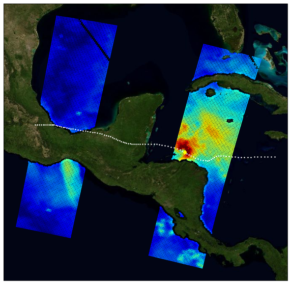
The primary objective of the ESA Marine Atmosphere eXtreme Satellite Synergy (MAXSS) project is to provide guidance and innovative methodologies to maximize the synergetic use of available Earth Observation data (satellite, in situ) to improve understanding about the multi-scale dynamical characteristics of extreme air-sea interaction. This dataset, produced in the frame of MAXSS project, provides multi-variate observations for Arctic polar lows (PL), for a selection of storm tracks extracted from Rojo et al (2019) during the period 2010-2018. The observations are taken from more than 35 satellite, numerical model and in situ sources, providing the inner and surface ocean conditions for a comprehensive range of parameters (sea surface height, surface winds, waves, precipitation, temperature, salinity, ocean colour, ...) before, during and after the storm passage. Different colocation radii and time windows are used depending on the parameter and observation dataset. The assembled data are stored in a standardized NetCDF4 file format and organised per basin, year, and storm name to ease data manipulation for users that are not used to work with this wealth of data.