 Catalogue PIGMA
NetCDF
Type of resources
Available actions
Topics
Keywords
Contact for the resource
Provided by
Years
Formats
Representation types
Update frequencies
status
Scale
Resolution
-

This product contains daily salinity fields over Arctic from a 9 days temporal gaussian average, corrected from land-sea contamination and latitudinal bias, based on L2Q over Arctic products, mixing ascending and descending orbits.
-
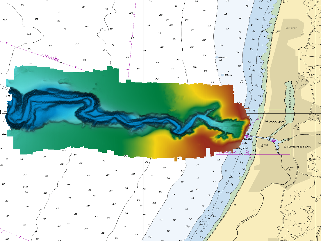
The DTM is a compilation of multibeam echosounder surveys acquired in 2013. The resolution is 1/64 arc-minutes (~30m). Surveys are located on the Capbreton Submarine Canyon (France) with depths from -4.7m to -344.9m. Depths are referenced to the Lowest Astronomical Tide and the coordinates are expressed into the WGS84 reference frame. The surveys which compose the DTM are S201306500-09 and S201306500-11. Data and metadata associated to these surveys are available on the website http://diffusion.shom.fr/pro/lots-bathy.html. The DTM is not to be used for navigation.
-

-

These gridded products are produced from the following upstream data: - for satellites SARAL/AltiKa, Cryosat-2, HaiYang-2B, Jason-3, Copernicus Sentinel-3A/B, Sentinel-6 MF, SWOT Nadir => NRT (Near-Real-Time) Nadir along-track (or Level-3) SEA LEVEL products (DOI: https://doi.org/10.48670/moi-00147) delivered by the Copernicus Marine Service (http://marine.copernicus.eu/ ). The gridded product is based on near-real-time (NRT) Level-3 Nadir datasets for the period from July 7, 2025, to December 31, 2025. => MY (Multi-Year) Nadir along-track (or Level-3) SEA LEVEL products (DOI: https://doi.org/10.48670/moi-00146 ) delivered by the Copernicus Marine Service (CMEMS, http://marine.copernicus.eu/ ). The gridded product is based on MY Level-3 Nadir datasets for the period from March 28, 2023, to July 6, 2025. - for SWOT KaRIn : the L3_LR_SSH Expert v3.0 product distributed by AVISO (DOI: https://doi.org/10.24400/527896/A01-2023.018) from March 28, 2023 to December 31, 2025. One mapping algorithm is proposed: the MIOST approach which provides which provides global Sea Surface Height (SSH) solutions. The MIOST method is capable of accounting for various modes of ocean surface topography variability (e.g., geostrophic, barotropic, equatorial wave dynamics) by constructing multiple independent components within a predefined covariance model.
-

The Sentinel-6 Level-2P skewness products was developed to estimate the skewness from Sentinel-6 LR (Low Resolution Mode) and HR (High Resolution Mode) acquisitions. That demonstration product is generated by different retracking processes, provides an initial estimation of such a phenomenon and allows a finer description of the sea state.
-

-
-
-

The SWOT KaRIn Level-3 Wind Wave product (L3_LR_WIND_WAVE) is an innovative product derived from the Unsmoothed L3_LR_SSH product (DOI: 10.24400/527896/A01-2024.003), which is based on the algorithm presented by Ardhuin et al. (2024). L3_LR_WIND_WAVE takes advantage of the KaRIn Low Rate (LR) chain's ability to resolve waves with wavelengths greater than 500 meters (approximately 18 seconds) and provides detailed information on the characteristics of these wave regimes. This includes significant wave height (SWH), dominant wavelength, and wave propagation direction. These regimes are associated with long-period swells and extreme events that play a critical role in ocean dynamics, coastal processes, and maritime operations. The SWOT L3_LR_WIND_WAVE product is organized into two subproducts, "Light" and "Extended". The L2_LR_SSH "Light" product is described in this metadata sheet. The "Light" L3_LR_WIND_WAVE (also known as the "lightweight" product) includes the SWOT L3_LR_SSH 250-m SSHA spectrum, corrected for instrumental effects and expressed in both Cartesian and polar coordinates. It also includes the swell partition of the spectrum and the wave parameters integrated over this partition, for both the WW3 model and the KaRIn model (significant wave height, wavelength, and direction). The "Extended" L3_LR_WIND_WAVE includes the aforementioned variables plus the WW3 spectrum in the same frequency grid as the KaRIn spectrum and the KaRIn transfer functions used for correction, as well as some parameters derived from KaRIn observations (e.g., coherence, mean backscatter).
-
NOAA produces two lines of gridded 0.02deg super-collated L3S LEO SST datasets from Low Earth Orbiting (LEO) satellites, one from the NOAA afternoon JPSS (L3S_LEO_PM) and the other from the EUMETSAT mid-morning Metop-FG (L3S_LEO_AM). The L3S_LEO_AM is derived from Metop-A, -B and -C. The Metop-FG satellite program was jointly established by ESA and EUMETSAT. The US NOAA, under the Initial Joint Polar System Agreement with EUMETSAT, has contributed three AVHRR sensors capable of collecting and transmitting data in the Full Resolution Area Coverage (FRAC; 1km/nadir) format. The L3S_LEO_AM dataset is produced by aggregating three L3U datasets from MetOp-FG satellites ( http://doi.org/10.5067/GHMTA-3US28 , http://doi.org/10.5067/GHMTB-3US28 , http://doi.org/10.5067/GHMTC-3US28 ) and covers from Dec 2006-present. The L3S-LEO-AM data are reported in two files per 24hr interval, one daytime and one nighttime (nominal Metop local equator crossing times around 09:30/21:30, respectively), in NetCDF4 format, compliant with the GHRSST Data Specification version 2 (GDS2). The Near-Real Time (NRT) L3S-LEO data are archived at PO.DAAC with approximately 6 hours latency and then replaced by the Delayed Mode files about 2 months later, with identical file names. The NRT/DM data are seamlessly stitched with the full-mission Reanalysis (RAN). In addition to SST, the L3S-LEO files report the location and intensity of thermal fronts. The ACSPO L3S products are monitored and validated against in situ data in the NOAA iQuam system ( https://www.star.nesdis.noaa.gov/socd/sst/iquam ) in the NOAA SQUAM system ( https://www.star.nesdis.noaa.gov/socd/sst/squam ). Quality of SST imagery and clear-sky mask is evaluated in the NOAA ARMS system ( https://www.star.nesdis.noaa.gov/socd/sst/arms ). NOAA plans to include data from other mid-morning platforms and sensors, such as Metop-SG METImage, into L3S_LEO_AM.