 Catalogue PIGMA
Boundaries
Type of resources
Available actions
Topics
Keywords
Contact for the resource
Provided by
Years
Formats
Representation types
Update frequencies
status
Scale
-

This dataset represents the regions for levels 1, 2 and 3 of the Nomenclature of Territorial Units for Statistics (NUTS) for 2016. The NUTS nomenclature is a hierarchical classification of statistical regions and subdivides the EU economic territory into regions of four different levels (NUTS , 1, 2 and 3, moving respectively from larger to smaller territorial units). NUTS 1 is the most aggregated level. An additional Country level (NUTS 0) is also available for countries where the the nation at statistical level does not coincide with the administrative boundaries. For example Mt Athos in Greece and Mellum and Minsener Ogg in Germany. The NUTS classification has been officially established through Regulation (EC) No 2016/2066 of the European Parliament and of the Council and its amendments. A non-official NUTS-like classification has been defined for the EFTA countries and candidate countries. An introduction to the NUTS classification is available here: http://ec.europa.eu/eurostat/web/nuts/overview. This dataset has been created mainly from the EuroBoundary Map v 12 (Eurogeographics) and geographic information from TurkStat for Turkey. The public dataset is available under the Download link indicated below. Available scales are 1M, 3M, 10M, 20M, 60M). The full dataset is available via the EC restricted download link under GISCO.NUTS_2016. Here six scale ranges (100K, 1M, 3M, 10M and 20M, 60M) are available. Coverage is the economic territory of the EU, EFTA countries and candidate countries as in 2013.
-
The EMODnet Bathymetry World Coastline is available as a WFS service from EMODnet Bathymetry. The service URL is: https://ows.emodnet-bathymetry.eu/wfs. The layer contains vector lines derived from land polygons available from OpenStreetMap. The original source url is https://osmdata.openstreetmap.de/. Parts of these polygons have been modified for use in EMODnet Bathymetry. In addition to the OSM EMODnet default coastline, three sub-layers are available as part of the EMODnet world coastline service. These sub-layers contain the best-estimate coastlines for Europe determined by Dutch research institute Deltares from satellite data (typically Sentinel-2 and Landsat-8) and in combination with the Global Tide Surge Model (GTSM) processed into digital coastlines for the European seas at LAT (Lowest Astronomical Tide), MSL (Mean-Sea-Level), and MHW (Mean-High-Water). The level of detail is bound to the resolution of the satellite sensor (e.g. 10m for Sentinel-2). The latest December 2020 version now covers the entire coastline of Europe. A detailed paper is available describing the methodology used to determine the three versions of the satellite derived coastline: https://emodnet.ec.europa.eu/sites/emodnet.ec.europa.eu/files/public/20201219_emodnet_bathymetry_satellite_derived_coastline_report.pdf
-
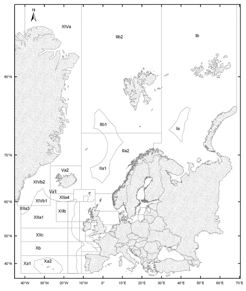
The ICES Statistical Areas delineates the divisions and subdivisions of FAO Major Fishing area 27
-
Limits defining ship classes based on their assigned operating maritime zones. These limits were produced by CEREMA in application of section II.14 of article 1 of decree no. 200945 amended on 30 August 1984. Navigation categories are defined in article 223.2 of the rules appended to the order of 23 November 1987 on shipping safety.
-
<strong>This data is not up to date with the order dated 30 August 2021 amending the order dated 23 November 1987 on ship safety, which now raises the limit for category 4 ships to 5 miles from the nearest coast.</strong> The navigation category allocated to a ship is indicated on its shipping license, together with any applicable restrictions. This limit was produced by Shom in application of section II.14 of article 1 of decree no. 84-810 amended on 30 August 1984. Navigation categories are defined in article 110.10 of the rules appended to the order of 23 November 1987 on shipping safety.
-
Le code officiel géographique rassemble les codes et libellés des communes, des cantons, des arrondissements, des départements, des régions, des collectivités d'outre-mer et des pays et territoires étrangers au 1er janvier de chaque année. Le code contient donc 8 jeux de données: - la liste des communes de la métropole et Dom (toutes les communes ayant existé depuis 1943), - la liste des communes existantes au 1 janvier 2017, - l'historique des communes, - la liste des cantons, - la liste des arrondissements, - la liste des départements, - la liste des régions, - la liste des pays et territoires étrangers. --- Etat de disponibilité de la donnée : - Data.gouv et INSEE : données téléchargeables au format texte et en licence ouverte (si diffusion depuis les 2 sites). Mise à jour annuelle. - PIGMA : "Liste des cantons" (2014) et "Liste des départements" (2014) téléchargeables au format PDF et sous-restriction du droit moral. Aucune fréquence de mise à jour. - Géocatalogue : "Liste des communes existantes au 1 janvier 2017", "Liste des départements" et "Liste des régions" (2016) téléchargeables au format csv ou texte. Aucune fréquence de mise à jour.
-
Geographic information layer including the Transverse limit of the sea - mainland France, French Guiana, Martinique and Guadeloupe. This layer must be considered as an initial version to be validated locally by the competent services. Shom actively seeks out any information which could complete and improve the precision of this layer. The streams and rivers listed correspond to those mentioned in the applicable regulations and/or by a competent Government service. An inventory of existing legal and geographic information was drawn up prior to production in the form of an enquiry targeting services during the second half of 2014. The source legal text and a summary of digital conversion processes is available for each boundary proposed.Updated july 2018
-

The "Sovereignty and jurisdiction maritime spaces of France" product contains the areas of sovereignty and jurisdiction maritime spaces of France all around the world.<br /><br /> It is constituted of 2D areas objects split into four categories :<br /> - the territorial sea (from baselines to a distance of 12 nautical miles or to maritime boundaries with neighbouring countries);<br /> - the contiguous zone (from 12 nautical miles to 24 nautical miles from the baselines or to maritime boundaries with neighbouring countries);<br /> - the exclusive economic zone (EEZ) (from 12 nautical miles to 200 nautical miles from the baselines or to maritime boundaries with neighbouring countries);<br /> - the continental shelf over the 200 nautical miles limit (from 200 nautical miles from the baselines to the limits recommended by the Commission on the Limits of the Continental Shelf (CLCS) or to the maritime boundaries with neighbouring countries).<br /> Internal waters, which constitute a space of sovereignty beyond the baselines, are not included in the "Sovereignty and jurisdiction maritime spaces of France" product.<br /> The "Sovereignty and jurisdiction maritime spaces of France" product may not be considered as an enforceable right. Only the “Maritime limits and boundaries” product, that can be displayed and interrogated on the website data.shom.fr (maritime boundaries category) and also downloaded on the French national portal of maritime limits (https://maritimelimits.gouv.fr), may be considered so.<br /><br /> December 2022 version.
-
Pôles de la CAPB correspondant aux anciens EPCI
-
The product “Maritime limits and boundaries” (French: “Délimitations maritimes”) gathers all the elements used for the definition of the maritime spaces under the French sovereignty or jurisdiction through the world. Those spaces are defined by the Ordonnance n° 2016-1687 of 8 December 2016 relating to maritime spaces under sovereignty or jurisdiction of the French Republic. This ordonnance is the transcription in the French legislation of the United Nations Convention on the Law of the Sea (UNCLOS) which was signed in Montego Bay (Jamaica) on 10 December 1982 end ratified by France on 11 April 1996. These elements of maritime limits and boundaries come from the limits computed by Shom on the basis of International Law, from the international agreements relating to maritime boundary and the technical conventions ratified between France and other States, from the decisions of international juridical bodies, from the recommendations of the Commission of the Limits of the Continental Shelf (UNO) or from unilateral claims from France in the absence of agreement. The elements are divided into seven themes: 1- Straight baselines 2- Outer limits of the territorial sea (12 nautical miles) 3- Outer limits of the contiguous zone (24 nautical miles) 4- Outer limits of the exclusive economic zone (200 nautical miles) 5- Maritime boundaries established by a bilateral agreement or decided by an international juridical body 6- Maritime boundaries unilaterally claimed by France in the absence of agreement 7- Outer limit of the continental shelf beyond 200 nautical miles December 2022 version