 Catalogue PIGMA
CDS-OMP
Type of resources
Available actions
Topics
Keywords
Contact for the resource
Provided by
Formats
Update frequencies
status
-
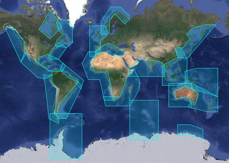
X-TRACK, is a regional altimeter products for coastal applications. It has been developed in order to optimize the completeness and the accuracy of the sea surface height information derived from satellite altimetry in coastal ocean areas. 1hz alongtrack SLA are available in 23 regions for different altimetric missions (Topex, Jason-1&2, Geosat, Ers2, Envisat). SLA is computed on a reference track. X-TRACK SLA files hold alongtrack SLA data together with MSSH, FES2012 tide, Dynamic Atmospheric Corrections and distance to coast parameters. Users can both retrieve filtered and non-filtered data. X-TRACK areas : | short name | long name | |:------------|:---------------------------------| | adelie | Adelie-Mertz | | amazon | Amazon | | asa | Atlantic South America | | chinasea | China Sea | | drake | Drake passage | | eaustralia | East Australia | | gom | Gulf of Mexico - Caribbean Sea | | gulfstream | Gulf Stream | | hudson | Hudson Bay | | humboldt | Humboldt current | | kerguelen | Kerguelen Islands | | labrador | Labrador Sea | | medsea | Mediterranean Sea | | nea | North East Atlantic | | nindian | North Indian Ocean | | norway | Norway | | nwa | North West America | | nwp | North West Pacific | | sea | South and East Africa | | wafrica | West Africa | | waustralia | West Australia | | wla | West Latin America - California | | wtp | West Tropical Pacific |
-
X-TRACK, is a regional altimeter products for coastal applications. It has been developed in order to optimize the completeness and the accuracy of the sea surface height information derived from satellite altimetry in coastal ocean areas. 1hz alongtrack SLA are available in 23 regions for different altimetric missions (Topex, Jason-1&2, Geosat, Ers2, Envisat). SLA is computed on a reference track. X-TRACK SLA files hold alongtrack SLA data together with MSSH, FES2012 tide, Dynamic Atmospheric Corrections and distance to coast parameters. Users can both retrieve filtered and non-filtered data. X-TRACK areas : | short name | long name | | :----------------- | :---------------------------------- | | adelie | Adelie-Mertz | | amazon | Amazon | | asa | Atlantic South America | | chinasea | China Sea | | drake | Drake passage | | eaustralia | East Australia | | gom | Gulf of Mexico - Caribbean Sea | | gulfstream | Gulf Stream | | hudson | Hudson Bay | | humboldt | Humboldt current | | kerguelen | Kerguelen Islands | | labrador | Labrador Sea | | medsea | Mediterranean Sea | | nea | North East Atlantic | | nindian | North Indian Ocean | | norway | Norway | | nwa | North West America | | nwp | North West Pacific | | sea | South and East Africa | | wafrica | West Africa | | waustralia | West Australia | | wla | West Latin America - California | | wtp | West Tropical Pacific |
-
X-TRACK, is a regional altimeter products for coastal applications. It has been developed in order to optimize the completeness and the accuracy of the sea surface height information derived from satellite altimetry in coastal ocean areas. 1hz alongtrack SLA are available in 23 regions for different altimetric missions (Topex, Jason-1&2, Geosat, Ers2, Envisat). SLA is computed on a reference track. X-TRACK SLA files hold alongtrack SLA data together with MSSH, FES2012 tide, Dynamic Atmospheric Corrections and distance to coast parameters. Users can both retrieve filtered and non-filtered data. X-TRACK areas : | short name | long name | |:------------|:---------------------------------| | adelie | Adelie-Mertz | | amazon | Amazon | | asa | Atlantic South America | | chinasea | China Sea | | drake | Drake passage | | eaustralia | East Australia | | gom | Gulf of Mexico - Caribbean Sea | | gulfstream | Gulf Stream | | hudson | Hudson Bay | | humboldt | Humboldt current | | kerguelen | Kerguelen Islands | | labrador | Labrador Sea | | medsea | Mediterranean Sea | | nea | North East Atlantic | | nindian | North Indian Ocean | | norway | Norway | | nwa | North West America | | nwp | North West Pacific | | sea | South and East Africa | | wafrica | West Africa | | waustralia | West Australia | | wla | West Latin America - California | | wtp | West Tropical Pacific |
-
X-TRACK, is a regional altimeter products for coastal applications. Along-track tidal constants (amplitude, phase lags and associated estimation errors for 73 constituents) derived from the X-TRACK T/P and Jason 1&2 is available every 6-7 km along the satellite ground tracks. X-TRACK areas : | short name | long name | |:------------|:---------------------------------| | adelie | Adelie-Mertz | | amazon | Amazon | | asa | Atlantic South America | | chinasea | China Sea | | drake | Drake passage | | eaustralia | East Australia | | gom | Gulf of Mexico - Caribbean Sea | | gulfstream | Gulf Stream | | hudson | Hudson Bay | | humboldt | Humboldt current | | kerguelen | Kerguelen Islands | | labrador | Labrador Sea | | medsea | Mediterranean Sea | | nea | North East Atlantic | | nindian | North Indian Ocean | | norway | Norway | | nwa | North West America | | nwp | North West Pacific | | sea | South and East Africa | | wafrica | West Africa | | waustralia | West Australia | | wla | West Latin America - California | | wtp | West Tropical Pacific |
-
X-TRACK, is a regional altimeter products for coastal applications. Along-track tidal constants (amplitude, phase lags and associated estimation errors for 73 constituents) derived from the X-TRACK T/P and Jason 1&2 is available every 6-7 km along the satellite ground tracks. X-TRACK areas : | short name | long name | |:------------|:---------------------------------| | adelie | Adelie-Mertz | | amazon | Amazon | | asa | Atlantic South America | | chinasea | China Sea | | drake | Drake passage | | eaustralia | East Australia | | gom | Gulf of Mexico - Caribbean Sea | | gulfstream | Gulf Stream | | hudson | Hudson Bay | | humboldt | Humboldt current | | kerguelen | Kerguelen Islands | | labrador | Labrador Sea | | medsea | Mediterranean Sea | | nea | North East Atlantic | | nindian | North Indian Ocean | | norway | Norway | | nwa | North West America | | nwp | North West Pacific | | sea | South and East Africa | | wafrica | West Africa | | waustralia | West Australia | | wla | West Latin America - California | | wtp | West Tropical Pacific |
-
The mean and time-varying position of the main Southern Ocean polar fronts has been calculated from a combination of gridded altimetric sea level anomalies and a new climatology of mean sea level constructed from historical data and ARGO T / S profiles.
-
Ocean tide and loading altimetric corrections computed - with SIROCCO Tools : https://sirocco.obs-mip.fr/other-tools/prepost-processing/comodo-tools - from FES2014 atlases : https://doi.org/10.6096/3001 - for all altimetric missions. Validation available at ftp://ftp.legos.obs-mip.fr/pub/ecola/FES2014/CTOH/2021-02-diff-libfes-tools.pdf
-
Climatology of near-inertial currents. Global climatology of near-inertial current characteristics from satellite-tracked drifters. Data analysed : 8500 near-surface satellite-tracked drifter trajectories with drogues attached at 15 m depth.
-
The SIROCCO ocean circulation climate simulations cover the western Mediterranean Sea ( 33°N - 44.5°N / 1.2°W - 16.3°E ) and the periods from 2000 to 2020, from 2030 to 2049, and form 2080 to 2099. It is based on the BlueLion configuration of the Symphonie hydrodynamic model (Marsaleix et al., 2008, 2019). The horizontal resolution of the model bipolar grid (1230 x 1308) varies from 340 m in the northwestern Mediterranean to 4.5 km in the Ionian Sea. The vertical grid has vanishing quasi-sigma 50 levels. This dataset includes daily files of sea surface height, temperature, salinity and current velocities. This simulations were developed in the framework of the ANR POPNCO and the PPR RIOMAR. The initial and open boundary conditions, the atmospheric forcing and the rivers discharge were provided by the CNRM-RCSM6B, regional climate system model (atmosphere, ocean, land surface hydrology) developed at CNRM (Météo-France) over the Mediterranean CORDEX domain (Med-CORDEX). This coupled simulation is based on the NEMO model at 1/12° for the ocean, the Aladin-Climat model at 12 km for the atmosphere and the ISBA-CTRIP land surface hydrology model.
-
The SIROCCO ocean circulation simulation covers the western Mediterranean Sea ( 33°N - 44.5°N / 1.2°W - 16.3°E ) and the period from 1990 to 2023. It is based on the BlueLion configuration of the Symphonie hydrodynamic model (Marsaleix et al., 2008, 2019). The horizontal resolution of the model bipolar grid (1230 x 1308) varies from 340 m in the northwestern Mediterranean to 4.5 km in the Ionian Sea. The vertical grid has vanishing quasi-sigma 50 levels. This dataset includes daily files of sea surface height, temperature, salinity and current velocities. This simulation was developed in the framework of the PPR RIOMAR. The initial and open boundary conditions, the atmospheric forcing and the rivers discharge (except from the Gulf of Lion) were provided by the CNRM-RCSM6B, regional climate system model (atmosphere, ocean, land surface hydrology) developed at CNRM (Météo-France) over the Mediterranean CORDEX domain (Med-CORDEX). This coupled simulation is based on the NEMO model at 1/12° for the ocean, the Aladin-Climat model at 12 km for the atmosphere and the ISBA-CTRIP land surface hydrology model. The Gulf of Lion rivers were considered using the hydrology database HydroPortail (http ://www.hydro.eaufrance.fr).