 Catalogue PIGMA
/Human Activities/Industrial Fishing
Type of resources
Available actions
Topics
Keywords
Contact for the resource
Provided by
Years
Formats
Representation types
Resolution
-
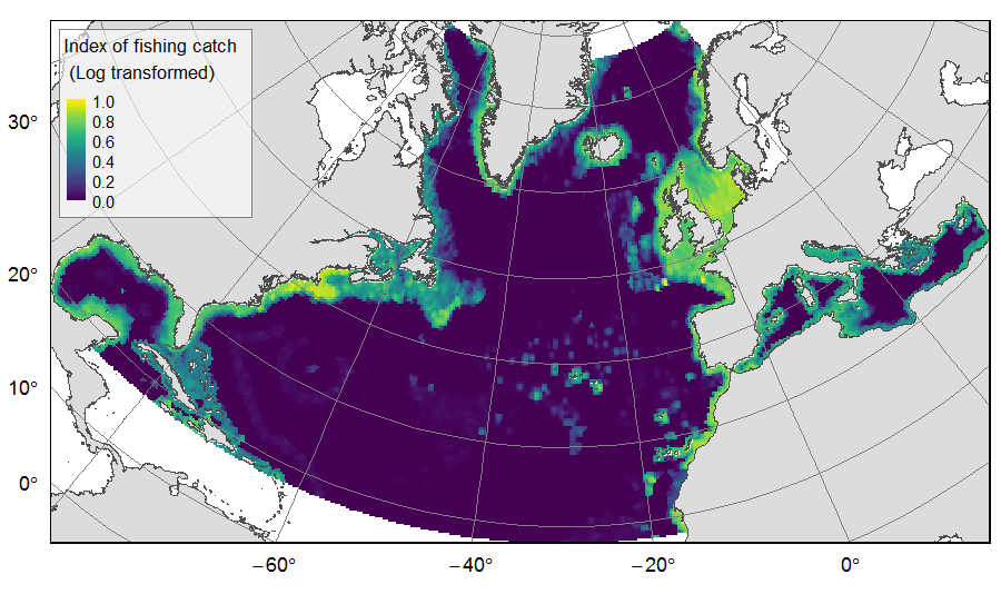
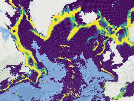
Distribution of catch from deep-sea impacting fishing on the North Atlantic (18°N to 76°N and 36°E to 98°W), for the period 2010-2015. The average of yearly fishing catch for the period 2010-2015 is displayed as an index on the ATLAS grid of 25km * 25km resolution. Source data originated from the Global Fisheries Landings V4.0 database. The dataset was filtered to select only the fishing gears that have an impact on large areas of the seafloor (dredges, bottom trawls, and Danish seines). Within each cell, all remaining catch records were summed to get the total catch rate of the considered year. This dataset was built to feed a basin-wide spatial conservation planning exercise, targeting the deep sea of the North Atlantic. The goal of this approach was to identify conservation priority areas for Vulnerable Marine Ecosystems (VMEs) and deep fish species, based on the distribution of species and habitats, human activities and current spatial management.
-
The GRSF, the Global Record of Stocks and Fisheries, integrates data from three authoritative sources: FIRMS (Fisheries and Resources Monitoring System), RAM (RAM Legacy Stock Assessment Database) and FishSource (Program of the Sustainable Fisheries Partnership). The GRSF content disseminated through this catalogue is distributed to test the logic to generate unique identifiers and review collated stock and fishery data. This beta release can contain errors and we welcome feedback on content and software performance, as well as the overall usability. Beta users are advised to use caution and to not rely in any way on the application and/or trust content and accompanying materials. What is the GRSF? A comprehensive and transparent inventory of stocks and fisheries records across multiple data providers.
-
This dataset was built to feed a basin-wide spatial conservation planning exercise, targeting the deep sea of the North Atlantic, in the framework of the ATLAS H2020 project. This approach aimed to inform Marine Spatial Planning and conservation initiatives for the deep sea of the North Atlantic, by identifying conservation priority areas for the Vulnerable Marine Ecosystems (VMEs) and deep fish species and discussing the efficiency of the current spatial management context relatively to conservation stakes. This publication provides (1) the links to spatial datasets used as an input, (2) the R scripts used to run the final conservation scenarios together with associated table of targets and connectivity matrix, that can be run on the input data, and (3) the outputs of the final scenarios constructed and computed for ATLAS. Produced by IFREMER. This output reflects the authors’ views and the European Union is not responsible for any use that may be made of the information it contains. Please note that you use these data at your own risk. No warranty is expressed or implied and no liability is accepted for any inconveniences or damages that may ensue from their use.
-

This is the FAO Fishery and Aquaculture Reference Data repository: Codes and reference data for fishing gear, species, currencies, commodities, countries and others.
-
Global Fishing Watch is working across the globe to provide governments and authorities with actionable reports and capacity building to help strengthen fisheries monitoring and compliance. Our global team of experts produce analyses to inform monitoring, control and surveillance of fisheries in five key areas: - Illegal, unreported and unregulated fishing - Transshipment - Port controls - Marine protected areas - Operation support Collaboration and information sharing are integral to achieving well-managed fisheries. By working with stakeholders and making analyses available to national, regional and intergovernmental partners, Global Fishing Watch is enabling fisheries agencies to make more informed and cost-efficient decisions. Topics: - Commercial fishing, Global Fishing Watch is harnessing innovative technology to turn transparent data into actionable information and drive tangible change in the way that fisheries are governed. - Transshipment, Through publicly sharing map visualisations and creating data and analysis tools, we seek to inform management and policy efforts and provide a more complete picture of transshipment at sea. - Marine protected areas, Global Fishing Watch is harnessing the data and technology revolution to support the effective design, management and monitoring of marine protected areas.