 Catalogue PIGMA
CSV
Type of resources
Available actions
Topics
Keywords
Contact for the resource
Provided by
Years
Formats
Representation types
Update frequencies
status
Scale
Resolution
-
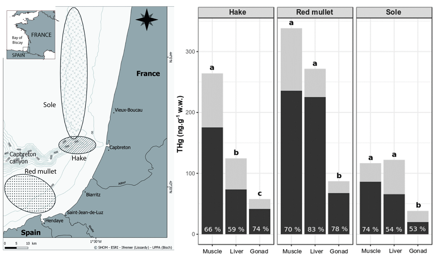
This dataset gather isotopic ratios (carbon and nitrogen) and concentrations of mercury species (methyl and inorganic mercury) measured in several tissues (muscle, liver and gonad) for three commonly consumed fish species from the south Bay of Biscay (France) in 2017 and 2018.
-

-
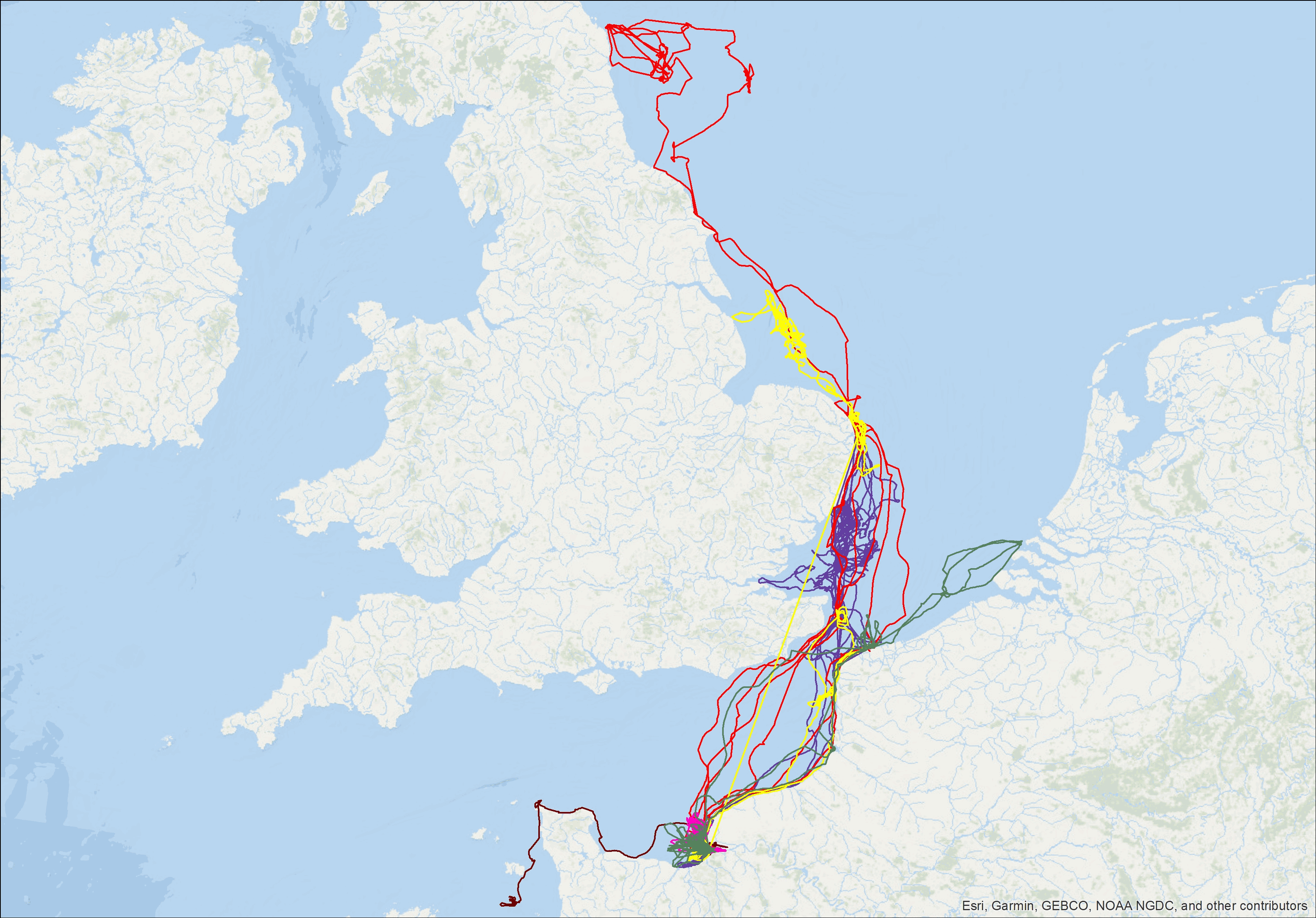
Tracking data of 7 grey seals were obtained from the deployment of Fastloc GPS/GSM tags developed by the Sea Mammal Research Unit (UK). Full tag description is available at: http://www.smru.st-andrews.ac.uk/Instrumentation/GPSPhoneTag/. The tags include a wet-dry sensor from which haulout events are recorded, a pressure sensor providing detailed dive data, as well as a Fastloc GPS recording irregular locations when the seal is not underwater. Data is stored onboard and transmitted via the GSM network when the seal is in the reception range. The data provided here are the individual GPS locations of the seals fitted with these tags for an average duration of 135 days.
-

Opportunistic macroalgae blooms (green tides) data are collected during monitoring surveys on the English Channel / Bay of Biscay French coasts since 2008 (Quadrige program code : BLOOMS). Protocols are implemented in the European Water Framework Directive.
-
Aires géographiques des appellations d'origine contrôlées (AOC)/protégées (AOP). Le fichier liste pour chaque commune, identifiée par son département, son nom et son code INSEE, les aires géographiques des appellations AOC/AOP qui se situent sur la commune
-
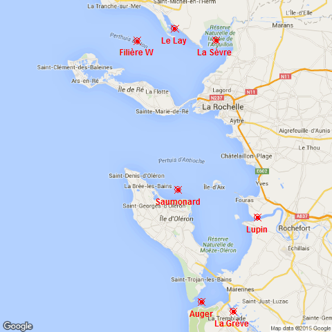
The SAPERCHAIS program (Suivi des Apports marins et terrigènes dans la mer des PERtuis CHarentAIS) was developed to monitor environmental fluctuations in the Pertuis Charentais Sea by an hydrological watchfulness. Seven stations, representatives of terrigenous or marine inputs, have been followed from 2011 to 2014. From north to south, the main four rivers of the Pertuis, Le Lay, La Sèvre, Charente and Seudre, and the three maritime inputs of each strait, Breton, Antioche and Maumusson. At each station, temperature and salinity were recorded in situ, just below the surface, with a high frequency resolution (10 minutes) . This work was supported by grants from Région Poitou-Charentes and European Regional Development Fund to the Ifremer "Developpement Durable de la Pêche et de la Conchyliculture" project.
-
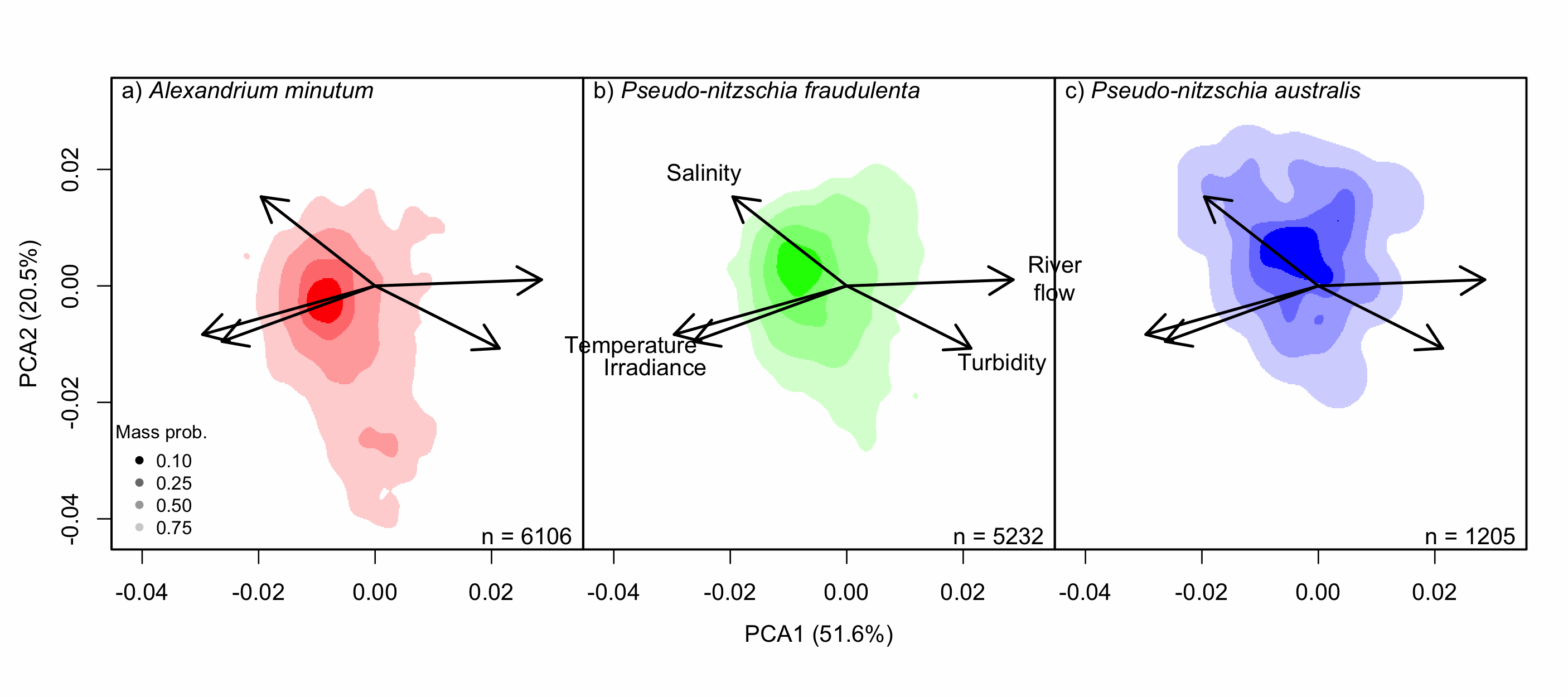
Understanding the spatial and temporal preferences of toxic phytoplankton species is of paramount importance in managing and predicting harmful events in aquatic ecosystems. In this study we address the realised niche of the species Alexandrium minutum, Pseudo-nitzschia fraudulenta and P. australis. We used them to highlight distribution patterns at different scales and determine possible drivers. To achieve this, we have developed original procedures coupling niche theory and habitat suitability modelling using abundance data in four consecutive steps: 1) Estimate the realised niche applying kernel functions. 2) Assess differences between the species’ niche as a whole and at the local level. 3) Develop habitat and temporal suitability models using niche overlap procedures. 4) Explore species temporal and spatial distributions to highlight possible drivers. Data used are species abundance and environmental variables collected over 27 years (1988-2014) and include 139 coastal water sampling sites along the French Atlantic coast. Results show that A. minutum and P. australis niches are very different, although both species have preference for warmer months. They both respond to decadal summer NAO but in the opposite way. P. fraudulenta realised niche lies in between the two other species niches. It also prefers warmer months but does not respond to decadal summer NAO. The Brittany peninsula is now classified as an area of prevalence for the three species. The methodology used here will allow to anticipate species distribution in the event of future environmental challenges resulting from climate change scenarios.
-
There are at least a dozen small hyper-turbid estuaries facing the Bay of Biscay, geographically situated between the two major estuaries of the Gironde and the Loire. MAGEST and SYVEL high-frequency multi-site monitoring revealed that the Loire, and to a lesser extent the Gironde, are subject to summer hypoxia. These observations raised the question of the potential occurrence of hypoxia in the small estuaries in between, motivating an investigation of dissolved oxygen in one of them, the Charente estuary. Oxygen and salinity sensors were placed at L'Houmée (2019), Tonnay-Charente (2018; 2019), Rochefort (2020; 2021; 2022), Martrou (2020) during summer, the most critical period for dissolved oxygen; a multiparameter probe was placed at Tonnay-Charente from April to November 2020. Longitudinal investigations along the estuary axis were also carried out during the summers of 2018 and 2019. All the measurements were acquired at 0.5 ± 0.2 meters below the surface. The dataset enabled us to identify the occurrence of summer hypoxia and an oxygen depletion zone in the Charente estuary. These results resulted in the implementation of high-frequency monitoring at Tonnay-Charente, operational since November 2020.
-

The Commission for the Conservation Southern Bluefin Tuna collects a variety of data types from its Members and Cooperating Non-Members, including total catch, catch and effort data, and catch at size data. Catch, size and trade information is also collected through the Commission's Catch Documentation Scheme, Japanese import statistics, and other monitoring programs. Annual catches provided on this page are reported on a calendar year basis. CCSBT Members use quota years (not calendar years) for managing catching limits, but quota years differ between Members, so calendar years are used to provide catches on a common timescale. Relevant subsets and summaries of these data are provided below. All figures are subject to change as improved data or estimates become available. In particular, reviews of SBT data in 2006 indicated that southern bluefin tuna catches may have been substantially under-reported over the previous 10-20 years and the data presented here do not include estimates for this unreported catch. Also, data for the last reported year of catch (2020) are preliminary and are subject to revision. Any latitudes and longitudes presented in these summaries represent the north western corner of the relevant grid, which is a 5*5 grid unless otherwise specified. Other information on Members and Cooperating Non-Members fishing activities appears in the reports of the Extended Scientific Committee, Compliance Committee and Extended Commission.
-
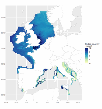
The ICES Working Group on Fisheries Benthic Impact and Trade-offs (WGFBIT) has developed an assessment framework based on the life history trait longevity, to evaluate the benthic impact of fisheries at the regional scale. In order to apply this framework to the Mediterranean sea, several Mediterranean longevity databases were merged together with existing North-East Atlantic ones to develop a common database. Longevity was fuzzy coded into four longevity classes: <1, 1-3, 3-10 and >10 years. Both benthic mega and macrofauna organisms are included in this dataset. Further details about both the purpose and the methodology may be found in ICES (2022) and Cuyvers et al. (2023). The result of the final dataset merging is one dataset containing the fuzzy coded average longevity (and standard deviation) for 2264 taxa and for each, the number of databases used.