 Catalogue PIGMA
/La Rochelle/LAR02
Type of resources
Available actions
Topics
Keywords
Contact for the resource
Provided by
Years
Formats
Representation types
Update frequencies
status
Scale
Resolution
-
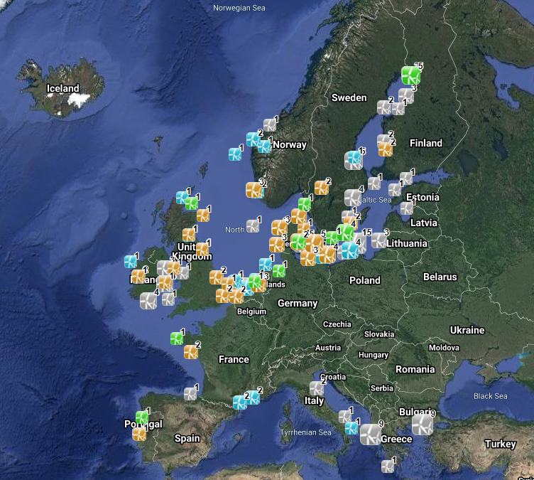
The database on offshore wind farms in the EU was created in 2014 by CETMAR for the European Marine Observation and Data Network (EMODnet). It is the result of the aggregation and harmonization of datasets provided by several sources. It is updated every year and is available for viewing and download on EMODnet Human Activities web portal (www.emodnet-humanactivities.eu). The database contains points and/or (where available) polygons representing offshore wind farms in the following countries: Belgium, Denmark, Estonia, Finland, France, Germany, Greece, Ireland, Italy, Latvia, Lithuania, Netherlands, Norway, Poland, Portugal, Spain, Sweden and United Kingdom. Each point has the following attributes (where available): Name, Nº of turbines, Status (Approved, Planned, Dismantled, Construction, Production, Test site), Country, Year, Power (MW), Distance to coast (metres) and Area (square kilometres). The distance to coast (EEA coastline shapefile) has been calculated using the UTM WGS84 Zone projected coordinate system where data fall in.
-
The GEBCO_2020 Grid was released in May 2020 and is the second global bathymetric product released by the General Bathymetric Chart of the Oceans (GEBCO) and has been developed through the Nippon Foundation-GEBCO Seabed 2030 Project. The GEBCO_2020 Grid provides global coverage of elevation data in meters on a 15 arc-second grid of 43200 rows x 86400 columns, giving 3,732,480,000 data points. Grid Development The GEBCO_2020 Grid is a continuous, global terrain model for ocean and land with a spatial resolution of 15 arc seconds. The grid uses as a ‘base’ Version 2 of the SRTM15+ data set (Tozer et al, 2019). This data set is a fusion of land topography with measured and estimated seafloor topography. It is augmented with the gridded bathymetric data sets developed by the four Seabed 2030 Regional Centers. The Regional Centers have compiled gridded bathymetric data sets, largely based on multibeam data, for their areas of responsibility. These regional grids were then provided to the Global Center. For areas outside of the polar regions (primarily south of 60°N and north of 50°S), these data sets are in the form of 'sparse grids', i.e. only grid cells that contain data were populated. For the polar regions, complete grids were provided due to the complexities of incorporating data held in polar coordinates. The compilation of the GEBCO_2020 Grid from these regional data grids was carried out at the Global Center, with the aim of producing a seamless global terrain model. In contrast to the development of the previous GEBCO grid, GEBCO_2019, the data sets provided as sparse grids by the Regional Centers were included on to the base grid without any blending, i.e. grid cells in the base grid were replaced with data from the sparse grids. This was with aim of avoiding creating edge effects, 'ridges and ripples', at the boundaries between the sparse grids and base grid during the blending process used previously. In addition, this allows a clear identification of the data source within the grid, with no cells being 'blended' values. Routines from Generic Mapping Tools (GMT) system were used to do the merging of the data sets. For the polar data sets, and the adjoining North Sea area, supplied in the form of complete grids these data sets were included using feather blending techniques from GlobalMapper software version 11.0, made available by Blue Marble Geographic. The GEBCO_2020 Grid includes data sets from a number of international and national data repositories and regional mapping initiatives. For information on the data sets included in the GEBCO_2020 Grid, please see the list of contributions included in this release of the grid (https://www.gebco.net/data_and_products/gridded_bathymetry_data/gebco_2020/#compilations).
-
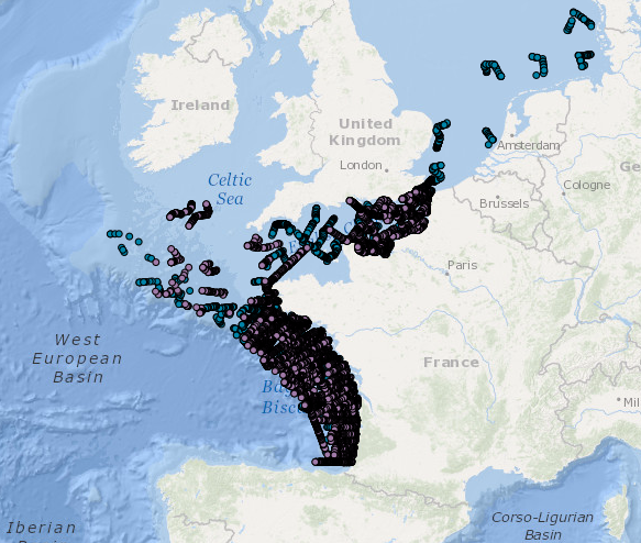
Données d’occurrence des observations de mammifères marins, oiseaux et autre mégafaune marine collectées par le dispositif Megascope sur les campagnes halieutiques et océanographiques (date, position, espèce). jour: jour de l'observation mois: mois de l'observation an: année de l'observation Latitude: y en degrés décimaux Longitude : x en degrés décimaux nom_latin: nom latin de l'espèce identifiée selon taxref cd_ref: code de l'espèce selon taxref v8.0 Survey: nom de la campagne identiteObservateur: nom de l'observateur ayant réalisé l'observation organismeObservateur: nom de l'organisme ayant réalisé l'observation organismeGestionnaireDonnees: nom de l'organisme assurant la gestion de la base de données
-
COAST-HF est un Service National d'Observation qui vise à fédérer et cordonner à l'échelle du littoral français un ensemble de plateformes fixes instrumentées de mesures in situ hautes fréquences pour des paramètres clés des eaux côtières. Ce réseau s'inscrit dans l'Infrastructure de Recherche ILICO. Il est constitué de 14 bouées ancrées instrumentées et autonomes permettant la mesure en continu de paramètres physiques et bio-géochimiques.
-
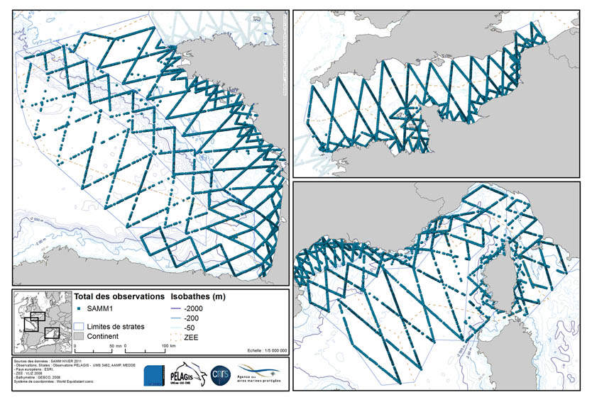
La donnée associée met en évidence les observations réalisées lors de la campagne d'acquisition de données d'Observation sur plateforme aérienne SAMM1 (Suivi aérien de la Mégafaune Marine) réalisée par l'Observatoire PELAGIS.
-
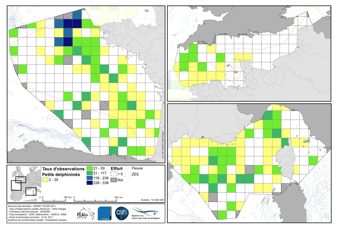
Taux de rencontre en nombre d’observation pour 1000 km d’effort dans chaque maille de 40 km de la ZEE française métropolitaine en hiver 2011/2012 et été 2012. Description de la table attributaire : survey : campagne type : type d'observation maille : taillle de la maille en kilomètre _no_maille : numéro de la maille Les champs suivant correspondent au calcul de taux de rencontre du nombre d'observation pour 1000km d'effort pour chaque espèce ou groupe d'espèce : - [marsouin] Marsouin commun - [grdDauph] Grand dauphin - [lagenor] Lagénorhynque à bec blanc - [pttDelph] : dauphin commun + dauphin bleu et blanc - [globiceph] : Globicephale noir + dauphin de Risso - [cakobab] : cachalot macrocéphale + kogias + baleines à bec - [balenopt] : rorqual commun + petit rorqual + baleine bleue - [phoque] Phoques (gris + veau-marin)