 Catalogue PIGMA
50000
Type of resources
Available actions
Topics
Keywords
Contact for the resource
Provided by
Years
Formats
Representation types
Update frequencies
status
Scale
Resolution
-
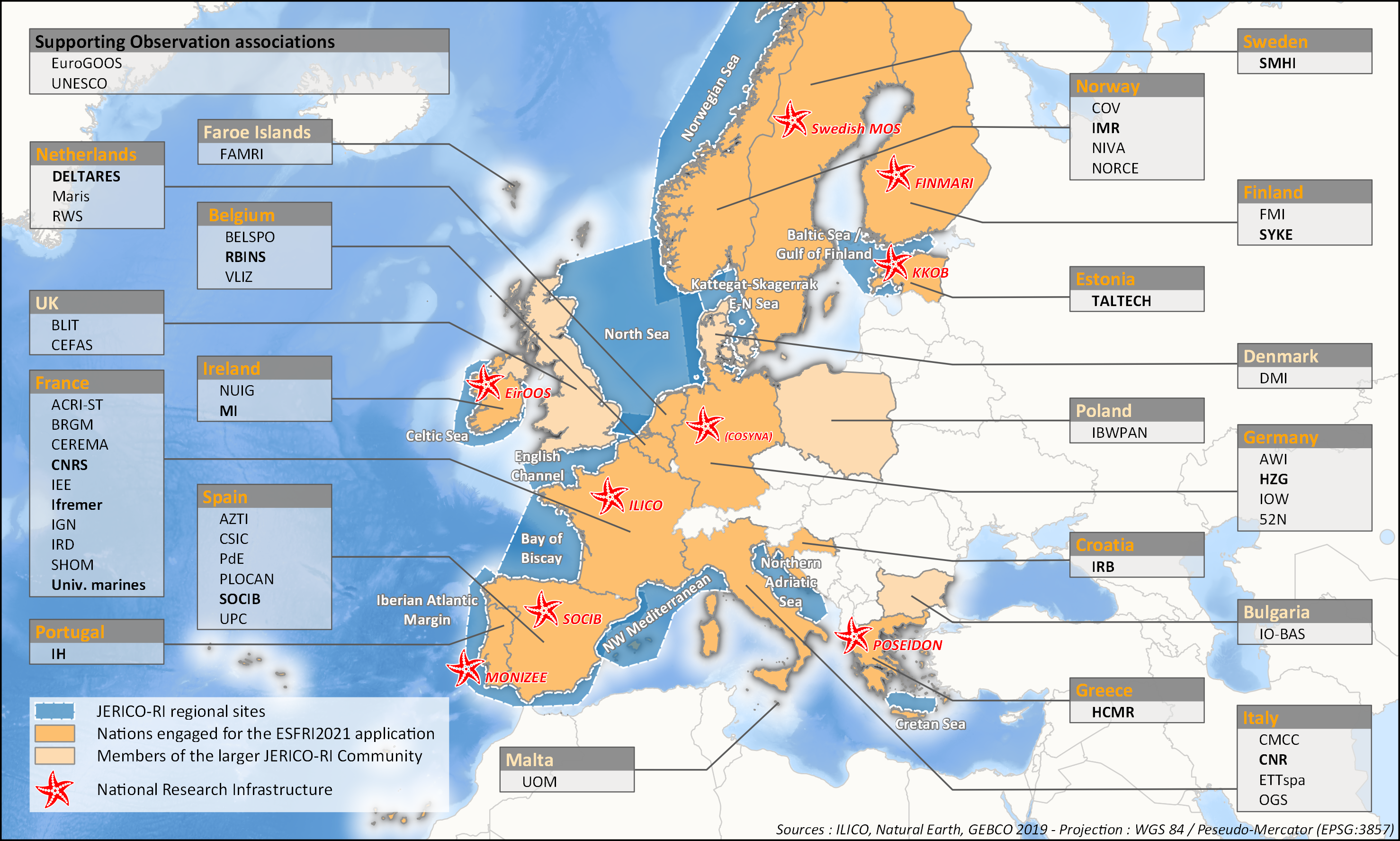
aThis survey action has been undertaken as part of WP6 of the H2020 JERICO-S3 project. Its integration in Sextant is the first step towards a comprehensive and extensive data catalog for the JERICO Research Infrastructure. JERICO-S3, Description of Work - WP6 : Data Management Task 6.2: Data management for coastal platforms (M1-48) (Lead: HCMR) Subtask 6.2.1: Identify and update the overview of JERICO-RI involved platforms and data (SMHI, MARIS, IFREMER) (M1-48) The JERICO dataset catalogue has proven a useful tool for creating an overview of platforms and data relevant for the project this and will be updated. Input from other WP’s will be used to identify the actual JERICO platforms, including the PSS, TNA platforms, and IRS. Partners will collect and describe coastal platforms in the dataset catalogue (technically run in WP7) including pointers to data, which variables (related to EOV’s) published as D6.2. Subtask 6.2.2: Best practice capturing for “mature” platforms with physical and BGC parameters (HCMR, SMHI, CNR, ETT, SOCIB, HZG, RWS) (M6-42). For the following platform types there will be activities supporting data management as defined under T6.4 in close relation to the Virtual Research Environment in WP7: HF radars (CNR), Gliders (SOCIB, ETT), FerryBox (HZG) The work for each platform type will follow basically the same approach and will cooperate with WP4 (PSS) and WP3 (IRS). The experts will identify the existing standards, and possible data management best practices (D6.3). At the end of the project an evaluation will be done of the level of Best Practice adoption at the IRSs and PSSs in the project, as well as the use of the VRE by the partners engaged in WP3 and WP4 (D6.10). This will be done in cooperation with WP3 and WP4, and is an important condition for data to be accessible for use in the Virtual Environment in T7.4.
-
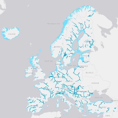
EU-Hydro is a dataset for all EEA38 countries and the United Kingdom providing photo-interpreted river network, consistent of surface interpretation of water bodies (lakes and wide rivers), and a drainage model (also called Drainage Network), derived from EU-DEM, with catchments and drainage lines and nodes. The EU-Hydro dataset is distributed in separate files (river network and drainage network) for each of the 35 major basins of the EEA38 + UK area, in GDB and GPKG formats. The production of EU-Hydro and the derived layers was coordinated by the European Environment Agency in the frame of the EU Copernicus programme.
-
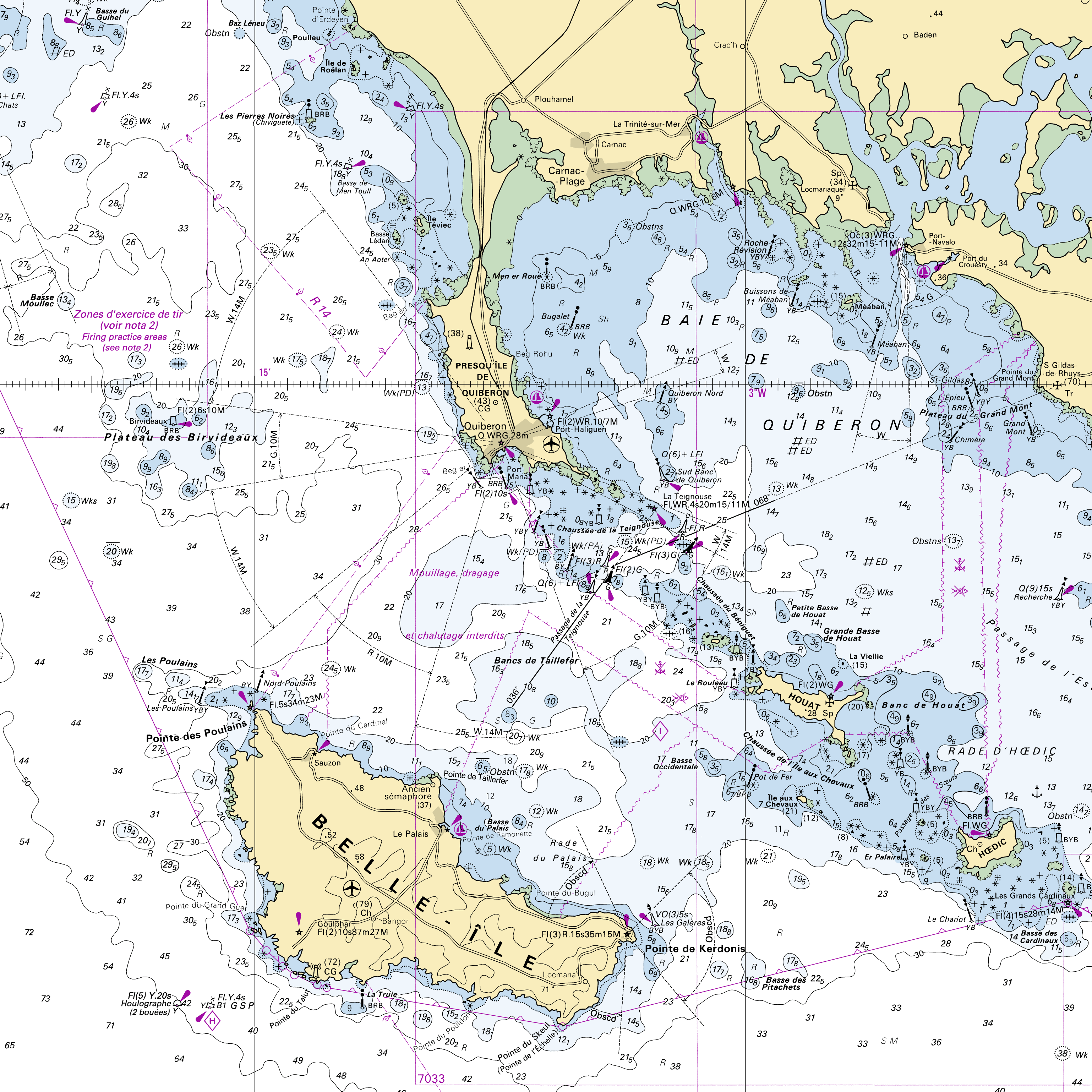
RasterMarine is a series of digital images taken from nautical charts, with no additions, legends or georeferencing information. The RasterMarine range is available at six sets of scales: - RasterMarine10 1:10,000 - RasterMarine25 1:25,000 - RasterMarine50 1:50,000 - RasterMarine100 1:100,000 - RasterMarine350 1:350,000 - RasterMarine1M 1:1,000,000. Unless exceptional circumstances apply, the RasterMarine range is updated on a weekly basis and the modified grid squares are re-published, replacing the previous versions. All corrections, publications, editions and suppressions with an effect on the reference nautical charts are taken into consideration. <br /> 09/07/2026 version <br />
-
-
Évolution de l'urbanisation ( DÉFINITION )au Nord du PNR des Landes de Gascogne entre 2009 et 2014. Analyse de l'urbanisation en fonction des routes primaires et secondaires. Zone d'étude : Le Barp, Mios et Marcheprime. Jeu de données : - "Bâti indifférencié" et "bâti industriel": BD Topo 2009 et BD Topo 2014 - "Routes primaires" et "Routes secondaires" : BD Topo 2009 - Limites des communes : GEOFLA
-
Conversion into the EMODnet format of the published grid for the Capbreton Canyon in 2007: http://dx.doi.org/10.12770/72e2f750-c255-11df-a9b6-005056987263
-
The product "Sea bed sediment 1:50 000" contains 2D surface objects geo-referenced digital data describing the nature of the geological seabed (nature of the sediment, including rock type seabed).
-

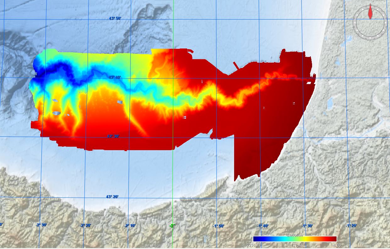
Carte de la géomorphologie du canyon de Capbreton, publiée en 2007 sur la carte morpho-bathymétrique du canyon de Capbreton au 1/50 000. Les objets géographiques sont rassemblés dans quatre fichiers de formes : la physiographie générale de la zone, le thalweg, le lit majeur et les flancs du canyon et les éléments morphologiques. Référence bibliographique : Bourillet Jean-Francois, Augris Claude, Cirac Pierre, Maze Jean-Pierre, Normand Alain, Loubrieu Benoit, Crusson Alban, Gaudin Mathieu, Poirier Dominique, Satra le Bris Catherine, Simplet Laure, Université Bordeaux 1 - Sciences Technologies (2007). Le canyon de Capbreton - Carte morpho-bathymétrique - Échelle 1/50 000. Ifremer. https://doi.org/10.13155/40280 Campagnes à l'origine de cette carte : - LERICOLAIS Gilles, AUGRIS Claude (1994) PLABAS 94/1 cruise, RV Thalia, https://doi.org/10.17600/94070170 - CIRAC Pierre (1998) ITSAS cruise, RV Le Suroît, https://doi.org/10.17600/98020070 - CIRAC Pierre (2001) ITSAS V cruise, RV Thalia, https://doi.org/10.17600/1070060 - AUGRIS Claude (1993) PLABAS cruise, RV Thalia, https://doi.org/10.17600/93000660 - CIRAC Pierre (2001) ITSAS II cruise, RV Le Suroît, https://doi.org/10.17600/1020050 - AUGRIS Claude (1994) PLABAS 94/2 cruise, RV Thalia, https://doi.org/10.17600/94070180 - CIRAC Pierre (2002) ITSAS VI cruise, RV Thalia, https://doi.org/10.17600/2070100
-
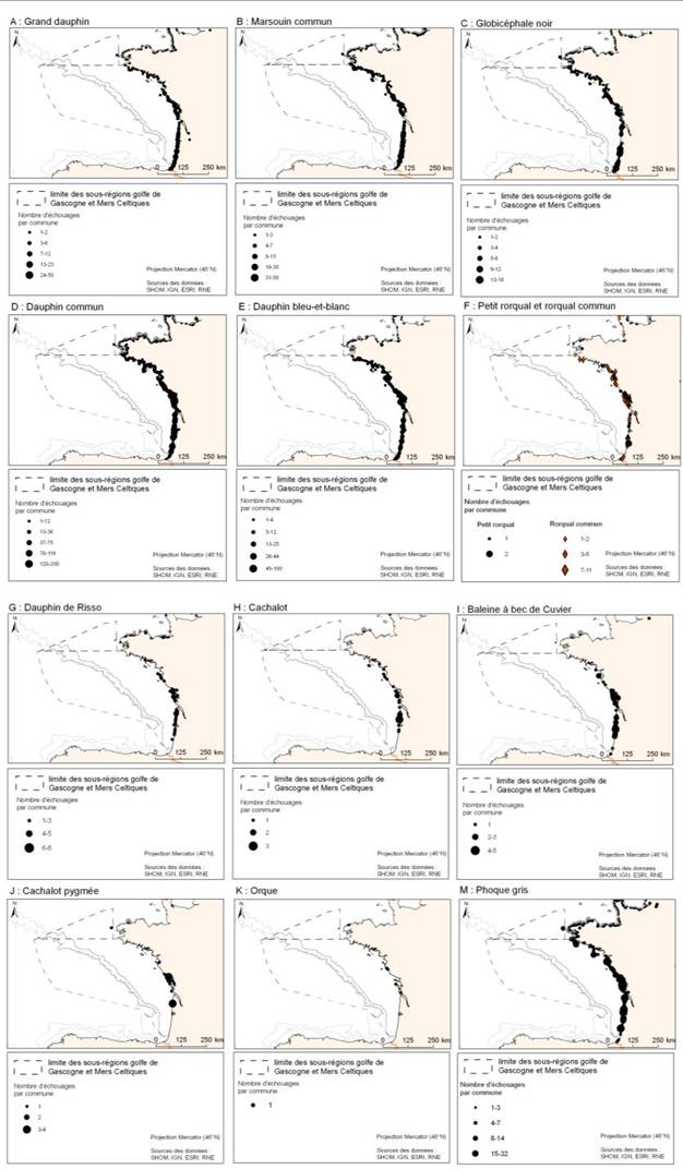
La donnée associée met en évidence les observations d'échouages de mammifères marins réalisées entre 1969 et 2009. Les espèces concernées sont : le grand dauphin, le marsouin commun, le globicéphale noir, le dauphin commun, le dauphin bleu-et-blanc, le petit rorqual, le rorqual commun, le dauphin de Risso, le cachalot, la baleine à bec de Cuvier, le cachalot pygmée, l’orque, le phoque gris et le phoque veau-marin.
-

Répertoire des maternelles sur le Pays du Grand Bergeracois. Cette donnée comprend notamment les adresses, les coordonnées gps, les horaires du service en question.