 Catalogue PIGMA
Current
Type of resources
Available actions
Topics
Keywords
Contact for the resource
Provided by
Years
Formats
Update frequencies
-
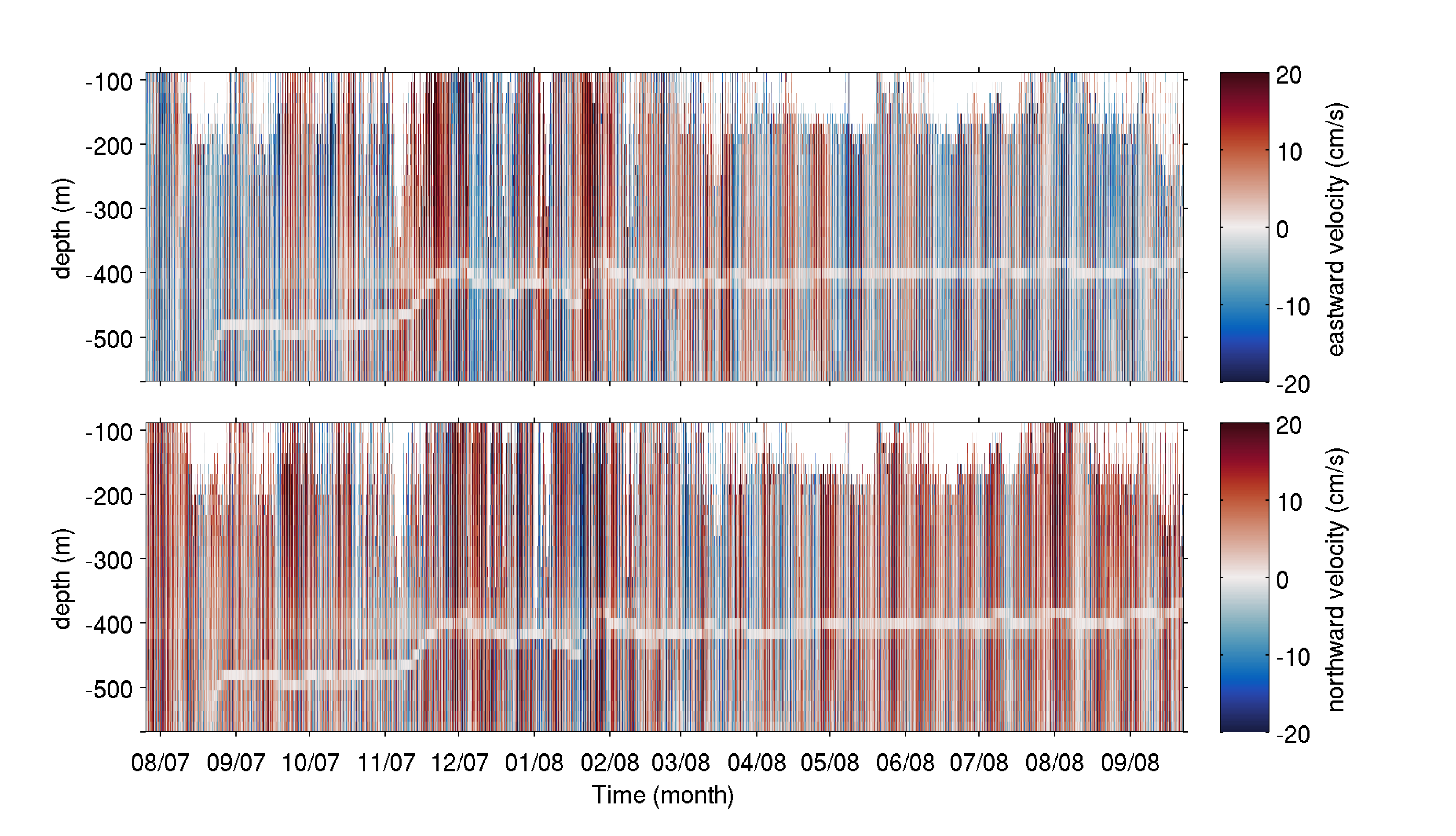
The mooring was deployed on 25 July 2007 from the R/V Haakon Mosby at 80.601°N, 7.119°E (depth of 745 m) in the Yermak Pass over the Yermak Plateau north of Svalbard. It comprised an upward-looking RDI 75kHz Long Ranger Acoustic Doppler Current Profiler (ADCP) at 585 m with 16 m vertical resolution and a 1hour sampling time, and an ocean profiler on a taut cable between 130 and 530 m. The mooring was recovered on 23 September 2008 by the K/V Svalbard. The dataset is composed of the raw data from the ADCP, after declination correction. A white shaded zone is visible in the data between 380 and 500 m depth throughout the time series. It corresponds to the reflection of the acoustic bins on the profiler stuck on the cable.
-
Arc-en-Sub: Seafloor current meter records at Rainbow Massif (AES_C01, AES_C02A, AES_C02B), May 2022
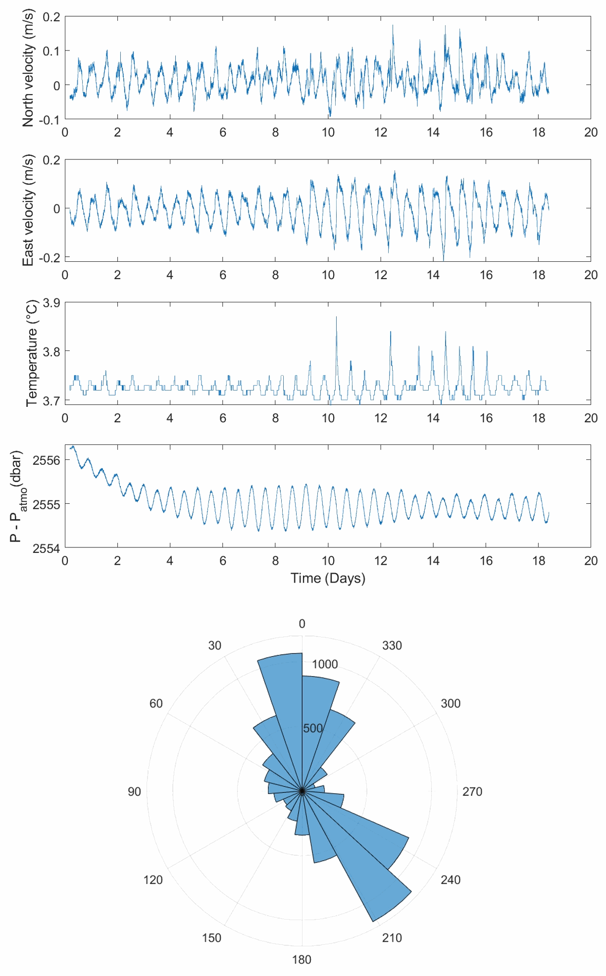
Current meter Nortek Aquadopp data. Data for 2 current meter deployments of NORTEK Aquadopp instruments at the Rainbow Massif. Instruments where kindly provided by the Parc National d'Instrumentation Océanographique de l'INSU. Data is provided in 2 sets of files, corresponding to deployments AES_C01 and AES_C02. The instruments where installed in a broadband OBS (BBOBS) from the INSU OBS National Park. Deployment AES_C02 includes two lowerings (see information below, indicated as deployments AES_C02A and AES_C02B). AES_C01 with current meter serial number : A6L6094 (head) AQD11097 (Hardware), deployed on BB03 with deployment AES_B01_BB3. Bottom position: 36.23544°N, 33.91036°W, 2505 m waterdepth. AES_C02_A with current meter serial number : A6L6127 (head) AQD11247 (Hardware), deployed on BB02, deployment AES_B03_BB02. Bottom position: 36.22233°N, 33.87996°W, 1950m waterdepth. AES_C02_B with current meter serial number : A6L6127 (head) AQD11247 (Hardware), deployed on BB02, deployment AES_B06_BB02. Bottom position: 36.2020833°N, 33.8118833°W, 2557m waterdepth. Data are provided in two zipped files that include: AESC0101.aqd: Aquadopp binary file AESC0101.dat: Ascii table of data - full record AESC0101.dia: Aescii data file - partial record AESC0101.hdr: Instrument parameter information and description of columns in AESC0101.dat AESC0101.mat: Matlab file corresponding to AESC0101.dat AESC0101.ssl: Log of instrument (error and info messages) In addition to several instrument logs: AESC01_start.log AES_C01_deploy.dep AESC01_start.dep The ascii file contains 27 columns as follows: 1 Month (1-12) 2 Day (1-31) 3 Year 4 Hour (0-23) 5 Minute (0-59) 6 Second (0-59) 7 Error code 8 Status code 9 Velocity (Beam1|X|East) (m/s) 10 Velocity (Beam2|Y|North) (m/s) 11 Velocity (Beam3|Z|Up) (m/s) 12 Amplitude (Beam1) (counts) 13 Amplitude (Beam2) (counts) 14 Amplitude (Beam3) (counts) 15 Battery voltage (V) 16 Soundspeed (m/s) 17 Soundspeed used (m/s) 18 Heading (degrees) 19 Pitch (degrees) 20 Roll (degrees) 21 Pressure (dbar) 22 Pressure (m) 23 Temperature (degrees C) 24 Analog input 1 25 Analog input 2 26 Speed (m/s) 27 Direction (degrees)
-
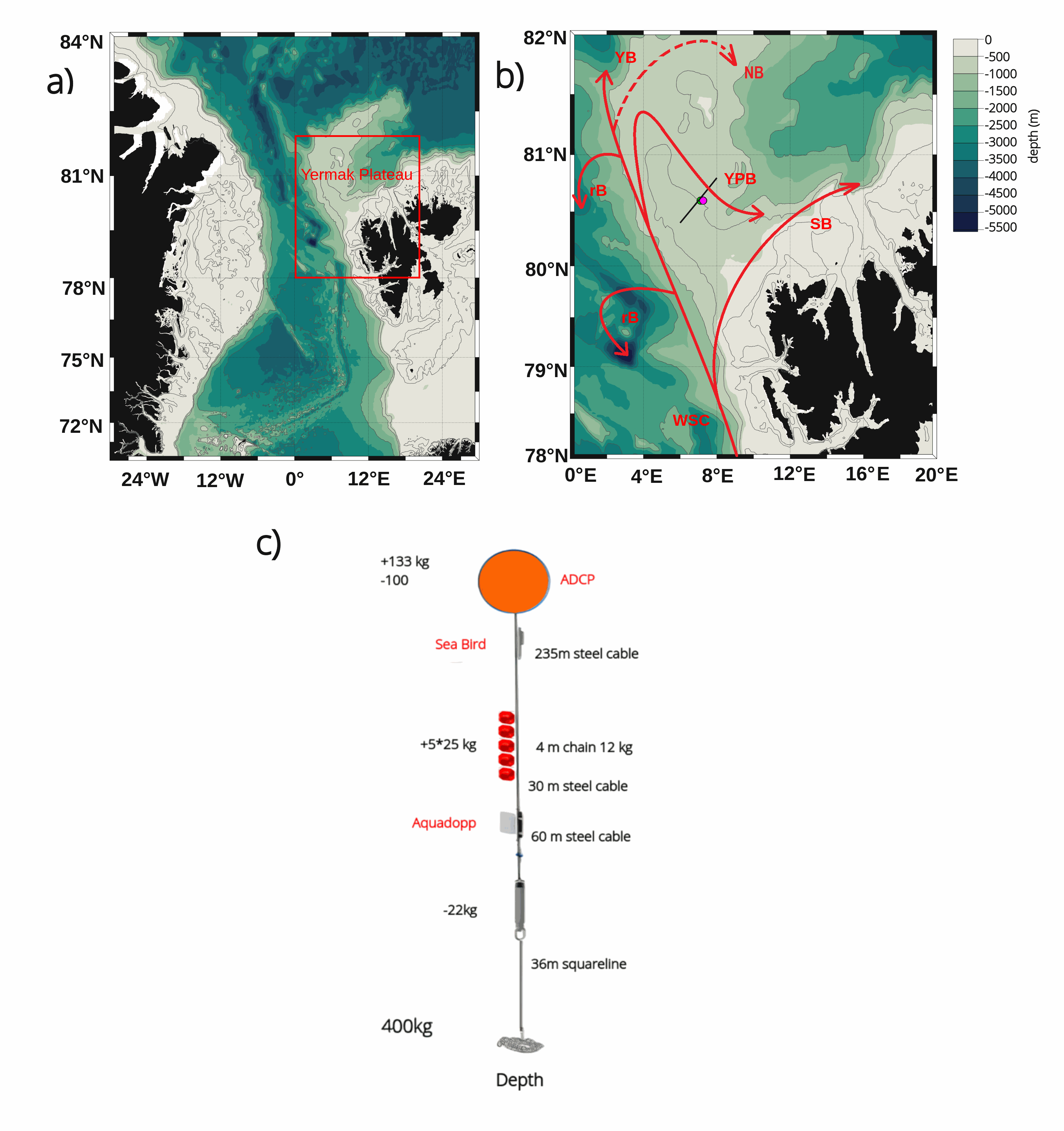
The mooring was deployed on 15 September 2017 from Norwegian Research Vessel Lance at 80.6°N and 7.26°E (depth of 730 m) in the Yermak Pass over the Yermak Plateau north of Svalbard. It comprised 3 instruments: an upward-looking RDI 75kHz, a Long Ranger Acoustic Doppler Current Profiler (ADCP) at 340 m with 16 m vertical resolution (25 bins of 16 m each) and a 2-hour sampling time; a Seabird SBE37 measuring temperature, salinity and pressure at 348 m with 10-minute sampling time; and an Aquadopp current meter at 645 m with a 2-hour sampling time. The mooring was retrieved on the 19 July 2020 by Norwegian Icebreaker K.V. Svalbard. The present dataset features: (i) the ADCP 50-hour smoothed daily velocities, conservative temperature and pressure time series interpolated every 10 meters within the 20-330m layer, (ii) the Aquadopp 50-hour smoothed daily velocities and pressure time series at 645 m; and (iii) the SBE37 50-hour smoothed daily conservative temperature, absolute salinity and pressure time series at 348 m.
-
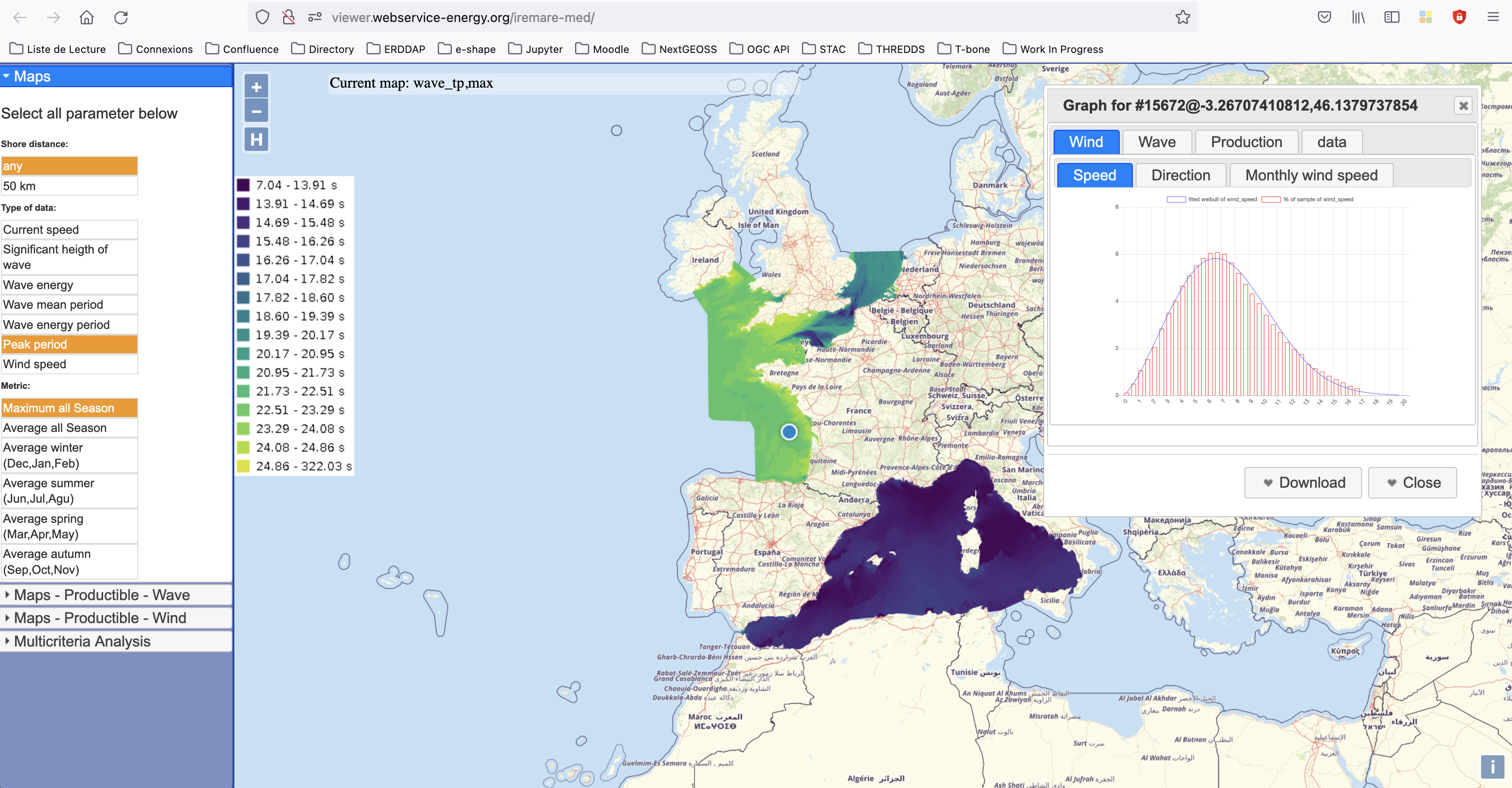
IREMARE (Marine Renewable Energie Resource Information) is a project funded by ADEME (Agency for the Environment and Energy Control, French Public Institution), convention n°1505C0027. It is dedicated to the production and dissemination of high level information about Marine Renewable Energy (MRE) resource. The information produced during IREMARE project covers the western coast of France (Atlantic, English Channel and North Sea) and can be used for national down to local scale studies. IREMARE-MED (Informations sur la Ressource pour les Energies MArines REnouvelables en MEDiterranée/Marine Renewable Energie Resource Information in the Mediterranean) is a project funded by ADEME (Agence de l'Environnement et de la Maitrise de l'Energie/Agency for the Environment and Energy Control, French Public Institution), convention n°1705C0016. It is dedicated to the production and dissemination of high level information about Marine Renewable Energy (MRE) resource. The data comes from the HOMERE database (Boudiere et al. 2013) for the zone Atlantic, Channel and North Sea and from the ANEMOC-2 dataset (Tiberi-Wadier et al. 2016) for the Mediterranean Sea.