 Catalogue PIGMA
10 m
Type of resources
Available actions
Topics
Keywords
Contact for the resource
Provided by
Years
Formats
Representation types
Update frequencies
status
Scale
Resolution
-
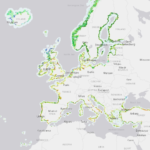
The Coastal Zones (CZ) LC/LU product for 2012 is providing a detailed Land Cover / Land Use (LC/ LU) dataset for areas along the coastline of the EEA38 countries and the United Kingdom, with reference year 2012 for the classification. This product monitors landscape dynamics in European coastal territory to an inland depth of 10 km with a total area of approximately 730,000 km², with all the relevant areas (estuaries, coastal lowlands, nature reserves). The production of the coastal zone layers was coordinated by the European Environment Agency (EEA) in the frame of the EU Copernicus programme, as part of the Copernicus Land Monitoring Service (CLMS) Local Component. The Coastal Zones product covers a buffer zone of coastline derived from EU-Hydro v1.1. Land Cover/Land Use (LC/LU) layer is extracted from Very High Resolution (VHR) satellite data and other available data. The class definitions follow the pre-defined nomenclature on the basis of Mapping and Assessment of Ecosystems and their Services (MAES) typology of ecosystems (Level 1 to Level 4) and CORINE Land Cover adapted to the specific characteristics of coastal zones. The classification provides 71 distinct thematic classes with a Minimum Mapping Unit (MMU) of 0.5 ha and a Minimum Mapping Width (MMW) of 10 m. The product is available for the 2012 and 2018 reference year including change mapping. This CZ dataset is distributed in vector format, in a single OGC GeoPackage SQLite file covering the area of interest.
-

Digital Surface Models (DSMs) of the study area surveyed by drone between June 2024 and March 2025. Each pixel contains the elevation value corresponding to the terrain at the time of the mission. These DSMs were generated from around 1,300 images (depending of the survey) acquired using the DJI Mavic 3E RTK drone, with a resolution of 3.2 cm/pixel. The surveyed area covers around 2.1 km². The campaign was conducted on the highest tides of each month. The drone acquisitions were carried out by Nicolas Lachaussée from the LIENSs UMR Drone Platform. Photogrammetric processing was performed by Natacha Volto (LIENSs) using Agisoft Metashape software. The vertical coordinate system is NGF IGN69. The vertical accuracy (RMSD ~ 3 cm), calculated using around 100 control points, randomly distributed across the study area. It is derived from the vertical difference for each control point between the value measured with the DGPS SP80 and the value extracted from the photogrammetry-generated DSM. These drone surveys were carried out as part of the thesis of Loës Le Goff Le Gourrierec supervised by Xavier Bertin.
-

The Coastal Zones LC/LU Change (CZC) 2012-2018 is providing the Land Cover / Land Use (LC/ LU) change for areas along the coastline of the EEA38 countries and the United Kingdom, between the reference years 2012 and 2018. The Coastal Zones product monitors landscape dynamics in European coastal territory to an inland depth of 10 km with a total area of approximately 730,000 km², with all the relevant areas (estuaries, coastal lowlands, nature reserves). The production of the coastal zone layers was coordinated by the European Environment Agency (EEA) in the frame of the EU Copernicus programme, as part of the Copernicus Land Monitoring Service (CLMS) Local Component. The Coastal Zones Change product covers a buffer zone of coastline derived from EU-Hydro v1.1. The Land Cover/Land Use (LC/LU) Change layer is extracted from Very High Resolution (VHR) satellite data and other available data. The reference years for the change are 2012 and 2018. The class definitions follow the pre-defined nomenclature on the basis of Mapping and Assessment of Ecosystems and their Services (MAES) typology of ecosystems (Level 1 to Level 4) and CORINE Land Cover adapted to the specific characteristics of coastal zones. The classification provides 71 distinct thematic classes with a Minimum Mapping Unit (MMU) of 0.5 ha and a Minimum Mapping Width (MMW) of 10 m. The status product is available for the 2012 and 2018 reference years. This CZC dataset is distributed in vector format, in a single OGC GeoPackage file covering the area of interest.
-

The Coastal Zones (CZ) LC/LU product for 2018 is providing a detailed Land Cover / Land Use (LC/ LU) dataset for areas along the coastline of the EEA38 countries and the United Kingdom, with reference year 2018 for the classification. This product monitors landscape dynamics in European coastal territory to an inland depth of 10 km with a total area of approximately 730,000 km², with all the relevant areas (estuaries, coastal lowlands, nature reserves). The production of the coastal zone layers was coordinated by the European Environment Agency (EEA) in the frame of the EU Copernicus programme, as part of the Copernicus Land Monitoring Service (CLMS) Local Component. The Coastal Zones product covers a buffer zone of coastline derived from EU-Hydro v1.1. Land Cover/Land Use (LC/LU) layer is extracted from Very High Resolution (VHR) satellite data and other available data. The class definitions follow the pre-defined nomenclature on the basis of Mapping and Assessment of Ecosystems and their Services (MAES) typology of ecosystems (Level 1 to Level 4) and CORINE Land Cover adapted to the specific characteristics of coastal zones. The classification provides 71 distinct thematic classes with a Minimum Mapping Unit (MMU) of 0.5 ha and a Minimum Mapping Width (MMW) of 10 m. The product is available for the 2012 and 2018 reference year including change mapping. This CZ dataset is distributed in vector format, in a single OGC GeoPackage SQLite file covering the area of interest.
-
Bornage du réseau routier départemental constitué de PR (point routier) présents physiquement sur le terrain (bornes, plaquettes, etc.). Ils sont dénommés PLO (point de localisation) dans le système d'information géographique. Ils permettent de se repérer de manière précise sur le graphe et servent à définir la localisation des informations sur les routes départementales. Trois types de PLO sont définis : D : Point de localisation de début d'axe PR : Point repère ou borne F : Point de localisation de fin d'axe
-

La signature isotopique et biochimique des différents producteurs primaires du Bassin d'Arcachon et de son bassin versant est analysée. Les producteurs primaires ont été prélevés sur les 19 stations intertidales considérées dans la fiche de métadonnées:"Cartographie de la matière organique particulaire benthique dans le Bassin d'Arcachon".
-
Représentation des points de comptage relatif aux trafics routiers sur les routes départementales de la Charente (16).
-
Représentation des portions de routes départementales concernées par une restriction de circulation relative au tonnage sur le territoire de la Charente (16). Valeur de l'attribut : Définition B8 : Accès interdit aux véhicules affectés au transport de marchandises B8 RSR remorques et semi-remorques B8 SA Sauf autocar B8 SB Sauf bourg B8 UA Sauf usage agricole B8 SR Sauf riverain B8 SDL Sauf desserte locale B10a : Accès interdit aux véhicules, véhicules articulés, trains doubles ou ensemble de véhicules dont la longueur est supérieure au nombre indiqué B13 : Accès interdit aux véhicules, véhicules articulés, trains doubles ou ensemble de véhicules dont le poids total autorisé en charge ou le poids total roulant autorisé excède le nombre indiqué B13 RSR remorques et semi-remorques B13 SA Sauf autocar B13 SB Sauf bourg B13 SA-SB Sauf autocar et sauf bourg B13 SDL Sauf desserte locale B13 SR Sauf riverain
-

Contours des réserves biologiques existantes (créées par arrêté ministériel) ou des projets ayant reçu l'avis favorable du CNPN (Conseil national pour la protection de la nature) mais encore en attente de leur arrêté de création. (diffusion publique) Dans les réserves biologiques intégrales (RBI), toute intervention humaine susceptible de modifier le milieu est proscrite : l'objectif de ces réserves est l'étude de l'évolution naturelle de l'écosystème. Dans les réserves biologiques dirigées (RBD), la gestion est orientée vers un objectif de protection d'espèces ou de milieux à haute valeur patrimoniale.
-

Base de données vecteur 2D couvrant l'ensemble du territoire métropolitain et les DOM. Il fournit l'information géométrique propre aux Ilots Regroupés pour l'Information Statistique. L'IRIS est la brique de base en matière de diffusion de données locales. Version 2 - Date de Publication : 2009