 Catalogue PIGMA
global ocean
Type of resources
Available actions
Topics
Keywords
Contact for the resource
Provided by
Years
Formats
-
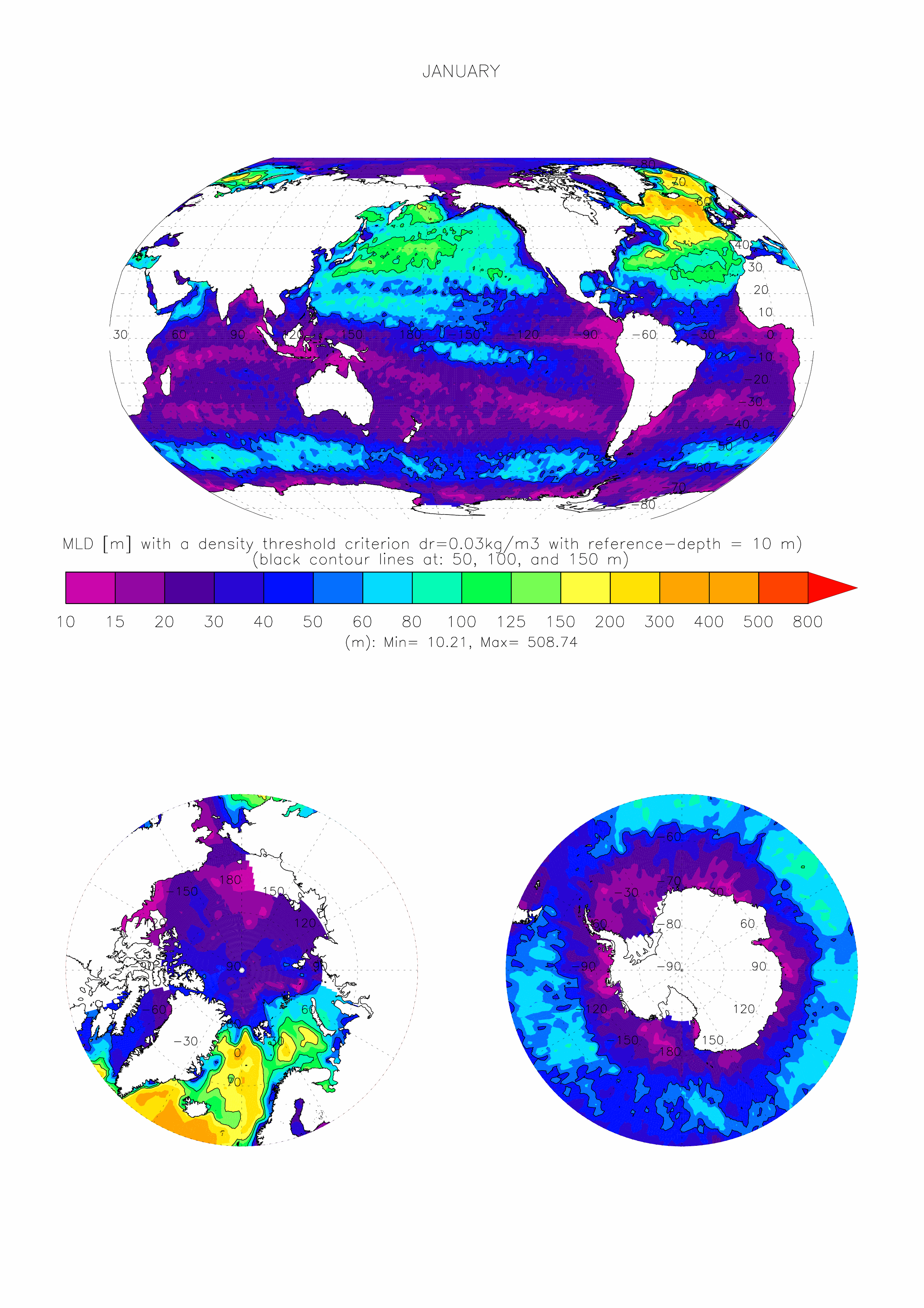
The dataset made available here is the monthly climatology (i.e. 12 months) of ocean surface Mixed Layer Depth (MLD) over the global ocean, at 1 degree x 1 degree spatial resolution. The climatology is based on about 7.3 million casts/profiles of temperature and salinity measurements made at sea between January 1970 and December 2021. Those profiles data come from the ARGO program and from the NCEI-NOAA World Ocean Database (WOD, Boyer et al. 2018). The MLD is computed on each individual cast/profile using a threshold criterion. The depth of the mixed layer is defined as the shallowest depth where the surface potential density of the profile is superior to a reference value taken close to the surface added with the chosen threshold. Here we take a threshold value for the density of 0.03kg/m3, and a surface reference depth fixed at 10m (de Boyer Montégut et al., 2004). This mixed layer is by definition homogeneous in density (up to 0.03 kg/m3 variations) and can also be called an isopycnal layer. It is especially intended for validation of MLD fields of the Ocean General Circulation Models of the ocean sciences community (e.g. Tréguier et al., 2023, Iovino et al. 2023, using v2022 of this dataset). More information and some other related datasets can be found at : https://cerweb.ifremer.fr/mld (or https://www.umr-lops.fr/en/Data/MLD redirecting to previous page).
-

The Argo program provides an unprecedented volume of oceanographic data, yet the complexity of its dataset — involving multiple data modes, quality control flags, and metadata conventions — often hinders its direct usage. The EasyOneArgo initiative addresses this challenge by delivering simplified, high-quality subsets of Argo data, specifically designed to streamline user access and integration. The EasyOneArgo data product is comprised of 4 datasets: - EasyOneArgoTS – A curated selection of temperature-salinity profiles filtered by strict quality criteria and optimized across raw, real-time adjusted, and delayed-mode status. - EasyOneArgoTSLite – The vertically interpolated counterpart of EasyOneArgoTS, with standardized pressure levels between 2 and 6000 dbar. - EasyOneArgoBGC – A curated selection of biogeochemical profiles filtered by strict quality criteria. The BGC parameters include DOXY, NITRATE, PH, CHLA, BBP, and various radiometry parameters. All BGC data are adjusted either in real-time or in delayed-mode. Accompanying TS measurements are also included. - EasyOneArgoBGCLite – The vertically interpolated counterpart of EasyOneArgoBGC, with the same standardized pressure levels as EasyOneArgoTSLite. Note: The BGC vertical interpolation process involves pre-filtering the original data before interpolation. Hence the magnitudes of some of the features are modulated in the BGCLite dataset. Each profile in EasyOneArgo is packaged as a standalone CSV file, with metadata and indexes for seamless retrieval. This work represents a user-centric shift in Argo data delivery: no QC flags, no data modes, no data manuals — just good, clean, structured ocean data ready for immediate scientific application. The EasyOneArgo data product is publicly available through monthly FAIR-compliant releases. We invite community feedback for continued refinement. Please send any comments to Annie Wong (apsw.uw@gmail.com) or Thierry Carval (Thierry.Carval@ifremer.fr).