 Catalogue PIGMA
Type of resources
Available actions
Topics
Keywords
Contact for the resource
Provided by
Years
Formats
Representation types
Update frequencies
status
Scale
Resolution
-

Extrait de l'Atlas Aquitaine, Limousin et Poitou-Charentes sur la filière forêt-bois
-

Présentation de chiffres clés de la filière forêt-bois en région Nouvelle-Aquitaine sur : - les massifs forestiers (2000-2010) - les surfaces boisées (2009-2013) - la récolte (2013/ 2014) - le sciage (2013/ 2014) - le commerce extérieur (2015) - l'emploi (2013) - la formation (2014) - la production et la commercialisation des plants forestiers (2013-2014) - le prix des bois - déstockage (pin maritime) (2008-2015) - le plan gouvernemental suite à la tempête KLAUS (2015)
-

En France et en Europe, des logos officiels permettent de reconnaître des produits qui bénéficient d'un signe officiel de la qualité et de l'origine.
-
Assessments run at AFWG provide the scientific basis for the management of cod, haddock, saithe, redfish, Greenland halibut and capelin in subareas 1 and 2. Taking the catch values provided by the Norwegian fisheries ministry for Norwegian catches1 and raising the total landed value to the total catches gives an approximate nominal first-hand landed value for the combined AFWG stocks of ca. 20 billion NOK or ca. 2 billion EUR (2018 estimates).
-
-
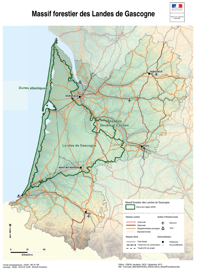
Ces travaux ont été réalisés dans le cadre de la Directive Territoriale d'Aménagement et de Développement Durable (DTADD) portée par la Préfecture de la région ex-Aquitaine. La partie I de ces travaux porte sur les valeurs du massif forestier des Landes de Gascogne. Le massif est dépositaire d’importantes valeurs et fonctions non marchandes d’intérêt général notamment : paysagères, naturalistes, hydrologiques et climatiques. Ce rapport explique également que les modes de valorisation du territoire, autres que ceux liés à la production de bois d’œuvre et d’industrie, interfèrent étroitement avec la présence même de la forêt de production : l'activité touristique, l'arrivée de nouveaux habitants et l'économie induite, ainsi que le foncier forestier.
-

-

Étude du statut juridique des voies et les conditions de leur utilisation. Plan : 1- Classification des voies 2- Voies communales 3- Chemins ruraux 4- Chemins d'exploitation 5- Chemins intérieurs
-
Description of attributes for sediment mass budget at the coast for the last 10, 50 and 100 years for the Mediterranean basin and for each NUTS3 region along the coast.
-
