 Catalogue PIGMA
North Balearic Front
Type of resources
Available actions
Topics
Keywords
Contact for the resource
Provided by
Years
Formats
-

The BioSWOT-Med campaign (Doglioli et al., 2023) was conducted aboard R/V L’Atalante from April 20 to May 15, 2023 in the Northwestern Mediterranean Sea, in the region of the North Balearic Front (NBF) to study interactions between fine-scale oceanic circulation and biogeochemical processes. Three water masses were sampled across the NBF, northern ('A'), southern ('B'), and frontal ('F'). Each Lagrangian station consisted of a 24-hour sampling period following the displacement of a water parcel (Doglioli et al., 2024). Vertical profiles down to 500 m were collected every 6 hours at 06:00 ('T1'), 12:00 ('T2'), 18:00 ('T3'), and 00:00 ('T4') UTC, for a total of 28 Lagrangian stations: first between April~24-28 (A1, F1, B1), and again between May~4-7 (B2, F2, A2), with a final station in southern waters (B3) on May~12-13. B2 and B3 stations were located inside an anticyclonic eddy. Hydrological profiles were obtained using a Sea-Bird CTD, with data averaged to a 1~m vertical resolution, they include potential temperature (°C), practical salinity, fluorescence-derived chlorophyll-a (µg/L) and oxygen (µmol/kg). Samples for nitrate + nitrite and phosphate (µM) were collected from Niskin bottles and analyzed onboard within 2-12~hours using a segmented flow analyzer (AAIII HR Seal Analytical) following (Aminot et al., 2007). Quantification limits (QL) were 0.05 µM for nitrate and 0.02 µM for phosphate. Phosphate concentrations at a nanomolar level analyses were performed in the laboratory using a high-sensitivity method combining a 1 m Liquid Waveguide Capillary Cell (LWCC) and an auto-analyzer (Zhang et al. 2002), achieving a detection limit of 0.002µM. A BGC-Argo float (WMO: 1902605 - Provor CTS4 SUNA) equipped with a CTD and SUNA nitrate sensor was deployed near station B2 and sampled the anticyclonic eddy. To better resolve the photic and nutricline layers, the standard sampling cycle was modified to a 6-hour frequency, reaching depths of 300-400~m. The BGC-Argo float nitrate dataset spans May~2-16 and includes 55~profiles, with a 0.5 µM limit of quantification. It passed through a nitrate calibration procedure against 8 ship-made profiles at B2 and B3. Data export in NetCDF format - Dataset at the 7 Lagrangian stations (28 vertical profiles for each variable, 4 at each station): ‘BioSWOT-Med_LS_Date_Time.nc’ (with day, time, longitude and latitude); ‘BioSWOT-Med_LS_Nutrients.nc’ (with nitrate, phosphate and phosphate at nanomolar level concentrations and depths); 'BioSWOT-Med_LS_CTD.nc' (with temperature in situ, practical salinity, chlorophyll-a and oxygen concentrations, photosynthetically active radiations and depth). - Dataset of the BGC-Argo float including 55 vertical profiles recorded between May 2 and 16: 'BioSWOT-Med_BGC-Argo' (with day and time, longitude, latitude; nitrate concentrations with associated depth; temperature in situ and practical salinity associated depth; chlorophyll-a concentrations with associated predepthssure; and oxygen concentrations with associated depth). Contact list Aude Joël (aude.joel@mio.osupytheas.fr), Sandra Nunige (sandra.nunige@mio.osupytheas.fr, for ship-made nutrient dataset), Riccardo Martellucci (rmartellucci@ogs.it, for the BGC-Argo float dataset) and Andrea Doglioli (andrea.doglioli@mio.osupytheas.fr, for the BioSWOT-Med cruise). References Aminot, A., & Kérouel, R. 2007. Dosage automatique des nutriments dans les eaux marines: méthodes en flux continu. Méthodes d’analyse en milieu marin. Ifremer. Doglioli, A.M., & Gregori, G. 2023. BioSWOT-Med cruise, RV L’Atalante. doi:10.17600/18002392. Doglioli, A., Grégori, G., D’Ovidio, F., Bosse, P. E., A., Carlotti, F., Lescot, M.,. . . Waggonet, E. (2024). Bioswot med. biological applicati.ons of the satellite surface water and ocean topography in the mediterranean. ref. rapport de campagne. université aix-marseille. (doi:10.13155/100060) Zhang, J.Z., & Chi, J. 2002. Automated analysis of nanomolar concentrations of phosphate in natural waters with liquid waveguide. Environ Sci Technol., 1;36(5), 1048–53. doi: 10.1021/es011094v.
-
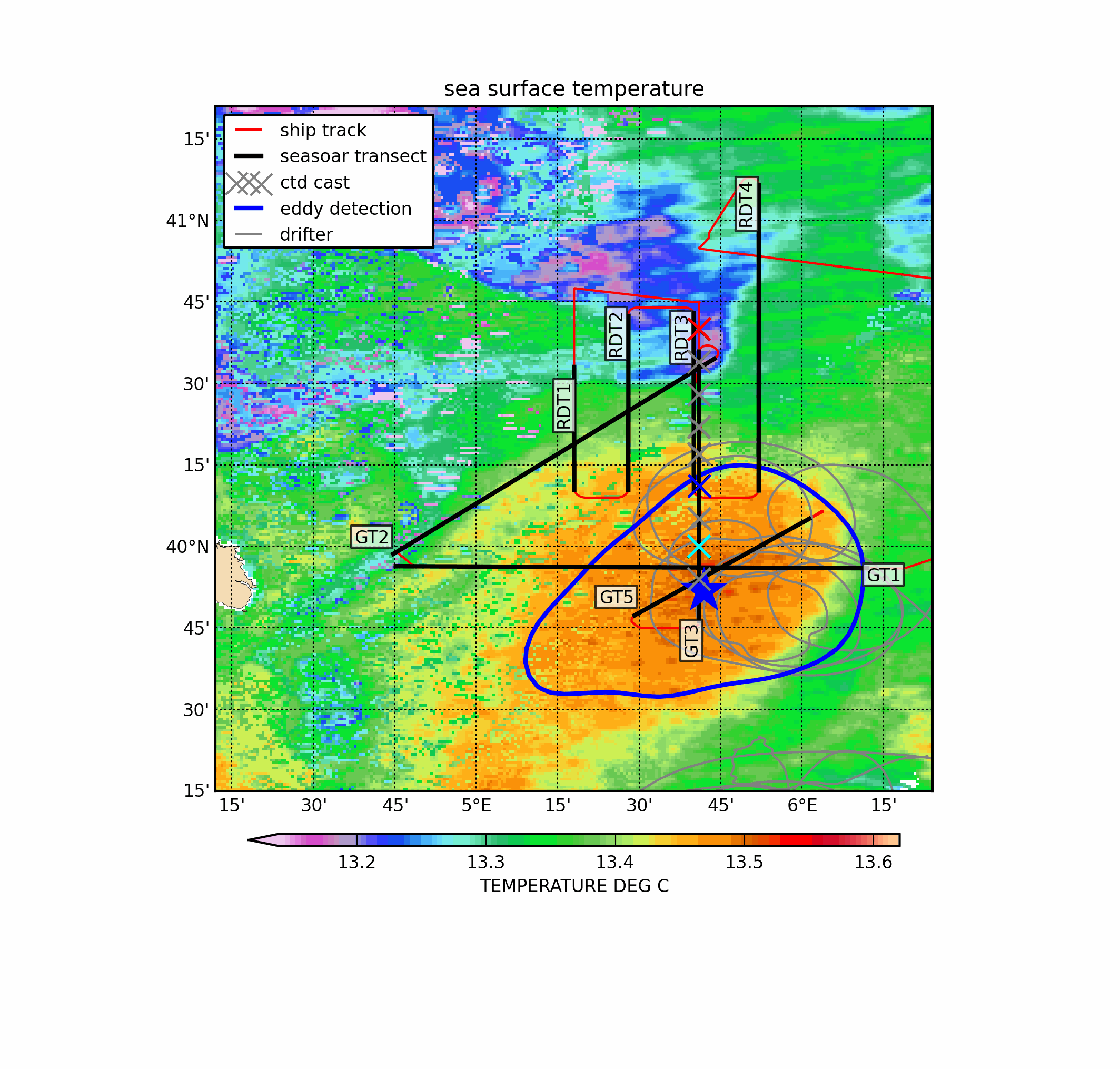
Mesoscale dynamics in the Mediterranean Sea have been investigated for years and anticyclonic eddies are regularly observed features in the Algerian Basin. In early spring 2016, a field experiment during the ProtevsMed 2016 cruise thoroughly investigated this specific eddy, when it was located near the North Balearic Front, taking high-resolution (Seasoar) hydrological transects, several CTD casts and LADCP measurements. In addition, four drifting buoys were released in the eddy core. These in situ measurements revealed that the vertical structure of this anticyclone was made of two water lenses of very different origins (Atlantic Water above and Western Intermediate Water below) spinning together. In the vicinity of the North Balearic Front, which may act as a dynamical barrier for structures, the eddy interacted with a subsurface anticyclonic eddy made of modal water, which fostered cross-front exchanges generating filaments by stirring. The high-resolution sampling revealed fine scales structures both adjacent to the eddy and within its core. The eddy has been targeted from 21 March to 1 April 2016 taking advantage of a meteorological window. It has been sampled with: - a towed undulating vehicle, the SeaSoar designed and built by Chelsea Instruments; it gets mounted on its sides two Sea-bird SBE-9 (SBE 3 temperature and SBE 4 conductivity sensors) and a Wetlabs Fluorometer of type ChloroA WetStar - CTD casts performed with a Sea-bird SBE-9 (SBE 3 temperature and SBE 4 conductivity sensor) and an RDI 150 kHz current profiler mounted in a general oceanics 12-place rosette, with12l Niskin bottles - drifters with holey-sock positioned at 50 m deep below the expected Ekman layer thickness (remaining in the eddy until mid May).