 Catalogue PIGMA
500000
Type of resources
Available actions
Topics
Keywords
Contact for the resource
Provided by
Years
Formats
Representation types
Update frequencies
status
Scale
Resolution
-

Sea bed sediment maps for the 4 marine sub-regions prepared as part of the initial evaluation of the MSFD (Marine Strategy Framework Directive).
-

Les périmètres des quartiers prioritaires de la politique de la ville sont fixés par le décret n° 2014-1750 du 30 décembre 2014 pour la métropole et par le décret n° 2014-1751 du 30 décembre 2014 pour les départements et collectivités d’outre-mer, rectifiés par le décret n°2015-1138 du 14 septembre 2015.
-
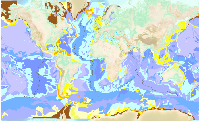
The “World Seabed Sediment Map” product contains geo-referenced digital data, describing the nature of the sediment encountered in different seas and oceans of the world. The objects are all surface areas and the description of an object includes in particular the nature of the sediment including rock-type bottoms.
-
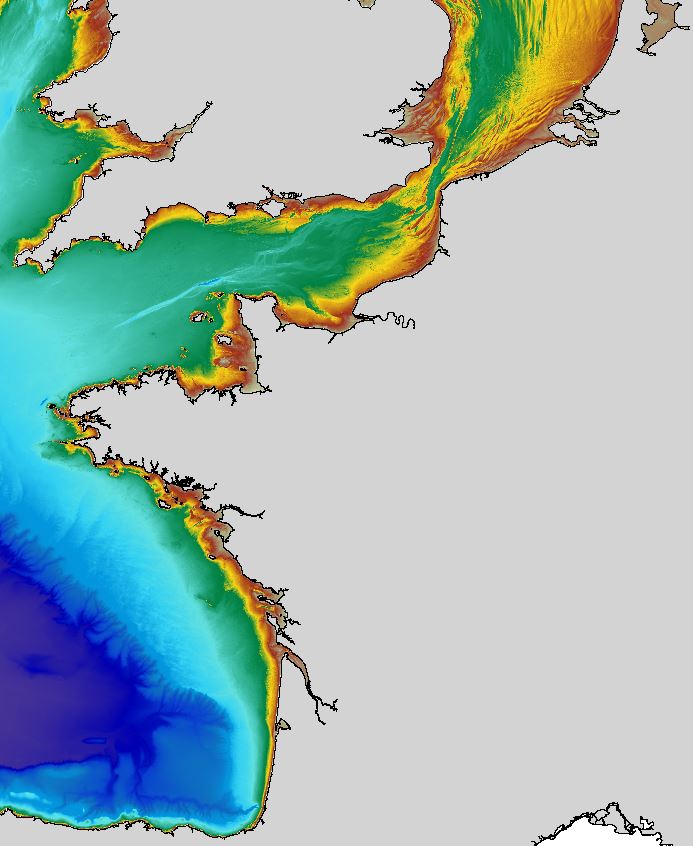
The regional bathymetric Atlantic – Channel – North-Sea DTM has a resolution of 0.001° (~111m). Its geographic coverage includes the Bay of Biscay, the English Channel and a part of the North Sea. The DTM extends from the coast to the continental slope (about of 4800m deep). This DTM is produced in the framework of the HOMONIM project which aims at improving operational forecast capabilities for the national coastal flood warning system. This DTM is offered openly on the Shom diffusion website (http://diffusion.shom.fr/produits/bathymetrie/mnt-facade-atl-homonim.html). http://dx.doi.org/10.17183/MNT_ATL100m_HOMONIM_WGS84
-

Carte de géomorphologie à 1 : 500 000 produite par la France dans le cadre du work-package 4 (géologie du fond marin / géomorphologie) du projet européen EMODnet Geology, à l'intérieur de la ZEE métropolitaine française. Cette version du jeu de données correspond à la phase IV du projet.
-
Pour gérer les données d'observation et de surveillance du littoral, l'Ifremer a développé le système d'information Quadrige, qui associe à une base de données une panoplie d'outils d'interprétation et d'élaboration de produits d'information. Quadrige² est aujourd'hui désigné par le ministère de l'environnement comme le système d’information de référence pour les eaux littorales. Pour ce faire, le système est conçu dès l’origine pour être largement ouvert vers nos partenaires et constitue un élément du Système d'Information sur l'Eau (SIE). Dans ce cadre, le système s’appuie sur différents référentiels, qui pour l’essentiel sont des référentiels nationaux, partagés par l’ensemble des acteurs de l’eau et à ce titre, contribue aux travaux du Secrétariat d'Administration National des Données Relatives à l'Eau (SANDRE). Désormais, ce système contribue aussi aux travaux du Service d’Administration des Référentiels (SAR) du Système d’Information sur le Milieu Marin (SIMM). La banque Quadrige est constituée des données de la base Quadrige et des produits décrits ou mis à disposition sur le site Envlit. La base Quadrige contient des résultats sur des paramètres physiques, chimiques et biologiques de description de l'environnement marin et de la ressource conchylicole. Les premières données datent de 1973 pour les paramètres de la qualité générale des eaux et les contaminants, 1974 pour le phytoplancton et les phycotoxines, 1987 pour la microbiologie. Elles sont mises à jour en permanence.
-

Cartographie de la répartition territoriale des logements subventionnés par l'ANAH (Agence Nationale pour l'Amélioration de l'Habitat) selon que les propriétaires soient Occupants (PO) ou Bailleurs (PB)
-

Observations marines et sous-marins de l'état des paysages sous marins et des pressions
-
Jeu de données vectorielles correspondant à la "Carte des sédiments superficiels du plateau continental du golfe de Gascogne - partie septentrionale". Echelle 1/500000. Carte réalisée conjointement par le BRGM et l'Ifremer, en 1986. Indications figurant sur la carte d'origine : "Maquette réalisée avec le concours financier du Bureau de Recherches Géologiques et Minières, sous la responsabilité scientifique de André KLINGEBIEL de l'Institut de Géologie du Bassin d'Aquitaine (Université de Bordeaux I). Document établi par Patrick LESUEUR et André KLINGEBIEL, d'après les reconnaissances et les résultats de prélèvements et d'analyses obtenus te/ou communiqués par : - la Banque de Données de Géologie Marine (BRGM, Centre de Brest de l'Ifremer), - le Service de Documentation de l'Institut de Géologie du Bassin d'Aquitaine, - Philippe BOUYSSE (Bureau de Recherches Géologiques et Minières, Orléans), - Didier DOREL (Institut Scientifique et Technique des Pêches Maritimes, Nantes, maintenant Ifremer), - Jean-Pierre PINOT (Université de Bretagne Occidentale, Brest), - Jean-René VANNEY (Institut de Géographie et Université Pierre et Marie Curie, Paris), - Jean-Paul BARUSSEAU (Université de Perpignan), - François OTTMANN et Yann DELANOE (Université de Nantes), et en tenant compte des documents antérieurement édités : - Atlas des fonds meubles du plateau continental du golfe de Gascogne : cartes biosédimentaires, de Claude CHASSE et Michel GLEMARREC, - Cartes sédimentologiques sous-marines des côtes de France au 1/100 000 : n°7 (Pont-Croix); n°9 (Lorient); n°10 (St-Nazaire); n°11 (Ile d'Yeu). L'édition de la carte a été coordonnée par Philippe BOUYSSE."
-
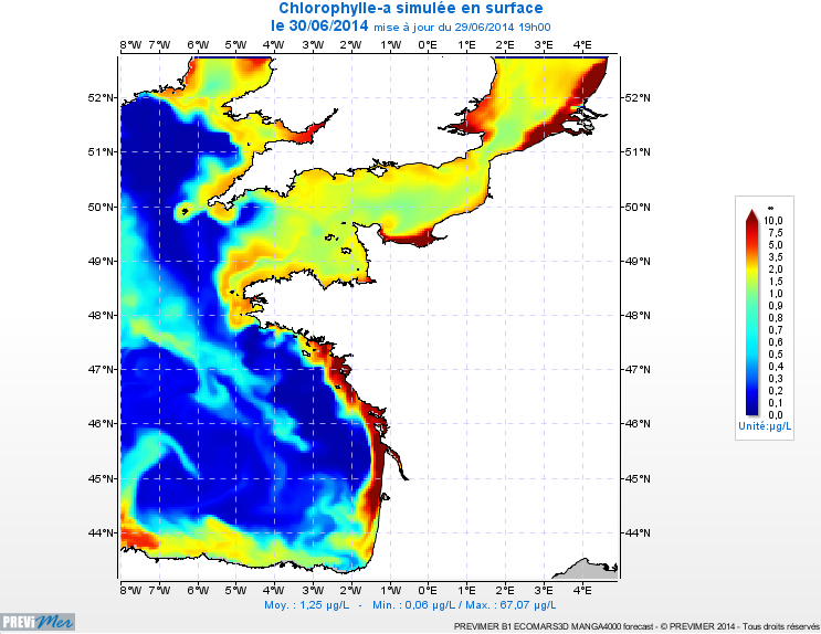
PREVIMER_B1-ECOMARS3D-MANGA4000 est un modèle 3D de résolution spatiale 4km qui fournit les concentrations de nutriments et de plancton toutes les heures sur 30 niveaux (fenêtre de prévision à 4 jours).