 Catalogue PIGMA
satellite altimetry
Type of resources
Available actions
Topics
Keywords
Contact for the resource
Provided by
Years
Formats
Representation types
-
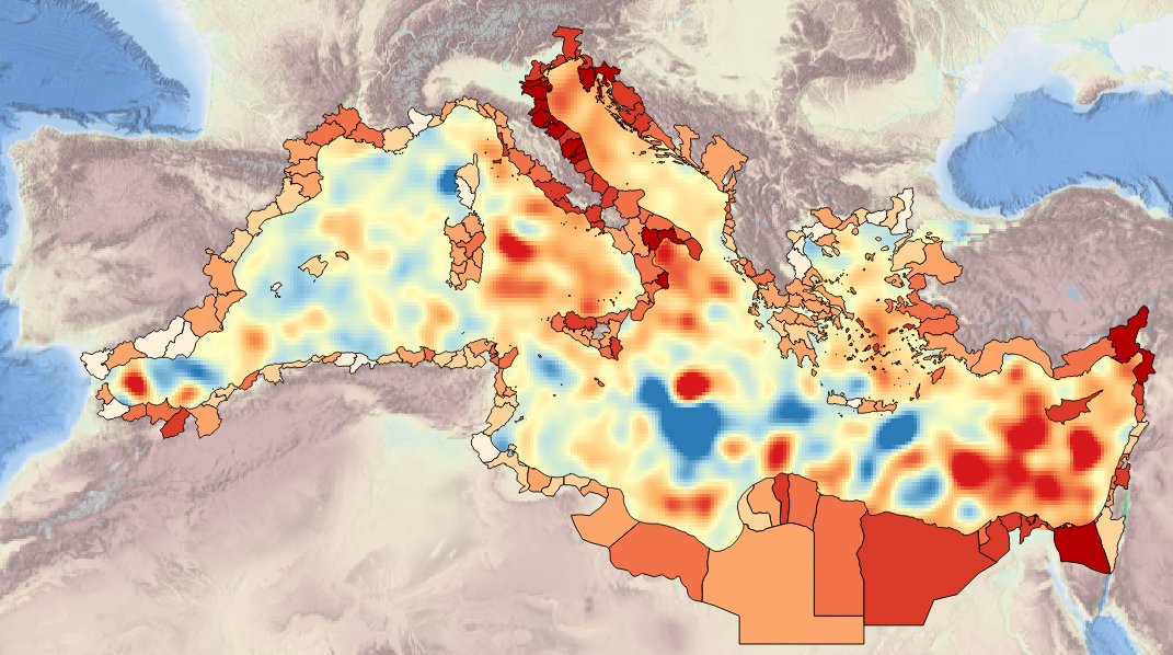
Description ot the spatial layers attributes of sea level trend for the last 10 years for the Mediterranean basin and for each NUTS3 region along the coast.
-
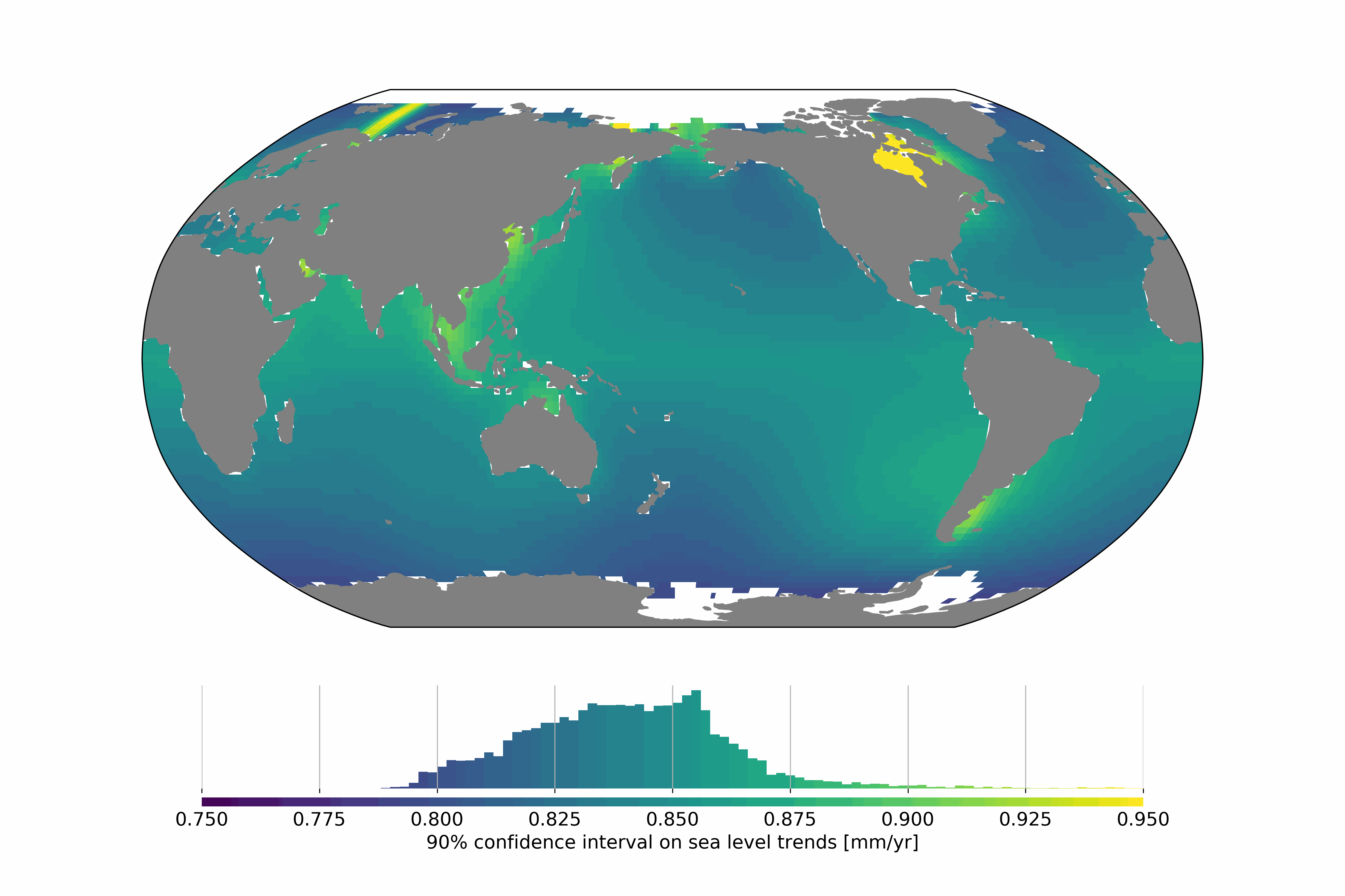
Satellite altimetry missions provide a quasi-global synoptic view of sea level over more than 25 years. The satellite altimetry constellation is used to build sea level maps and regional sea level indicators such as trends and accelerations. Estimating realistic uncertainties on these quantities is crucial to address some current climate science questions such as climate change detection and attribution or regional sea level budget closure for example. Previous studies have estimated the uncertainty for the global mean sea level (GMSL), but no uncertainty information is available at regional scales. In this study we estimate a regional satellite altimetry error budget and use it to derive maps of confidence intervals for local sea rise rates and accelerations. We analyze 27 years of satellite altimetry maps and derive the satellite altimetry error variance-covariance matrix at each grid point, prior to the estimation of confidence intervals on local trends and accelerations at the 90% confidence level using extended least squares estimators. Over 1993–2019, we find that the average local sea level trend uncertainty is 0.83 mm.yr-1 with local values ranging from 0.78 to 1.22 mm.yr-1. For accelerations, uncertainties range from 0.057 to 0.12 mm.yr-2, with a mean value of 0.063 mm.yr-2. Change history: - 2020/07/08: initial dataset submission over 1993-2018 - 2020/10/21: 1993-2019 update and addition of error levels
-

Description of attributes for time series of sea level trend for the last 10 yrs for the Mediterranean basin and for each NUTS3 region along the coast.
-

This dataset contains mesoscale eddies from the Ocean Eddy Detection and Tracking Algorithms (TOEddies) Atlas colocated with Argo profiling floats. Applied to daily gridded maps of satellite Absolute Dynamic Topography, TOEddies provides information on eddy dynamical characteristics (e.g., size and intensity) over a 30+ year period (1993–2023) and identifies complex eddy-eddy interactions that lead to eddy splitting and merging. Furthermore, these eddies are combined with 23 years of Argo profile co-located measurements (2000–2023), enabling investigation into the signature of eddies and their impact in the ocean interior. This dataset contains eddies detected across the entire geographical area covered by altimetric maps. Special caution is advised for studies focusing on eddies near the equator, where geostrophic balance breaks down, and at high latitudes, where the small Rossby radius limits detection capabilities in 1/4° altimetric fields. TOEddies, based on the method proposed and developed by Chaigneau et al. (2008, 2011) and Pegliasco et al. (2018), was first presented in Laxenaire et al. (2018) when applied to the South Atlantic Ocean. To date, approximately 20 peer-reviewed publications have employed the TOEddies algorithm (see Ioannou et al., Preprint 2024 for a recent list of some of them). Notably, mesoscale eddies from TOEddies, following Chaigneau et al. (2011), have been colocated with Argo floats, facilitating, for example, the identification of the transition from surface to subsurface intensified eddies (Laxenaire et al., 2019), the estimation of heat transport by eddies (Laxenaire et al., 2020), and the study of the impact of mesoscale eddies on Deep Chlorophyll Maxima with BGC Argo floats (Cornec et al., 2021). The V1 version of this dataset is described in detail in the appendix of Ioannou et al. (Preprint 2024) and compared to other eddy detection datasets in the core text of Ioannou et al. (Preprint 2024). Input Fields => Satellite Altimetry: Daily all-satellite sea surface height fields produced by Copernicus Marine Service (https://marine.copernicus.eu/fr). This multi-satellite product integrates data from all available satellites at a given time and is projected onto a fixed grid with a resolution of 0.25°, covering the global ocean (version: cmems_obs-sl_glo_phy-ssh_my_allsat-l4-duacs-0.25deg_P1D, DOI:10.48670/moi-00148). Argo Floats: Argo float profile data and positions were retrieved from the Ifremer FTP (Argo, 2024; DOI:10.17882/42182). See Detection eddies repository for technical guidance on this dataset.