 Catalogue PIGMA
TAR
Type of resources
Available actions
Topics
Keywords
Contact for the resource
Provided by
Years
Formats
-

Plankton was imaged with the PlanktoScope in different oceanic regions using different nets and protocol of conservation. This dataset aims to serve as reference for taxonomic identification with the PlanktoScope across 256 plankton taxa from 20µm to 300µm. Reference dataset can also serve as learning set for prediction in Ecotaxa (https://ecotaxa.obs-vlfr.fr/prj/15535). The full images were processed and segmented with the PlanktoScope around each individual. A set of associated features were measured on the objects with skimage.measure. All objects were classified into 256 different classes using the web application EcoTaxa (http://ecotaxa.obs-vlfr.fr). The following dataset corresponds to the 169, 149 objects and their calculated features. The different files provide information about the features of the objects, their taxonomic identification as well as the raw images. taxa.csv.gz Table of the classification of each object in the dataset, with columns: - object_id: unique object identifier in EcoTaxa. - annotation_category: taxonomic name corresponding to the last level of hierarchy - annotation_hierarchy: taxonomic lineage to the category - set: class of the image corresponding to the taxon - img_file_name: local path of the image corresponding to the taxon, named according to the object id features_native.csv.gz Table of morphological features computed by PlanktoScope. All features are computed on the object only, not the background. All area/length measures are in pixels. - object_id: unique object identifier in Ecotaxa And 33 features: - width: width of the smallest rectangle enclosing the object (pixel) - height: height of the smallest rectangle enclosing the object (pixel) - bx: X coordinates of the top left point of the smallest rectangle enclosing the object (pixel) - by: Y coordinates of the top left point of the smallest rectangle enclosing the object (pixel) - circ.: circularity of the object ((4∗π ∗Area)/Perim^2) [0-1] - area_exc: Surface area of the object excluding holes (pixel2) - area: Surface area of the object (pixel2) - %area: Percentage of object’s surface area that is comprised of holes - major: Length of the primary axis of the best fitting ellipse for the object (pixel) - minor: Length of the secondary axis of the best fitting ellipse for the object (pixel) - y: Y position of the center of gravity of the object (pixel) - x: X position of the center of gravity of the object (pixel) - convex_area: The area of the smallest polygon within which all points in the object fit (pixel2) - perim.: The length of the outside boundary of the object (pixel) - elongation: elongation index (major/minor) - perimareaexc: index of the relative complexity of the perimeter (perim/area_exc) - perimmajor: Index of the relative complexity of the perimeter (perim/major) - circex: Circularity of object excluding white pixels ((4 ∗ π ∗ Area_exc)/perim 2) - angle: Angle between the primary axis and a line parallel to the x-axis of the image - bounding_box_area: Area of the smallest box containing the object (pixel2) - eccentricity: Eccentricity of the ellipse that has the same second-moments as the region. Ratio of the focal distance of the ellipse over the major axis length [0-1] - equivalent_diameter: The diameter of a circle with the same area as the object (pixel) - euler_number: Euler characteristic of the set of non-zero pixels. Computed as number of connected components subtracted by number of holes - extent: Ratio of pixels in the object to pixels in the total bounding box - local_centroid_col: Horizontal coordinate of the center of mass of the object (pixel) - local_centroid_row: Vertical coordinate of the center of mass of the object (pixel) - solidity: Ratio of pixels in the object to pixels of the convex hull image (area / convex_area) - meanhue: Mean base color of the object in hue scale (0-360) - meansaturation: Mean saturation of the object [0-100] - meanvalue: Mean brightness of the object [0-100] - stdhue: Standard deviation of base color - stdsaturation: Standard deviation of saturation - stdvalue: Standard deviation of brightness inventory.tsv Tree view of the taxonomy and number of images in each taxon, displayed as text. With columns : - annotation_hierarchy: taxonomic lineage - annotation_category: name of the taxon - n: number of objects in each taxon group map.png Map of the sampling locations, to give an idea of the diversity sampled in this dataset. imgs Directory containing images of each object, named according to the object id object_id and sorted in subdirectories according to their taxon.
-

Plankton was sampled with a Continuous Underway Fish Egg Sampler (CUFES, 315µm mesh size) at 4 m below the surface, and a WP2 net (200µm mesh size) from 100m to the surface, or 5 m above the sea floor to the surface when the depth was < 100 m, in the Bay of Biscay. The full images were processed with the ZooCAM software and the embedded Matrox Imaging Library (Colas et a., 2018) which generated regions of interest (ROIs) around each individual object and a set of features measured on the object. The same objects were re-processed to compute features with the scikit-image library http://scikit-image.org. The 1, 286, 590 resulting objects were sorted by a limited number of operators, following a common taxonomic guide, into 93 taxa, using the web application EcoTaxa http://ecotaxa.obs-vlfr.fr. For the purpose of training machine learning classifiers, the images in each class were split into training, validation, and test sets, with proportions 70%, 15% and 15%. The archive contains : taxa.csv.gz Table of the classification of each object in the dataset, with columns : - objid : unique object identifier in EcoTaxa (integer number). - taxon_level1 : taxonomic name corresponding to the level 1 classification - lineage_level1 : taxonomic lineage corresponding to the level 1 classification - taxon_level2 : name of the taxon corresponding to the level 2 classification - plankton : if the object is a plankton or not (boolean) - set : class of the image corresponding to the taxon (train : training, val : validation, or test) - img_path : local path of the image corresponding to the taxon (of level 1), named according to the object id features_native.csv.gz Table of morphological features computed by ZooCAM. All features are computed on the object only, not the background. All area/length measures are in pixels. All grey levels are in encoded in 8 bits (0=black, 255=white). With columns : - area : object's surface - area_exc : object surface excluding white pixels - area_based_diameter : object's Area Based Diameter: 2 * (object_area/pi)^(1/2) - meangreyobjet : mean image grey level - modegreyobjet : modal object grey level - sigmagrey : object grey level standard deviation - mingrey : minimum object grey level - maxgrey : maximum object grey level - sumgrey : object grey level integrated density: object_mean*object_area - breadth : breadth of the object along the best fitting ellipsoid minor axis - length : breadth of the object along the best fitting ellipsoid majorr axis - elongation : elongation index: object_length/object_breadth - perim : object's perimeter - minferetdiam : minimum object's feret diameter - maxferetdiam : maximum object's feret diameter - meanferetdiam : average object's feret diameter - feretelongation : elongation index: object_maxferetdiam/object_minferetdiam - compactness : Isoperimetric quotient: the ration of the object's area to the area of a circle having the same perimeter - intercept0, intercept45 , intercept90, intercept135 : the number of times that a transition from background to foreground occurs a the angle 0ø, 45ø, 90ø and 135ø for the entire object - convexhullarea : area of the convex hull of the object - convexhullfillratio : ratio object_area/convexhullarea - convexperimeter : perimeter of the convex hull of the object - n_number_of_runs : number of horizontal strings of consecutive foreground pixels in the object - n_chained_pixels : number of chained pixels in the object - n_convex_hull_points : number of summits of the object's convex hull polygon - n_number_of_holes : number of holes (as closed white pixel area) in the object - roughness : measure of small scale variations of amplitude in the object's grey levels - rectangularity : ratio of the object's area over its best bounding rectangle's area - skewness : skewness of the object's grey level distribution - kurtosis : kurtosis of the object's grey level distribution - fractal_box : fractal dimension of the object's perimeter - hist25, hist50, hist75 : grey level value at quantile 0.25, 0.5 and 0.75 of the object's grey levels normalized cumulative histogram - valhist25, valhist50, valhist75 : sum of grey levels at quantile 0.25, 0.5 and 0.75 of the object's grey levels normalized cumulative histogram - nobj25, nobj50, nobj75 : number of objects after thresholding at the object_valhist25, object_valhist50 and object_valhist75 grey level - symetrieh :index of horizontal symmetry - symetriev : index of vertical symmetry - skelarea : area of the object skeleton - thick_r : maximum object's thickness/mean object's thickness - cdist : distance between the mass and the grey level object's centroids features_skimage.csv.gz Table of morphological features recomputed with skimage.measure.regionprops on the ROIs produced by ZooCAM. See http://scikit-image.org/docs/dev/api/skimage.measure.html#skimage.measure.regionprops for documentation. inventory.tsv Tree view of the taxonomy and number of images in each taxon, displayed as text. With columns : - lineage_level1 : taxonomic lineage corresponding to the level 1 classification - taxon_level1 : name of the taxon corresponding to the level 1 classification - n : number of objects in each taxon group map.png Map of the sampling locations, to give an idea of the diversity sampled in this dataset. imgs Directory containing images of each object, named according to the object id objid and sorted in subdirectories according to their taxon.
-
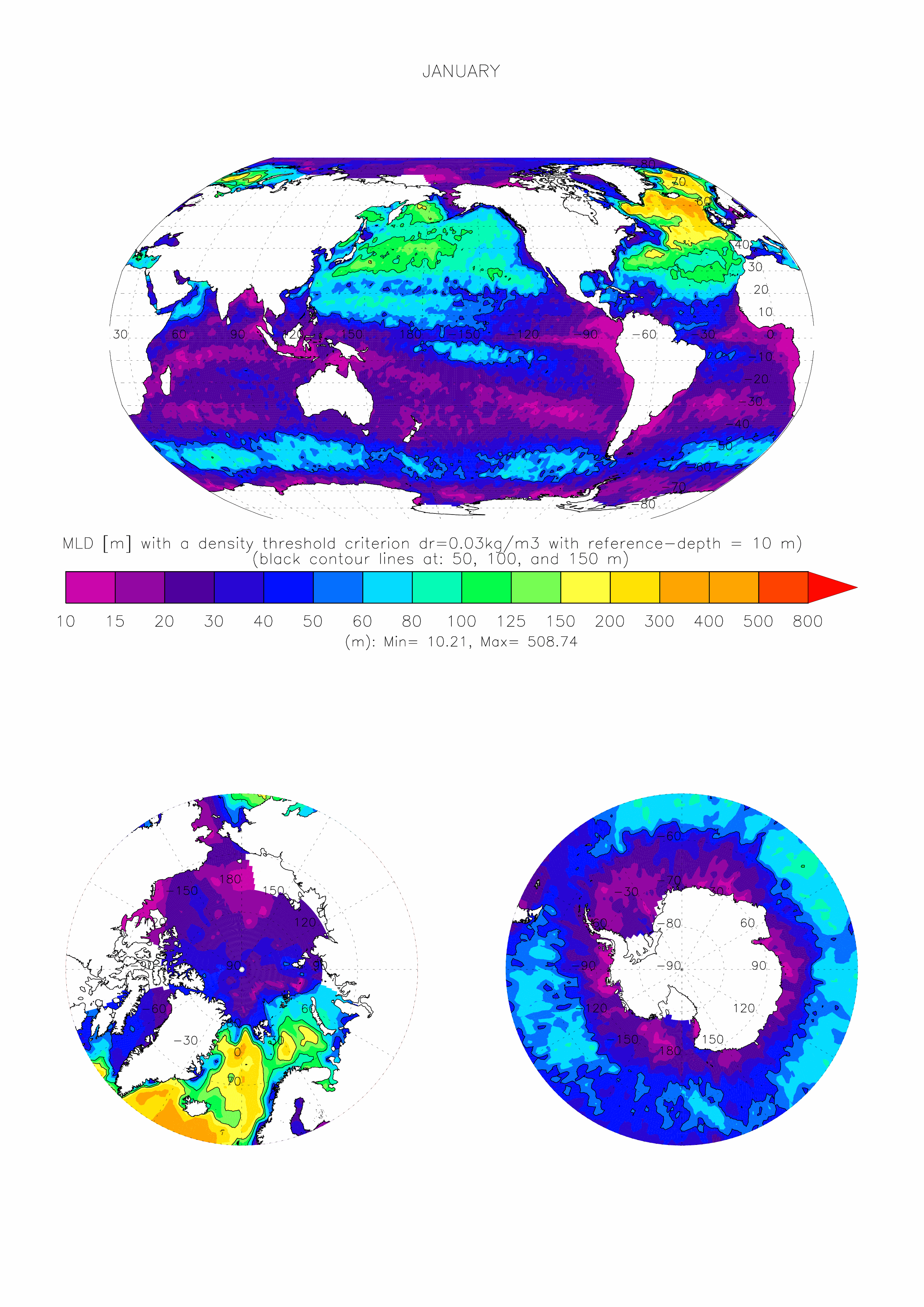
The dataset made available here is the monthly climatology (i.e. 12 months) of ocean surface Mixed Layer Depth (MLD) over the global ocean, at 1 degree x 1 degree spatial resolution. The climatology is based on about 7.3 million casts/profiles of temperature and salinity measurements made at sea between January 1970 and December 2021. Those profiles data come from the ARGO program and from the NCEI-NOAA World Ocean Database (WOD, Boyer et al. 2018). The MLD is computed on each individual cast/profile using a threshold criterion. The depth of the mixed layer is defined as the shallowest depth where the surface potential density of the profile is superior to a reference value taken close to the surface added with the chosen threshold. Here we take a threshold value for the density of 0.03kg/m3, and a surface reference depth fixed at 10m (de Boyer Montégut et al., 2004). This mixed layer is by definition homogeneous in density (up to 0.03 kg/m3 variations) and can also be called an isopycnal layer. It is especially intended for validation of MLD fields of the Ocean General Circulation Models of the ocean sciences community (e.g. Tréguier et al., 2023, Iovino et al. 2023, using v2022 of this dataset). More information and some other related datasets can be found at : https://cerweb.ifremer.fr/mld (or https://www.umr-lops.fr/en/Data/MLD redirecting to previous page).