 Catalogue PIGMA
XLS, XLSX
Type of resources
Available actions
Topics
Keywords
Contact for the resource
Provided by
Years
Formats
-

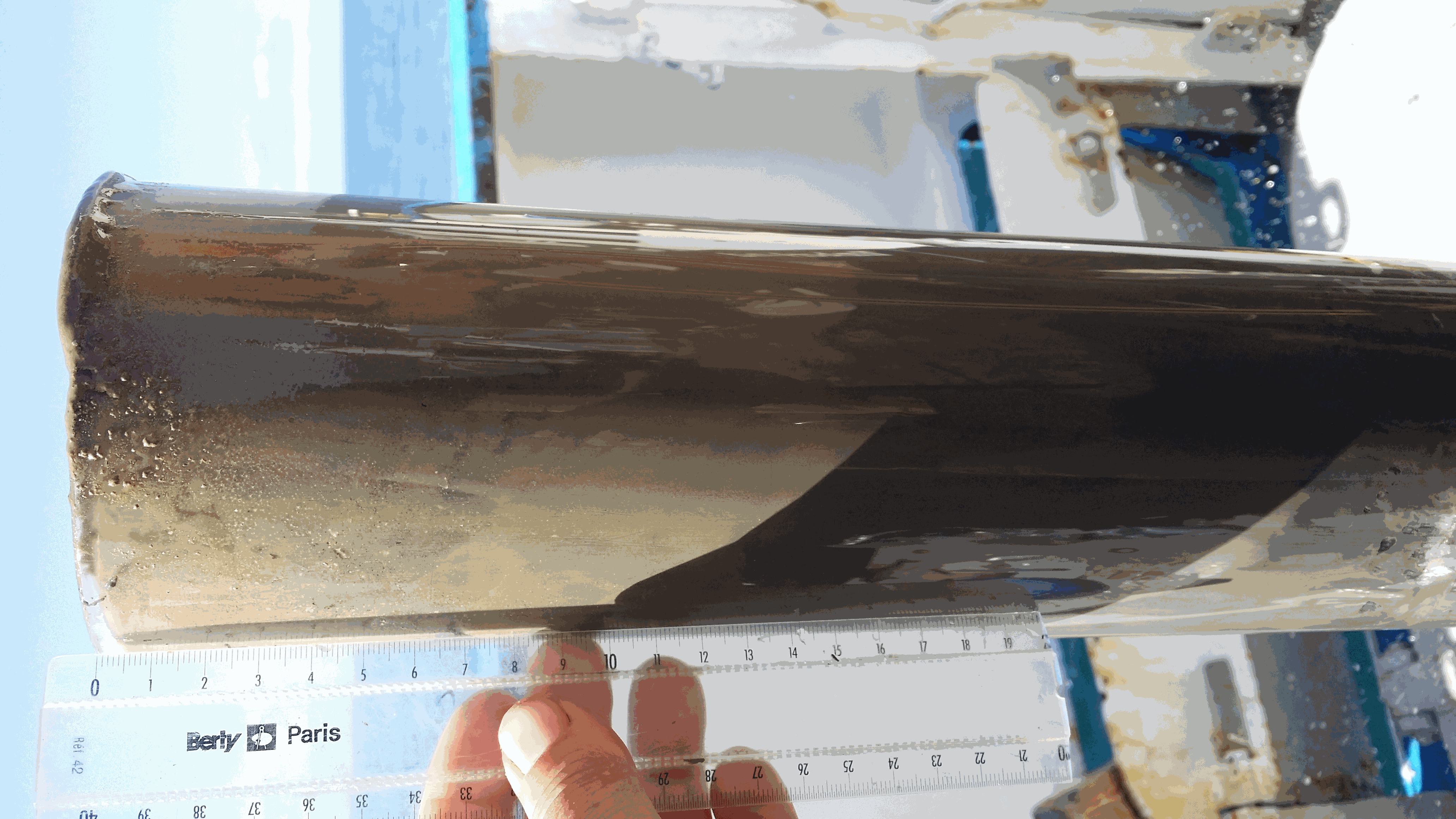
This set of data documents the radiocarbon dates (n=19) obtained thanks to the accelerator mass spectrometry method (AMS) at the LMC14/ARTEMIS French national facility on the cores (Multicorer, Kullenberg) retrieved from the West-Gironde mud patch (WGMP) during the JERICObent-7 cruise (10-15 July 2019; NR Côtes de la Manche, https://doi.org/10.17600/18001022). The WGMP registers very high sedimentation rates since the last 600 years (≥ 0.3 cm/yr) and is thus of great interest for palaeoceanographic investigations. At present, this depocenter marks the mid-shelf of the temperate Bay of Biscay off major French rivers from the Aquitaine basin. The fine mud deposits of the WGMP are of 3 to 4 meters thick and lie on palimpsest levels rich in gravels and shells. They cover a V-shaped structure, oriented SW-NE, which is attributed to the incision(s) of a paleovalley in the Cenozoic substrate, mainly linked to the paleo-Gironde routing changes during past glacials/interglacials, and its potential past convergences with the paleo-rivers of the Antioche perthuis (Seudre, Charente paleovalleys?) at that times. Detailed information on each sample is presented with the 14C results obtained by the Artemis AMS facility at LMC14 laboratory (Dumoulin et al. 2017- https://doi.org/10.1017/RDC.2016.116, Beck et al. 2024- https://doi.org/10.1017/RDC.2023.23). Raw ages are indicated together with calibration calculations using the last two versions of the Calib software (http://calib.org/, Calib 7 and 8) to show the dispersion of ages linked to the updating of calibration curves (Marine13, Intcal13, Marine20, Intcal 20). The calibrated ages finally retained for publications (used in the related Seanoe document - https://doi.org/10.17882/104237 - and published in Eynaud et al., 2025 for the ST3c core, https://doi.org/10.1016/j.gloplacha.2025.105039) are those obtained with the last Calib 8.1 version. Raw 14C ages were calibrated and converted to calendar ages using the IntCal20 calibration curve with a reservoir age correction of 400 years deduced from Radionuclide analyses (137Cs and 210Pb) at the top of the studied cores (see Schmidt, 2025, https://www.seanoe.org/data/00968/107979/).
-
Key physico-chemical parameters (salinity, temperature, turbidity and dissolved oxygen) were measured in surface water during longitudinal transects in the Loire and Gironde estuaries in summers 2017 and 2018. This objective of this work was to determine the distribution of the dissolved oxygen and to detect potential severe desoxygenation. The transects were scheduled in order to begin the measurements at high tide from a site located upstream of an area where severe deoxygenation have been already been reported. Then, the transect was realised by sailing at low speed downstream with a multiparameter probe SAMBAT, maintained at 0.5 m below the surface, that collected a measurement every 2 minutes.
-
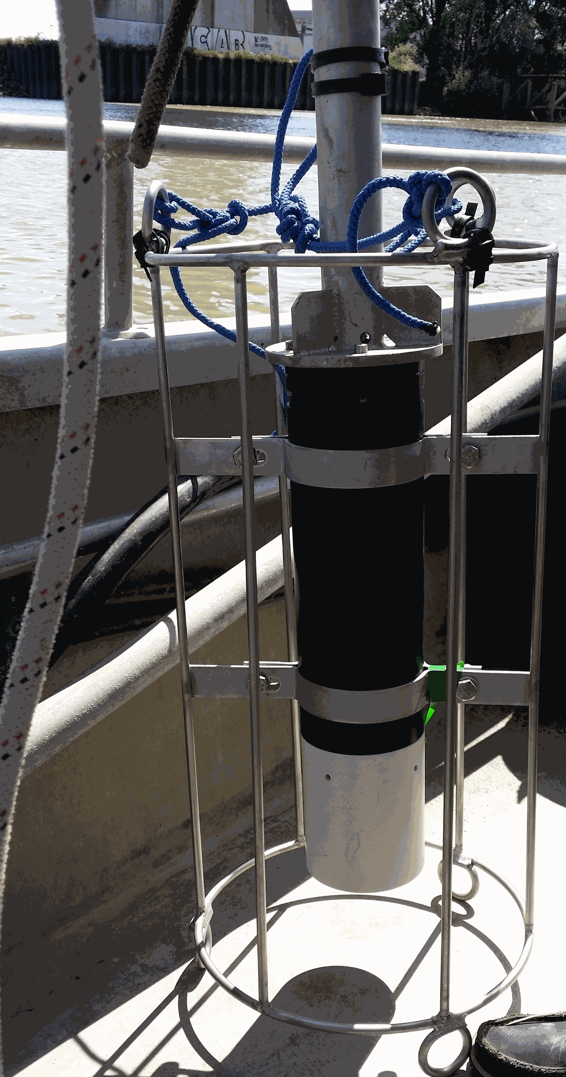
The West Gironde Mud Patch (WGMP) is a 420-km2 mud belt in the Bay of Biscay, located 25 km off the mouth of the Gironde estuary. This clay-silt feature of 4 m in thickness extends between 30 and 75m water depth, surrounded by the sands and gravels that cover the North Aquitaine continental shelf. Interface cores were collected during JERICOBent-1 cruise (October 2016; Deflandre (2016) doi.org/10.17600/16010400) along two cross-shelf transects for a total of 9 sites. Each sediment core was carefully extruded every 0.5 cm from the top core to 4 cm and every 1 cm below until the core bottom. The sediment layers were used to determine dry bulk density, grain size and selected radioisotope activities (210Pb, 226Ra, 137Cs, 228Th, K).
-

As part of the European Horizon Europe FOCCUS project (https://foccus-project.eu/), the metadata inventory of European coastal platforms has been extracted. The inventory was based on the following History and Latest products, downloaded from the CMEMS website (https://marine.copernicus.eu/fr/acces-donnees) at: 1) Global Ocean-In-Situ Near-Real-Time Observation, 2) Atlantic Iberian Biscay Irish Ocean-In-Situ Near Real Time Observations, 3) Mediterranean Sea-In-Situ Near Real Time Observations, 4) Atlantic-European North West Shelf-Ocean In-Situ Near Real Time Observations. To carry out this inventory, it was decided to target only coastal platforms, located less than 200km from the coast and at a depth of less than 400m. For mobile platforms, it was also decided to focus only on the first position in the file. This data must be located within 200 km of the coast and at a depth of less than 400 m. In this inventory, FerryBox platforms have all been considered as coastal platforms. The following platforms were extracted from the products: BO (Bottles), CT (CTD), DB (Drifting Buoys), FB (Ferry Box), GL (Gliders), HF (High Frequency Radar), MO (Mooring), PF (Profiling Float), TG (Tide Gauge) and XB (XBT). Once the metadata had been extracted from the files, duplicates were removed (files with the same names). Duplicate platforms of type _TS_ and _WS_ were merged (date and parameters). Latest‘ files have been merged with ’History" files. Missing metadata have been replaced in the Excel file by ‘Missing Data’. Some old dates were also revised by hand because they had been badly extracted, as well as some institution names that included special characters. Platforms located on estuaries/rivers/lakes/ponds have also been removed by hand. This inventory identified a total of 10,479 coastal platforms.
-
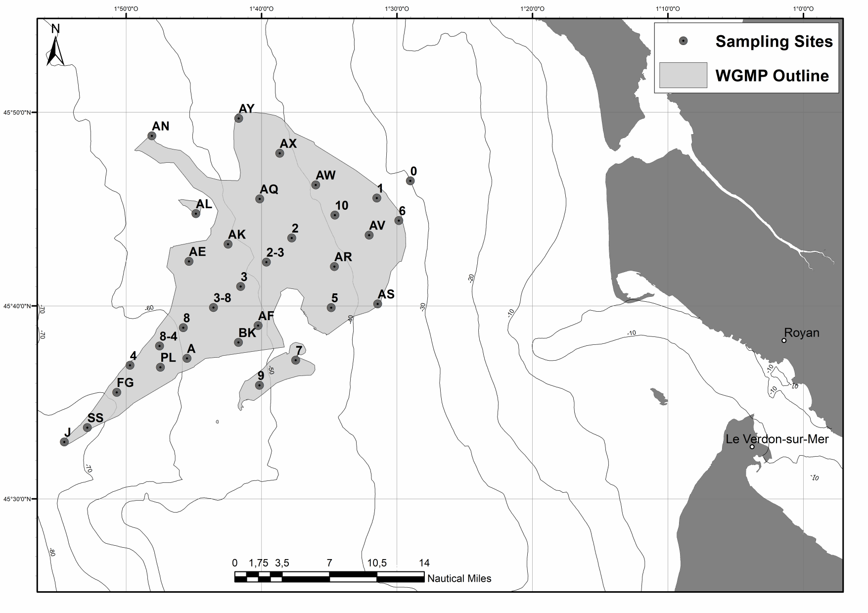
The spatial distributions of (1) surface sediment characteristics (D0.5, Sediment Surface Area (SSA), Particulate Organic Carbon (POC), Chlorophyll-a (Chl-a), Phaeophytin-a (Phaeo-a), Total and Enzymatically Hydrolyzable Amino Acids (THAA, EHAA), δ13C) and (2) sediment profile image (apparent Redox Potential Discontinuity (aRPD), numbers and depths of biological traces) characteristics were quantified based on the sampling of 32 stations located within the West Gironde Mud Patch (Bay of Biscay, NE Atlantic) in view of (1) assessing the spatial structuration of a temperate river-dominated ocean margin located in a high-energy area, (2) disentangling the impacts of hydrodynamics and bottom trawling on this structuration, and (3) comparing the West Gironde Mud Patch with the Rhône River Prodelta (located in a low-energy area). Results support the subdivision of the West Gironde Mud Patch in a proximal and a distal part and show (1) the existence of depth gradients in surface sedimentary organics characteristics and bioturbation within the distal part; (2) no evidence for a significant effect of bottom trawling, as opposed to Bottom Shear Stress, on the West Gironde Mud Patch spatial structuration; and (3) major discrepancies between spatial structuration in the West Gironde Mud Patch and the Rhône River Prodelta, which were attributed to differences in tidal regimes, sedimentation processes, and local hydrodynamics, which is in agreement with current river-dominated ocean margin typologies.
-
The Mediterranean Sea is generally described as an oligotrophic area where primary productivity is limited to a few coastal environments with nutrient-enriched fluvial input. However, several studies have revealed that the hydrology of the western Mediterranean has major seasonal productive patterns linked either to significant riverine input or to seasonal upwelling cells. This study aims to: i) discuss organic microfossils (i.e. pollen and dinoflagellate cyst assemblages, as well as other non-pollen palynomorphs) from two different productive areas of the western Mediterranean Sea, and ii) examine the importance of the interconnections between marine and continental influences responsible for modern palynomorph distributions. Based on 25 samples from the Gulf of Lion (GoL) and Algerian Margin, this study key findings are: i) that GoL marine productivity is driven by the combination of discharges from the Rhône River and seasonal upwelling mechanisms, ii) that the strong productive pattern of the northern African coast is driven by water density front mixings and related upwellings. These two patterns are discussed in the light of major links that provide a better understanding of the signatures of marine and continental bio-indicators. The dinocyst Lingulodinium machaerophorum can be considered as a tracer of Rhône River plume influence in the GoL. Brigantedinium taxa are shown to be upwelling-sensitive in both studied areas. Typical differences in vegetation across the north–south climate gradient in the western Mediterranean Basin are highlighted by the larger ratio of Euro-Siberian to Mediterranean pollen taxa in the northern sector. Synoptic maps also illustrate the complex interactions of environmental drivers determining the distributions of continental and marine palynomorphs in the western Mediterranean Sea.
-
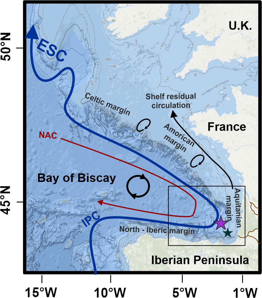
In the mid-latitudes of the northeast Atlantic, the study of the upper branch of the AMOC is poorly documented. This study provides a complete record of the glacial, deglacial and Holocene dynamics of the easternmost portion of the upper branch of the AMOC, namely the European Slope Current and its glacial equivalent know as the Glacial Eastern Boundary Current (GEBC). To do so, we use core SU81-44 (~1000 m water depth) from the of southern Bay of Biscay (BoB) upper slope, .The aim of this study is to reconstruct paleoenvironmental and hydrodynamic changes using a multiproxy approach (i.e. benthic foraminiferal assemblage, grain size proxies, oxygen and carbon stable isotopes, and foraminiferal εNd). During the glacial period and the onset of the deglaciation, our results show that the grain size proxies together with the relative densities of the high-energy indicator species Trifarina angulosa and the low oxygen tolerant Globobulimina spp. showed significant fluctuations. These were concomitant with the main climate changes recognized over this period and with the glacial slope paleoflow reconstruction from the northern BoB. This highlights a strong climatic/oceanographic forcing on the sedimentary characteristics of the region and a prominent forcing by changes in near-bottom flow speed. Our data also provide a new constraint on the strength of the slope current in the region during the late deglaciation and Holocene periods. We observe a reinvigoration of the upper branch of the AMOC during the Bølling-Allerød warming, preceding the abrupt resumption of the deeper branch of the AMOC in the western North Atlantic. This seems to confirm the crucial role of the European Slope Current in deep water formation, as it is the case today. Finally, our data show a progressive weakening of the ESC during the Holocene and we hypothesize a link with the long-term dynamics of the subpolar gyre.
-

Good Environmental Status assessment (GES) for descriptor 8 (contaminants, D8) of the Marine Strategy Framework Directive (MSFD) is reached when concentrations of contaminants are at levels not giving rise to pollution effects. It is described by 4 criteria among which the first one focus on the concentration of the contaminants in the environment (criteria 1 of the D8, D8C1). The environmental status for D8 in France includes assessment of contaminant concentrations in sediment, bivalves, fish, birds, mammals to cover the French marine area the continental shelf from the coast line). The 8 tables below present the assessment of the chemical contamination in sediment and bivalves on the coastal area of the 4 French marine subregions for D8 as part of the 2024 GES assessment. These tables report the status and temporal trends of each station x matrice x substance triplet in each of the 4 French marine subregions. Explanation on how to read the cells is given in the “read file”. The environmental assessment for D8 in France can be found in Mauffret al., 2023 (DOI:10.13155/97214). It includes 17 national indicator assessments, 4 OSPAR indicators and integrated assessment in selected assessment units at the level of the criteria 1 and 2.
-

Sardine physiological measurments from september to november 2020
-
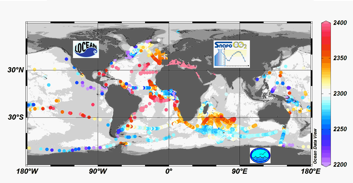
Since 2004, the Service facility SNAPO-CO2 (Service National d’Analyse des Paramètres Océaniques du CO2) housed by the LOCEAN laboratory (Paris, France) has been in charge for the analysis of Total Alkalinity (AT) and Total dissolved inorganic carbon (CT) of seawater samples on a series of cruises or ships of opportunity conducted in different regions in the frame of French projects. More than 44000 observations are synthetized in this work. Sampling was performed either from CTD-Rosette casts (Niskin bottles) or collected from the ship’s seawater supply (intake at about 5m depth). After completion of each cruise, discrete samples were returned back at LOCEAN laboratory and stored in a dark room at 4 °C before analysis generally within 2-3 months after sampling (sometimes within a week). AT and CT were analyzed simultaneously by potentiometric titration using a closed cell (Edmond, 1970). Certified Reference Materials (CRMs) provided by Pr. A. Dickson (Scripps Institution of Oceanography, San Diego, USA) were used to calibrate the measurements. The same instrumentation was used for underway measurements during OISO cruises (https://doi.org/10.18142/228) and OISO AT-CT data for 1998-2018 in the South Indian Ocean added in this synthesis. The synthesis is organized in two files (one for Global ocean and the Coastal Zones, one for the Mediterranean Sea) with the same format: Cruise name, Ship name, day, month, year, hour, minute, second, latitude, longitude, depth, AT (µmol/kg), Flag-AT, CT (µmol/kg), Flag-CT, Temperature (°C), Flag-Temp, Salinity (PSU), Flag-Salinity, nsample/cruise, nsample on file, sampling method.