Keyword

Seismic

8 record(s)
 
Type of resources
Available actions
Topics
Keywords
Contact for the resource
Provided by
Years
Formats
From 1 - 8 / 8
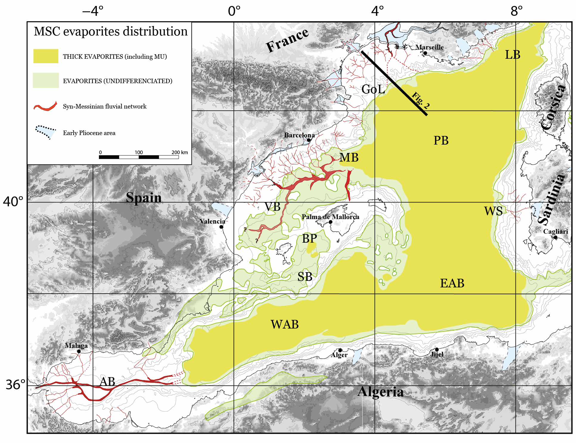
  • The Mediterranean Sea is a natural laboratory to address questions about the formation and evolution of continental margins and the relationship between surface and deep processes. Different regional to local events have influenced the Neogene stratigraphic evolution of the Valencia and Menorca basins. The evaporites deposited during the Messinian Salinity Crisis (MSC) strongly impact its sedimentary and geomorphological evolution. Here we present a compilation of the main regional seismic stratigraphic markers from the continental platform to the deep sea. We provide in xyz format (z in second twt) the original picking files, (not interpolated) and interpolated grid of: i) the top of the Mesozoic formation, the base of the Neogene formations including the early Miocene volcanic features, ii) the top Burdigalian, Langhian, and Serravallian seismic horizons, iii) the seismic horizons related to the Messinian Salinity Crisis, iv) the Pliocene and Pleistocene seismic horizons v) the depth of the Seafloor. The available reflection seismic dataset results from the compilation and processing of vintage seismic profiles of previous works and from the Instituto Geologico y Minero de Espana (IGME). This compilation is currently the first available in literature and provides a useful contribution to the scientific community working on sedimentary, tectonics and geodynamics within the Western Mediterranean basins.

  • The Western Mediterranean Sea is a natural laboratory to address questions about the formation and evolution of continental margins and the relationship between surface and deep processes. The evaporites deposited during the late Miocene’s Messinian Salinity Crisis (MSC) strongly impact its sedimentological and geomorphological evolution. Hereafter, we present a compilation of some of the main regional seismic stratigraphic markers throughout the Western Mediterranean Sea. We provide in xyz format (z in second twt) the original, not interpolated, points interpretation of the following horizons: i) Acoustic basement, ii) Base and Top of the MSC salt, also known as Mobile Unit (MU), iii) base Pliocene and iv) Seafloor. The available reflection seismic dataset, coming from a collaboration between French, Spanish, Algerian and Italian research institutes, covers most of the Western Mediterranean sub-basins with the exception of the Ligurian Basin. This compilation is currently the most comprehensive and updated available in literature and provides a useful contribution to the scientific community working in sedimentary, tectonics and geodynamics studies in the Western Mediterranean Sea.

  • The Mediterranean Sea is a natural laboratory for addressing questions on the formation and evolution of continental margins and the relationship between surface and deep processes. The evaporites deposited during the Messinian Salinity Crisis strongly impact its sedimentary and geomorphology evolution. We present here a compilation of the main regional seismic stratigraphic markers throughout the Central and South Adriatic Sea (CAB and SAB). The following original (uninterpolated) interpretations are provided in xyz format (z in second twt): i) Top of the Mesozoic formation, ii) Base and Top of the Gessoso Solfifera along the CAB, iii) Base and Top of the MSC detrital formation along the SAB, iv) Top of the Upper Unit, v) Base and Top of the middle Pliocene unit, vi) Seafloor. The available reflection seismic dataset the data set is compiled of processed vintage seismic profiles from the Videpi database.

  • This dataset contains raw data, drift corrected data and SeisComP 3 Data Structure (SDS) from Ocean Bottom Seismometers (OBS) deployed at EMSO-Azores from July 2014 to April 2015. The raw data are initialy in Lcheapo format. They are fixed at first to remove bugs and they are transformed to miniSEED format. The drift corrected data are obtained from fixed raw data. The drift corrected data are obtained from fixed raw data. A value is put in the Time Correction eld (eld 16) of each data header. By default, the correction is applied to the Record Start Time (eld 8) and the Time Correction Applied ag (eld 12, bit 1) is activated. Alternatively, only the Time Correction Applied eld is changed. Seiscomp3 Data Structure (SDS) is the final product. It's the correct structure to be use in the Seiscomp 3 software.

  • This dataset contains raw data, drift corrected data and SeisComP 3 Data Structure (SDS) from Ocean Bottom Seismometers (OBS) deployed at EMSO-Azores from July 2012 to August 2013. The raw data are initialy in Lcheapo format. They are fixed at first to remove bugs and they are transformed to miniSEED format. The drift corrected data are obtained from fixed raw data. The drift corrected data are obtained from fixed raw data. A value is put in the Time Correction eld (eld 16) of each data header. By default, the correction is applied to the Record Start Time (eld 8) and the Time Correction Applied ag (eld 12, bit 1) is activated. Alternatively, only the Time Correction Applied eld is changed. Seiscomp3 Data Structure (SDS) is the final product. It's the correct structure to be use in the Seiscomp 3 software.

  • This dataset contains raw data, drift corrected data and SeisComP 3 Data Structure (SDS) from Ocean Bottom Seismometers (OBS) deployed at EMSO-Azores from July 2011 to July 2012. The raw data are initialy in Lcheapo format. They are fixed at first to remove bugs and they are transformed to miniSEED format. The drift corrected data are obtained from fixed raw data. The drift corrected data are obtained from fixed raw data. A value is put in the Time Correction eld (eld 16) of each data header. By default, the correction is applied to the Record Start Time (eld 8) and the Time Correction Applied ag (eld 12, bit 1) is activated. Alternatively, only the Time Correction Applied eld is changed. Seiscomp3 Data Structure (SDS) is the final product. It's the correct structure to be use in the Seiscomp 3 software.

  • This dataset contains raw data, drift corrected data and SeisComP 3 Data Structure (SDS) from Ocean Bottom Seismometers (OBS) deployed at EMSO-Azores from April 2015 to August 2016. The raw data are initialy in Lcheapo format. They are fixed at first to remove bugs and they are transformed to miniSEED format. The drift corrected data are obtained from fixed raw data. The drift corrected data are obtained from fixed raw data. A value is put in the Time Correction eld (eld 16) of each data header. By default, the correction is applied to the Record Start Time (eld 8) and the Time Correction Applied ag (eld 12, bit 1) is activated. Alternatively, only the Time Correction Applied eld is changed. Seiscomp3 Data Structure (SDS) is the final product. It's the correct structure to be use in the Seiscomp 3 software.

  • Abstract: The 2015 VESPA voyage (Volcanic Evolution of South Pacific Arcs) was a seismic and rock dredging expedition to the Loyalty and Three Kings Ridges and South Fiji Basin. In our paper we present 33 40Ar/39Ar, 22 micropaleontological, and two U/Pb ages for igneous and sedimentary rocks from 33 dredge sites in this little-studied part of the southwest Pacific Ocean. Igneous rocks include basalts, dolerites, basaltic andesites, trachyandesites, and a granite. Successful Ar/Ar dating of altered and/or low-K basalts was achieved through careful sample selection and processing, detailed petrographic and element mapping of groundmass, and incremental heating experiments on both phenocryst and groundmass separates to interpret the complex spectra produced by samples having multiple K reservoirs. The 40Ar/39Ar ages of most of the sampled lavas, irrespective of composition, are latest Oligocene to earliest Miocene (25-22 Ma); two are Eocene (39-36 Ma). The granite has a U/Pb zircon age of 23.6±0.3 Ma. 40Ar/39Ar lava ages are corroborated by microfossil ages from associated sedimentary rocks. The VESPA lavas are part of a >3000 km long disrupted belt of Eocene to Miocene subduction-related volcanic rocks. The belt includes arc rocks in Northland New Zealand, Northland Plateau, Three Kings Ridge, and Loyalty Ridge and, speculatively, D’Entrecasteaux Ridge. This belt is the product of superimposed Eocene and Oligocene-Miocene remnant volcanic arcs that were stranded along and near the edge of Zealandia while still-active arc belts migrated east with the Pacific trench. Plain word summary: Samples of lava from the seabed between New Zealand and New Caledonia have been dated using atomic clocks and fossils. Most lavas erupted in a big pulse of volcanic activity between 25 and 22 million years ago. They are part of a belt of now-extinct undersea volcanoes that stretches for more than 3000 km between New Zealand and the Solomon Islands. These volcanoes were formed by subduction of the Pacific Plate under the Australian Plate.