 Catalogue PIGMA
Geology
Type of resources
Available actions
Topics
Keywords
Contact for the resource
Provided by
Years
Formats
Representation types
Update frequencies
status
Scale
Resolution
-

Distribution of three geomorphologic features (fracture zones, canyons, and seamounts) on the North Atlantic (18°N to 76°N and 36°E to 98°W). Source vector data originated from the GEBCO Gazetteer of Undersea Features Names for fractures, Harris & Whiteway (2011) for canyons, and Yesson et al. (2011) for seamounts. The presence (value=1) of fracture zones or seamounts and the total length of canyons (in km, independently for shelf-incising or blind canyons) was extracted in 25km * 25km gridsquares. This dataset was built to feed a basin-wide spatial conservation planning exercise, targeting the deep sea of the North Atlantic. The goal of this approach was to identify conservation priority areas for Vulnerable Marine Ecosystems (VMEs) and deep fish species, based on the distribution of species and habitats, human activities and current spatial management.
-
Specification of the desirable and recommended product attributes for sediment mass budget at the coast for the last 10, 50 and 100 years for the Mediterranean basin and for each NUTS3 region along the coast.
-

Description of attributes for sediment mass budget at the coast for the last 10, 50 and 100 years for the Mediterranean basin and for each NUTS3 region along the coast.
-
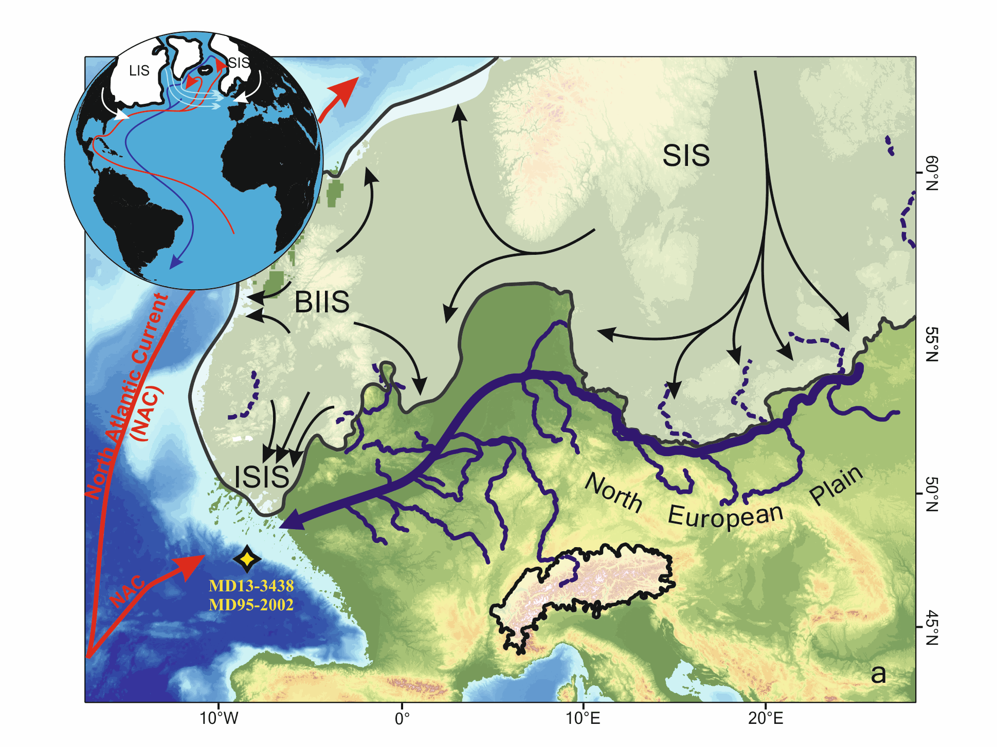
Marine microfossils (dinoflagellate cysts and planktonic foraminifera) and geochemical (XRF-Ti/Ca)-based climatic records from a core located off the Fleuve Manche (FM) paleo-mouth (MD13-3438) have revealed that sustained warm summer sea surface temperatures (SSTs) during sub-millennial climate changes within HS1 (~18–14.7 ka) may have played a key role in the FM regime related to the European Ice Sheet (EIS) melting rate. In this study, we have analyzed the MD13-3438 pollen content over the HS1 at a mean resolution of ~50 years to test whether vegetation-based air temperatures were coupled to SSTs face to this rapid climate variability. First, our results highlight two major phases of pollen sources at site MD13-3438, preventing the pollen record to be interpreted as a continuous record of the evolution of vegetation and climate occupying a single watershed across HS1. The first phase, i.e. the HS1-a interval (~18–16.8 ka), is marked by strong occurrences of boreal pollen taxa (especially Picea-Abies). Considering their spatial distribution and the coalescence of the British and Scandinavian ice sheets into the North Sea during the Last Glacial Maximum, these taxa probably originated from the North European Plain, i.e., eastern FM tributaries (east of the Rhine River), where cool-humid conditions generally prevailed. Then, the second phase, i.e. the HS1-b interval (~16.8–14.7 ka BP), is characterized by a deceleration of the EIS retreat and the drop of boreal pollen values at site MD13-3438 further signing a less influence of the upstream FM drainage system and thus a better characterization of pollen sources related with western FM tributaries. Superimposed to these two HS1 main phases, pollen fluctuations are concomitant with sub-millennial variability in the EIS deglaciation intensity. During the early HS1 (HS1-a), we discussed two short-term increases in the ratio between deciduous trees (Quercus-Corylus-Alnus) and herbaceous plants (Plantago-Amaranthaceae-Artemisia). These events were coeval with phases of increasing FM meltwater runoff and SST seasonality (i.e., dinocyst-based summer SST amplification). We associated these events with lower contribution of the upstream FM catchment as well as, possibly, atmospheric warming and regional sea-level positive oscillations. The HS1-b is composed of three main phases that appear more influenced by the downstream FM drainage system. HS1-b1 (16.8–16.3 ka BP) corresponds to the driest and coldest conditions west of the Rhine River. HS1-b2 (16.3–15.6 ka BP) is coeval with large arrivals of iceberg from the Hudson strait in the Bay of Biscay and thus likely to a major sea-level positive oscillation associated with a phase of FM valley reworking. HS1-b3 (15.6–14.7 ka BP) corresponds to persistent arid conditions that preceded the subsequent more humid conditions recorded from 14.7 ka BP at the start of the Bölling-Alleröd.
-
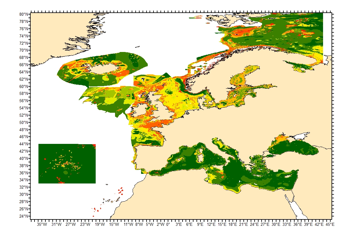
Sediment average grain size in the European North-East Atlantic and Mediterranean waters was generated from Euseamap 2023 sediment categories. This rough granulometry estimate may be used for habitat models at meso- and large scale.
-
Cadre géologique des Pyrénées-Atlantiques. La numérisation a été réalisée à partir d’une carte produite par le BRGM.
-

-
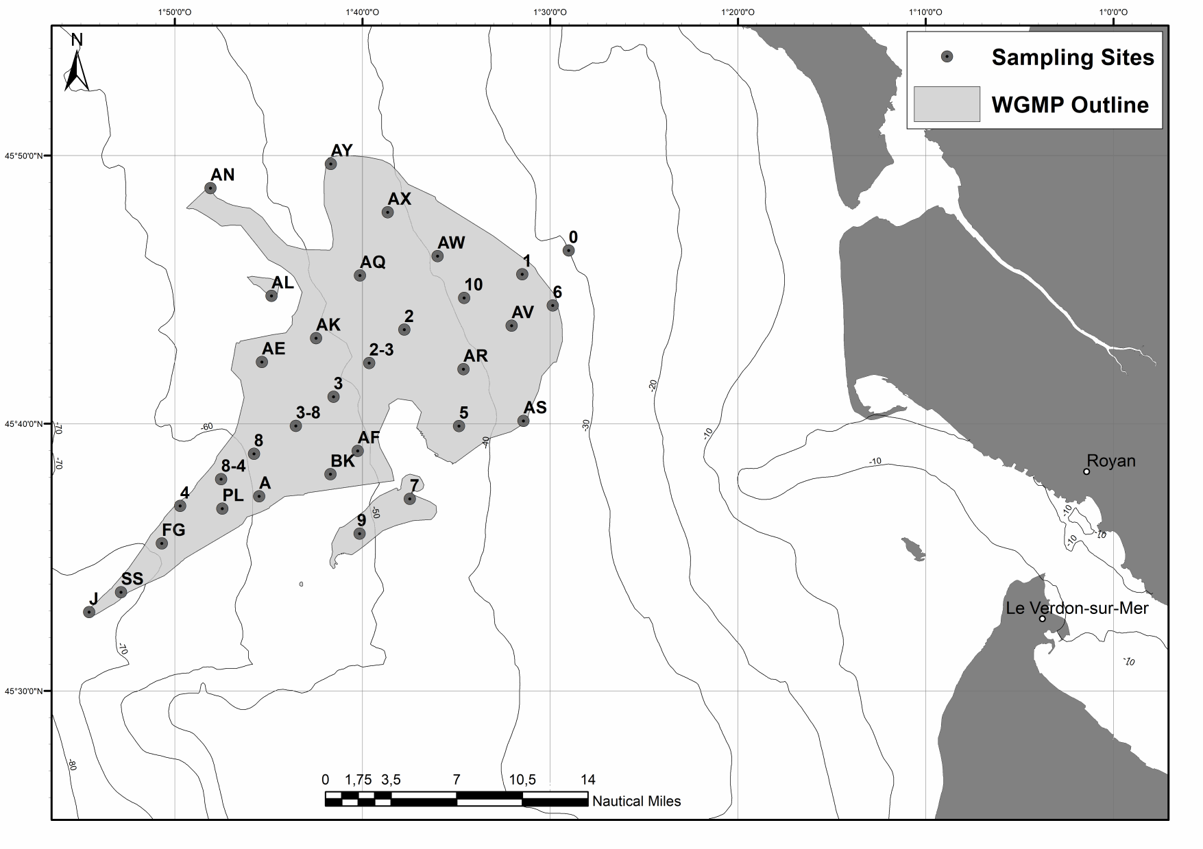
The spatial distributions of (1) surface sediment characteristics (D0.5, Sediment Surface Area (SSA), Particulate Organic Carbon (POC), Chlorophyll-a (Chl-a), Phaeophytin-a (Phaeo-a), Total and Enzymatically Hydrolyzable Amino Acids (THAA, EHAA), δ13C) and (2) sediment profile image (apparent Redox Potential Discontinuity (aRPD), numbers and depths of biological traces) characteristics were quantified based on the sampling of 32 stations located within the West Gironde Mud Patch (Bay of Biscay, NE Atlantic) in view of (1) assessing the spatial structuration of a temperate river-dominated ocean margin located in a high-energy area, (2) disentangling the impacts of hydrodynamics and bottom trawling on this structuration, and (3) comparing the West Gironde Mud Patch with the Rhône River Prodelta (located in a low-energy area). Results support the subdivision of the West Gironde Mud Patch in a proximal and a distal part and show (1) the existence of depth gradients in surface sedimentary organics characteristics and bioturbation within the distal part; (2) no evidence for a significant effect of bottom trawling, as opposed to Bottom Shear Stress, on the West Gironde Mud Patch spatial structuration; and (3) major discrepancies between spatial structuration in the West Gironde Mud Patch and the Rhône River Prodelta, which were attributed to differences in tidal regimes, sedimentation processes, and local hydrodynamics, which is in agreement with current river-dominated ocean margin typologies.
-
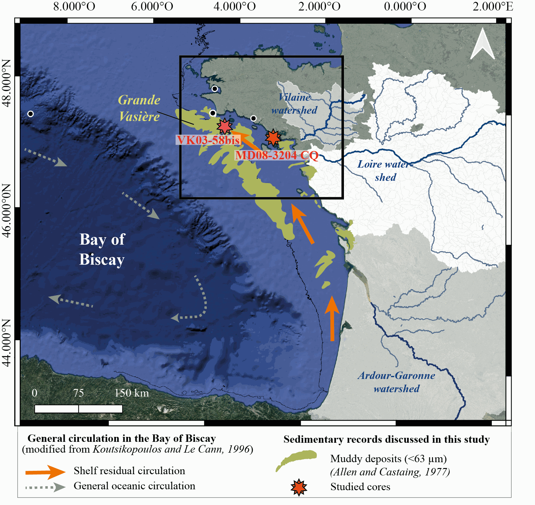
New results acquired in south-Brittany (MD08-3204 CQ core: Bay of Quiberon and VK03-58bis core: south Glénan islands) allow depicting Holocene paleoenvironmental changes from 8.5 ka BP to present through a multi-proxy dataset including sedimentological and palynological data. First, grain-size analyses and AMS-14C dates highlight a common sedimentary history for both study cores. The relative sea level (RSL) slowdown was accompanied by a significant drop of the sedimentation rates between ca. 8.3 and 5.7 ka BP, after being relatively higher at the onset of the Holocene. This interval led to the establishment of a shell-condensed level, identified in core VK03-58bis by the “Turritella layer” and interpreted as a marker for the maximum flooding surface. Palynological data (pollen grains and dinoflagellate cyst assemblages) acquired in core MD08-3204 CQ argue for an amplification of the fluvial influence since 5.7 ka BP; the establishment of the highstand system tract (i.e., mixed marine and fluviatile influences on the platform) then accompanying the slowdown of the RSL rise-rates. On the shelf, the amplification of Anthropogenic Pollen Indicators (API) is then better detected since 4.2 ka BP, not only due to human impact increase but also due to a stronger fluvial influence on the shelf during the Late Holocene. Palynological data, recorded on the 8.5–8.3 ka BP interval along an inshore-offshore gradient, also demonstrate the complexity of the palynological signal such as i) the fluvial influence that promotes some pollinic taxa (i.e., Corylus, Alnus) from proximal areas and ii) the macro-regionalization of palynomorph sources in distal cores. In addition, the comparison of palynological tracers, including API, over the last 7 kyrs, with south-Brittany coastal and mid-shelf sites subjected to northern vs. southern Loire catchment areas, allowed discussing a major hydro-climatic effect on the reconstructed palynological signals. Strengthened subpolar gyre dynamics (SPG), combined with recurrent positive North Atlantic Oscillation (NAO) configurations, appear responsible for increased winter precipitations and fluvial discharges over northern Europe, such as in Brittany. Conversely, weakened SPG intervals, associated with negative NAO-like modes, are characterized by intensified winter fluvial discharges over southern Europe. Interestingly, we record, at an infra-orbital timescale, major peaks of API during periods of strengthened (/weakened) SPG dynamics in sites subjects to Brittany watersheds (/Loire watersheds) inputs.
-