 Catalogue PIGMA
Bathymetry
Type of resources
Available actions
Topics
Keywords
Contact for the resource
Provided by
Years
Formats
Representation types
Update frequencies
status
Service types
Resolution
-
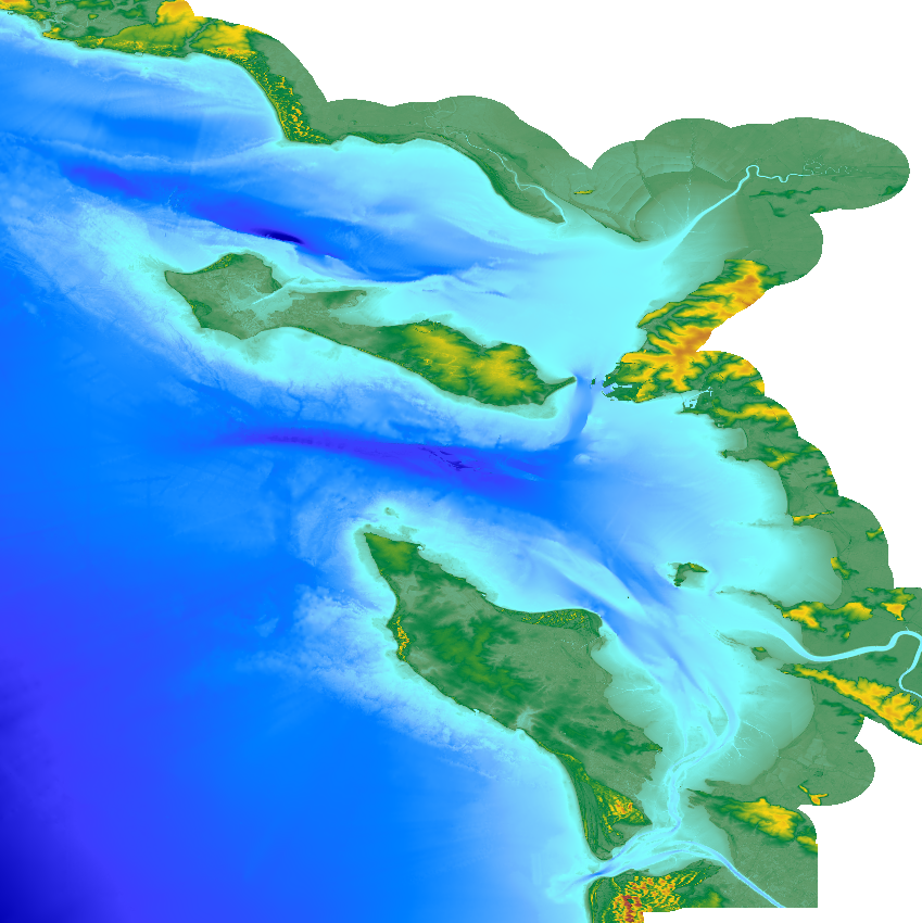
The update of the coastal topo-bathymetric DEM of the Pertuis charentais at a resolution of 0.0002° (~ 20 m) was carried out in the third phase of the HOMONIM project. The DEM extends from the terrestrial domain to about 60 meters depth over all the pertuis (pertuis Breton, pertuis d’Antioche and pertuis of Maumusson). The DEM is intended to be implemented in hydrodynamic models in order to produce forecasts as accurate as possible of water heights and sea states at the coast to improve the relevance of the Wave-Submergence Vigilance. This product is available with either the Lowest Astronomic Tide (LAT) or the Mean Sea Level (MSL) as a vertical reference.
-
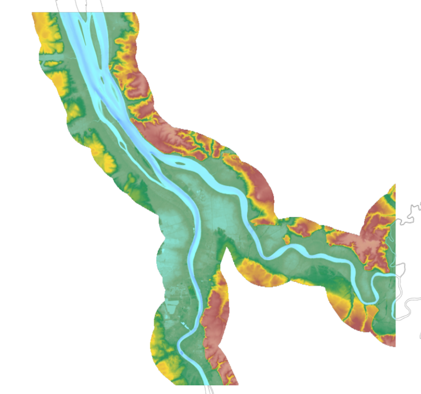
The update of the coastal topo-bathymetric DEM of the Gironde estuary - upstream with a resolution of 0.0002° (~ 20 m) was carried out in the third phase of the HOMONIM project. This DEM covers the upstream part of the Gironde estuary, from Pauillac to Bordeaux on the Garonne and to Libourne on the Dordogne. It is complementary to the DEM covering the downstream estuary (between Pauillac and the mouth of the Gironde). The DEM is intended to be implemented in hydrodynamic models in order to produce forecasts as accurate as possible of water heights and sea states at the coast to improve the relevance of the Wave-Submergence Vigilance. This product is available with either the Lowest Astronomic Tide (LAT) or the Mean Sea Level (MSL) as a vertical reference.
-

Digital Surface Models (DSMs) of the study area surveyed by drone between June 2024 and March 2025. Each pixel contains the elevation value corresponding to the terrain at the time of the mission. These DSMs were generated from around 1,300 images (depending of the survey) acquired using the DJI Mavic 3E RTK drone, with a resolution of 3.2 cm/pixel. The surveyed area covers around 2.1 km². The campaign was conducted on the highest tides of each month. The drone acquisitions were carried out by Nicolas Lachaussée from the LIENSs UMR Drone Platform. Photogrammetric processing was performed by Natacha Volto (LIENSs) using Agisoft Metashape software. The vertical coordinate system is NGF IGN69. The vertical accuracy (RMSD ~ 3 cm), calculated using around 100 control points, randomly distributed across the study area. It is derived from the vertical difference for each control point between the value measured with the DGPS SP80 and the value extracted from the photogrammetry-generated DSM. These drone surveys were carried out as part of the thesis of Loës Le Goff Le Gourrierec supervised by Xavier Bertin.
-

The coastal topobathymetric DEM of Ré Island's surroundings, with a resolution of 0.00005° (~5 meters), was created by Shom as part of the HOMONIM-3 project. It covers the coast of the municipalities of Ars-en-Ré and Saint-Clément-des-Baleines, extending offshore to a depth of about 20 meters, to the west of the Phare des Baleines lighthouse. This DEM is designed for use in hydrodynamic models to enhance the modeling of coastal processes, particularly forecasting submersion risk. The product complements the coastal topobathymetric DEM of the Pertuis-Charentais, with a resolution of 0.0002° (~20 meters), and the bathymetric DEM of the Atlantic coast, with a resolution of 0.001° (~100 meters). It is available in the vertical reference of the Lowest Astronomical Tide (LAT) or the Mean Sea Level (MSL).
-

The update of the coastal topo-bathymetric DEM of the Gironde estuary - downstream with a resolution of 0.0002° (~ 20 m) was carried out in the third phase of the HOMONIM project. This DEM covers the downstream part of the Gironde estuary, from Pauillac to its mouth. It is complementary to the DEM covering the upstream estuary. The DEM is intended to be implemented in hydrodynamic models in order to produce forecasts as accurate as possible of water heights and sea states at the coast to improve the relevance of the Wave-Submergence Vigilance. This product is available with either the Lowest Astronomic Tide (LAT) or the Mean Sea Level (MSL) as a vertical reference.
-
The present dataset is based on a nine site study of fine seabed topography in intertidal zones. Four coral sites (Maupiti A, B and C and Niau islands) and five rocky sites (Ars en Ré, Socoa, Parlementia A and B and Banneg island) have been explored. The data has been gathered using on-foot GNSS RTK for all sites (Trimble R8/R8S and Leica sytems) except Banneg island, where aerial Lidar data from Litto3D program has been used. The horizontal resolution varies between 3.8 and 12cm allowing to describe a wide range of spatial scales (generally over 3 spectral decades). The data has been processed to explore the statistical and spectral metrics which can be used to characterize the architectural complexity of seabeds.
-
WMS for EMODNet HRSM CDI services by SeaDataNet
-
WFS for EMODNet HRSM CDI services by SeaDataNet
-
The Western Mediterranean Sea is a natural laboratory to address questions about the formation and evolution of continental margins and the relationship between surface and deep processes. The evaporites deposited during the late Miocene’s Messinian Salinity Crisis (MSC) strongly impact its sedimentological and geomorphological evolution. Hereafter, we present a compilation of some of the main regional seismic stratigraphic markers throughout the Western Mediterranean Sea. We provide in xyz format (z in second twt) the original, not interpolated, points interpretation of the following horizons: i) Acoustic basement, ii) Base and Top of the MSC salt, also known as Mobile Unit (MU), iii) base Pliocene and iv) Seafloor. The available reflection seismic dataset, coming from a collaboration between French, Spanish, Algerian and Italian research institutes, covers most of the Western Mediterranean sub-basins with the exception of the Ligurian Basin. This compilation is currently the most comprehensive and updated available in literature and provides a useful contribution to the scientific community working in sedimentary, tectonics and geodynamics studies in the Western Mediterranean Sea.
-

The EuroMapApp task of the AtlantOS project aims to integrate Europe’s existing and future bathymetric data sets from the Atlantic Ocean into a seamless whole and put these results into a widely accessible format allowing immediate visualization of the seafloor for the specialist and non-specialist user alike. The partner institutions are GEOMAR, Ifremer, NIOZ, and NERC-BODC.