 Catalogue PIGMA
ocean heat content
Type of resources
Available actions
Topics
Keywords
Contact for the resource
Provided by
Years
Formats
Representation types
Update frequencies
status
Scale
-
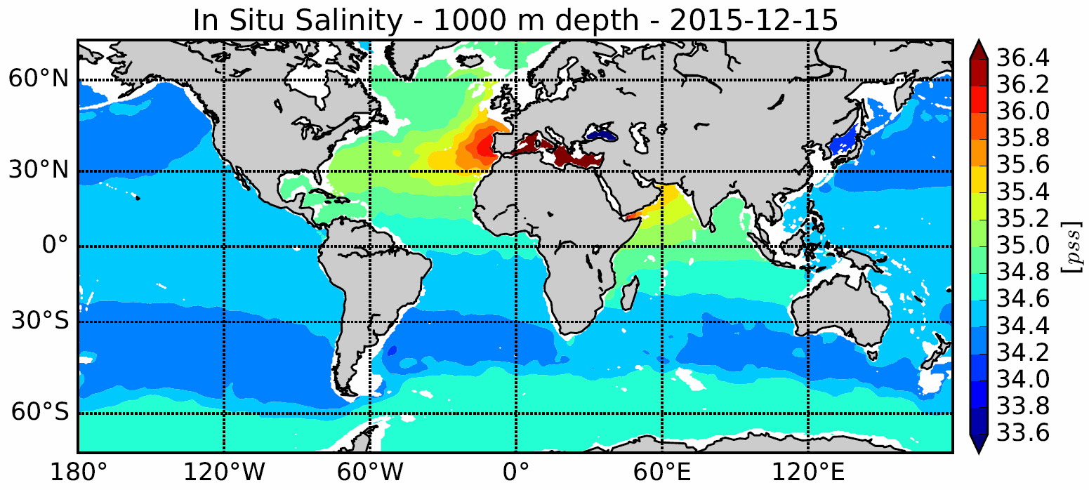
The In Situ Analysis System (ISAS) was developed to produce gridded fields of temperature and salinity that preserve as much as possible the time and space sampling capabilities of the Argo network of profiling floats. ISAS is based on Optimal Interpolation method. Since the first global re-analysis performed in 2009, the system has been extended to accommodate all types of vertical profile as well as time series. ISAS gridded fields are entirely based on in-situ measurements. The system aims at monitoring the time evolution of ocean properties for climatic studies and allowing easy computation of climate indices. Delayed Mode (D) profiles are used a much as possible and extra visual check is carried out. The ISAS procedure and products are described in Gaillard et al. (2016). The present DOI provides both analyzed fields and standardized profiles data used in interpolation. ISAS provide now also gridded fields of dissolved oxgyen from BGC Argo floats. HISTORY ISAS20_ARGO_*_DOXY: The ISAS20_ARGO_*_DOXY release is BGC Argo DOXY variable interpolated on 187 standard depth levels between 0-5500 m depth and 0.5°x0.5° global horizontal grid. ISAS20 use the version 8 of ISAS and updated statistics to produce the monthly analysis (Monthly Climatology and annual STD computed from WOA18A5B7). ISAS20 gridded fields analyze yearly mean of the Argo dissolved oxygen data over 3 periods : 2009-2018, 2009-2013, and 2014-2018. ISAS20_ARGO: The ISAS20_ARGO release is interpolated on 187 standard depth levels between 0-5500 m depth and 0.5°x0.5° global horizontal grid. ISAS20 use the version 8 of ISAS and updated statistics to produce the monthly analysis (Monthly Climatology and annual STD computed from WOA18A5B7). ISAS20 gridded fields analyze the Argo and Deep-Argo temperature and salinity data alone between 2002-2020. ISAS17: The ISAS17 release is interpolated on 187 standard depth levels between 0-5500 m depth and 0.5°x0.5° global horizontal grid. ISAS17 use the version 8 of ISAS and updated statistics to produce the monthly analysis (Monthly Climatology and annual STD computed from WOA18A5D). ISAS17 gridded fields analyze the Argo and Deep-Argo temperature and salinity profiles, and other in situ measurements between 2002-2017 to complete observations, including the higher latitudes (typically poleward of 60°S-N) where Argo sampling is sparse or not existent. ISAS-SSS : The ISAS-SSS release is interpolated on 4 standard depth levels (1-3-5-10m depth) and 0.5°x0.5° global horizontal grid between 2002-2015. ISAS-SSS use the version 7 of ISAS and updated the statistics to produce the monthly analyses (Monthly Climatology computed from ISAS13 and annual STD computed from Argo dataset). ISAS-SSS gridded fields analyze the Argo and other in situ salinity data, including TSG from research and ship of opportunity from French SNO-SSS. ISAS15 : The ISAS15 release is interpolated on 152 standard depth levels between 0-2000 m depth and 0.5°x0.5° global horizontal grid between 2002-2015. ISAS15 use the version 7 of ISAS and updated statistics to produce the monthly analysis (Monthly Climatology computed from ISAS13 and annual STD computed from Argo dataset). ISAS15 gridded fields analyze the Argo temperature and salinity data alone in its ISAS15_ARGO configuration; or Argo plus other in situ measurements in its ISAS15 configuration. ISAS13 : The ISAS13 release is interpolated on 152 standard depth levels between 0-2000 m depth and 0.5°x0.5° global horizontal grid between 2002-2012. ISAS13 use the version 6 of ISAS and updated statistics to produce the monthly analysis (Monthly Climatology computed from ISAS11 and annual STD computed from Argo dataset). ISAS13 gridded fields analyze the Argo temperature and salinity data and other in situ measurements between 2002-2012. For detailed information and description of the ISAS products please visit the dedicated Argo France web page: https://www.argo-france.fr/Argo-Data-Products/Argo-France-products
-
Un jeu de données mondial sur les déplacements en profondeur, nommé ANDRO, d'après une danse traditionnelle de la Bretagne signifiant un tourbillon, comprenant plus de 600 000 déplacements en profondeur, a été produit à partir des données Argo float. Une caractéristique importante de l’ANDRO est que les pressions mesurées lors de la dérive des flotteurs en profondeur, et convenablement moyennées, sont conservées dans ANDRO . Pour atteindre cet objectif, il était nécessaire de retraiter la plupart des données brutes Argo, en raison des nombreuses versions de décodage différentes (environ 100) pas toujours appliquées par les CNA aux données de déplacement, car ils étaient principalement intéressés par les paramètres p, t, S. profils. Le résultat de nos travaux a été la production de fichiers complets, nommés DEP, contenant toutes les données flottantes éventuellement récupérables. Le contenu et le format actuels d'ANDRO sont décrits dans le guide de l'utilisateur http://archimer.ifremer.fr/doc/00360/47126/, qui doit être lu avant d'utiliser ANDRO (le format ANDRO est également décrit dans Ollitrault M. et al (2013) http://archimer.ifremer.fr/doc/00138/24901/ ).
-

Le Système d'analyse in situ (ISAS) a été développé pour produire des champs de température et de salinité qui préservent autant que possible les capacités d'échantillonnage du temps et de l'espace du réseau des flotteurs Argo. Depuis la première analyse globale réalisée en 2009, le système a été étendu pour tenir compte de tous les types de profils verticaux ainsi que les séries temporelles, ainsi que des nouveaux paramètres tel que l'oxygène dissous produits par BGC Argo. Les champs grillés ISAS sont entièrement basés sur des mesures in situ. Le système vise à surveiller l'évolution des propriétés de l'océan en fonction du temps pour les études climatologiques et permettre un calcul facile des indices climatiques. Un traitement en temps différé de l'ensemble de données 2002-2020 a été réalisé à l'aide de la version 8 d'ISAS et la mise à jour des statistiques a priori. Notez que ISAS-V8 est mis en œuvre comme outil d'analyse opérationnelle au centre de données Coriolis depuis juin 2020.