 Catalogue PIGMA
2026
Type of resources
Available actions
Topics
Keywords
Contact for the resource
Provided by
Years
Formats
Representation types
Update frequencies
status
Service types
Scale
Resolution
-
-
Long-term time series of coliform bacteria concentration (fecal coliform or Escherichia coli) in shellfish in four submarine areas (North Sea/Channel, Britany, Atlantic, Mediterranean).
-
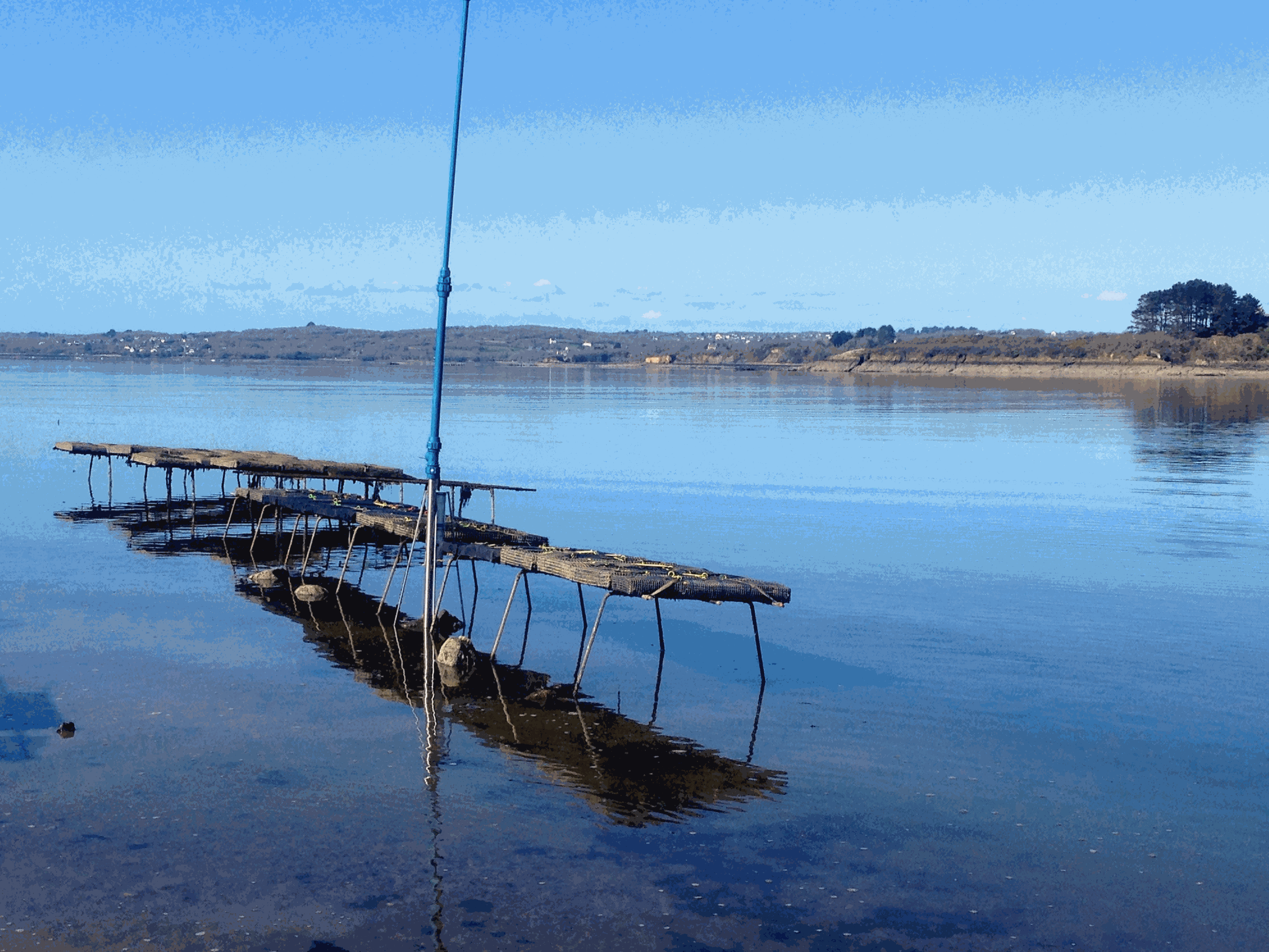
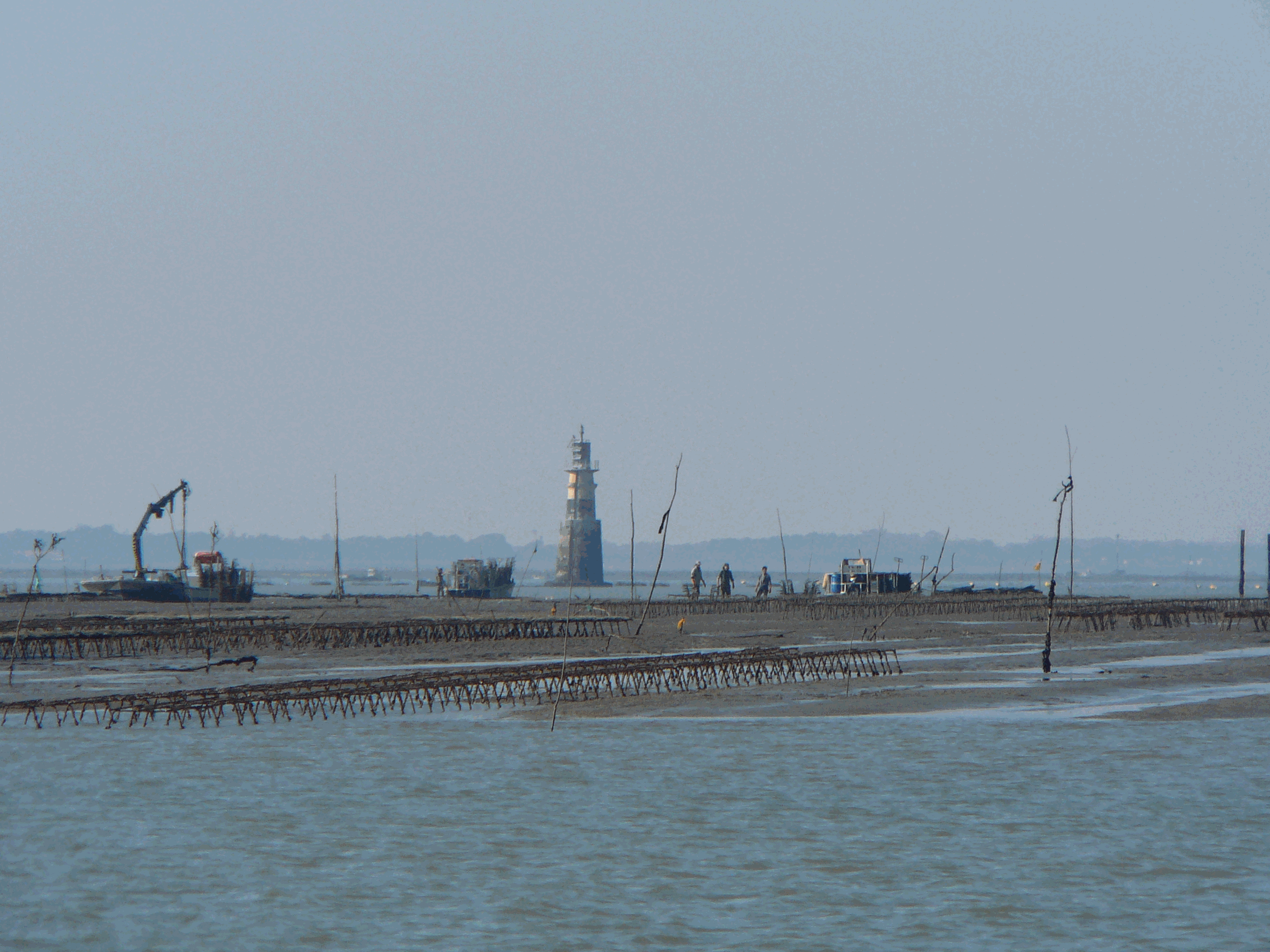
Based on the consolidation of the Ifremer networks RESCO (https://doi.org/10.17882/53007) and VELYGER (https://doi.org/10.17882/41888), the general objective of the ECOSCOPA project is to analyze the causes of spatio-temporal variability of the main life traits (Larval stage - Recruitment - Reproduction - Growth – Survival – Cytogenetic anomalies) of the Pacific oyster in France and follow their evolution over the long term in the context of climate change. The high frequency environmental data are monitored since 2010 at several stations next to oyster farm areas in eight bays of the French coast (from south to north): Thau Lagoon and bays of Arcachon, Marennes Oléron, Bourgneuf, Vilaine, Brest, Mont Saint-Michel and Veys (see map below). Sea temperature and practical salinity are recorded at 15-mins frequency. For several sites, fluorescence and turbidity data are also available. Data are acquired with automatic probes directly put in oyster bags or fixed on metallic structure at 50 cm over the sediment bottom, except for Thau Lagoon whose probes are deployed at 2m below sea surface. Since 2010, several types of probes were used: STP2, STPS, SMATCH or WiSens CTD from NKE (www.nke-instrumentation.fr) and recently ECO FLNTU (www.seabird.com). The probes are regularly qualified by calibrations in the Ifremer coastal laboratories. Precision estimated of the complete data collection process is: temperature (±0.1°C), salinity (±0.5psu), in vivo fluorescence (±10%), turbidity (±10%). The data are qualified into several levels: 0-No Quality Check performed, 1-Good data, 2-Probably good data, 3-Probably bad data, 4-Bad data, 5-Value changed, 7-Nominal value, 8-Interpolated value, 9-Missing value.
-

Plankton was imaged with the PlanktoScope in different oceanic regions using different nets and protocol of conservation. This dataset aims to serve as reference for taxonomic identification with the PlanktoScope across 256 plankton taxa from 20µm to 300µm. Reference dataset can also serve as learning set for prediction in Ecotaxa (https://ecotaxa.obs-vlfr.fr/prj/15535). The full images were processed and segmented with the PlanktoScope around each individual. A set of associated features were measured on the objects with skimage.measure. All objects were classified into 256 different classes using the web application EcoTaxa (http://ecotaxa.obs-vlfr.fr). The following dataset corresponds to the 169, 149 objects and their calculated features. The different files provide information about the features of the objects, their taxonomic identification as well as the raw images. taxa.csv.gz Table of the classification of each object in the dataset, with columns: - object_id: unique object identifier in EcoTaxa. - annotation_category: taxonomic name corresponding to the last level of hierarchy - annotation_hierarchy: taxonomic lineage to the category - set: class of the image corresponding to the taxon - img_file_name: local path of the image corresponding to the taxon, named according to the object id features_native.csv.gz Table of morphological features computed by PlanktoScope. All features are computed on the object only, not the background. All area/length measures are in pixels. - object_id: unique object identifier in Ecotaxa And 33 features: - width: width of the smallest rectangle enclosing the object (pixel) - height: height of the smallest rectangle enclosing the object (pixel) - bx: X coordinates of the top left point of the smallest rectangle enclosing the object (pixel) - by: Y coordinates of the top left point of the smallest rectangle enclosing the object (pixel) - circ.: circularity of the object ((4∗π ∗Area)/Perim^2) [0-1] - area_exc: Surface area of the object excluding holes (pixel2) - area: Surface area of the object (pixel2) - %area: Percentage of object’s surface area that is comprised of holes - major: Length of the primary axis of the best fitting ellipse for the object (pixel) - minor: Length of the secondary axis of the best fitting ellipse for the object (pixel) - y: Y position of the center of gravity of the object (pixel) - x: X position of the center of gravity of the object (pixel) - convex_area: The area of the smallest polygon within which all points in the object fit (pixel2) - perim.: The length of the outside boundary of the object (pixel) - elongation: elongation index (major/minor) - perimareaexc: index of the relative complexity of the perimeter (perim/area_exc) - perimmajor: Index of the relative complexity of the perimeter (perim/major) - circex: Circularity of object excluding white pixels ((4 ∗ π ∗ Area_exc)/perim 2) - angle: Angle between the primary axis and a line parallel to the x-axis of the image - bounding_box_area: Area of the smallest box containing the object (pixel2) - eccentricity: Eccentricity of the ellipse that has the same second-moments as the region. Ratio of the focal distance of the ellipse over the major axis length [0-1] - equivalent_diameter: The diameter of a circle with the same area as the object (pixel) - euler_number: Euler characteristic of the set of non-zero pixels. Computed as number of connected components subtracted by number of holes - extent: Ratio of pixels in the object to pixels in the total bounding box - local_centroid_col: Horizontal coordinate of the center of mass of the object (pixel) - local_centroid_row: Vertical coordinate of the center of mass of the object (pixel) - solidity: Ratio of pixels in the object to pixels of the convex hull image (area / convex_area) - meanhue: Mean base color of the object in hue scale (0-360) - meansaturation: Mean saturation of the object [0-100] - meanvalue: Mean brightness of the object [0-100] - stdhue: Standard deviation of base color - stdsaturation: Standard deviation of saturation - stdvalue: Standard deviation of brightness inventory.tsv Tree view of the taxonomy and number of images in each taxon, displayed as text. With columns : - annotation_hierarchy: taxonomic lineage - annotation_category: name of the taxon - n: number of objects in each taxon group map.png Map of the sampling locations, to give an idea of the diversity sampled in this dataset. imgs Directory containing images of each object, named according to the object id object_id and sorted in subdirectories according to their taxon.
-

Dataset summaryPlankton and detritus are essential components of the Earth’s oceans influencing biogeochemical cycles and carbon sequestration. Climate change impacts their composition and marine ecosystems as a whole. To improve our understanding of these changes, standardized observation methods and integrated global datasets are needed to enhance the accuracy of ecological and climate models. Here, we present a global dataset for plankton and detritus obtained by two versions of the Underwater Vision Profiler 5 (UVP5). This release contains the images classified in 33 homogenized categories, as well as the metadata associated with them, reaching 3,114 profiles and ca. 8 million objects acquired between 2008-2018 at global scale. The geographical distribution of the dataset is unbalanced, with the Equatorial region (30° S - 30° N) being the most represented, followed by the high latitudes in the northern hemisphere and lastly the high latitudes in the Southern Hemisphere. Detritus is the most abundant category in terms of concentration (90%) and biovolume (95%), although its classification in different morphotypes is still not well established. Copepoda was the most abundant taxa within the plankton, with Trichodesmium colonies being the second most abundant. The two versions of UVP5 (SD and HD) have different imagers, resulting in a different effective size range to analyse plankton and detritus from the images (HD objects >600 µm, SD objects >1 mm) and morphological properties (grey levels, etc.) presenting similar patterns, although the ranges may differ. A large number of images of plankton and detritus will be collected in the future by the UVP5, and the public availability of this dataset will help it being utilized as a training set for machine learning and being improved by the scientific community. This will reduce uncertainty by classifying previously unclassified objects and expand the classification categories, ultimately enhancing biodiversity quantification.Data tablesThe data set is organised according to:- samples : Underwater Vision Profiler 5 profiles, taken at a given point in space and time. - objects : individual UVP images, taken at a given depth along the each profile, on which various morphological features were measured and that where then classified taxonomically in EcoTaxa.samples and objects have unique identifiers. The sample_id is used to link the different tables of the data set together. All files are Tab separated values, UTF8 encoded, gzip compressed.samples.tsv.gz - sample_id unique sample identifier - sample_name original sample identifier - project EcoPart project title - lat, lon location [decimal degrees] - datetime date and time of start of profile [ISO 8601: YYYY-MM-DDTHH:MM:SSZ] - pixel_size size of one pixel [mm] - uvp_model version of the UVP: SD: standard definition, ZD: zoomed, HD: high definitionsamples_volume.tsv.gzAlong a profile, the UVP takes many images, each of a fixed volume. The profiles are cut into 5 m depth bins in which the number of images taken is recorded and hence the imaged volume is known. This is necessary to compute concentrations. - sample_id unique sample identifier - mid_depth_bin middle of the depth bin (2.5 = from 0 to 5 m depth) [m] - water_volume_imaged volume imaged = number of full images × unit volume [L]objects.tsv.gz - object_id unique object identifier - object_name original object identifier - sample_id unique sample identifier - depth depth at which the image was taken [m] - mid_depth_bin corresponding depth bin [m]; to match with samples_volumes - taxon original taxonomic name as in EcoTaxa; is not consistent across projects - lineage taxonomic lineage corresponding to that name - classif_author unique, anonymised identifier of the user who performed this classification - classif_datetime date and time at which the classification was - group broader taxonomic name, for which the identification is consistent over the whole dataset - group_lineage taxonomic lineage corresponding to this broader group - area_mm2 measurements on the object, in real worl units (i.e. comparable across the whole dataset) … - major_mm - area measurements on the objet, in [pixels] and therefore not directly comparable among the different UVP models and units - mean … - skeleton_area properties_per_bin.tsv.gzThe information above allows to compute concentrations, biovolumes, and average grey level within a given depth bin. The code to do so is in `summarise_objects_properties.R`. - sample_id unique sample identifier - depth_range range of depth over which the concentration/biovolume are computed: (start,end], in [m] where `(` means not including, `]` means including - group broad taxonomic group - concentration concentration [ind/L] - biovolume biovolume [mm3/L] - avg_grey average grey level of particles [no unit; 0 is black, 255 is white]ODV_biovolumes.txt, ODV_concentrations.txt, ODV_grey_levels.txtThis is the same information as above, formatted in a way that Ocean Data View https://odv.awi.de can read. In ODV, go to Import > ODV Spreadsheet and accept all default choices.ImagesThe images are provided in a separate, much larger, zip file. They are stored with the format `sample_id/object_id.jpg`, where `sample_id` and `object_id` are the integer identifiers used in the data tables above.
-

Within the ESA Coastal Blue Carbon project, the LIENSs laboratory contributed drone-derived products, SP80 ground survey points (with longitude, latitude, and plant data) and biomass measurements to test classification models for mapping salt marsh vegetation (e.g., Esnandes) and associated biomass/carbon stocks. Links to associated datasets are provided at the bottom of this sheet.
-
-

The European Union’s Copernicus-funded TRUSTED project (Towards Fiducial Reference Measurements of Sea-Surface Temperature by European Drifters) has deployed over 100 state of the art drifting buoys for improved validation of Sea Surface Temperature (SST) from the Sentinel-3 Sea and Land Surface Temperature Radiometers (SLSTR). These buoys are manufactured by NKE. The TRUSTED drifting buoys data and metadata are distributed in qualtity control NetCDF files, as a subset of DBCP drifting buoys GDAC (Global Data Assembly Centre). Coriolis DAC (Data Assembly Centre) routinely collects, decodes, quality controls, preserves and distributes data and metadata as NetCDF-CF files. The TRUSTED buoys have specific features managed by Coriolis DAC python data processing chain: a high resolution temperature sensor in addition to the classic drifting buoy temperature sensor. The high sampling and high resolution observations are distributed in specific variables TEMP_HR, TEMP_HR_SPOT, TEMP_HR_XX (XX is the percentile sample).
-
Serveur wms du projet DCSMM
-

This dataset provides global surface winds and pressure fields on a 0.25° resolution horizontal grid with hourly frequency, based on the global ERA5 reanalysis but with enhanced realistic TCs, built from a parametric wind formulation fitted to SAR high-resolution observations. TC wind structures in ERA5 are indeed known to be strongly biased. The methodology, developed in Herry et al. (2025) and applied here, is to replace ERA5 underestimated winds in TCs by the parametric wind formulation of Wood et al. (2013) with optimized parameters (fitted to SAR data), while keeping ERA5 wind field elsewhere. The wind profile and the transition area between the parametric and ERA5 winds are adjusted for each TC, according to its intensity and size. This blended product manages to represent a variety of realistic TC structures, and ensure an asymmetry associated to the synoptic flow for each case.