Keyword

/Metropolitan France

65 record(s)
 
Type of resources
Available actions
Topics
Keywords
Contact for the resource
Provided by
Years
Formats
Representation types
Update frequencies
status
Scale
From 1 - 10 / 65
  • Wind analyses, estimated over the North Atlantic Ocean with a focus on some specific regions, are one the main ARCWIND (http://www.arcwind.eu/) project deliverables. They are estimated from various remotely sensed wind observations in combination with numerical model (WRF), with regular space (0.25deg in latitude and longitude), and time (00h:00, 06h:00, 12h:00, 18h:00 UTC), and based the method described in (Bentamy A., A. Mouche, A. Grouazel, A. Moujane, M. A. Ahmed. (2019): Using sentinel-1A SAR wind retrievals for enhancing scatterometer and radiometer regional wind analyses . International Journal Of Remote Sensing , 40(3), 1120-1147 . https://doi.org/10.1080/01431161.2018.1524174).

  • Landslides and gravitational features mapped within French metropolitan EEZ at 1 : 250 000 in the framework of work-package 6 (Geological Events and Probabilities) of the european project EMODNet Geology. These datasets were delivered during the phase 2 of the project.

  • Sediment substrate maps at different scales, of the French metropolitan EEZ produced in the work-package 3 the European project EMODNet Geology (phase IV). Available scales : - 1 : 1 000 000 - 1 : 250 000 - 1 : 100 000 - 1 : 50 000 - 1 : 20 000 - 1 : 15 000 - 1 : 10 000 - 1 : 5 000 Bibliographic references : - Coltman, N., Gilliland, P. & van Heteren, S. 2007. What can I do with my map? In: MESH Guide to Habitat Mapping, MESH Project, 2007, JNCC, Peterborough. Available online at: (http://www.searchmesh.net/default.aspx?page=1900) - Foster-Smith, R., Connor, D. & Davies, J. 2007. What is habitat mapping? In: MESH Guide to Habitat Mapping, MESH Project, 2007, JNCC, Peterborough. Available online at: (http://www.searchmesh.net/default.aspx?page=1900) - Väänänen, T. (ed), Hyvönen, E., Jakonen, M., Kupila, J., Lerrsi, J., Leskinen, J., Liwata, P., Nevalainen, R., Putkinen, S., Virkki, H. 2007. Maaperän yleiskartan tulkinta- ja kartoitusprosessi. Maaperän yleiskartoitus –hankkeen sisäinen raportti. 17 p.

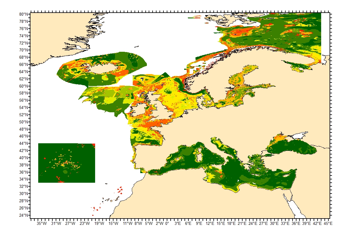
  • Sediment average grain size in the European North-East Atlantic and Mediterranean waters was generated from Euseamap 2023 sediment categories. This rough granulometry estimate may be used for habitat models at meso- and large scale.
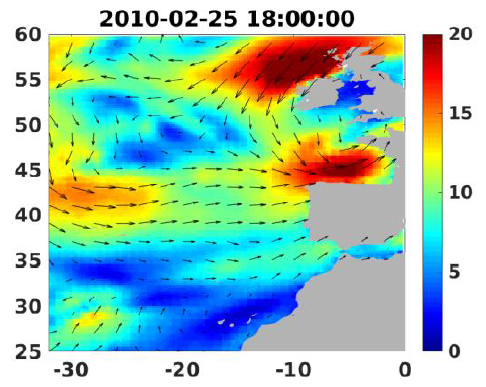
  • Definition of Classified Shellfish Farming Areas. Boundaries are defined by prefectural classification decrees provided to the International Office for Water (OIEau) by the Departmental Offices for Maritime affairs (DDAM) Annual Layer created by OIEau.

  • Cost reductions in nascent forms of Renewable Energy Technology (RET) are essential for them to contribute to the energy mix. Policy intervention can facilitate this cost reduction; however, this may require a significant investment from the public sector. These cost reductions fall into two broad categories: (1) incremental cost reductions through continual improvements to existing technologies, and (2) radical innovation where technologies that significantly differ from the incumbents are developed. This study presents a modelling methodology to integrate radical innovation in RET experience curve and learning investment analysis, using wave energy as an example nascent RET. This aims to quantify the potential effects of radical innovation on the learning investment, allowing the value of successful innovation to be better analysed. The study highlights the value offered by radical innovations in long-term deployment scenarios for wave energy. This suggests that high-risk R&D efforts in nascent RET sectors, even with low success rates, could still present significant expected value in offsetting future revenue support.

  • The Pelagos database is the result of collaborative work by the Réseau des Stations et Observatoires Marins (RESOMAR), now part of the ILICO research infrastructure. It brings together biodiversity data from the coastal pelagic ecosystem (including time series). One of the goals is to exploit the biological information acquired, to answer scientific questions concerning, for example, the factors controlling the distribution and abundance of pelagic organisms at different spatial and time scales.