 Catalogue PIGMA
/Ocean Waves/Significant Wave Height
Type of resources
Topics
Keywords
Contact for the resource
Provided by
Years
Formats
Representation types
status
Resolution
-
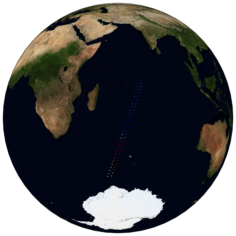
The ESA Sea State Climate Change Initiative (CCI) project has produced global multi-sensor time-series of along-track satellite altimeter significant wave height data (referred to as Level 2P (L2P) data) with a particular focus for use in climate studies. This dataset contains the Version 3 Remote Sensing Significant Wave Height product, which provides along-track data at approximately 6 km spatial resolution, separated per satellite and pass, including all measurements with flags, corrections and extra parameters from other sources. These are expert products with rich content and no data loss. The altimeter data used in the Sea State CCI dataset v3 come from multiple satellite missions spanning from 2002 to 2022021 (Envisat, CryoSat-2, Jason-1, Jason-2, Jason-3, SARAL, Sentinel-3A), therefore spanning over a shorter time range than version 1.1. Unlike version 1.1, this version 3 involved a complete and consistent retracking of all the included altimeters. Many altimeters are bi-frequency (Ku-C or Ku-S) and only measurements in Ku band were used, for consistency reasons, being available on each altimeter but SARAL (Ka band).
-
The ESA Sea State Climate Change Initiative (CCI) project has produced global multi-sensor time-series of along-track satellite altimeter significant wave height data (referred to as Level 4 (L4) data) with a particular focus for use in climate studies. This dataset contains the Version 3 Remote Sensing Significant Wave Height product, gridded over a global regular cylindrical projection (1°x1° resolution), averaging valid and good measurements from all available altimeters on a monthly basis (using the L2P products also available). These L4 products are meant for statistics and visualization. The altimeter data used in the Sea State CCI dataset v3 come from multiple satellite missions spanning from 2002 to 2021 ( Envisat, CryoSat-2, Jason-1, Jason-2, Jason-3, SARAL, Sentinel-3A), therefore spanning over a shorter time range than version 1.1. Unlike version 1.1, this version 3 involved a complete and consistent retracking of all the included altimeters. Many altimeters are bi-frequency (Ku-C or Ku-S) and only measurements in Ku band were used, for consistency reasons, being available on each altimeter but SARAL (Ka band).
-
The ESA Sea State Climate Change Initiative (CCI) project has produced global multi-sensor time-series of along-track satellite synthetic aperture radar (SAR) integrated sea state parameters (ISSP) data from ENVISAT (referred to as SAR Wave Mode onboard ENVISAT Level 2P (L2P) ISSP data) with a particular focus for use in climate studies. This dataset contains the ENVISAT Remote Sensing Integrated Sea State Parameter product (version 1.1), which forms part of the ESA Sea State CCI version 3.0 release. This product provides along-track significant wave height (SWH) measurements at 5km resolution every 100km, processed using the Li et al., 2020 empirical model, separated per satellite and pass, including all measurements with flags and uncertainty estimates. These are expert products with rich content and no data loss. The SAR Wave Mode data used in the Sea State CCI SAR WV onboard ENVISAT Level 2P (L2P) ISSP v3 dataset come from the ENVISAT satellite mission spanning from 2002 to 2012.
-

The ESA Sea State Climate Change Initiative (CCI) project has produced global daily merged multi-sensor time-series of along-track satellite altimeter significant wave height data (referred to as Level 3 (L3) data) with a particular focus for use in climate studies. This dataset contains the Version 4 Remote Sensing Significant Wave Height product, which provides along-track data at approximately 6 km spatial resolution. It has been generated from upstream Sea State CCI L2P products, edited and merged into daily products, retaining only valid and good quality measurements from all altimeters over one day, with simplified content (only a few key parameters). This is close to what is delivered in Near-Real Time by the CMEMS (Copernicus - Marine Environment Monitoring Service) project. It covers the date range from 1991-2023. The altimeter data used in the Sea State CCI dataset v3 come from multiple satellite missions (ERS-1, ERS-2,TOPEX-Poseidon, Envisat, CryoSat-2, Jason-1, Jason-2, Jason-3, SARAL, Sentinel-3 A, Sentinel-3 B, Sentinel-6 A), therefore spanning over a wider time range than previous version 3. The missions already retracked (with WHALES) in version 3 were not reprocessed, but extended when applicable. Many altimeters are bi-frequency (Ku-C or Ku-S) and only measurements in Ku band were used, for consistency reasons, being available on each altimeter but SARAL (Ka band). The version 4 of this dataset now supersedes the previous version 3.
-
The ESA Sea State Climate Change Initiative (CCI) project has produced global daily merged multi-sensor time-series of along-track satellite altimeter significant wave height data (referred to as Level 3 (L3) data) with a particular focus for use in climate studies. This dataset contains the Version 3 Remote Sensing Significant Wave Height product, which provides along-track data at approximately 6 km spatial resolution. It has been generated from upstream Sea State CCI L2P products, edited and merged into daily products, retaining only valid and good quality measurements from all altimeters over one day, with simplified content (only a few key parameters). This is close to what is delivered in Near-Real Time by the CMEMS (Copernicus - Marine Environment Monitoring Service) project. It covers the date range from 2002-2021. The altimeter data used in the Sea State CCI dataset v3 come from multiple satellite missions (Envisat, CryoSat-2, Jason-1, Jason-2, Jason-3, SARAL, Sentinel-3A), therefore spanning over a shorter time range than version 1.1. Unlike version 1.1, this version 3 involved a complete and consistent retracking of all the included altimeters. Many altimeters are bi-frequency (Ku-C or Ku-S) and only measurements in Ku band were used, for consistency reasons, being available on each altimeter but SARAL (Ka band).
-

The ESA Sea State Climate Change Initiative (CCI) project has produced global multi-sensor time-series of along-track satellite altimeter significant wave height data (referred to as Level 2P (L2P) data) with a particular focus for use in climate studies. This dataset contains the Version 4 Remote Sensing Significant Wave Height product, which provides along-track data at approximately 6 km spatial resolution, separated per satellite and pass, including all measurements with flags, bias corrections and extra parameters from other sources. These are expert products with rich content and no data loss. The altimeter data used in the Sea State CCI dataset v4 come from multiple satellite missions spanning from 1992 to 2023 (ERS-1, ERS-2, Envisat, CryoSat-2, Jason-1, Jason-2, Jason-3, SARAL, Sentinel-3 A, Sentinel-3 B, Sentinel-6 A), therefore spanning over a larger time range than the previous version 3. The missions already retracked (with WHALES) in version 3 were not reprocessed, but extended when applicable. Many altimeters are bi-frequency (Ku-C or Ku-S) and only measurements in Ku band were used, for consistency reasons, being available on each altimeter but SARAL (Ka band). **The version 4 of this dataset now supersedes the previous version 3.**
-

The ESA Sea State Climate Change Initiative (CCI) project has produced global multi-sensor time-series of along-track satellite altimeter significant wave height data (referred to as Level 4 (L4) data) with a particular focus for use in climate studies. This dataset contains the Version 4 Remote Sensing Significant Wave Height product, gridded over a global regular cylindrical projection (1°x1° resolution), averaging valid and good measurements from all available altimeters on a monthly basis (using the L2P products also available). These L4 products are meant for statistics and visualization. The altimeter data used in the Sea State CCI dataset v3 come from multiple satellite missions spanning from 1992 to 2023 (ERS-1, ERS-2,TOPEX-Poseidon, Envisat, CryoSat-2, Jason-1, Jason-2, Jason-3, SARAL, Sentinel-3 A, Sentinel-3 B, Sentinel-6 A), therefore spanning over a wider time range than the previous version 3. The missions already retracked (with WHALES) in version 3 were not reprocessed, but extended when applicable. Many altimeters are bi-frequency (Ku-C or Ku-S) and only measurements in Ku band were used, for consistency reasons, being available on each altimeter but SARAL (Ka band).
-
The ESA Sea State Climate Change Initiative (CCI) project has produced global multi-sensor time-series of along-track satellite synthetic aperture radar (SAR) integrated sea state parameters (ISSP) data from Sentinel-1 (referred to as SAR WV onboard Sentinel-1 Level 2P (L2P) ISSP data) with a particular focus for use in climate studies. This dataset contains the Sentinel-1 SAR Remote Sensing Integrated Sea State Parameter product (v1.0), which forms part of the ESA Sea State CCI version 3.0 release. This product provides along-track primary significant wave height measurements and secondary sea state parameters, calibrated with CMEMS model data and reference in situ measurements at 20km resolution every 100km, processed using the Pleskachevsky et. al., 2021 emprical model, separated per satellite and pass, including all measurements with flags and uncertainty estimates. These are expert products with rich content and no data loss. The SAR Wave Mode data used in the Sea State CCI SAR WV onboard Sentinel-1 Level 2P (L2P) ISSP v3 dataset come from the Sentinel-1 satellite missions spanning from 2014 to 2021 (Sentinel-1 A, Sentinel-1 B).
-

The ESA Sea State Climate Change Initiative (CCI) project has produced global multi-sensor time-series of along-track satellite synthetic aperture radar (SAR) significant wave height (SWH) data (referred to as SAR WV onboard Sentinel-1 Level 2P (L2P) SWH data) with a particular focus for use in climate studies. This dataset contains the Sentinel-1 SAR Remote Sensing Significant Wave Height product (version 1.0), which is part of the ESA Sea State CCI Version 3.0 release. This product provides along-track SWH measurements at 20km resolution every 100km, processed using the Quach et al statistical model , separated per satellite and pass, including all measurements with flags, corrections and extra parameters from other sources. These are expert products with rich content and no data loss. The SAR Wave Mode data used in the Sea State CCI dataset v3 come from Sentinel-1 satellite missions spanning from 2015 to 2021 (Sentinel-1 A, Sentinel-1 B).
-
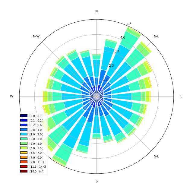
The main objective of the SWIM Level 3 (L3) product is to provide global gridded wave statistics from the along-track directional wave spectra measures, as observed with SWIM instrument onboard CFOSAT. CFOSAT (Chinese French Ocean SATellite) is a french-chinese mission launched in 2018, whose aim is to provide wind (SCAT instrument) and wave (SWIM instrument) measurements over the sea surface. The processing uses the integrated parameters (wave length, significant wave height, direction) of the wave systems associated with the individual partitions retrieved from SWIM wave spectra, computing monthly statistics such as distribution, min, max, mean and median over a global 2 degree resolution grid. Three sub-products are generated separately for each SWIM beam (from 4° to 10°) from respectively the SWIM Level 2 spectra produced by the CWWIC center (CNES), the SWIM Level 2S spectra produced by the IWWOC center (Ifremer) and forecast spectra produced from WaveWatch3 wave model at Ifremer as an independent source for comparison. The SWIM level 3 dataset is generated in delayed mode. It is currently mainly meant as a validation dataset aiming at inter-comparing the different SWIM Level 2 between each other, with an independent model (here WaveWatch3) or other external similar wave statistics products. The SWIM L3 dataset is generated and distributed by Ifremer / CERSAT in the frame of the Ifremer Wind and Wave Operation Center (IWWOC) co-funded by Ifremer and CNES and dedicated to the processing of the delayed mode data of CFOSAT mission.