 Catalogue PIGMA
Ocean
Type of resources
Available actions
Topics
Keywords
Contact for the resource
Provided by
Years
Formats
-
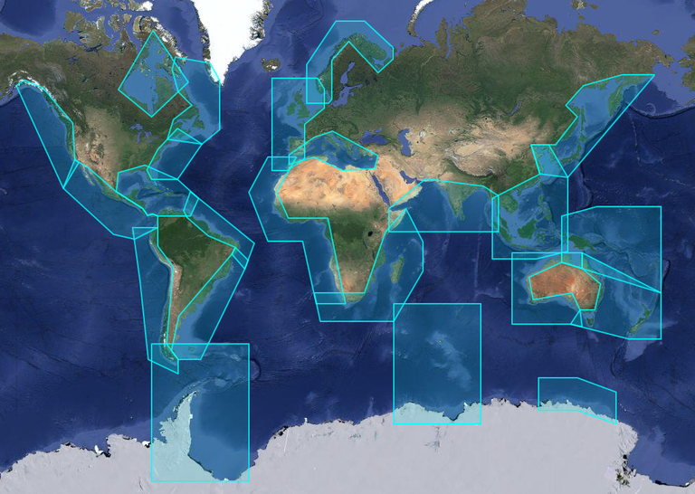
X-TRACK, is a regional altimeter products for coastal applications. It has been developed in order to optimize the completeness and the accuracy of the sea surface height information derived from satellite altimetry in coastal ocean areas. 1hz alongtrack SLA are available in 23 regions for different altimetric missions (Topex, Jason-1&2, Geosat, Ers2, Envisat). SLA is computed on a reference track. X-TRACK SLA files hold alongtrack SLA data together with MSSH, FES2012 tide, Dynamic Atmospheric Corrections and distance to coast parameters. Users can both retrieve filtered and non-filtered data. X-TRACK areas : | short name | long name | |:------------|:---------------------------------| | adelie | Adelie-Mertz | | amazon | Amazon | | asa | Atlantic South America | | chinasea | China Sea | | drake | Drake passage | | eaustralia | East Australia | | gom | Gulf of Mexico - Caribbean Sea | | gulfstream | Gulf Stream | | hudson | Hudson Bay | | humboldt | Humboldt current | | kerguelen | Kerguelen Islands | | labrador | Labrador Sea | | medsea | Mediterranean Sea | | nea | North East Atlantic | | nindian | North Indian Ocean | | norway | Norway | | nwa | North West America | | nwp | North West Pacific | | sea | South and East Africa | | wafrica | West Africa | | waustralia | West Australia | | wla | West Latin America - California | | wtp | West Tropical Pacific |
-
X-TRACK, is a regional altimeter products for coastal applications. Along-track tidal constants (amplitude, phase lags and associated estimation errors for 73 constituents) derived from the X-TRACK T/P and Jason 1&2 is available every 6-7 km along the satellite ground tracks. X-TRACK areas : | short name | long name | |:------------|:---------------------------------| | adelie | Adelie-Mertz | | amazon | Amazon | | asa | Atlantic South America | | chinasea | China Sea | | drake | Drake passage | | eaustralia | East Australia | | gom | Gulf of Mexico - Caribbean Sea | | gulfstream | Gulf Stream | | hudson | Hudson Bay | | humboldt | Humboldt current | | kerguelen | Kerguelen Islands | | labrador | Labrador Sea | | medsea | Mediterranean Sea | | nea | North East Atlantic | | nindian | North Indian Ocean | | norway | Norway | | nwa | North West America | | nwp | North West Pacific | | sea | South and East Africa | | wafrica | West Africa | | waustralia | West Australia | | wla | West Latin America - California | | wtp | West Tropical Pacific |
-
X-TRACK, is a regional altimeter products for coastal applications. It has been developed in order to optimize the completeness and the accuracy of the sea surface height information derived from satellite altimetry in coastal ocean areas. 1hz alongtrack SLA are available in 23 regions for different altimetric missions (Topex, Jason-1&2, Geosat, Ers2, Envisat). SLA is computed on a reference track. X-TRACK SLA files hold alongtrack SLA data together with MSSH, FES2012 tide, Dynamic Atmospheric Corrections and distance to coast parameters. Users can both retrieve filtered and non-filtered data. X-TRACK areas : | short name | long name | | :----------------- | :---------------------------------- | | adelie | Adelie-Mertz | | amazon | Amazon | | asa | Atlantic South America | | chinasea | China Sea | | drake | Drake passage | | eaustralia | East Australia | | gom | Gulf of Mexico - Caribbean Sea | | gulfstream | Gulf Stream | | hudson | Hudson Bay | | humboldt | Humboldt current | | kerguelen | Kerguelen Islands | | labrador | Labrador Sea | | medsea | Mediterranean Sea | | nea | North East Atlantic | | nindian | North Indian Ocean | | norway | Norway | | nwa | North West America | | nwp | North West Pacific | | sea | South and East Africa | | wafrica | West Africa | | waustralia | West Australia | | wla | West Latin America - California | | wtp | West Tropical Pacific |
-
Climatology of near-inertial currents. Global climatology of near-inertial current characteristics from satellite-tracked drifters. Data analysed : 8500 near-surface satellite-tracked drifter trajectories with drogues attached at 15 m depth.
-
Ocean tide and loading altimetric corrections computed - with SIROCCO Tools : https://sirocco.obs-mip.fr/other-tools/prepost-processing/comodo-tools - from FES2014 atlases : https://doi.org/10.6096/3001 - for all altimetric missions. Validation available at ftp://ftp.legos.obs-mip.fr/pub/ecola/FES2014/CTOH/2021-02-diff-libfes-tools.pdf
-
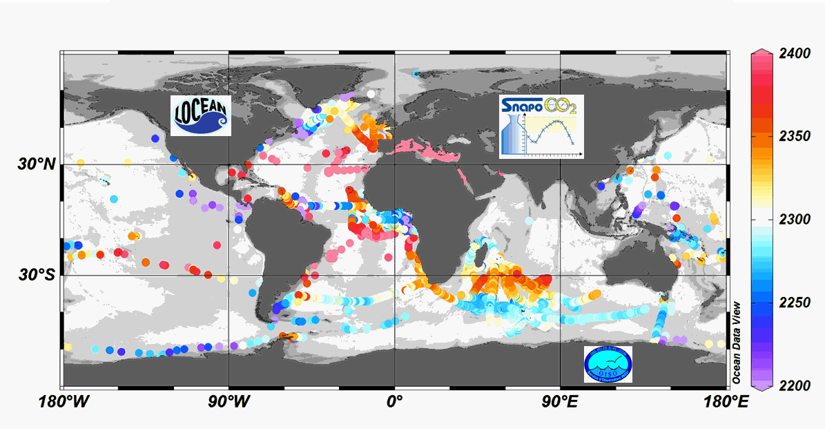
Since 2004, the Service facility SNAPO-CO2 (Service National d’Analyse des Paramètres Océaniques du CO2) housed by the LOCEAN laboratory (Paris, France) has been in charge for the analysis of Total Alkalinity (AT) and Total dissolved inorganic carbon (CT) of seawater samples on a series of cruises or ships of opportunity conducted in different regions in the frame of French projects. More than 44000 observations are synthetized in this work. Sampling was performed either from CTD-Rosette casts (Niskin bottles) or collected from the ship’s seawater supply (intake at about 5m depth). After completion of each cruise, discrete samples were returned back at LOCEAN laboratory and stored in a dark room at 4 °C before analysis generally within 2-3 months after sampling (sometimes within a week). AT and CT were analyzed simultaneously by potentiometric titration using a closed cell (Edmond, 1970). Certified Reference Materials (CRMs) provided by Pr. A. Dickson (Scripps Institution of Oceanography, San Diego, USA) were used to calibrate the measurements. The same instrumentation was used for underway measurements during OISO cruises (https://doi.org/10.18142/228) and OISO AT-CT data for 1998-2018 in the South Indian Ocean added in this synthesis. The synthesis is organized in two files (one for Global ocean and the Coastal Zones, one for the Mediterranean Sea) with the same format: Cruise name, Ship name, day, month, year, hour, minute, second, latitude, longitude, depth, AT (µmol/kg), Flag-AT, CT (µmol/kg), Flag-CT, Temperature (°C), Flag-Temp, Salinity (PSU), Flag-Salinity, nsample/cruise, nsample on file, sampling method.
-
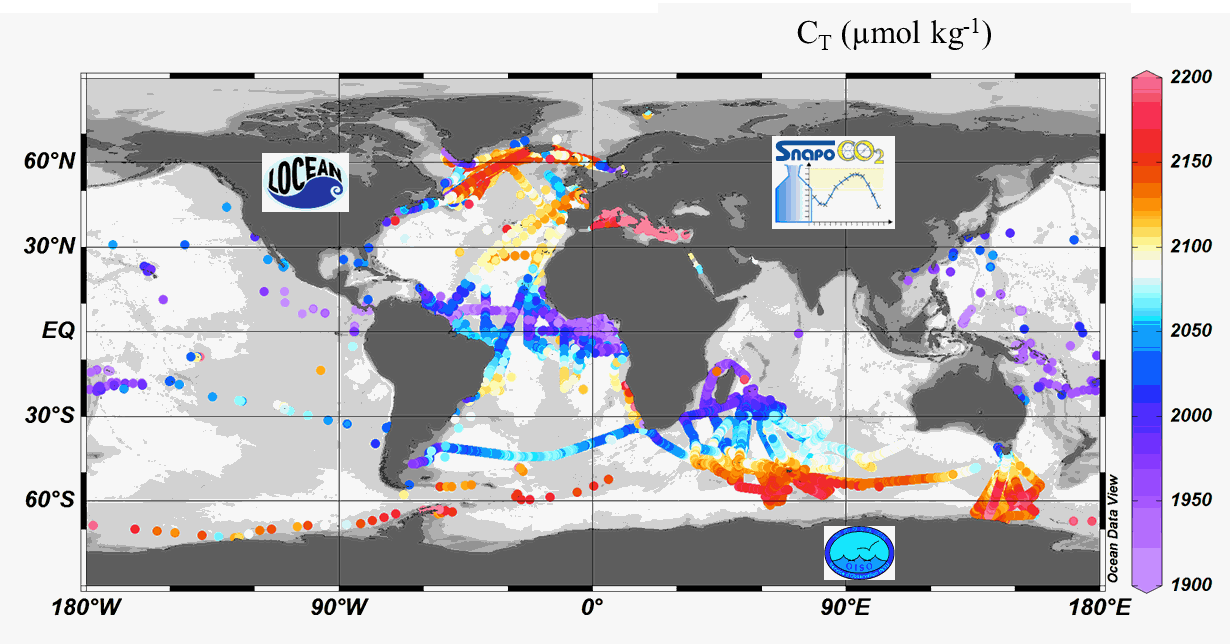
Since 2004, the Service facility SNAPO-CO2 (Service National d’Analyse des Paramètres Océaniques du CO2) housed by the LOCEAN laboratory (Paris, France) has been in charge for the analysis of Total Alkalinity (AT) and Total dissolved inorganic carbon (CT) of seawater samples on a series of cruises or ships of opportunity conducted in different regions in the frame of French and International projects. Following the first synthesis (Metzl et al, 2024, https://doi.org/10.17882/95414), 24700 new data have been quality controlled and the second version includes more than 67000 observations over 1993-2023. Sampling was performed either from CTD-Rosette casts (Niskin bottles) or collected from the ship’s seawater supply (intake at about 5m depth). After completion of each cruise, discrete samples were returned back at LOCEAN laboratory and stored in a dark room at 4 °C before analysis generally within 2-3 months after sampling (sometimes within a week). AT and CT were analyzed simultaneously by potentiometric titration using a closed cell (Edmond, 1970). Certified Reference Materials (CRMs) provided by Pr. A. Dickson (Scripps Institution of Oceanography, San Diego, USA) were used to calibrate the measurements. The same instrumentation was used for underway measurements during OISO cruises (https://campagnes.flotteoceanographique.fr/series/228/) and MINERVE cruises (https://doi.org/10.18142/128) and new AT-CT data for 2002-2021 in the Indian Ocean and Southern Ocean added in this synthesis. The second dataset is organized in one file with the format: Cruise name, Ship name, day, month, year, hour, minute, second, latitude, longitude, depth, AT (µmol/kg), Flag-AT, CT (µmol/kg), Flag-CT, Temperature (°C), Flag-Temp, Salinity (PSU), Flag-Salinity, nsample/cruise, sampling method, Version number, nsample on file.