 Catalogue PIGMA
/Physical oceanography/Water column temperature and salinity
Type of resources
Available actions
Topics
Keywords
Contact for the resource
Provided by
Years
Formats
Representation types
Update frequencies
status
Scale
Resolution
-

NOAA High-resolution Blended Analysis of Daily SST and Ice. Data is from Sep 1981 and is on a 1/4 deg global grid.
-
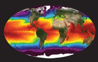
NASA's Physical Oceanography Distributed Active Archive Center (PO.DAAC) is located at NASA's Jet Propulsion Laboratory in Pasadena, California. PO.DAAC manages and provides tools and services for NASA's oceanographic and hydrologic data (satellite, airborne, and in-situ) to enable a greater understanding of the physical processes and conditions of the global ocean. Measurements include gravity, ocean winds, sea surface temperature, ocean surface topography, sea surface salinity, and circulation. The data support a wide range of applications including climate research, weather prediction, resource management, policy, and the stewardship of ocean data resources.
-
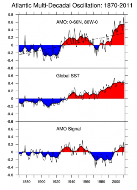
The Atlantic Multi-decadal Oscillation (AMO) has been identified as a coherent mode of natural variability occurring in the North Atlantic Ocean with an estimated period of 60-80 years. It is based upon the average anomalies of sea surface temperatures (SST) in the North Atlantic basin, typically over 0-80N. To remove the climate change signal from the AMO index, users typically detrend the SST data at each gridpoint or detrend the spatially averaged time series. Trenberth and Shea (2006) recommend that the detrending be done by subtracting the global-mean SST anomaly time series from the spatially averaged time series. See the Expert Guidance by Dr. Kevin Trenberth for the rationale for the global-mean detrending approach. The Expert Guidance by Dr. Rong Zhang discusses the impacts and mechanisms of the AMO.
-

NCAR was established by the National Science Foundation in 1960 to provide the university community with world-class facilities and services that were beyond the reach of any individual institution. More than a half-century later, we are still delivering on that mission. NCAR provides the atmospheric and related Earth system science community with state-of-the-art resources, including supercomputers, research aircraft, sophisticated computer models, and extensive data sets. From its founding, NCAR was meant to provide the atmospheric research community with the shared resources necessary to work on the most important scientific problems of the day. Not much has changed. The hundreds of scientists who work here research all things atmospheric — which includes everything from the microphysics of cloud formation and the chemistry of air pollution to large-scale planetary waves and the impact of increased greenhouse gases on our climate. Since the atmosphere interacts with everything it touches, its crucial to investigate those interactions, too.
-
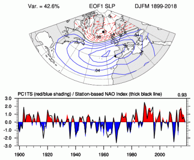
The principal component (PC)-based indices of the North Atlantic Oscillation (NAO) are the time series of the leading Empirical Orthogonal Function (EOF) of SLP anomalies over the Atlantic sector, 20°-80°N, 90°W-40°E. These indices are used to measure the NAO throughout the year, tracking the seasonal movements of the Icelandic low and Azores high. These movements are illustrated in the Figures on this page. Positive values of the NAO index are typically associated with stronger-than-average westerlies over the middle latitudes, more intense weather systems over the North Atlantic and wetter/milder weather over western Europe.
-

The European Marine Observation and Data Network (EMODnet) is a long-term, marine-data initiative funded by the European Maritime and Fisheries Fund which, together with the Copernicus space programme and the Data Collection Framework for fisheries, implements the EU’s Marine Knowledge 2020 strategy. EMODnet Physics (www.emodnet-physics.eu) is one of the seven domain-specific portals of the European Marine Observation and Data Network (EMODnet). EMODnet-Physics map portal (www.emodnet-physics.eu/map) provides a single point of access to validated in situ datasets, products and their physical parameter metadata of European Seas and global oceans. More specifically, time series and datasets are made available, as recorded by fixed platforms (moorings, tide gauges, HF radars, etc.), moving platforms (ARGO, Lagrangian buoys, ferryboxes, etc.) and repeated observations (CTDs, etc.). The available themes are the temperature of the water column, the salinity of the water column, horizontal velocity of the water column, sea level and sea level trends, wave height and period, wind and atmospheric pressure, optical properties (e.g. light attenuation, back scattering, turbidity, etc.), underwater sound pressure level (acoustic pollution), river runoff, other biogeochemical data (e.g. chlorophyll, dissolved oxygen, etc.), sea-ice coverage. Acquisition of these physical parameters is largely an automated process based on a “federated” network infrastructure linking data providers and other marine data aggregating infrastructure. In particular, EMODnet Physics is strongly federated with two other European data aggregating infrastructures. One is the Copernicus Marine Environment Monitoring Service - In Situ Thematic Assembly Centre for operational data flow, while historical validated datasets are organised in collaboration with SeaDataNet and its network of National Oceanographic Data Centres. The NRT data go through a stricter quality control before NODCs validate the datasets for long-term storage and stewardship. This validation process ends when the metadata of the processed dataset are published in a CDI (Common Data Index). CMEMS-INSTAC and SDN-NODC subsets are integrated with other available sources to make the most comprehensive physical parameter data catalogues available. Thanks to international collaborative relationships to provide data access to – and preview for – coastal data in non-European areas (e.g. NOAA platforms for the US, IAPB platforms for the Arctic area, IMOS for Australia and others), EMODnet Physics catalogues are going beyond European borders to offer an even more exhaustive entry point to global-ocean physical observations.
-

The Copernicus Marine Service (or Copernicus Marine Environment Monitoring Service) is the marine component of the Copernicus Programme of the European Union. It provides free, regular and systematic authoritative information on the state of the Blue (physical), White (sea ice) and Green (biogeochemical) ocean, on a global and regional scale. It is funded by the European Commission (EC) and implemented by Mercator Ocean International. It is designed to serve EU policies and International legal Commitments related to Ocean Governance, to cater for the needs of society at large for global ocean knowledge and to boost the Blue Economy across all maritime sectors by providing free-of-charge state-of-the-art ocean data and information. It provides key inputs that support major EU and international policies and initiatives and can contribute to: combating pollution, marine protection, maritime safety and routing, sustainable use of ocean resources, developing marine energy resources, blue growth, climate monitoring, weather forecasting, and more. It also aims to increase awareness amongst the general public by providing European and global citizens with information about ocean-related issues.
-
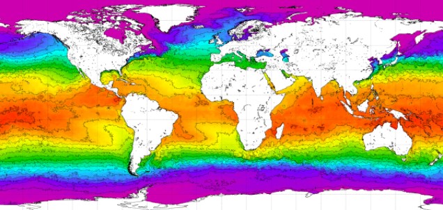
World Ocean Atlas 2018 (WOA18) is a set of objectively analyzed (one degree grid and quarter degree grid) climatological fields of in situ temperature, salinity, dissolved oxygen, Apparent Oxygen Utilization (AOU), percent oxygen saturation, phosphate, silicate, and nitrate at standard depth levels for annual, seasonal, and monthly compositing periods for the World Ocean. Quarter degree fields are for temperature and salinity only. It also includes associated statistical fields of observed oceanographic profile data interpolated to standard depth levels on quarter degree, one degree, and five degree grids. Temperature and salinity fields are available for six decades (1955-1964, 1965-1974, 1975-1984, 1985-1994, 1995-2004, and 2005-2017) an average of all decades representing the period 1955-2017, as well as a thirty year "climate normal" period 1981-2010. Oxygen fields (as well as AOU and percent oxygen saturation) are available using all quality controlled data 1960-2017, nutrient fields using all quality controlled data from the entire sampling period 1878-2017. This accession is a product generated by the National Centers for Environmental Information's (NCEI) Ocean Climate Laboratory Team. The analyses are derived from the NCEI World Ocean Database 2018.
-

Several climate indices, regarding Atlantic Basin: - North Atlantic Oscillation - Southern Oscillation Index - Bivariate ENSO Timeseries - Tropical Northern Atlantic Index - Tropical Southern Atlantic Index - Oceanic Niño Index - Multivariate ENSO Index (MEI V2) - North Tropical Atlantic SST Index - ENSO precipitation index - Northeast Brazil Rainfall Anomaly - Solar Flux (10.7cm) - Global Mean Lan/Ocean Temperature
-
The Joint WMO-IOC Technical Commission for Oceanography and Marine Meteorology Observing Programmes Support Centre, provides technical coordination at international level for the sustained elements of the Global Ocean Observing System. The Centre monitors in real-time the status of the observing networks and provides a toolbox to evaluate their performance and optimize their implementation and data flow. Currently OceanOPS monitors the Argo profiling floats, the DBCP surface drifters, coastal and tropical moorings, ice buoys, tsunami buoys, the OceanSITES moorings time-series, the GO-SHIP hydrographic reference lines, the SOT mat/ocean ship based observations and the GLOSS sea level tide gauges. A number of other observing systems are being added gradually, including ocean gliders, polar systems, marine mammals and potentially HF radars.