 Catalogue PIGMA
D6: Sea-floor Integrity
Type of resources
Available actions
Topics
Keywords
Contact for the resource
Provided by
Years
Formats
Representation types
Update frequencies
status
Scale
-
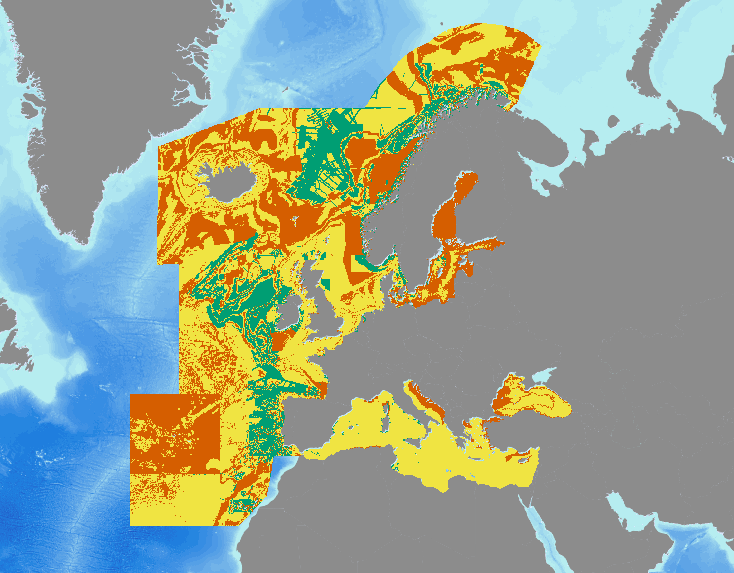
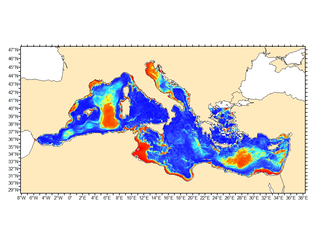
Confidence in the full output of the 2016 EUSeaMap broad-scale predictive model, produced by EMODnet Seabed Habitats. Values are on a range from 1 (low confidence) to 3 (high confidence). Confidence is calculated by amalgamating the confidence values of the underlying applicable habitat descriptors used to generate the habitat value in the area in question. Habitat descriptors differ per region but include: Biological zone Energy class Oxygen regime Salinity regime Seabed Substrate Riverine input Confidence in habitat descriptors are driven by the confidence in the source data used to determine the descriptor, and the confidence in the threshold/margin (areas closer to a boundary between two classes will have lower confidence). Confidence values are also available for each habitat descriptor and input data layer.
-
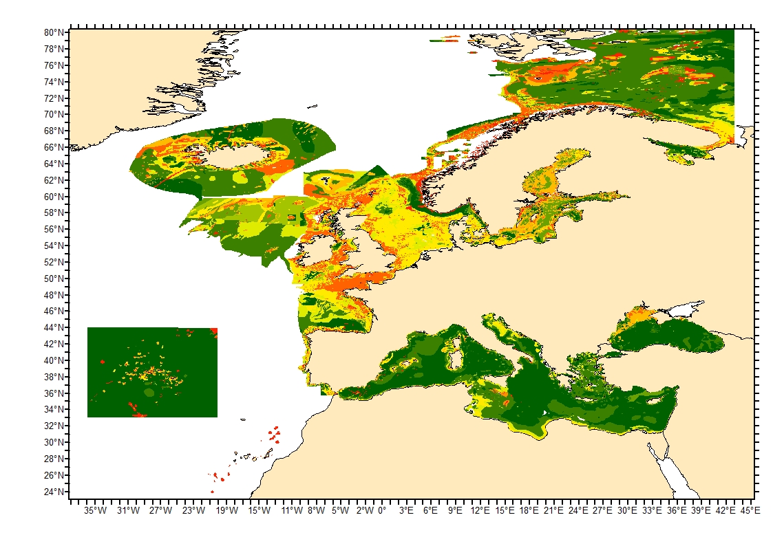
Sediment average grain size in the European North-East Atlantic and Mediterranean waters was generated from Euseamap 2023 sediment categories. This rough granulometry estimate may be used for habitat models at meso- and large scale.
-
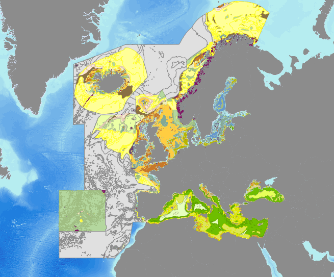
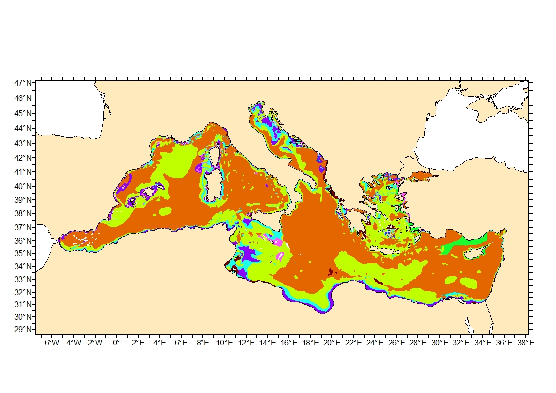
Output of the 2016 EUSeaMap broad-scale predictive model, produced by EMODnet Seabed Habitats. The extent of the mapped area includes the Mediterranean Sea, Black Sea, Baltic Sea, and areas of the North Eastern Atlantic extending from the Canary Islands in the south to Norway in the North. The map was produced using a "top-down" modelling approach using classified habitat descriptors to determine a final output habitat. Habitat descriptors differ per region but include: Biological zone Energy class Oxygen regime Salinity regime Seabed Substrate Riverine input Habitat descriptors (excepting Substrate) are calculated using underlying physical data and thresholds derived from statistical analyses or expert judgement on known conditions. The model is produced in Arc Model Builder (10.1). For more information on the modelling process please read the EMODnet Seabed Habitats The model was created using raster input layers with a cell size of 0.002dd (roughly 250 meters). The model includes the sublittoral zone only; due to the high variability of the littoral zone, a lack of detailed substrate data and the resolution of the model, it is difficult to predict littoral habitats at this scale. The map follows the EUNIS 2007-11 classification system where it is appropriate.
-
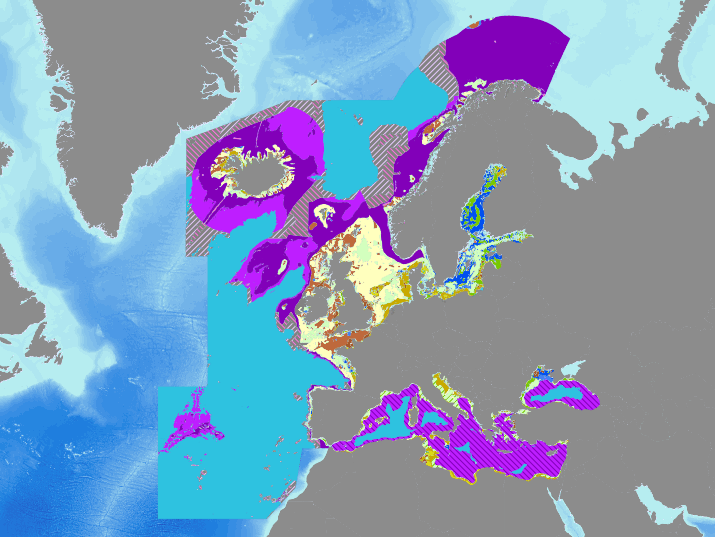
Output of the 2016 EUSeaMap broad-scale predictive model, produced by EMODnet Seabed Habitats and aggregated into the predominant habitats of the Marine Strategy Framework Directive. The extent of the mapped area includes the Mediterranean Sea, Black Sea, Baltic Sea, and areas of the North Eastern Atlantic extending from the Canary Islands in the south to Norway in the North. The map was produced using a "top-down" modelling approach using classified habitat descriptors to determine a final output habitat. Habitat descriptors differ per region but include: Biological zone Energy class Oxygen regime Salinity regime Seabed Substrate Riverine input Habitat descriptors (excepting Substrate) are calculated using underlying physical data and thresholds derived from statistical analyses or expert judgement on known conditions. The model is produced in Arc Model Builder (10.1). For more information on the modelling process please read the EMODnet Seabed Habitats The model was created using raster input layers with a cell size of 0.002dd (roughly 250 meters). The model includes the sublittoral zone only; due to the high variability of the littoral zone, a lack of detailed substrate data and the resolution of the model, it is difficult to predict littoral habitats at this scale.
-
Sediment average grain size in the Mediterranean was generated from sediment categories. This rough granulometry estimate may be used for habitat models at meso- and large scale.
-
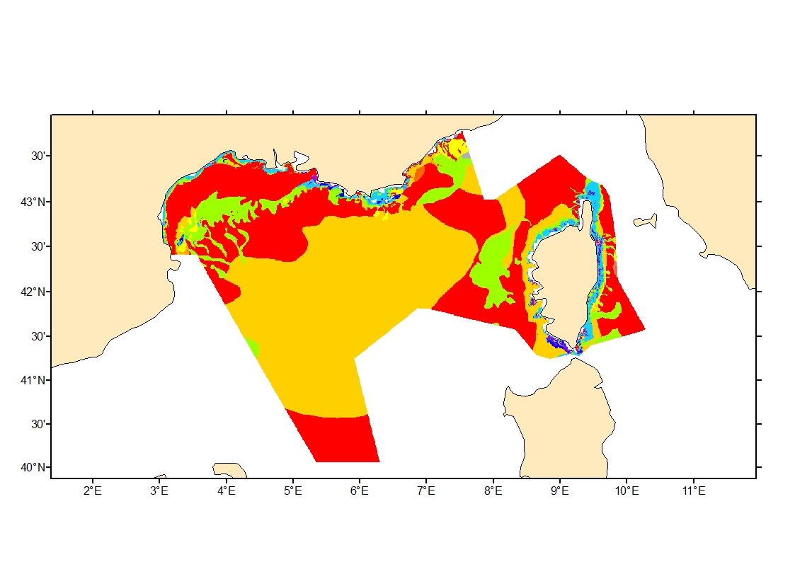
Sediment average grain size in French Mediterranean waters was generated from sediment categories. This rough granulometry estimate may be used for habitat models at meso- and large scale.
-
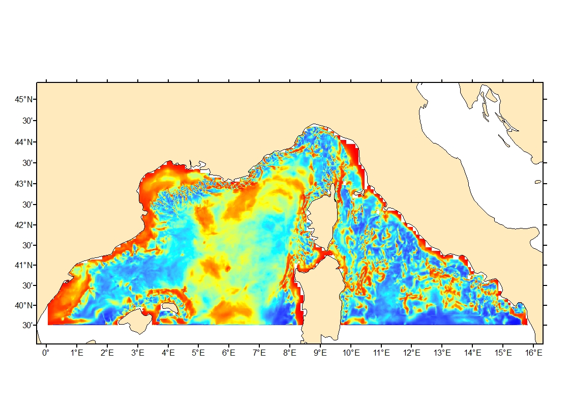
Seabed shear stress (in N.m-2) is a measure of the friction of water on the seabed due to waves and currents. The 90th percentile over the available period is used as layer for habitat models prediction.
-
Seabed shear stress (in N.m-2) is a measure of the friction of water on the seabed due to waves and currents. The 90th percentile over the available period is used as layer for habitat models prediction.
-
The land-sea limit corresponds to the Highest Astronomical Tide (HAT) in the case of a tide of coefficient 120 and under normal meteorological conditions (no offshore wind and mean atmospheric pressure of 1013 hPa). This geometric line is naturally defined as the intersection of a HAT model (extended to the coast and the top end of the upper estuary) based on the available Bathyelli surfaces, and a high-resolution digital terrain model of the coastal area. It corresponds to the highest limit of the intertidal area and takes into account, when they exist, the 3 administrative maritime limits which are: the transversal limit of the sea (LTM), the salt water limit (LSE) and the limit of maritime jurisdiction (LAM). This limit is measured (quoted) in relation to the local hydrographic chart datum and to the levels of reference for France (IGN69 and IGN78 for Corsica). Relations to other levels of reference (mean sea level and ellipsoid) are known. The land-sea limit product, mainly results from the exploitation of the two products Litto3D®/RGEALTI® and Bathyelli, and represents, with a metric resolution (1 to 5 metres), this theoretical entity by a set of 2D polylines describing the nature of the coast (artificial or natural, rocky or sandy, steep or flat, etc.). The method used for calculating the land-sea limit makes it possible to produce a continuous, homogeneous and spatially coherent limit on the entire French metropolitan coastal area.