 Catalogue PIGMA
Atlantic
Type of resources
Available actions
Topics
Keywords
Contact for the resource
Provided by
Years
Formats
Representation types
Scale
-
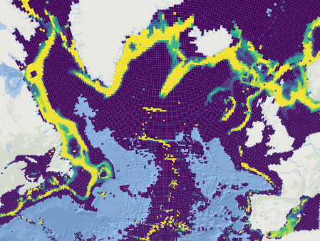
This dataset was built to feed a basin-wide spatial conservation planning exercise, targeting the deep sea of the North Atlantic, in the framework of the ATLAS H2020 project. This approach aimed to inform Marine Spatial Planning and conservation initiatives for the deep sea of the North Atlantic, by identifying conservation priority areas for the Vulnerable Marine Ecosystems (VMEs) and deep fish species and discussing the efficiency of the current spatial management context relatively to conservation stakes. This publication provides (1) the links to spatial datasets used as an input, (2) the R scripts used to run the final conservation scenarios together with associated table of targets and connectivity matrix, that can be run on the input data, and (3) the outputs of the final scenarios constructed and computed for ATLAS. Produced by IFREMER. This output reflects the authors’ views and the European Union is not responsible for any use that may be made of the information it contains. Please note that you use these data at your own risk. No warranty is expressed or implied and no liability is accepted for any inconveniences or damages that may ensue from their use.
-

The ORHAGO campaigns (Observation of the benthic aquatic resources of the Golfe de Gascogne) are designed to collect data on the composition, distribution and change in relative abundance of benthic fish fauna on the continental shelf (depth <100m) in November to December on a yearly basis. The ORHAGO survey was initiated in 2007 with the objective of developing a fishery-independent abundance index for flatfish species, with a particular focus on the common sole (Solea solea) of the Bay of Biscay. In accordance with the ICES-agreed gear for flatfish abundance surveys, ORHAGO employs a 4-meter-beam trawl with a chain mat, 50-millimeter mesh in the net, and 40-millimeter mesh in the cod-end. The sampling plan was designed to ensure full coverage of the common sole habitat in the Bay of Biscay during a period (November-December) for which fish behavior and distribution was suitable for obtaining an unbiased abundance index (young fish move offshore when coastal waters become colder and before the concentrations of the spawning season). The sampling design is a systematic sampling with 49 reference stations. The sampling design was validated in 2013 by the ICES Working Group on Beam Trawl Surveys (WGBEAM). Since 2013, the ORHAGO survey has been used to assess the status of the Bay of Biscay common sole stock (WGBIE, Working Group for the Bay of Biscay and the Iberian Waters Ecoregion).
-

This dataset was built to feed a basin-wide spatial conservation planning exercise, targeting the deep sea of the North Atlantic, in the framework of the ATLAS H2020 project. This approach aimed to inform Marine Spatial Planning and conservation initiatives for the deep sea of the North Atlantic, by identifying conservation priority areas for the Vulnerable Marine Ecosystems (VMEs) and deep fish species and discussing the efficiency of the current spatial management context relatively to conservation stakes. This publication provides (1) the links to spatial datasets used as an input, (2) the R scripts used to run the final conservation scenarios together with associated table of targets and connectivity matrix, that can be run on the input data, and (3) the outputs of the final scenarios constructed and computed for ATLAS. Produced by IFREMER.
-
World list of seaports. In its 2021 version, the repository includes 13709 ports for 187 countries. The list of seaports has been drawn up on the basis of the information available in the European reference system of places used in the framework of the Common Fisheries Policy and, more particularly, by the Electronic Recording and Reporting System (ERS), the list of ports identified by the UNECE (2021-1). An assessment of the infrastructures present along the coastline made it possible to identify other ports that were not listed. Each geographical position has been verified with Google Earth in WGS84. Each port is associated with information relating to the country (ISO 3 coding), the UNECE or ERS 5-character coding, the name, the geographical position in WGS84 (latitude and longitude), the status of the port indicating whether it is referenced by Unece (UNECE), by the EU/ERS (ERS) or by both (UNECE/ERS) In case the port is not referenced by UNECE or ERS, the status is N/A. For French ports, the reference system integrates the ports of the French overseas departments and territories with the national codification. Inland ports have also been integrated in 2021.