 Catalogue PIGMA
NASA/JPL/PODAAC
Type of resources
Keywords
Contact for the resource
Provided by
Years
Formats
status
Resolution
-
These files contain NASA produced skin sea surface temperature (SST) products from the Infrared (IR) channels of the Visible and Infrared Imager/Radiometer Suite (VIIRS) onboard the Suomi-NPP satellite. VIIRS is a multi-disciplinary instrument that is also being flown on the Joint Polar Satellite System (JPSS) series of spacecraft, of which NOAA-20 is the first. JPSS is a multi-agency program that consolidates the polar orbiting spacecraft of NASA and the National Oceanic and Atmospheric Administration (NOAA). Suomi-NPP is the initial spacecraft in this series, and VIIRS is the successor to MODIS for Earth science data. VIIRS has 22 spectral bands ranging from 412 nm to 12 micron . There are 16 moderate-resolution bands (750m at nadir), 5 image-resolution bands (375 m), and one day-night band (DNB). VIIRS uses on-board pixel aggregation to reduce the growth in size of pixels away from nadir. Two SST products are contained in these files. The first is a skin SST produced separately for day and night observations, derived from the long wave IR 11 and 12 micron wavelength channels, using a modified nonlinear SST algorithm intended to provide continuity of SST products from heritage and current NASA sensors. At night, a second triple channel SST product is generated using the 3.7 , 11 and 12 micron IR channels, identified as SST_triple. Due to the sun glint in the 3.7 micron SST_triple can only be used at night. VIIRS L2P SST data have a 750 spatial resolution at nadir and are stored in ~288 five minute granules per day. Full global coverage is obtained each day. The production of VIIRS NASA L2P SST files is part of the Group for High Resolution Sea Surface Temperature (GHRSST) project and is a joint collaboration between the NASA Jet Propulsion Laboratory (JPL), the NASA Ocean Biology Processing Group (OBPG), and the Rosenstiel School of Marine and Atmospheric Science (RSMAS). Researchers at RSMAS were responsible for sea surface temperature algorithm development, error statistics and quality flagging, while the OBPG, as the NASA ground data system, is responsible for the production of VIIRS ocean products. JPL acquires VIIRS ocean granules from the OBPG and reformats them to the GHRSST L2P netCDF specification with complete metadata and is the official Physical Oceanography Data Archive (PO.DAAC) for SST. In mid-August, 2018, the RSMAS involvement in the VIIRS SST project ceased, and the subsequent fields are not maintained.The R2016.2 supersedes the previous v2016.0 datasets which can be found at https://doi.org/10.5067/GHVRS-2PN16
-
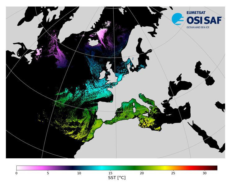
Level 3, four times a day, sub-skin Sea Surface Temperature derived from AVHRR on Metop satellites and VIIRS or AVHRR on NOAA and NPP satellites, over North Atlantic and European Seas and re-projected on a polar stereographic at 2 km resolution, in GHRSST compliant netCDF format. This catalogue entry presents NOAA-19 North Atlantic Regional Sea Surface Temperature. SST is retrieved from infrared channels using a multispectral algorithm and a cloud mask. Atmospheric profiles of water vapor and temperature from a numerical weather prediction model, Sea Surface Temperature from an analysis, together with a radiative transfer model, are used to correct the multispectral algorithm for regional and seasonal biases due to changing atmospheric conditions. The quality of the products is monitored regularly by daily comparison of the satellite estimates against buoy measurements. The product format is compliant with the GHRSST Data Specification (GDS) version 2.Users are advised to use data only with quality levels 3,4 and 5.
-

Level 2 skin Sea Surface Temperature derived from IASI on Metop, global and provided in full-resolution swath (12 km at nadir to 40 km), in GHRSST compliant netCDF format. SST is retrieved using a multispectral algorithm and a cloud mask. Atmospheric profiles of water vapor and temperature from a numerical weather prediction model, Sea Surface Temperature from an analysis, together with a radiative transfer model, are used to correct the multispectral algorithm for regional and seasonal biases due to changing atmospheric conditions. The quality of the products is monitored regularly by daily comparison of the satellite estimates against buoy measurements. The product format is compliant with the GHRSST Data Specification (GDS) version 2. Users are advised to use data only with quality levels 3, 4 and 5.
-
Data record (2004-2012) of level 3 hourly sub-skin Sea Surface Temperature derived from Meteosat at 0° longitude, covering 60S-60N and 60W-60E and re-projected on a 0.05° regular grid, in GHRSST compliant netCDF format. The satellite input data come from the imager SEVIRI on MSG satellites (Meteosat-8 and Meteosat-9). SST is retrieved from SEVIRI infrared channels (10.8 and 12.0 µm) using a multispectral algorithm and the cloud mask from CM SAF. NWP outputs (temperature and humidity profiles), OSTIA Sea Surface Temperature re-analysis and analysis, together with a radiative transfer model (RTTOV), are used to correct the multispectral algorithm for regional and seasonal biases due to changing atmospheric conditions. The product format is compliant with the GHRSST Data Specification (GDS) version 2. Users are advised to use data only with quality levels 3,4 and 5.
-
Level 3 hourly sub-skin Sea Surface Temperature derived from Meteosat at 41.5° longitude, covering 60S-60N and 18.5W-101.5E and re-projected on a 0.05° regular grid, in GHRSST compliant netCDF format. The satellite input data has successively come from Meteosat at 41.5° longitude level 1 data processed at EUMETSAT. SST is retrieved from SEVIRI using a multi-spectral algorithm and a cloud mask. Atmospheric profiles of water vapor and temperature from a numerical weather prediction model, Sea Surface Temperature from an analysis, together with a radiative transfer model, are used to correct the multispectral algorithm for regional and seasonal biases due to changing atmospheric conditions.The quality of the products is monitored regularly by daily comparison of the satellite estimates against buoy measurements. The product format is compliant with the GHRSST Data Specification (GDS) version 2. Users are advised to use data only with quality levels 3, 4 and 5.
-

Level 3 hourly sub-skin Sea Surface Temperature derived from Meteosat at 0° longitude, covering 60S-60N and 60W-60E and re-projected on a 0.05° regular grid, in GHRSST compliant netCDF format. The satellite input data has successively come from Meteosat level 1 data processed at EUMETSAT. SST is retrieved from SEVIRI using a multi-spectral algorithm and a cloud mask. Atmospheric profiles of water vapor and temperature from a numerical weather prediction model, Sea Surface Temperature from an analysis, together with a radiative transfer model, are used to correct the multispectral algorithm for regional and seasonal biases due to changing atmospheric conditions.The quality of the products is monitored regularly by daily comparison of the satellite estimates against buoy measurements. The product format is compliant with the GHRSST Data Specification (GDS) version 2. Users are advised to use data only with quality levels 3, 4 and 5.
-

Level 3, four times a day, sub-skin Sea Surface Temperature derived from AVHRR on Metop satellites and VIIRS or AVHRR on NOAA and NPP satellites, over North Atlantic and European Seas and re-projected on a polar stereographic at 2 km resolution, in GHRSST compliant netCDF format. This catalogue entry presents Metop-B North Atlantic Regional Sea Surface Temperature. SST is retrieved from infrared channels using a multispectral algorithm and a cloud mask. Atmospheric profiles of water vapor and temperature from a numerical weather prediction model, Sea Surface Temperature from an analysis, together with a radiative transfer model, are used to correct the multispectral algorithm for regional and seasonal biases due to changing atmospheric conditions. The quality of the products is monitored regularly by daily comparison of the satellite estimates against buoy measurements. The product format is compliant with the GHRSST Data Specification (GDS) version 2.Users are advised to use data only with quality levels 3,4 and 5.
-

Level 3 twice-daily sub-skin Sea Surface Temperature derived from AVHRR on Metop-B, global and re-projected on a 0.05° regular grid, in GHRSST compliant netCDF format. The satellite input data has successively come from Metop-A and Metop-B level 1 data processed at EUMETSAT. SST is retrieved from AVHRR infrared channels (3.7, 10.8 and 12.0 µm) using a multi-spectral algorithm and a cloud mask. Atmospheric profiles of water vapor and temperature from a numerical weather prediction model, Sea Surface Temperature from an analysis, together with a radiative transfer model, are used to correct the multispectral algorithm for regional and seasonal biases due to changing atmospheric conditions.The quality of the products is monitored regularly by daily comparison of the satellite estimates against buoy measurements. The product format is compliant with the GHRSST Data Specification (GDS) version 2. Users are advised to use data only with quality levels 3, 4 and 5.
-

Level 3, four times a day, sub-skin Sea Surface Temperature derived from AVHRR on Metop satellites and VIIRS or AVHRR on NOAA and NPP satellites, over North Atlantic and European Seas and re-projected on a polar stereographic at 2 km resolution, in GHRSST compliant netCDF format. This catalogue entry presents NOAA-18 North Atlantic Regional Sea Surface Temperature. SST is retrieved from infrared channels using a multispectral algorithm and a cloud mask. Atmospheric profiles of water vapor and temperature from a numerical weather prediction model, Sea Surface Temperature from an analysis, together with a radiative transfer model, are used to correct the multispectral algorithm for regional and seasonal biases due to changing atmospheric conditions. The quality of the products is monitored regularly by daily comparison of the satellite estimates against buoy measurements. The product format is compliant with the GHRSST Data Specification (GDS) version 2.Users are advised to use data only with quality levels 3,4 and 5.