 Catalogue PIGMA
NC, NETCDF
Type of resources
Available actions
Topics
Keywords
Contact for the resource
Provided by
Years
Formats
-
C-RAID: Comprehensive Reprocessing of Drifting Buoy Data (1979-2018) The C-RAID (Copernicus - Reprocessing of Drifting Buoys) project delivers a comprehensive global reprocessing of historical drifting buoy data and metadata, providing climate-quality observations for marine and atmospheric research. Dataset Overview The C-RAID dataset encompasses metadata from 21 858 drifting buoys deployed between 1979 and 2018. Of these, 17 496 buoys have undergone complete reprocessing with scientific validation in delayed mode, including comparison against ERA5 reanalysis. Project Context Managed by the WMO DBCP Drifting Buoys Global Data Assembly Centre (GDAC) through Ifremer, Météo-France, and Ocean Sciences Division of Fisheries and Oceans Canada, C-RAID focuses on enhanced quality control and delivery of climate-quality drifting buoy data for the Marine Climate Data System (MCDS). Objectives - Complete reprocessing and clean-up of the historical drifting buoy data archive - Recovery and rescue of missing datasets - Reprocessing of Argos data with improved positioning using Kalman filter algorithms - Homogenization of quality control procedures across marine and atmospheric parameters Funding & Governance C-RAID was funded by the Copernicus Programme through the European Environment Agency (Contract # EEA/IDM/15/026/LOT1), supporting cross-cutting coordination activities for the in-situ component of Copernicus Services. Stakeholders & Partnerships The project is led by the DB-GDAC consortium (Ifremer, Météo-France) in collaboration with EUMETNET's E-SURFMAR programme, NOAA AOML, and JCOMMOPS. Key Achievements - Reprocessing of approximately 24 000 buoy-years of observations - Recovery of missing datasets and metadata through data rescue efforts - Implementation of homogeneous, rich metadata and data formats - Enhanced Argos location accuracy using Kalman filter reprocessing - Standardized quality control and validation procedures Data Access & FAIR Principles C-RAID provides FAIR (Findable, Accessible, Interoperable, Reusable) data access through: - Web-based data discovery portal for human users - API services for data discovery, subsetting, and download (machine-to-machine access) Target Users The dataset serves major operational and research programmes including: - Copernicus Climate Change Service (C3S) - Copernicus Marine Environment Monitoring Service (CMEMS) - iQuam (in-situ SST Quality Monitor) - ICOADS (International Comprehensive Ocean-Atmosphere Data Set) - GHRSST (Group for High Resolution Sea Surface Temperature) - ISPD (International Surface Pressure Databank) - ICDC (Integrated Climate Data Center)
-
Observations of Sea surface temperature and salinity are now obtained from voluntary sailing ships using medium or small size sensors. They complement the networks installed on research vessels or commercial ships. The delayed mode dataset proposed here is upgraded annually as a contribution to GOSUD (http://www.gosud.org )
-
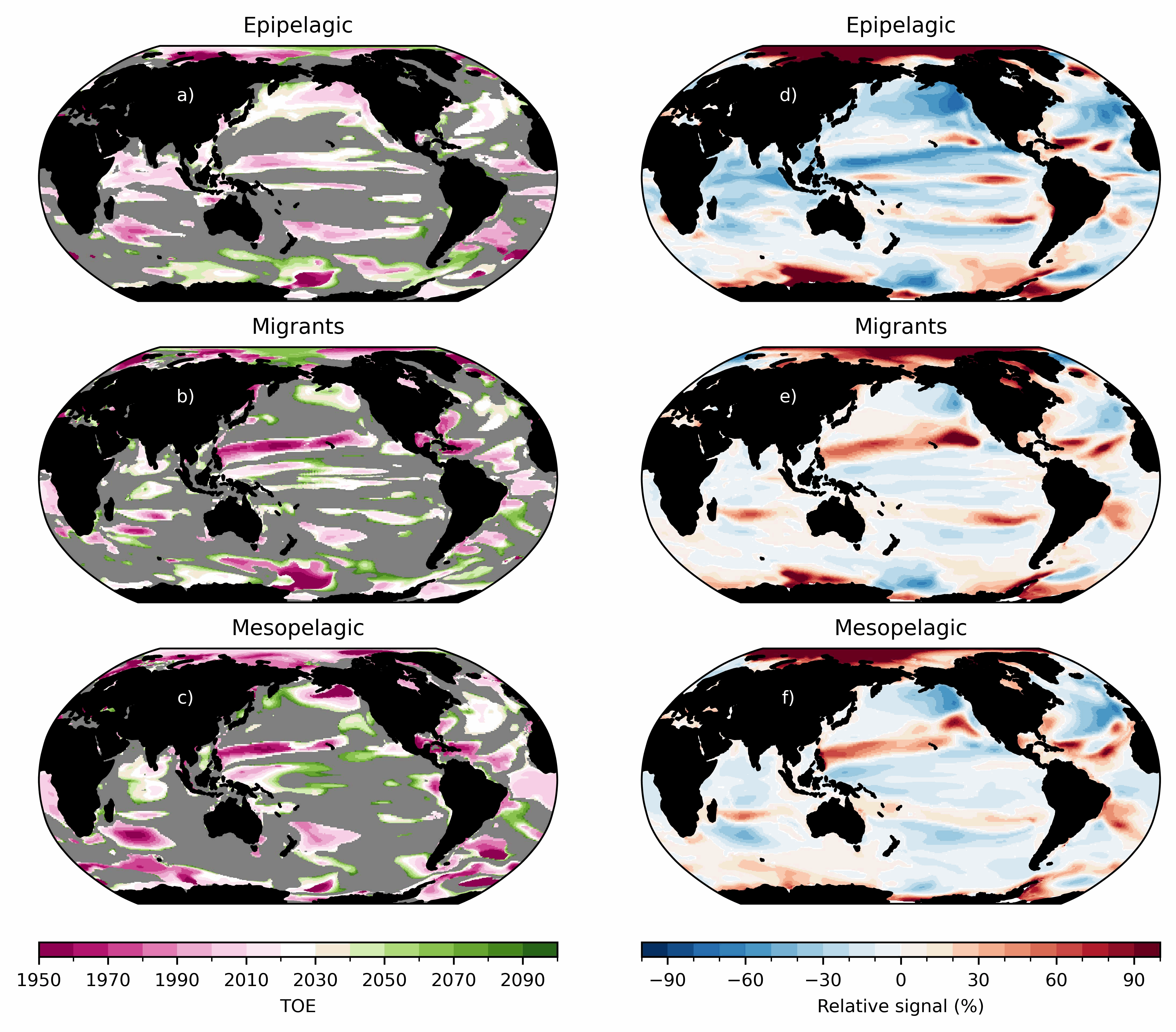
Ensemble simulations of the ecosystem model Apecosm (https://apecosm.org) forced by the IPSL-CM6-LR climate model with the climate change scenario SSP5-8.5. The output files contain yearly mean biomass density for 3 communities (epipelagic, mesopelagic migratory and mesopelagic redidents) and 100 size classes (ranging from 0.12cm to 1.96m) The model grid file is also provided. Units are in J/m2 and can be converted in kg/m2 by dividing by 4e6. These outputs are associated with the "Assessing the time of emergence of marine ecosystems from global to local scales using IPSL-CM6A-LR/APECOSM climate-to-fish ensemble simulations" paper from the Earth's Future "Past and Future of Marine Ecosystems" Special Collection.
-
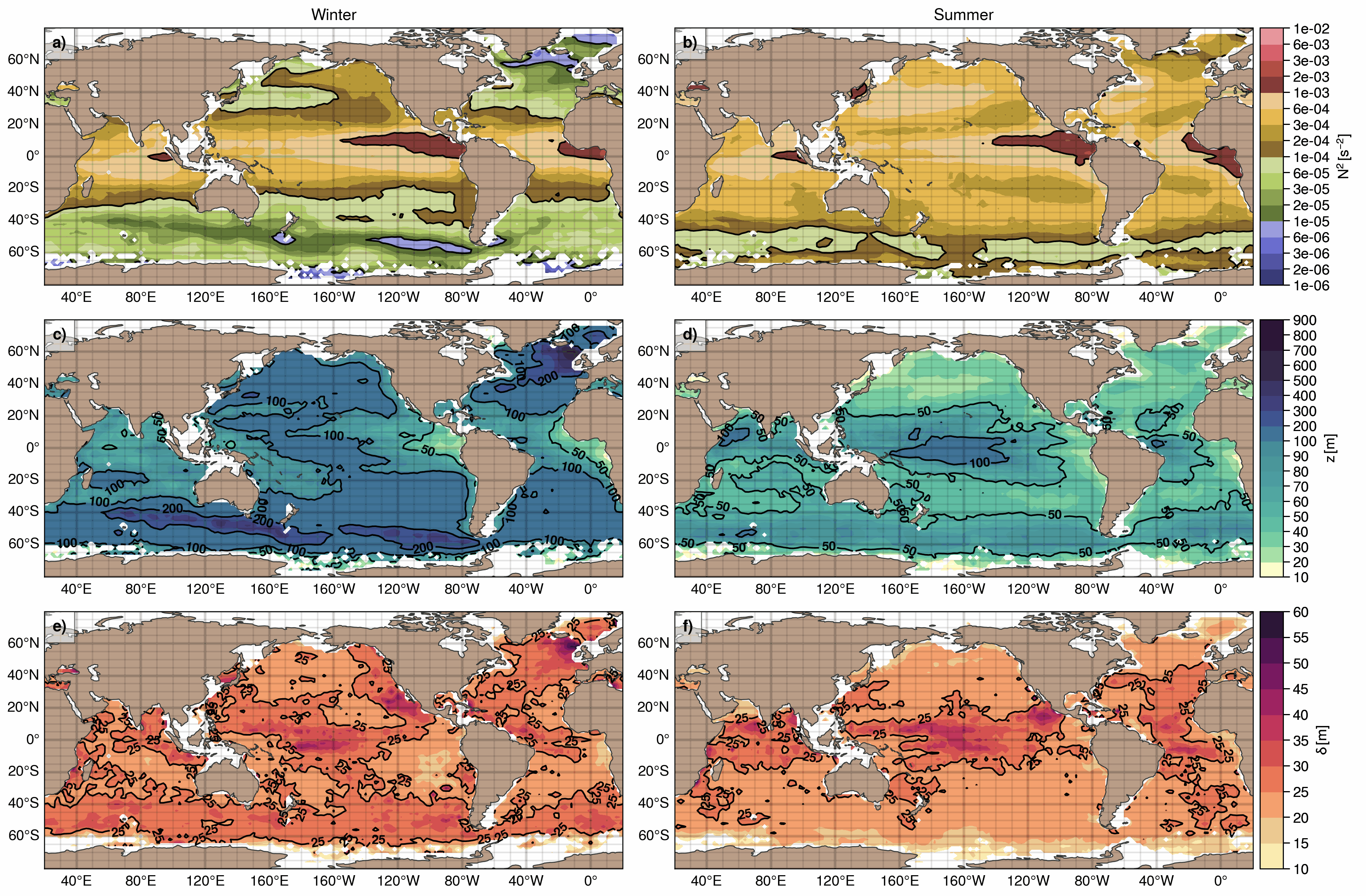
The upper ocean pycnocline (UOP) monthly climatology is based on the ISAS20 ARGO dataset containing Argo and Deep-Argo temperature and salinity profiles on the period 2002-2020. Regardless of the season, the UOP is defined as the shallowest significant stratification peak captured by the method described in Sérazin et al. (2022), whose detection threshold is proportional to the standard deviation of the stratification profile. The three main characteristics of the UOP are provided -- intensity, depth and thickness -- along with hydrographic variables at the upper and lower edges of the pycnocline, the Turner angle and density ratio at the depth of the UOP. A stratification index (SI) that evaluates the amount of buoyancy required to destratify the upper ocean down to a certain depth, is also included. When evaluated at the bottom of the UOP, this gives the upper ocean stratification index (UOSI) as discussed in Sérazin et al. (2022). Three mixed layer depth variables are also included in this dataset, including the one using the classic density threshold of 0.03 kg.m-3, along with the minimum of these MLD variables. Several statistics of the UOP characteristics and the associated quantities are available in 2°×2° bins for each month of the year, whose results were smoothed using a diffusive gaussian filter with a 500 km scale. UOP characteristics are also available for each profile, with all the profiles sorted in one file per month.
-
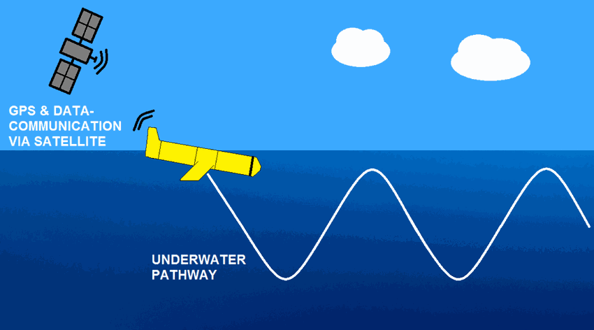
The observations of campe glider on imedia deployment (Mediterranean Sea - Western basin) are distributed in 4 files: - EGO NetCDF time-series (data, metadata, derived sea water current) - NetCDF profiles extracted from the above time-series - Raw data - JSON metadata used by the decoder The following parameters are provided : - Practical salinity - Sea temperature in-situ ITS-90 scale - Electrical conductivity - Sea water pressure, equals 0 at sea-level
-
This product contains observations and gridded files from two up-to-date carbon and biogeochemistry community data products: Surface Ocean Carbon ATlas SOCATv2023 and GLobal Ocean Data Analysis Project GLODAPv2.2023. The SOCATv2023-OBS dataset contains >25 million observations of fugacity of CO2 of the surface global ocean from 1957 to early 2023. The quality control procedures are described in Bakker et al. (2016). These observations form the basis of the gridded products included in SOCATv2023-GRIDDED: monthly, yearly and decadal averages of fCO2 over a 1x1 degree grid over the global ocean, and a 0.25x0.25 degree, monthly average for the coastal ocean. GLODAPv2.2023-OBS contains >1 million observations from individual seawater samples of temperature, salinity, oxygen, nutrients, dissolved inorganic carbon, total alkalinity and pH from 1972 to 2021. These data were subjected to an extensive quality control and bias correction described in Olsen et al. (2020). GLODAPv2-GRIDDED contains global climatologies for temperature, salinity, oxygen, nitrate, phosphate, silicate, dissolved inorganic carbon, total alkalinity and pH over a 1x1 degree horizontal grid and 33 standard depths using the observations from the previous major iteration of GLODAP, GLODAPv2. SOCAT and GLODAP are based on community, largely volunteer efforts, and the data providers will appreciate that those who use the data cite the corresponding articles (see References below) in order to support future sustainability of the data products.
-
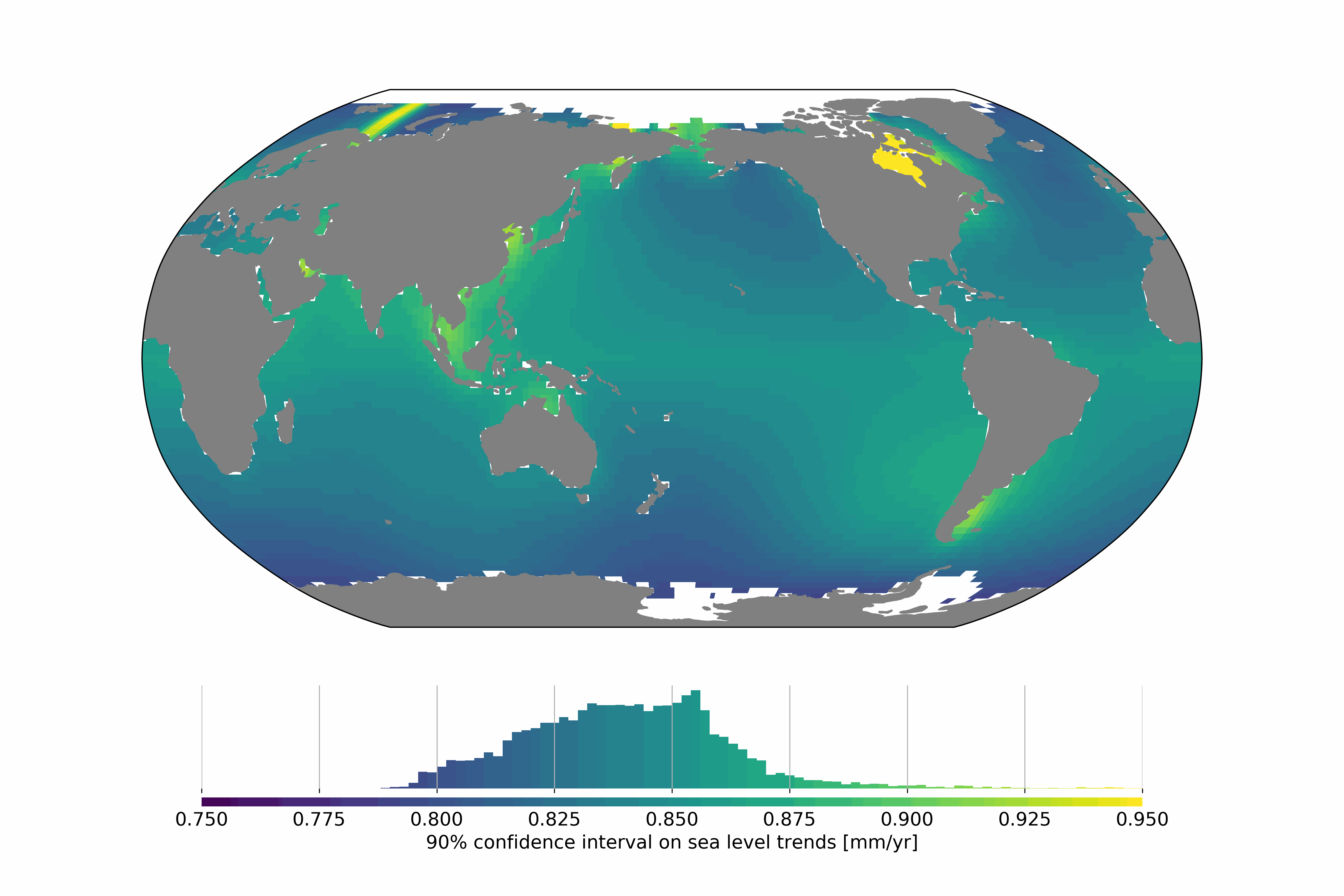
Satellite altimetry missions provide a quasi-global synoptic view of sea level over more than 25 years. The satellite altimetry constellation is used to build sea level maps and regional sea level indicators such as trends and accelerations. Estimating realistic uncertainties on these quantities is crucial to address some current climate science questions such as climate change detection and attribution or regional sea level budget closure for example. Previous studies have estimated the uncertainty for the global mean sea level (GMSL), but no uncertainty information is available at regional scales. In this study we estimate a regional satellite altimetry error budget and use it to derive maps of confidence intervals for local sea rise rates and accelerations. We analyze 27 years of satellite altimetry maps and derive the satellite altimetry error variance-covariance matrix at each grid point, prior to the estimation of confidence intervals on local trends and accelerations at the 90% confidence level using extended least squares estimators. Over 1993–2019, we find that the average local sea level trend uncertainty is 0.83 mm.yr-1 with local values ranging from 0.78 to 1.22 mm.yr-1. For accelerations, uncertainties range from 0.057 to 0.12 mm.yr-2, with a mean value of 0.063 mm.yr-2. Change history: - 2020/07/08: initial dataset submission over 1993-2018 - 2020/10/21: 1993-2019 update and addition of error levels
-
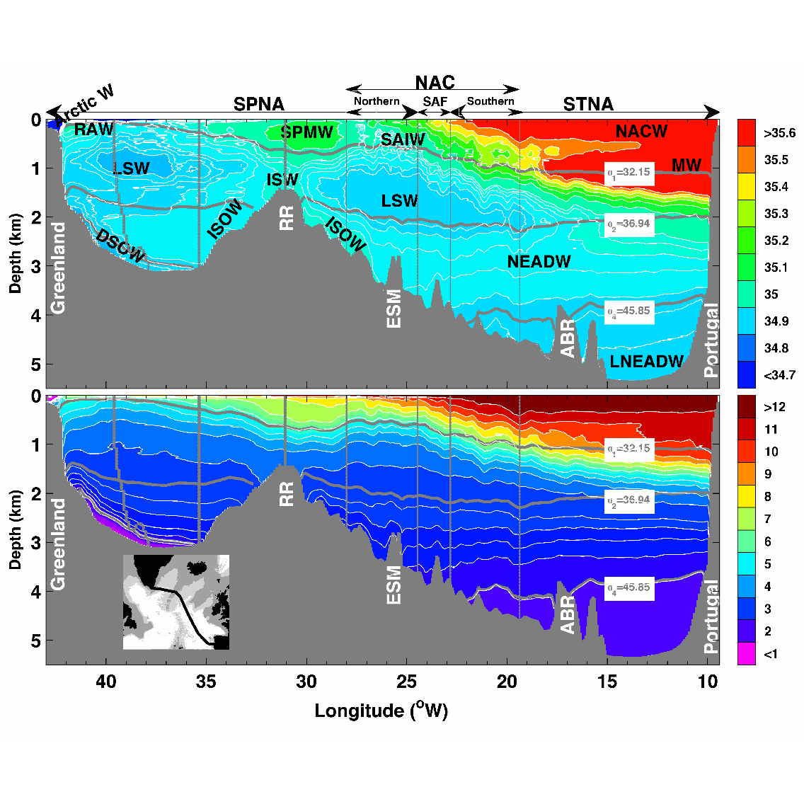
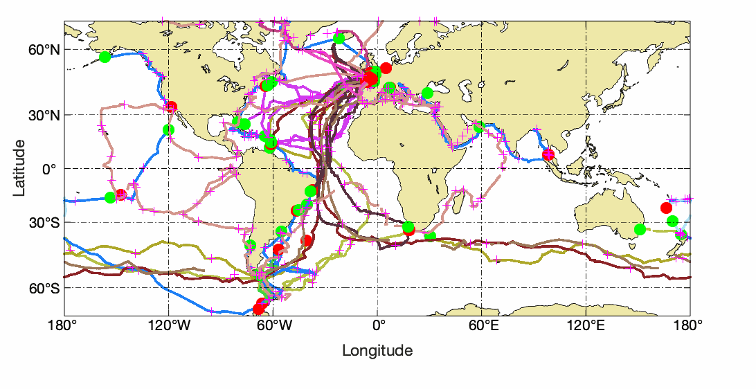
This data set contains the gridded hydrographic and transport data for the biennial Go-Ship A25 Greenland–Portugal OVIDE section from 2002 to 2012. The properties and transports are mapped on a 7km x 1m grid. Using a common grid facilitates the comparison between the different occupations of the line and the averaging. This data set was used in Daniault et al. (2016, Progress in Oceanography) to which the reader is referred for a description of the gridding method.
-
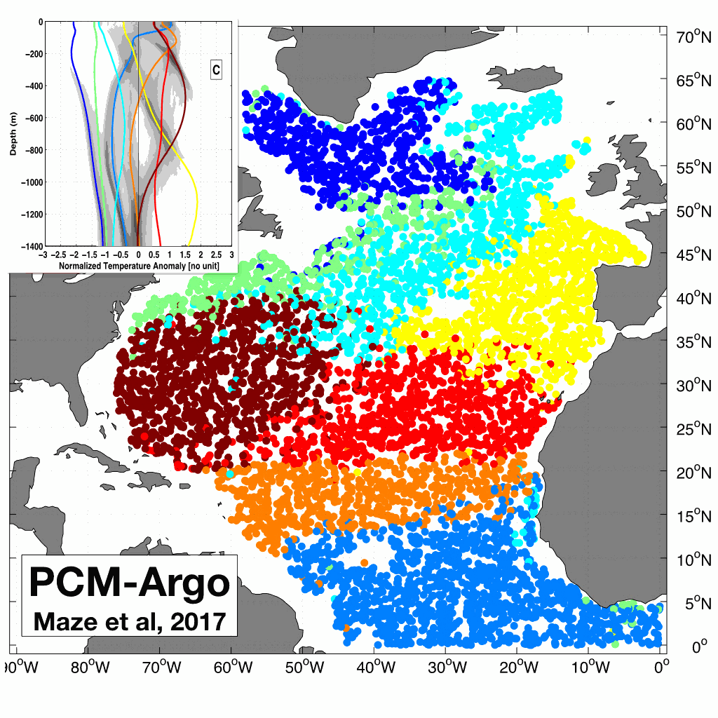
A quantitative understanding of the integrated ocean heat content depends on our ability to determine how heat is distributed in the ocean and what are the associated coherent patterns. This dataset contains the results of the Maze et al., 2017 (Prog. Oce.) study demonstrating how this can be achieved using unsupervised classification of Argo temperature profiles. The dataset contains: - A netcdf file with classification~results (labels and probabilities) and coordinates (lat/lon/time) of 100,684 Argo temperature profiles in North Atlantic. - A netcdf file with a Profile Classification Model (PCM) that can be used to classify new temperature profiles from observations or numerical models. The classification method used is a Gaussian Mixture Model that decomposes the Probability Density Function of the dataset into a weighted sum of Gaussian modes. North Atlantic Argo temperature profiles between 0 and 1400m depth were interpolated onto a regular 5m grid, then compressed using Principal Component Analysis and finally classified using a Gaussian Mixture Model. To use the netcdf PCM file to classify new data, you can checkout our PCM Matlab and Python toolbox here: https://github.com/obidam/pcm
-
This product integrates sea level observations aggregated and validated from the Regional EuroGOOS consortium (Arctic-ROOS, BOOS, NOOS, IBI-ROOS, MONGOOS) and Black Sea GOOS as well as from the Global telecommunication system (GTS) used by the Met Offices. The latest version of Copernicus delayed-mode Sea level product is also distributed from Copernicus Marine catalogue.