 Catalogue PIGMA
/Ocean Optics/Reflectance
Type of resources
Available actions
Topics
Keywords
Contact for the resource
Provided by
Years
Formats
Representation types
status
Resolution
-

Composite maps of sargassum detection index NFAI (Normalized Floating Algae Index). Daily gridded products provided in delayed time from February 2022 to a month before current date, made available as part of SeSaM SCO project (https://www.spaceclimateobservatory.org/sesam). Each map represents the sargassum presence (through normalized floatting alguae index) of the last 7 days at 0.01° resolution.
-

Composite maps of sargassum detection index NFAI (Normalized Floating Algae Index). Daily gridded products provided in delayed time from December 2020 to a month before current date, made available as part of SeSaM SCO project (https://www.spaceclimateobservatory.org/sesam) . Each map represents the sargassum presence (through normalized floatting alguae index) at 0.0025° (high) or 0.01° (low) resolutions.
-
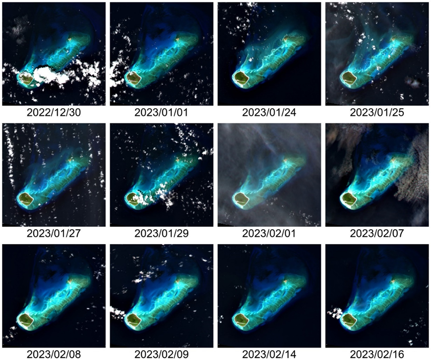
This Level 2 product provides marine reflectances from the VENµS mission, processed with the Polymer algorithm, on a subset of sites with coastal or inland areas. VENµS (Vegetation and Environment monitoring on a New Micro-Satellite) is a Franco-Israeli satellite launched in 2017, dedicated to the fine and regular monitoring of terrestrial vegetation, in particular cultivated areas, forests, protected natural areas, etc. The images acquired in 12 spectral bands by a camera provided by CNES, on a selection of about one hundred scientific sites spread over the planet, are of high spatial (5 m) and temporal resolution. The lifetime of the VENµS satellite has been divided into two phases: a first phase VM1 at an altitude of 720 km with a 2-day revisit, a native spatial resolution of 5.3 m and a swath of 27.6 km from August 2017 to November 2020, and a second phase VM5 at an altitude of 560 km with a daily revisit, a native spatial resolution of 4.1 m and a swath of 21.3 km from March 2022 to July 2024. VENµS is the first sensor on board an orbiting satellite to combine such revisit frequency and spatial finesse for vegetation monitoring. A subset of sites with coastal areas or inland waters have been identified to generate Level 2 data dedicated to marine reflectance. The geographical areas covered are given through a kmz file, see below to download it. This Level 2 data product has been processed using the Polymer algorithm developed by Hygeos (https://hygeos.com/en/polymer/) and provides marine reflectances for the VENµS bands from 420 to 865 nm. These reflectances, without units, include a bidirectional normalization for the Sun at nadir and the observer at nadir. VENµS data products (Level-1, Level-2 and Level-3) are primarily generated with the MAJA algorithm, further information can be found on THEIA website: https://www.theia-land.fr/en/product/venus/
-

Daily gridded Sargassum area coverage derived from MODIS Terra and Aqua observations over the Atlantic, produced with the AFAI (Alternative Floating Algae Index)-based SAREDA (SArgassum Evolving Distribution in the Atlantic) algorithm. The SAREDA (SArgassum Evolving Distribution in the Atlantic) algorithm performs a contextual detection of Sargassum using the Alternative Floating Algae Index (AFAI) (Wang and Hu, 2016). The AFAI deviation with respect to the local background is used to retrieve the Sargassum area coverage, i.e. the fraction of MODIS pixels covered with Sargassum. Daily gridded 1km and 5km composites are derived from MODIS-Terra and MODIS-Aqua instantaneous retrievals. Within the framework of the SAREDA project, supported by TOSCA-CNES and IRD, the MIO has partnered with the AERIS cluster and its ICARE data and services centre specialised in the massive exploitation of Earth observation spatial data, for the processing of data. GeoID-OCEAN contributed to the implementation of the prototype processing chain.
-

The ODATIS Ocean Color MR product provides optical reflectance measurements as well as related physical, subsurface and biogeochemical parameters at 300 m spatial resolution along the entire French metropolitan coastal zone, according to the criteria defined by the ODATIS Scientific Expert Consortium (CES) dedicated to ocean color : https://www.odatis-ocean.fr/activites/consortium-dexpertise-scientifique/ces-couleur-de-locean. Product processing is performed from Level 1 to Level 3, and is reprojected on a regular square grid format. Data are temporally aggregated and provided as daily, 8 day and monthly products. The "Basic" version of the ODATIS MR product includes data from the MODIS sensor processed with the "NIR/SWIR" atmospheric correction method (Wang and Shi, 2007), as well as data from the MERIS and OLCI-A/B sensors processed with the Polymer atmospheric correction (Hygeos, https://www.hygeos.com/polymer). List of available parameters for each sensor: • MODIS : NRRS555, CHL-OC5, SPM-G, CDOM, T-FNU, SST-NIGHT • OLCI-A/B / MERIS : NRRS560, CHL-OC5, SPM-G, CDOM, T-FNU