 Catalogue PIGMA
Less than 4 days
Type of resources
Topics
Keywords
Contact for the resource
Provided by
Years
Formats
Representation types
status
Resolution
-
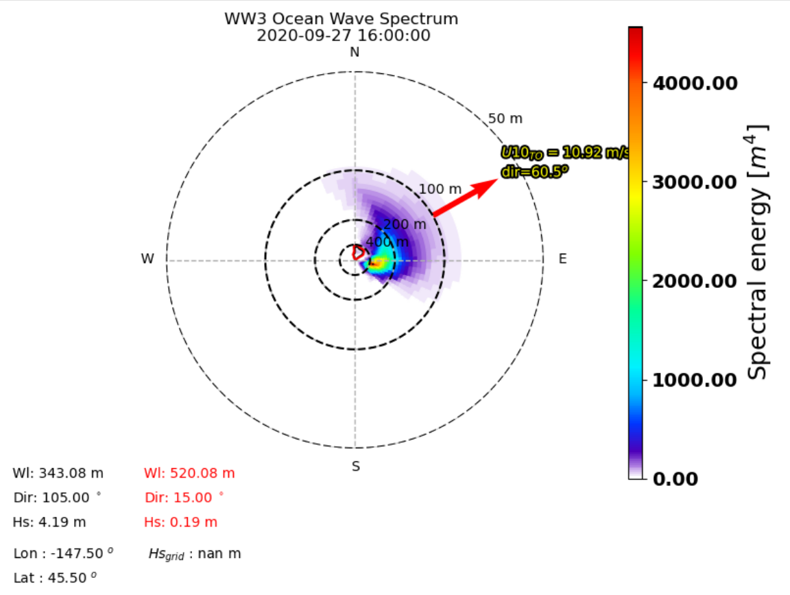
The Ifremer Wind and Wave Operation Center (IWWOC) runs daily the WaveWatch III (WW3) model to provide surface wave colocations with both SCAT and SWIM instruments onboard CFOSAT. CFOSAT (Chinese French Ocean SATellite) is a french-chinese mission launched in 2018, whose aim is to provide wind (SCAT instrument) and wave (SWIM instrument) measurements over the sea surface. Directional wave spectra are calculated over SWIM sensing geometries over each measurement, thanks to the dedicated toolbox (WAVERUN) which was developed by IFREMER for the colocation of WW3 and satellite remote sensing products. The current Ifremer WW3 run is global, hourly and at 0.25° spatial resolution. Two different colocation product are generated: - WW3 with CWWIC L2 provides WW3 directional spectra over the CWWIC SWIM L2 geometry, meaning a colocated valid is provided for each box defined in CWWIC L2 product. - WW3 with IWWOC L2S provides a WW3 directional spectra over IWWOC SWI_L2S__ product. For each of these products, a colocation product is provided respetively for each input file from CWWIC SWI_L2___ and IWWOC SWI_L2S (for each incidence in the later one). It contains the modelled spectral density and all forcing fields: current, wind, friction velocity, air sea temperature difference. Other parameters can be added in the future. The SWIM and WW3 colocation product is generated and distributed by Ifremer / CERSAT in the frame of the Ifremer Wind and Wave Operation Center (IWWOC) co-funded by Ifremer and CNES and dedicated to the processing of the delayed mode data of CFOSAT mission. Note: colocations with SCAT instrument onboard CFOSAT are also within the SWISCA L2S product also available at IWWOC. It provides WW3 directional spectra over SCAT L2A geometry, meaning a model value is calculated for each Wind Vector Cell (WVC) of L2A/L2B types of SCAT product.
-

The Level-2 Ka-band Radar Interferometer (KaRIn) low rate (LR, ocean) sea surface height (SSH) data product from the Surface Water and Ocean Topography (SWOT) mission, also referenced by the short name L2_LR_SSH, provides ocean topography measurements from the low rate ocean data stream of the KaRIn instrument, spanning 60 km on either side of the nadir altimeter with a nadir gap. The L2_LR_SSH product is available continuously and globally, although different versions of the product may be produced at different latencies and/or through different reprocessing with refined input data. Note that L2_LR_SSH does not include SSH data from the SWOT nadir altimeter. The SWOT L2_LR_SSH product is organized as a collection of four subproducts, the L2_LR_SSH ['Basic'] is described in this metadata sheet. The 3 other file types (['WindWave'], ['Expert'], ['Unsmoothed']) are described by 3 different metadata sheets that can be accessed through the links below. The ['Basic'] file on this metadata sheet, is intended for users who are interested in SSH measurements and who will use the KaRIn measurements as provided. The ['Basic'] L2_LR_SSH includes corrected sea surface height (SSH), sea surface height anomaly (SSHA), data quality flags, geophysical reference fields, and height correction information on a 2-km geographically fixed grid. The ['WindWave'] L2_LR_SSH is intended for users interested in wind and wave information. The ['Expert'] L2_LR_SSH is intended for expert users who are interested in the details of how the KaRIn measurements were derived and who may use detailed information for their own custom processing. The ['Unsmoothed'] L2_LR_SSH, also intended for expert users, is provided on a finer 'native' grid of 250-m (with minimal smoothing applied), and has a significantly larger data volume than the other files. May 2025: v3.0 (version D) Production and distribution of the L2_LR_SSH version D products: - PID0 for forward-processed version D products: from May 6, 2025 onward, - PGD0 for reprocessed version D products: from March 30 to July 10, 2023 (phase CalVal) and from July 26, 2023 to May 19, 2025 (phase Science) is ongoing. August 2024: v2.0 (version D) L2_LR_SSH version C products declared as validated by the SWOT project. March 2024: v2.0 (version C) Production and distribution of the pre-validated L2_LR_SSH version C products: - PIC0 for forward-processed version C products: November 23, 2023 to present, - PGC0 for reprocessed version C products: from March 30 to July 10, 2023 (phase CalVal) and from July 26, 2023 to January 25, 2024 (phase Science) November 2023: v1.0 The beta pre-validated L2_LR_SSH version 1.0 product (summer 2023 reprocessing release) is available only for the 1-day CalVal orbit phase, from March 29 to July 10, 2023, and the 21-day Science orbit phase from September 7 to November 21, 2023.
-

The Level-2 Ka-band Radar Interferometer (KaRIn) low rate (LR, ocean) sea surface height (SSH) data product from the Surface Water and Ocean Topography (SWOT) mission, also referenced by the short name L2_LR_SSH, provides ocean topography measurements from the low rate ocean data stream of the KaRIn instrument, spanning 60 km on either side of the nadir altimeter with a nadir gap. The L2_LR_SSH product is available continuously and globally, although different versions of the product may be produced at different latencies and/or through different reprocessing with refined input data. Note that L2_LR_SSH does not include SSH data from the SWOT nadir altimeter. The SWOT L2_LR_SSH product is organized in four files, the L2_LR_SSH ['WindWave'] is described in this metadata sheet. The 3 other file types (['Basic'], ['Expert'], ['Unsmoothed']) are described by 3 different metadata sheets that can be accessed via the links below. The ['WindWave'] file is intended for users interested in wind and wave information. The ['Basic'] file is intended for users who are interested in SSH measurements and who will use the KaRIn measurements as provided. The ['Expert'] file is intended for expert users who are interested in the details of how the KaRIn measurements were derived and who may use detailed information for their own custom processing. The ['Unsmoothed'] file, also intended for expert users, is provided on a finer 'native' grid of 250-m (with minimal smoothing applied), and has a significantly larger data volume than the other files. The ['WindWave'] L2_LR_SSH includes measured significant wave height (SWH), normalized radar cross section (NRCS or backscatter cross section or sigma0), wind speed derived from sigma0 and SWH, wind and wave model information, and quality flags on a 2 km geographically fixed grid. May 2025: v3.0 (version D) Production and distribution of the L2_LR_SSH version D products: - PID0 for forward-processed version D products: from May 6, 2025 onward, - PGD0 for reprocessed version D products: from March 30 to July 10, 2023 (phase CalVal) and from July 26, 2023 to May 19, 2025 (phase Science) is ongoing. August 2024: v2.0 (version D) L2_LR_SSH version C products declared as validated by the SWOT project. March 2024: v2.0 (version C) Production and distribution of the pre-validated L2_LR_SSH version C products: - PIC0 for forward-processed version C products: November 23, 2023 to present, - PGC0 for reprocessed version C products: from March 30 to July 10, 2023 (phase CalVal) and from July 26, 2023 to January 25, 2024 (phase Science) November 2023: v1.0 The beta pre-validated L2_LR_SSH version 1.0 product (summer 2023 reprocessing release) is available only for the 1-day CalVal orbit phase, from March 29 to July 10, 2023, and the 21-day Science orbit phase from September 7 to November 21, 2023.
-

The Level-2 Ka-band Radar Interferometer (KaRIn) low rate (LR, ocean) sea surface height (SSH) data product from the Surface Water and Ocean Topography (SWOT) mission, also referenced by the short name L2_LR_SSH, provides ocean topography measurements from the low rate ocean data stream of the KaRIn instrument, spanning 60 km on either side of the nadir altimeter with a nadir gap. The L2_LR_SSH product is available continuously and globally, although different versions of the product may be produced at different latencies and/or through different reprocessing with refined input data. Note that L2_LR_SSH does not include SSH data from the SWOT nadir altimeter. The SWOT L2_LR_SSH product is organized in four files, the L2_LR_SSH ['Expert'] is described in this metadata sheet. The 3 other file types (['Basic'], ['WindWave'], ['Unsmoothed']) are described by 3 different metadata sheets that can be accessed via the links below. The ['Expert'] file is intended for expert users who are interested in the details of how the KaRIn measurements were derived and who may use detailed information for their own custom processing. The ['Basic'] file is intended for users who are interested in SSH measurements and who will use the KaRIn measurements as provided. The ['WindWave'] file is intended for users interested in wind and wave information. The ['Unsmoothed'] file, also intended for expert users, is provided on a finer 'native' grid of 250-m (with minimal smoothing applied), and has a significantly larger data volume than the other files. The ['Expert'] L2_LR_SSH includes copies of all variables in the Basic and WindWave files (sea surface height (SSH), sea surface height anomaly (SSHA), data quality flags, geophysical reference fields, height correction information, significant wave height (SWH), normalized radar cross section (NRCS or backscatter cross section or sigma0), wind speed derived from sigma0 and SWH, wind and wave model information, quality flags on a 2 km geographically fixed grid), plus more detailed information on the KaRIn instrument and environmental corrections, radiometer data, and geophysical models on a 2 km geographically fixed grid. May 2025: v3.0 (version D) Production and distribution of the L2_LR_SSH version D products: - PID0 for forward-processed version D products: from May 6, 2025 onward, - PGD0 for reprocessed version D products: from March 30 to July 10, 2023 (phase CalVal) and from July 26, 2023 to May 19, 2025 (phase Science) is ongoing. August 2024: v2.0 (version D) L2_LR_SSH version C products declared as validated by the SWOT project. March 2024: v2.0 (version C) Production and distribution of the pre-validated L2_LR_SSH version C products: - PIC0 for forward-processed version C products: November 23, 2023 to present, - PGC0 for reprocessed version C products: from March 30 to July 10, 2023 (phase CalVal) and from July 26, 2023 to January 25, 2024 (phase Science) November 2023: v1.0 The beta pre-validated L2_LR_SSH version 1.0 product (summer 2023 reprocessing release) is available only for the 1-day CalVal orbit phase, from March 29 to July 10, 2023, and the 21-day Science orbit phase from September 7 to November 21, 2023.
-
The Level-2 Ka-band Radar Interferometer (KaRIn) low rate (LR, ocean) sea surface height (SSH) data product from the Surface Water and Ocean Topography (SWOT) mission, also referenced by the short name L2_LR_SSH, provides ocean topography measurements from the low rate ocean data stream of the KaRIn instrument, spanning 60 km on either side of the nadir altimeter with a nadir gap. The L2_LR_SSH product is available continuously and globally, although different versions of the product may be produced at different latencies and/or through different reprocessing with refined input data. Note that L2_LR_SSH does not include SSH data from the SWOT nadir altimeter. The SWOT L2_LR_SSH product is organized in four files, the L2_LR_SSH ['Unsmoothed'] is described in this metadata sheet. The 3 other file types (['Basic'], ['WindWave'], ['Expert']) are described by 3 different metadata sheets that can be accessed via the links below. The ['Unsmoothed'] file, also intended for expert users, is provided on a finer 'native' grid of 250-m (with minimal smoothing applied), and has a significantly larger data volume than the other files. The ['Basic'] file is intended for users who are interested in SSH measurements and who will use the KaRIn measurements as provided. The ['WindWave'] file is intended for users interested in wind and wave information. The ['Expert'] file is intended for expert users who are interested in the details of how the KaRIn measurements were derived and who may use detailed information for their own custom processing. The ['Unsmoothed'] L2_LR_SSH includes sea surface height (SSH) and sigma0 without additional smoothing relative to the native KaRIn downlink resolution on a ~250 m native (center-beam) grid. The Unsmoothed file contains two groups, left and right, each of which contains the data for half (one side from nadir) of the KaRIn swath. May 2025: v3.0 (version D) Production and distribution of the L2_LR_SSH version D products: - PID0 for forward-processed version D products: from May 6, 2025 onward, - PGD0 for reprocessed version D products: from March 30 to July 10, 2023 (phase CalVal) and from July 26, 2023 to May 19, 2025 (phase Science) is ongoing. August 2024: v2.0 (version D) L2_LR_SSH version C products declared as validated by the SWOT project. March 2024: v2.0 (version C) Production and distribution of the pre-validated L2_LR_SSH version C products: - PIC0 for forward-processed version C products: November 23, 2023 to present, - PGC0 for reprocessed version C products: from March 30 to July 10, 2023 (phase CalVal) and from July 26, 2023 to January 25, 2024 (phase Science) November 2023: v1.0 The beta pre-validated L2_LR_SSH version 1.0 product (summer 2023 reprocessing release) is available only for the 1-day CalVal orbit phase, from March 29 to July 10, 2023, and the 21-day Science orbit phase from September 7 to November 21, 2023.
-

The main objective of the SWIM Level 2S (L2S) product is to provide along-track directional wave spectra measures, as well as the integrated parameters of the associated wave systems (wave length, significant wave height, direction), over the global ocean, as observed with SWIM instrument onboard CFOSAT. CFOSAT (Chinese French Ocean SATellite) is a french-chinese mission launched in 2018, whose aim is to provide wind (SCAT instrument) and wave (SWIM instrument) measurements over the sea surface. The wave spectra and their associated partitions are provided independently for each SWIM incidence (from 2° to 10°), together with the sigma0 resampled at a 20m resolution. They are complemented with information from the nadir beam such as the sigma0, wind speed, significant wave height or rain flag. The SWIM level 2S (L2S) product is generated in delayed mode, a few days after acquisition. It complements the Near-Real Time (NRT) L2 product delivered by the CWWIC center by providing an alternative and evolutive processing to test and implement quickly new algorithms for the wave inversion over the whole mission archive. These evolutions may take advantage of better ancillary data not available in NRT (ice mask product, best estimates of wind or wave model), of the combination with wind measurements from the onboard SCAT scatterometer. The product is also designed to handle complex situations such as coastal areas and heterogeneous seas. These complex situations are by nature of particular scientific interest (e.g. wind wave interactions, wave evolution in coastal region). This version 2 improves the previous release in particular through a new empirical modulation transfer function (MTF) and better partitioning. The dataset is also lighter in size. It has been completely reprocessed from SWIM Level 1 archive. Note that the dataset is split on the access server in two different sub-versions (**2.0** for the L2S using Level 1 in OP06 version, **2.1** for the L2S using Level 1 in OP07 version). No major differences are expected. The SWIM L2S product is generated and distributed by Ifremer / CERSAT in the frame of the Ifremer Wind and Wave Operation Center (IWWOC) co-funded by Ifremer and CNES and dedicated to the processing of the delayed mode data of CFOSAT mission.
-
The SWISCA Level 2S (L2S) product provides along-track colocation of SWIM wave measuring instrument onto SCAT scatterometer grid, over the global ocean. SWIM and SCAT are both instruments onboard CFOSAT. CFOSAT (Chinese French Ocean SATellite) is a french-chinese mission launched in 2018, whose aim is to provide wind (SCAT instrument) and wave (SWIM instrument) measurements over the sea surface. The SWISCA L2S product is broken down into three different subproducts: - L2A containing the sigma0 of both SWIM and SCAT - L2B containing the wave parameters measured by SWIM and wind vectors measured by SCAT - AUX containing additional ancillary fields such as sea ice concentration (from CERSAT/SSMI), ocean currents (from CMEMS/GlobCurrent), SST and Wind (from ECMWF), rain rate (from IMERG), and WaveWatch3 wave spectra. All SWIM and ancillary observations are resampled onto SCAT scatterometer's geometry (wind vector cells, WVC). The SWISCA level 2S product is generated in delayed mode, a few days after acquisition. It is intended to foster cross analysis of SWIM and SCAT observations, and their combination to improve the retrieval of both wind and wave parameters. The SWISCA L2S product is generated and distributed by Ifremer / CERSAT in the frame of the Ifremer Wind and Wave Operation Center (IWWOC) co-funded by Ifremer and CNES and dedicated to the processing of the delayed mode data of CFOSAT mission.