 Catalogue PIGMA
CDS-SAT-AVISO
Type of resources
Available actions
Topics
Provided by
Years
Formats
Representation types
Resolution
-
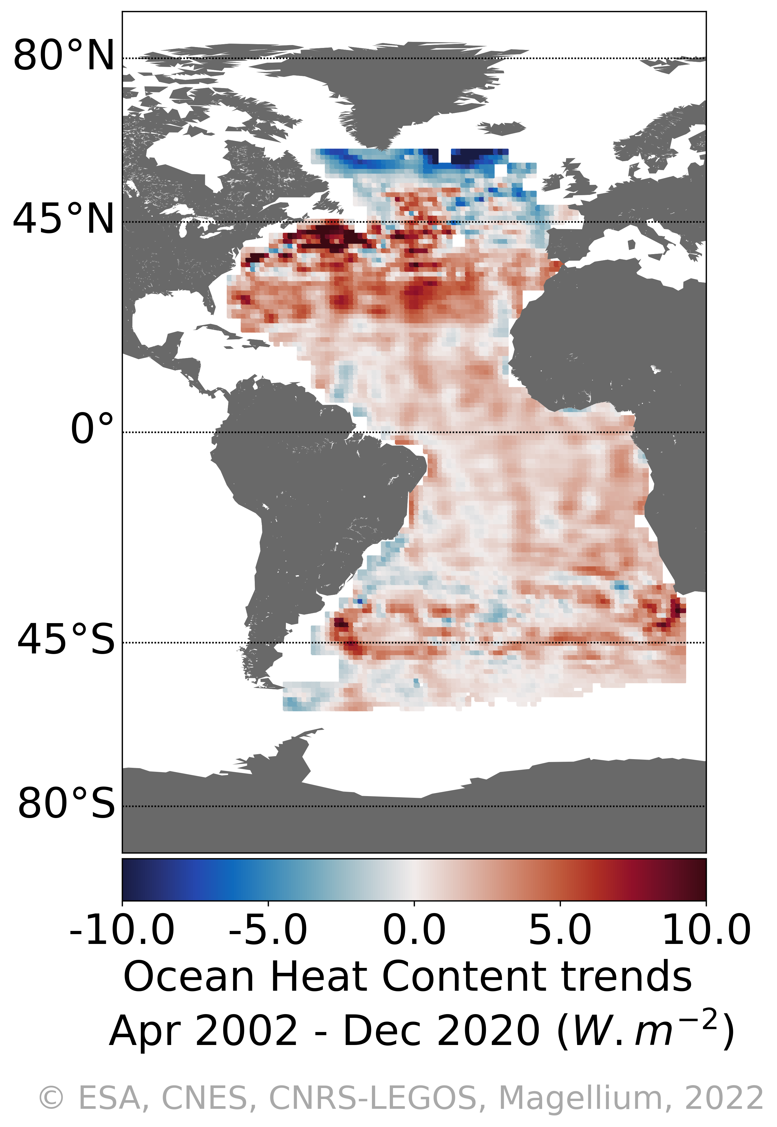
Variations régionales du contenu en chaleur de l'océan Atlantique avec l'approche géodésique spatiale : "4DAtlantic-OHC" Le "Contenu en chaleur de l'océan" (ou OHC pour "Ocean Heat Content") est estimé à partir de la mesure de la dilatation thermique de l'océan basée sur les différences entre le contenu total du niveau de la mer dérivé des mesures altimétriques et le contenu massique dérivé des données gravimétriques, noté «altimétrie-gravimétrie». Sont disponibles : - les grilles mensuelles des variations de l'OHC sur l'Atlantique (1°x1°) - les tendances de l'OHC et incertitudes.
-
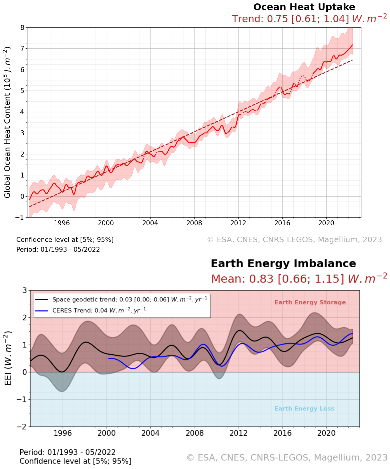
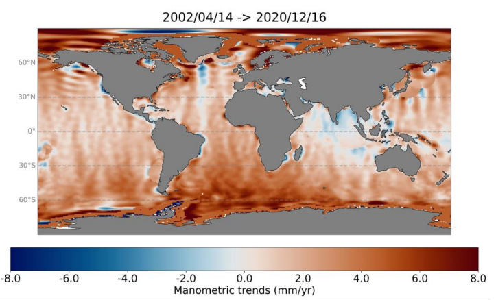
Le "Contenu en chaleur de l'océan" (ou OHC pour "Ocean Heat Content") est estimé à partir de la mesure de la dilatation thermique de l'océan basée sur les différences entre le contenu total du niveau de la mer dérivé des mesures altimétriques et le contenu massique dérivé des données gravimétriques, noté «altimétrie-gravimétrie». L'indicateur "Déséquilibre énergétique de la Terre" (ou EEI pour "Earth Energy Imbalance") est obtenu à partir des variations temporelles du contenu en chaleur de l'océan (OHC), c'est-à-dire en calculant sa dérivée (appelée absorption de chaleur océanique). Le jeu de données est livré en deux fichiers distincts. Le principal contient les variables essentielles comme les séries temporelles du contenu thermique global des océans, du déséquilibre énergétique de la Terre et leurs matrices de variance-covariance relatives. Le second fichier contient plus de variables que le 1er fichier, comme les séries temporelles des grilles de changement Ocean Mass, Sea Level et Steric Sea Level. Il inclut également des variables supplémentaires qui n'ont pas été utilisées pour le calcul du Global ocean heat content, comme les séries temporelles Global mean of ocean mass, Global mean sea level et Global mean steric sea level, mais qui peuvent néanmoins présenter un intérêt pour les utilisateurs. Les utilisateurs trouveront donc notamment: - la carte régionale des tendances pour l'indicateur OHC (cf image associée à cette fiche de métadonnée), - la série temporelle de l 'OHC global des océans (représentative du globe en fonction de la disponibilité des données d'entrée), - la série temporelle de l'EEI (issu de l'OHC global filtré à partir de signaux inférieurs à 3 ans), - les incertitudes associées à ces deux jeux de données.
-

Tourbillons détectés en temps différé (Delayed-Time - DT) pour toute la période [1993 - aujourd'hui]. Les variables fournies incluent pour chaque fichier journalier, et pour un type de rotation (Cyclonique/Anticyclonique) : - Position du centre (Longitude et latitude du centre du cercle le mieux ajusté avec le contour de la vitesse géostrophique moyenne circonférentielle maximale) ; - Amplitude (|SSH(local_extremum) - SSH(outermost_contour)|) ; - Rayon de vitesse (Rayon du cercle de meilleur ajustement avec le contour de la vitesse géostrophique moyenne circonférentielle maximale) ; - Vitesse moyenne (Vitesse géostrophique moyenne du contour définissant le rayon de vitesse) ; - Profil de vitesse (profil des valeurs moyennes de vitesse du contour effectif vers l'intérieur jusqu'au plus petit contour intérieur) ; - Contour effectif (Plus grand contour du tourbillon détecté) ; - Contour de vitesse (Contour de la vitesse géostrophique moyenne circonférentielle maximale pour le tourbillon détecté).
-
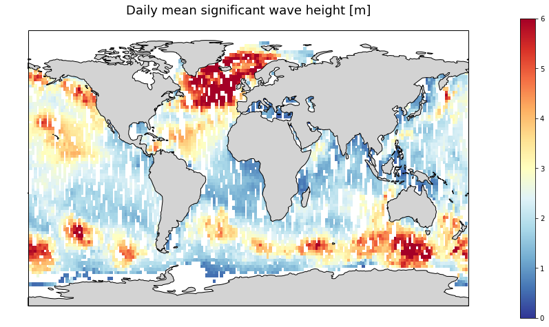
Produits altimétriques multi-missions combinées en temps quasi-réel de hauteurs significatives des vagues. Ce jeu de données combine les données SWH (Significant Wave Height) le long de la trace des missions suivantes : Jason-3, Sentinel-3A, Sentinel-3B, SARAL/AltiKa, Cryosat-2 et CFOSAT. Seules les données valides sont incluses dans ce produit grillé dune résolution horizontale de 2° et est produit quotidiennement.
-
GDR L2 from ESA Baseline-C converted by CTOH into netCDF, splited by ascending/descending pass and augmented of recent corrections
-
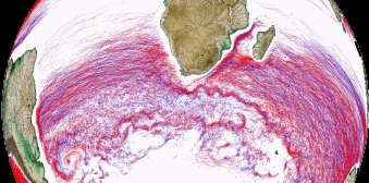
Tourbillons détectés en temps réel (Near Real-Time - NRT) sur la période 01/01/2018 - à ce jour (avec 15 jours de délai). Les variables fournies incluent pour chaque fichier journalier, et pour un type de rotation (Cyclonique/Anticyclonique) : - Position du centre (Longitude et latitude du centre du cercle le mieux ajusté avec le contour de la vitesse géostrophique moyenne circonférentielle maximale) ; - Amplitude (|SSH(local_extremum) - SSH(outermost_contour)|) ; - Rayon de vitesse (Rayon du cercle de meilleur ajustement avec le contour de la vitesse géostrophique moyenne circonférentielle maximale) ; - Vitesse moyenne (Vitesse géostrophique moyenne du contour définissant le rayon de vitesse) ; - Profil de vitesse (profil des valeurs moyennes de vitesse du contour effectif vers l'intérieur jusqu'au plus petit contour intérieur) ; - Contour effectif (Plus grand contour du tourbillon détecté) ; - Contour de vitesse (Contour de la vitesse géostrophique moyenne circonférentielle maximale pour le tourbillon détecté).
-
Tourbillons détectés en temps différé (Delayed-Time - DT) pour toute la période [1993 - aujourd'hui]. Les variables fournies incluent pour chaque fichier journalier, et pour un type de rotation (Cyclonique/Anticyclonique) : - Position du centre (Longitude et latitude du centre du cercle le mieux ajusté avec le contour de la vitesse géostrophique moyenne circonférentielle maximale) ; - Amplitude (|SSH(local_extremum) - SSH(outermost_contour)|) ; - Rayon de vitesse (Rayon du cercle de meilleur ajustement avec le contour de la vitesse géostrophique moyenne circonférentielle maximale) ; - Vitesse moyenne (Vitesse géostrophique moyenne du contour définissant le rayon de vitesse) ; - Profil de vitesse (profil des valeurs moyennes de vitesse du contour effectif vers l'intérieur jusqu'au plus petit contour intérieur) ; - Contour effectif (Plus grand contour du tourbillon détecté) ; - Contour de vitesse (Contour de la vitesse géostrophique moyenne circonférentielle maximale pour le tourbillon détecté).
-

Produit de hauteurs de mer simulées SWOT issues des 2 altimètres : l'altimètre interférométrique KaRIn et l'altimètre Nadir. Ce produit contient des données de niveau 2 (L2) Low Rate (LR) (L2_LR_SSH) conçues pour les surfaces océaniques et des données de niveaux 2 et 3 de la hauteur de surface (SSH) corrigée par les estimations des erreurs simulées.
-
Les variations barystatiques et manométriques du niveau marin représentent la composante de masse des variations du niveau marin aux échelles globale et régionale respectivement. Les variations barystatiques et manométriques du niveau marin sont estimées ici à partir de la gravimétrie, issues des mesures des missions de gravimétrie spatiale GRACE et GRACE - Follow On. Deux produits sont distribués sur la période avril 2002 à août 2022 : - Les variations barystatiques du niveau de la mer à partir de la gravimétrie : séries temporelles mensuelles, - Les variations manométriques du niveau de la mer à partir de la gravimétrie : grilles mensuelles 1x1°.
-

Les variations barystatiques et manométriques du niveau marin représentent la composante de masse des variations du niveau marin aux échelles globale et régionale respectivement. Les variations barystatiques et manométriques du niveau marin sont estimées ici à partir du bilan du niveau marin. Le calcul du bilan du niveau marin combinent les mesures d’altimétrie radar satellitaires à celles de capteurs in situ. Cette approche par résolution du bilan marin est basée sur l’étude de Barnoud et al., (2023). Deux produits sont distribués sur la période de janvier 1993 à décembre 2020: - Les variations barystatiques du niveau de la mer à partir du bilan marin : séries chronologiques mensuelles, - Les variations manométriques du niveau de la mer par rapport au bilan marin: grilles mensuelles de 1°x1°