 Catalogue PIGMA
1992
Type of resources
Available actions
Topics
Keywords
Contact for the resource
Provided by
Years
Formats
Representation types
Update frequencies
status
Scale
-
Colloque organise par le Conseil scientifique et culturel du PNR des Landes de Gascogne
-
Produits altimétriques auxiliaires
-
En complément des suivis Rebent, l’IUEM-OSU a mis en place depuis 1992 un suivi de la macrofaune benthique dans des habitats particuliers : herbier à Zostera marina et maërl, sur plusieurs sites, deux fois par an.
-
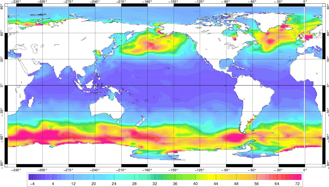
Produits altimétriques auxiliaires - élévations de marées, courants de marées, effets de charge dues à la marée
-
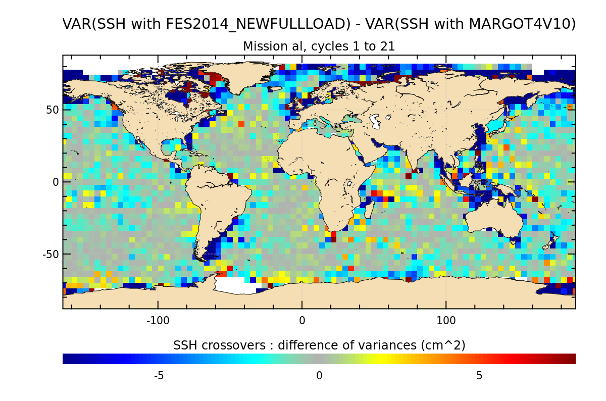
La correction atmosphérique dynamique (DAC) permet de prendre en compte la réponse dynamique de l'océan au forçage atmosphérique pour les hautes fréquences. Contenu: Produits altimétriques auxiliaires contenant des fichiers grillés sur une grille régulière de 0.25°x0.25°; 4 fichiers sont disponibles par jour (00:00, 6:00, 12:00, 18:00 GMT), placés dans des répertoires annuels (1992 - année en cours) Utilisation: océanographie côtière, océanographie opérationnelle, circulation océanique, marées Description: correction atmosphérique dynamique calculée à partir : - du modèle barotrope Mog2D-G Haute Résolution développé par le Legos/CNRS, pour les hautes fréquences (i.e moins de 20 jours) - d'une correction de baromètre inverse développée par CLS supposant une réponse statique de l'océan au forçage atmosphérique, et négligeant les effets du vent pour les basses fréquences (i.e. plus de 20 jours) Couverture géographique: globale Principales améliorations de la nouvelle version V4.0 (août 2023) : - Utilisation d'une nouvelle base de données bathymétriques, provenant de la solution globale de marée FES2014. - Mise à jour de la version du modèle barotrope, pour s'adapter au modèle TUGO (Pineau-Guillou 2018) : inclure des mises à jour des paramètres internes de dissipation de la traînée des vagues et de certains autres paramètres internes. - L'interpolation des variables de pression et de vent du ECMWF a été améliorée. - La bibliothèque du ECMWF a été mise à jour de grib_api 1.23 à ecCodes 2.20. - La nouvelle solution DAC V4.0 réduit de manière significative la variance SSH des croisements sur l'océan global par rapport à la solution DAC V3.5.1 opérationnelle : la réduction de la variance peut atteindre plus de 5-10 cm² dans les régions côtières et du plateau continental.
-
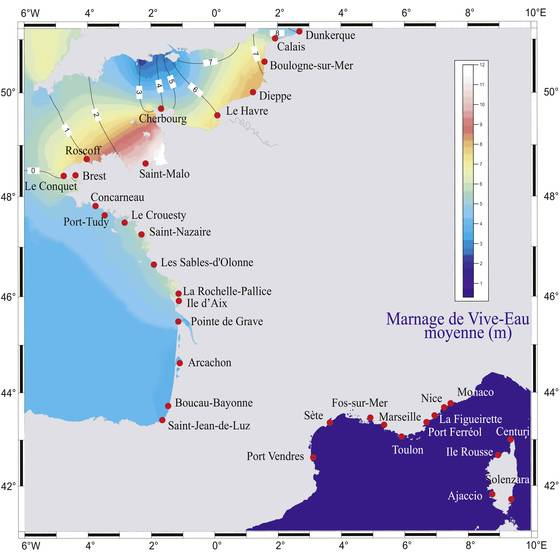
Le projet RONIM constitue le réseau marégraphique numérique national et a pour objectif la mise en place et le maintien en condition opérationnelle d’un réseau moderne de marégraphes, dans les ports principaux de France métropolitaine et d’outre-mer.
-
Réseau national de surveillance de l'état de santé des peuplements de mollusques sur les gisements naturels ou dans les zones de production conchylicole. Il assure une mission réglementaire et une activité de service public déléguée par le Ministère de l'agriculture et de la pêche à travers la DGAL (Direction générale de l'alimentation).
-
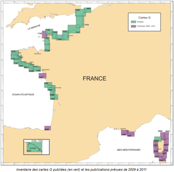
La carte G représente la nature des fonds sur un fond de carte marine utilisable pour la navigation. Publiées pour la plupart à une échelle proche du 1/50 000, elles sont autant que possible réalisées dans le cadre de collaborations avec les laboratoires universitaires ayant la connaissance de la zone à cartographier.
-
Objets linéaires du Plan cadastral de Bordeaux Métropole représentant des éléments divers tels que : tunnels, parapets de ponts, téléphériques, aqueducs, gazoducs, sentiers, amorces de voies etc...
-

Textes graphiques du Plan cadastral de Bordeaux Métropole représentant la toponymie de la voie associé à un objet ponctuel pour le placement.