 Catalogue PIGMA
Trace elements and their isotopes
Type of resources
Available actions
Topics
Keywords
Contact for the resource
Provided by
Years
Formats
-
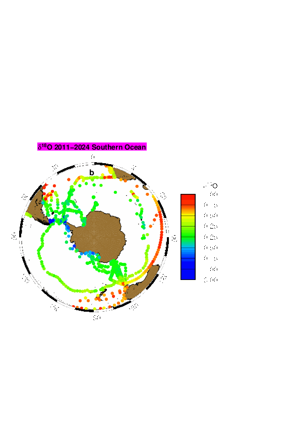
LOCEAN has been in charge of collecting sea water for the analysis of water isotopes on a series of cruises or ships of opportunity mostly in the equatorial Atlantic, in the North Atlantic, in the southern Indian Ocean, in the southern Seas, Nordic Seas, and in the Arctic. The LOCEAN data set of the oxygen and hydrogen isotope (δ18O and δD) of marine water covers the period 1998 to 2019, but the effort is ongoing. Most data prior to 2010 (only δ18O) were analyzed using isotope ratio mass spectrometry (Isoprime IRMS) coupled with a Multiprep system (dual inlet method), whereas most data since 2010 (and a few earlier data) were obtained by cavity ring down spectrometry (CRDS) on a Picarro CRDS L2130-I, or less commonly on a Picarro CRDS L2120-I. Occasionally, some data were also run by Marion Benetti on an Isoprime IRMS coupled to a GasBench (dual inlet method) at the university of Iceland (Reykjavik). On the LOCEAN Picarro CRDS, most samples were initially analyzed after distillation, but since 2016, they have often been analyzed using a wire mesh to limit the spreading of sea salt in the vaporizer. Some of the samples on the CRDS were analyzed more than once on different days, when repeatability for the same sample was not sufficient or the daily run presented a too large drift. Accuracy is best when samples are distilled, and for δD are better on the Picarro CRDS L2130-I than on the Picarro CRDS L2120-I. Usually, we found that the reproducibility of the δ18O measurements is within ± 0.05 ‰ and of the δD measurements within ± 0.30 ‰, which should be considered an upper estimate of the error on the measurement on a Picarro CRDS. The water samples were kept in darkened glass bottles (20 to 50 ml) with special caps, and were often (but not always) taped afterwards. Once brought back in Paris, the samples were often stored in a cold room (with temperature close to 4°C), in particular if they were not analyzed within the next three months. There is however the possibility that some samples have breathed during storage. We found it happening on a number of samples, more commonly when they were stored for more than 5 years before being analyzed. We also used during one cruise bottles with not well-sealed caps (M/V Nuka Arctica in April 2019), which were analyzed within 3 months, but for which close to one third of the samples had breathed. We have retained those analyses, but added a flag ‘3’ meaning probably bad, at least on d-excess (outside of regions where sea ice forms or melts, for the analyses done on the Picarro CRDS, excessive evaporation is usually found with a d-excess criterium (which tends to be too low); for the IRMS analyses, it is mostly based when excessive scatter is found in the S- δ18O scatter plots or between successive data, in which case some outliers were flagged at ‘3’). In some cases when breathing happened, we found that d-excess can be used to produce a corrected estimate of δ18O and δD (Benetti et al., 2016). When this method was used a flag ‘1’ is added, indicating ‘probably good’ data, and should be thought as not as accurate as the data with no ‘correction’, which are flagged ‘2’ or ‘0’. We have adjusted data to be on an absolute fresh-water scale based on the study of Benetti et al. (2017), and on further tests with the different wire meshes used more recently. We have also checked the consistency of the runs in time, as there could have been changes in the internal standards used. On the Isoprime IRMS, it was mostly done using different batches of ‘Eau de Paris’ (EDP), whereas on the Picarro CRDS, we used three internal standards kept in metal tanks with a slight overpressure of dry air). The internal standards have been calibrated using VSMOW and GISP, and were also sent to other laboratories to evaluate whether they had drifted since the date of creation (as individual sub-standards have typically stored for more than 5-years). These comparisons are still not fully statisfactory to evaluate possible drifts in the sub-standards. Version V5 contains only one global file (ALL-Wisotopes-V5). However, up to version V4, individual files corresponded to regional subsets : - SO: Southern Ocean including cruise station and surface data mostly from 2017 in the Weddell Sea (WAPITI Cruise JR160004, DOI:10.17882/54012), as well as in the southern Ocean south of 20°S - SI: OISO cruise station and surface data in the southern Indian Ocean (since 1998) (DOI:10.18142/228) - EA: 20°N-20°S cruise station and surface data (since 2005), in particular in the equatorial Atlantic from French PIRATA (DOI:10.18142/14) and EGEE cruises (DOI:10.18142/95) - NA: 20°N-72°N station and surface data, mostly in the North Atlantic from Oceanographic cruises as well as from ships of opportunity (this includes in particular OVIDE cruise data since 2002 (DOI:10.17882/46448), CATARINA, BOCATS1 and BOCATS2 (PID2019-104279GB-C21/AEI/10.13039/501100011033) cruises funded by the Spanish Research Agency, RREX2017 2017 cruise data (DOI:10.17600/17001400), SURATLANT data set since 2011 (DOI:10.17882/54517), Nuka Arctica and Tukuma Arctica data since 2012, STRASSE (DOI:10.17600/12040060) and MIDAS cruise data in 2012-2013, as well as surface data from various ships of opportunity since 2012) - NS: Nordic Sea data from cruises in 2002-2018 - AS: Arctic Ocean north of 72°N, in particular from two Tara cruises (in 2006-2008 and 2013) and expeditions since 2020 - PM: miscellaneous data in tropical Pacific, Indian Ocean, Mediterranean Sea and Black Sea In some regions, such as in the Indian Ocean, it is valuable to combine different subsets to have the full data distribution. The files are in csv format reported, and starting with version V1, it is reported as: - Cruise name, station id, bottle number, day, month, year, hour, minute, latitude, longitude, pressure (db), temperature (°C), it, salinity (pss-78), is, dissolved oxygen (micromol/kg), io2, δ18O, iO, d D, iD, d-excess, id, method type - Temperature is an in situ temperature - Salinity is a practical salinity it, is, io2, iO, iD, id are quality indices equal to: - 0 no quality check (but presumably good data) - 1 probably good data - 2 good data - 3 probably bad data - 4 certainly bad data - 9 missing data (and the missing data are reported with an unlikely missing value) The method type is 1 for IRMS measurements, 2 for CRDS measurement of a saline water sample, 3 for CRDS measurement of a distilled water sample.
-
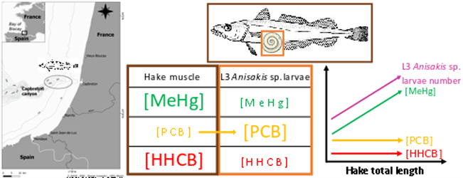
This dataset gathers isotopic ratios (carbon and nitrogen) and concentrations of both priority (mercury species and polychlorinated biphenyls congeners) and emerging (musks and sunscreens) micropollutants measured in a host-parasite couple (hake Merluccius merluccius muscle and in its parasite Anisakis sp) from the south of Bay of Biscay in 2018. In addition, the hake infection degree measured as the number of Anisakis sp. larvae was added for each hake collected.
-
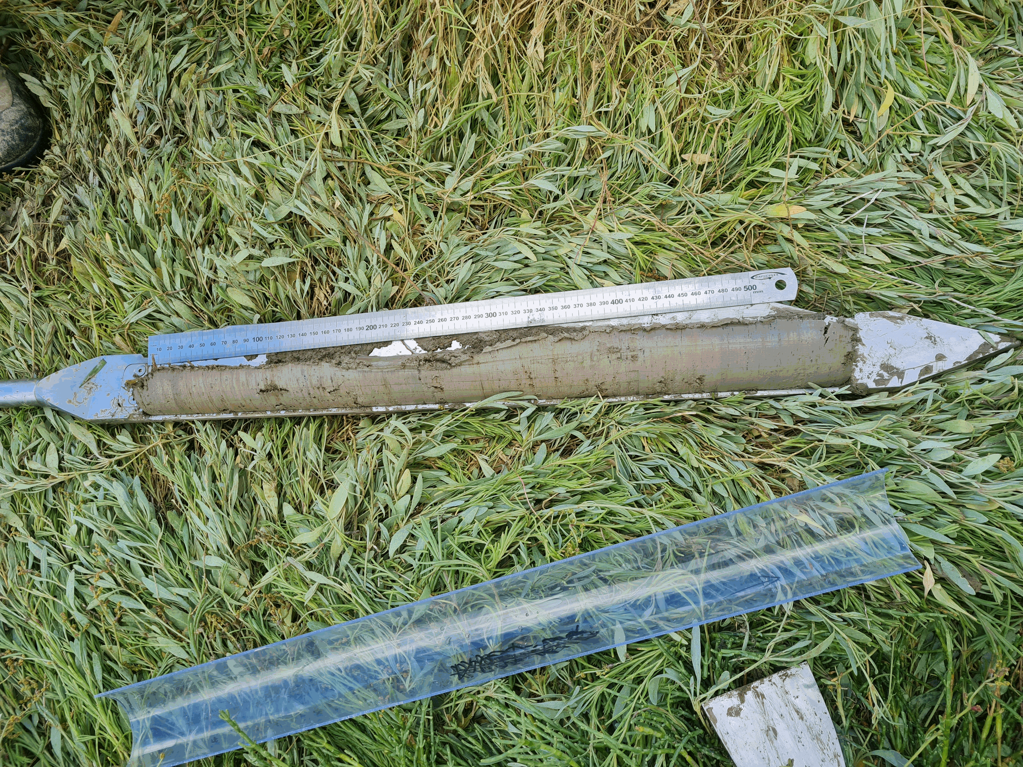
Three saltmarshes, Aiguillon, Brouage, Fier d'Ars, located in the Pertuis-Charentais Sea along the south-west coast of France, were studied to evaluate their sediment and mass accumulation rates (SAR; MAR) based on 210Pb and 137Cs profiles in sediments. Coastal saltmarshes play indeed an essential role in providing services such as coastal protection and supporting biodiversity. Saltmarshes are also critical environments for the accumulation of sedimentary organic carbon (blue carbon). However, the number of studies on saltmarshes remains underrepresented compared to studies on mangroves and seagrass. This work is a contribution to the effort to document sediment and mass accumulation rates of saltmarshes.A total of 16 1m sediment cores were collected in the three saltmarshes (Aiguillon, Brouage, Fier d'Ars) in 2021 and 2022 using an Eijkelkamp stainless steel peat sampler. Each sediment core was sampled every 1 cm from the top to the bottom of the core. The sediment layers were used to determine dry bulk density and selected radioisotope activities (210Pb, 226Ra, 137Cs, 228Th, 137Cs). Combining excess 210Pb and 137Cs has allowed to establish a reliable chronology of sediment deposition on a multidecadal timescale.
-
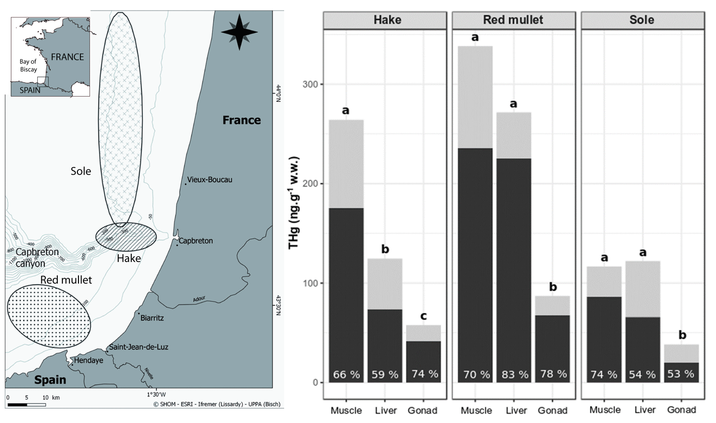
This dataset gather isotopic ratios (carbon and nitrogen) and concentrations of mercury species (methyl and inorganic mercury) measured in several tissues (muscle, liver and gonad) for three commonly consumed fish species from the south Bay of Biscay (France) in 2017 and 2018.
-
Diet and stable isotopes of the European eel (Anguilla anguilla L.) in six northern France estuaries
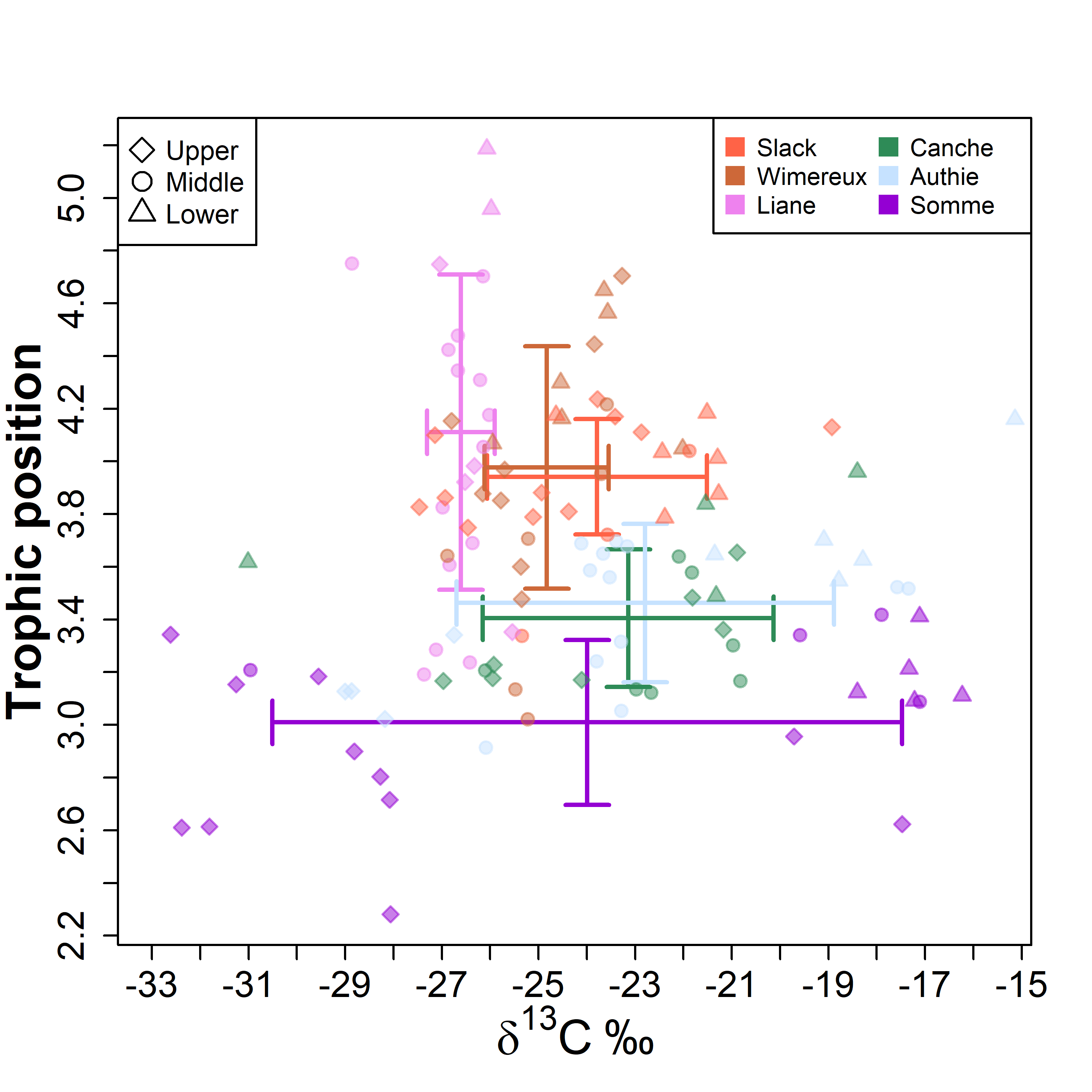
The diet and stable isotopic (i.e. δ15N and δ13C values) compositions of eels have been studied during each season of 2019 with a fyke net in six estuaries located along the French coast of the eastern English Channel (Slack, Wimereux, Liane, Canche, Authie and Somme estuaries) (10.1371/journal.pone.0270348).