 Catalogue PIGMA
phytoplankton
Type of resources
Available actions
Topics
Keywords
Contact for the resource
Provided by
Years
Formats
Representation types
Update frequencies
status
Scale
-
The PHYTOBS-MARCOBOLO dataset comprises long-term time series on marine microphytoplankton, from 2003 to 2021, along the entire French metropolitan coastline. Microphytoplankton data cover microscopic taxonomic identifications and counts. The PHYTOBS-MARCOBOLO dataset corresponds to a dataset extracted from the PHYTOBS network (DOI:10.17882/85178). The PHYTOBS network provides the scientific community and stakeholders with validated and qualified data on the biomass, abundance and composition of marine microphytoplankton in coastal and lagoon waters, with the aim of supporting scientific research. PHYTOBS-MARCOBOLO is a dataset used as part of the Horizon Europe MARCO-BOLO project (https://marcobolo-project.eu/), in which we are currently working to understand and analyze multi-decadal trends in coastal and marine biodiversity on a European scale. The PHYTOBS-MARCOBOLO dataset gathers data from 18 sampling sites, selected from the PHYTOBS-Network dataset according to requirements of time series quality and geographical location of sampling sites established as part of the MARCO-COLO project. This dataset was also formatted according to a template imposed for the European project.
-
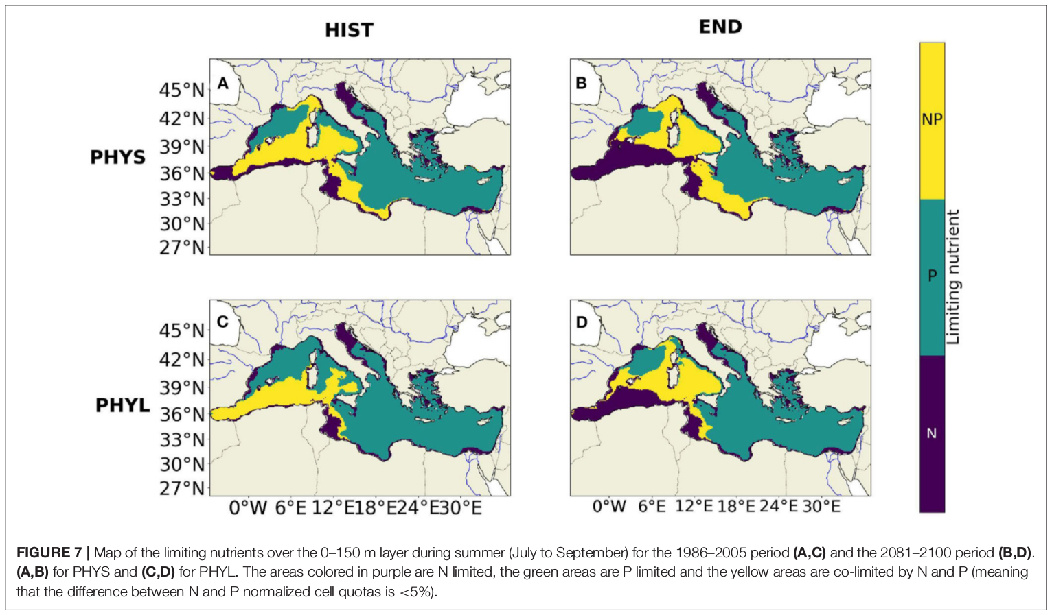
"Towards an integrated prediction of Land & Sea Responses to global change in the Mediterranean Basin" The LaSeR-Med project aims at investigating the effects of climate change and of mediterranean population growth on some major indicators of the Mediterranean Sea (primary production, carbon export, zooplankton biomass available for small pelagic fishes, pH, dissolved oxygen) using and integrated model encompassing a socio-economic model, a continental model of agro-ecosystems, and a physical ocean-atmosphere model coupled to a biogeochemical model of the ocean. Last, a model for the widespread species of jellyfish Pelagia Noctiluca (Berline et al., 2013) uses biogeochemical outputs as food forcing for the jellyfish. In this project, our aim was first to investigate the large-scale and long-term impacts of variations in river inputs on the biogeochemistry of the Mediterranean Sea over the last decades (see Pages et al., 2020a). In the second phase, a climate scenario (RCP8.5) alone (Pages et al., 2020b) or combined with a “land-use” scenario derived to ensure the same level of food availability as today in 2050 have been run to investigate its effect on these indicators and to analyze the observed changes on the structure and the functioning of planktonic food web. This interdisciplinary project provided the framework for joint discussions on each of the sub-models that constitute the integrated model, namely the socio-economic model (Ami et al., in prep., Mardesic et al., in prep.) created ex nihilo by researchers from AMSE, INRA and GREQAM, the continental agro-ecosystem model LPJmL (Bondeau et al., 2007) worked on at IMBE so as to include the nitrogen and phosphorous cycles in the frame of the present project, and the ocean biogeochemical model Eco3M-Med developed at MIO (Baklouti et al., 2006; Alekseenko et al. 2014, Guyennon et al., 2015; Pagès et al., 2020a), forced by ocean physics, either using the ocean model NEMO-Med12 forced by atmosphere at IPSL (simulation NM12-FREE run with the NEMO-MED12 model and used for our hindcast simulation, see below) or a coupled ocean-atmosphere model at CNRM (physical forcing provided by CNRM-RCSM4, see below). Details on the CNRM-RCSM4 model The CNRM-RCSM4 simulates the main components of the Mediterranean regional climate system and their interactions. It includes four different components: (i) The atmospheric regional model ALADIN-Climate (Radu et al., 2008; Colin et al., 2010; Herrmann et al., 2011) characterized by a 50 km horizontal resolution, 31 vertical levels, and a time step of 1800 s, (ii) the ISBA (Interaction between Soil Biosphere and Atmosphere) land-surface model (Noilhan and Mahfouf, 1996) at a 50 km horizontal resolution, (iii) the TRIP (Total Runoff Integrating Pathways) river routing model (Oki and Sud, 1998), used to convert the runoff simulated by ISBA into rivers (Decharme et al., 2010; Szczypta et al., 2012; Voldoire et al., 2013), and (iv) the Ocean general circulation model NEMO (Nucleus for European Modeling of the Ocean, Madec and NEMO-Team, 2016) in its NEMO-MED8 regional configuration (Beuvier et al., 2010). NEMO-MED8 is characterized by a horizontal resolution of 1/8° (grid cells size from 6 to 12 km), a vertical resolution of 43 vertical levels (cell height ranging from 6 to 200 m), and a time step of 1200 s. More details about the CNRM-RCSM4 model can be found in Sevault et al. (2014). Keywords: - Mediterranean Sea, river inputs, chlorophyll, nutrients, phytoplankton, bacteria, zooplankton, dissolved and particulate organic detrital matter Citation: Pagès, R., Baklouti, M., Barrier, N., Richon, C., Dutay, J.-C., and Moutin, T. (2020a). Changes in rivers inputs during the last decades significantly impacted the biogeochemistry of the eastern Mediterranean basin: a modelling study. Prog. Oceanogr. 181:102242. doi:10.1016/j.pocean.2019.102242 Pagès, R., Baklouti, M., Barrier, N., Ayache, M., Sevault, F., Somot, S. and Moutin, T. (2020b). Projected Effects of Climate-Induced Changes in Hydrodynamics on the Biogeochemistry of the Mediterranean Sea Under the RCP 8.5 Regional Climate Scenario. Front. Mar. Sci. 7:563615. doi:10.3389/fmars.2020.563615 Ayache, M., Bondeau, A., Pagès, R., Barrier, N., Ostberg, S. and Baklouti, M. (2020). LPJmL-Med – Modelling the dynamics of the land-sea nutrient transfer over the Mediterranean region–version 1: Model description and evaluation. Geoscientific Model Development Discussions, Copernicus Publ.
-
EMODnet Biology provides three keys services and products to users. 1)The data download toolbox allows users to explore available datasets searching by source, geographical area, and/or time period. Datasets can be narrowed down using a taxonomic criteria, whether by species group (e.g. benthos, fish, algae, pigments) or by both scientific and common name. 2) The data catalogue is the easiest way to access nearly 1000 datasets available through EMODnet Biology. Datasets can be filtered by multiple parameters via the advanced search from taxon, to institute, to geographic region. Each of the resulting datasets then links to a detailed fact sheet containing a link to original data provider, recommended citation, policy and other relevant information. Data Products - EMODnet Biology combines different data from datasets with overlapping geographic scope and produces dynamic maps of selected species abundance. The first products are already available and they focus on species whose data records are most complete and span for a longer term.
-
The European Ocean Biogeographic Information System - EurOBIS - is an online marine biogeographic database compiling data on all living marine creatures. The principle aims of EurOBIS are to centralize the largely scattered biogeographic data on marine species collected by European institutions and to make these data freely available and easily accessible. All data go through a number of quality control procedures before they are made available online, assuring a minimum level of quality necessary to put the data to good use. The available data are either collected within European marine waters or by European researchers and institutes outside Europe. The database focuses on taxonomy and distribution records in space and time; all data can be searched and visualised through a set of online mapping tools. All data are freely available online and easily accessible, without requiring a login or password.
-
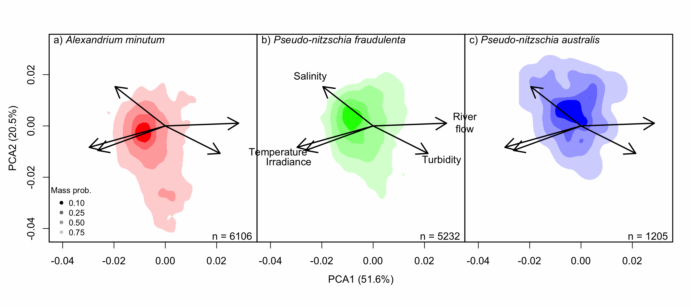
Understanding the spatial and temporal preferences of toxic phytoplankton species is of paramount importance in managing and predicting harmful events in aquatic ecosystems. In this study we address the realised niche of the species Alexandrium minutum, Pseudo-nitzschia fraudulenta and P. australis. We used them to highlight distribution patterns at different scales and determine possible drivers. To achieve this, we have developed original procedures coupling niche theory and habitat suitability modelling using abundance data in four consecutive steps: 1) Estimate the realised niche applying kernel functions. 2) Assess differences between the species’ niche as a whole and at the local level. 3) Develop habitat and temporal suitability models using niche overlap procedures. 4) Explore species temporal and spatial distributions to highlight possible drivers. Data used are species abundance and environmental variables collected over 27 years (1988-2014) and include 139 coastal water sampling sites along the French Atlantic coast. Results show that A. minutum and P. australis niches are very different, although both species have preference for warmer months. They both respond to decadal summer NAO but in the opposite way. P. fraudulenta realised niche lies in between the two other species niches. It also prefers warmer months but does not respond to decadal summer NAO. The Brittany peninsula is now classified as an area of prevalence for the three species. The methodology used here will allow to anticipate species distribution in the event of future environmental challenges resulting from climate change scenarios.
-

The International Council for the Exploration of the Sea (ICES), is a global organization that develops science and advice to support the sustainable use of the oceans. ICES is a network of more than 5,000 scientists from over 690 marine institutes in 20 member countries and beyond. 1,500 scientists participate in our activities annually. ICES has a well-established Data Centre, which manages a number of large dataset collections related to the marine environment. The majority of data – covering the Northeast Atlantic, Baltic Sea, Greenland Sea, and Norwegian Sea – originate from national institutes that are part of the ICES network. The ICES Data Centre provides marine data services to ICES member countries, expert groups, world data centres, regional seas conventions (HELCOM and OSPAR), the European Environment Agency (EEA), Eurostat, and various other European projects and biodiversity portals. ICES aims to provide all data collections online and according to the ICES Data policy, which enables open access to all data that are do not fall under specific commercial or personal privacy concerns.