 Catalogue PIGMA
biodiversity
Type of resources
Available actions
Topics
Keywords
Contact for the resource
Provided by
Years
Formats
Representation types
Update frequencies
Scale
-
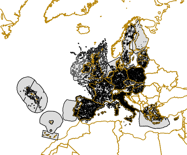
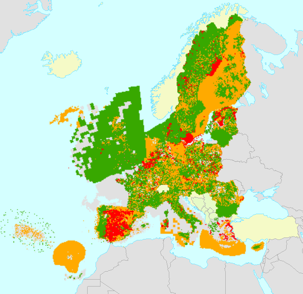
Gridded Distribution of Species as reported during the Article 17 of the Habitats Directive (92/43/EEC) covering the period 2001 to 2006. The data covers the EU 25. All Member States are requested by the Habitats Directive (92/43/EEC) to monitor habitat types and species considered to be of Community interest. Article 17 of the Habitats Directive 92/43/EEC requires that every 6 years Member States prepare reports to be sent to the European Commission on the implementation of the Directive. The Article 17 report for the period 2001-2006 for the first time includes assessments on the conservation status of the habitat types and species of Community interest. Information on the data quality of the 2001-2006 reporting round is available at http://bd.eionet.europa.eu/article17.
-
EMODnet Biology provides three keys services and products to users. 1)The data download toolbox allows users to explore available datasets searching by source, geographical area, and/or time period. Datasets can be narrowed down using a taxonomic criteria, whether by species group (e.g. benthos, fish, algae, pigments) or by both scientific and common name. 2) The data catalogue is the easiest way to access nearly 1000 datasets available through EMODnet Biology. Datasets can be filtered by multiple parameters via the advanced search from taxon, to institute, to geographic region. Each of the resulting datasets then links to a detailed fact sheet containing a link to original data provider, recommended citation, policy and other relevant information. Data Products - EMODnet Biology combines different data from datasets with overlapping geographic scope and produces dynamic maps of selected species abundance. The first products are already available and they focus on species whose data records are most complete and span for a longer term.
-
The European Ocean Biogeographic Information System - EurOBIS - is an online marine biogeographic database compiling data on all living marine creatures. The principle aims of EurOBIS are to centralize the largely scattered biogeographic data on marine species collected by European institutions and to make these data freely available and easily accessible. All data go through a number of quality control procedures before they are made available online, assuring a minimum level of quality necessary to put the data to good use. The available data are either collected within European marine waters or by European researchers and institutes outside Europe. The database focuses on taxonomy and distribution records in space and time; all data can be searched and visualised through a set of online mapping tools. All data are freely available online and easily accessible, without requiring a login or password.
-
All Member States are requested by the Habitats Directive (92/43/EEC) to monitor habitat types and species listed in its annexes and send a report every 6 years following an agreed format. The assessment of conservation status is based on information about the status and trends of species populations and of habitats at the level of the biogeographical or marine region. The spatial dataset contains habitat and species distribution data (10km grid cells) as reported by Member States for the 2013-2018 period. This metadata refers to the public dataset, without sensitive species. The data sets are divided in two sets for species and two sets for habitat types. Species: ART17 species distribution MS (by Member State) ART17 species distribution EU (European Union aggregate) Habitats: ART17 habitats distribution MS (by Member State) ART17 habitats distribution EU (European Union aggregate) Both MS datasets are aggregated by habitat/species code, country and biogeographical /marine region [CO_MS_RE]. Using this attribute [CO_MS_RE] the tabular conservation status, which is available in the table, per biogeographical/marine region of the Member State level (MS) can be joined directly to the spatial dataset. Both EU datasets are aggregated by habitat/species code and biogeographical /marine region [CO_RE]. Using this attribute [CO_RE] the tabular conservation status, which is available in the table, of the biogeographical/marine region of the EU-28 level (EU) can be directly joined to the spatial dataset. Further description of the Article 17 tabular and spatial dataset and a Article 17 web tool can be accessed with the download data.
-
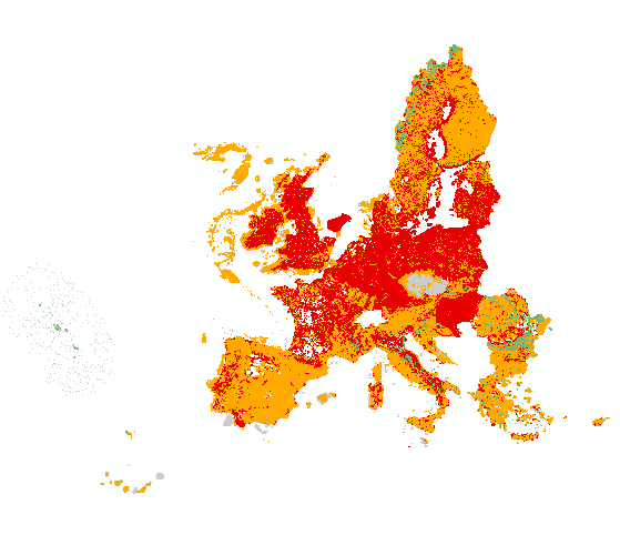
All Member States are requested by the Habitats Directive (92/43/EEC) to monitor habitat types and species listed in its annexes and send a report every 6 years following an agreed format. The assessment of conservation status is based on information about the status and trends of species populations and of habitats at the level of the biogeographical or marine region. The spatial dataset contains habitat and species distribution data (10km grid cells) as reported by EU 27 (2007-2013) Member States for the 2007-2012 period. This metadata refers to the public dataset, without sensitive species. The data sets are divided in two sets for species and two sets for habitat types. Habitats: Art17_habitats_distribution_2007_2012_EU (distribution by European Union aggregate) Art17_habitats_distribution_2007_2012_MS (distribution by Member State) Species: Art17_species_distribution_2007_2012_EU (distribution by European Union aggregate) Art17_species_distribution_2007_2012_MS (distribution by Member State) Furthermore, a series of tables are also provided with the assessments of conservation status of species and habitats at Member State biogeographical level (done by Member States) and at EU biogeographical level (done by the ETC/BD and the EEA). Both MS datasets are aggregated by habitat/species code, country and biogeographical /marine region [COMSRE]. Using this attribute [COMSRE] the tabular conservation status, which is available in the table, per biogeographical/marine region of the Member State level (MS) can be joined directly to the spatial dataset. Both EU datasets are aggregated by habitat/species code and biogeographical /marine region [CORE]. Using this attribute [CORE] the tabular conservation status, which is available in the table, of the biogeographical/marine region of the EU-27 (2007-2013) level (EU) can be directly joined to the spatial dataset. NOTE: The original datasets have been reviewed and re-published in February 2021, including delayed deliveries from Greece.
-

The International Council for the Exploration of the Sea (ICES), is a global organization that develops science and advice to support the sustainable use of the oceans. ICES is a network of more than 5,000 scientists from over 690 marine institutes in 20 member countries and beyond. 1,500 scientists participate in our activities annually. ICES has a well-established Data Centre, which manages a number of large dataset collections related to the marine environment. The majority of data – covering the Northeast Atlantic, Baltic Sea, Greenland Sea, and Norwegian Sea – originate from national institutes that are part of the ICES network. The ICES Data Centre provides marine data services to ICES member countries, expert groups, world data centres, regional seas conventions (HELCOM and OSPAR), the European Environment Agency (EEA), Eurostat, and various other European projects and biodiversity portals. ICES aims to provide all data collections online and according to the ICES Data policy, which enables open access to all data that are do not fall under specific commercial or personal privacy concerns.