 Catalogue PIGMA
initiative
Type of resources
Available actions
Topics
Keywords
Contact for the resource
Provided by
Years
Formats
Representation types
status
-
NAUTILOS, a Horizon 2020 Innovation Action project funded under EU’s the Future of Seas and Oceans Flagship Initiative, aims to fill in marine observation and modelling gaps for biogeochemical, biological and deep ocean physics essential ocean variables and micro-/nano-plastics, by developing a new generation of cost-effective sensors and samplers, their integration within observing platforms and deployment in large-scale demonstrations in European seas. The principles underlying NAUTILOS are those of the development, integration, validation and demonstration of new cutting-edge technologies with regards to sensors, interoperability and embedding skills. The development is always guided by the objectives of scalability, modularity, cost-effectiveness, and open-source availability of software products produced. Bringing together 21 entities from 11 European countries with multidisciplinary expertise, NAUTILOS has the fundamental aim to complement and expand current European observation tools and services, to obtain a collection of data at a much higher spatial resolution, temporal regularity and length than currently available at the European scale, and to further enable and democratize the monitoring of the marine environment to both traditional and non-traditional data users.
-

Businesses, policymakers, and local communities need to access reliable weather and climate information to safeguard human health, wellbeing, economic growth, and environmental sustainability. However, important changes in climate variability and extreme weather events are difficult to pinpoint and account for in existing modelling and forecasting tools. Moreover, many changes in the global climate are linked to the Arctic, where climate change is occurring rapidly, making weather and climate prediction a considerable challenge. Blue-Action evaluated the impact of Arctic warming on the northern hemisphere and developed new techniques to improve forecast accuracy at sub-seasonal to decadal scales. Blue-Action specifically worked to understand and simulate the linkages between the Arctic and the global climate system, and the Arctic’s role in generating weather patterns associated with hazardous conditions and climatic extremes. In doing so, Blue-Action aimed to improve the safety and wellbeing of people in the Arctic and across the Northern Hemisphere, reduce the risks associated with Arctic operations and resource exploitation, and support evidence-based decision-making by policymakers worldwide.
-
The All-Atlantic Ocean Research and Innovation Alliance (AAORIA) is the result of science diplomacy efforts involving countries from both sides of the Atlantic Ocean. It builds upon the success of two existing cooperative agreements – the Galway Statement on Atlantic Ocean Cooperation which was signed by the European Union, United States, and Canada in 2013; and the Belem Statement on Atlantic Ocean Research and Innovation Cooperation which was signed by the European Union, Brazil, and South Africa in 2017 as well as on several other bilateral and multilateral agreements. AAORIA aims to enhance marine research and innovation cooperation along and across the Atlantic Ocean. In 2022, the “All-Atlantic Declaration” was signed to revitalize collaboration among current initiatives and enhance the coordination between the Galway Working Groups, All-Atlantic Joint Pilot Actions, and related projects. Additionally, it aims to engage new partners and initiatives to join the All-Atlantic community.
-
Blue-Cloud 2026 is a collaborative project that leverages Europe's expertise in aquatic environmental observation and data handling. Building on existing infrastructures like Copernicus and EMODnet, Blue-Cloud aims to create a federated ecosystem for FAIR and open data in marine research. Through a web-based platform, it offers simplified access to multidisciplinary datasets, analytical services, and computing facilities. Over 42 months, Blue-Cloud 2026 will expand its core services, integrate more analytical tools, and enhance data discovery and access. With a focus on supporting the EU Blue Economy and environmental agendas, it strives to contribute to the EU Green Deal and UN Sustainable Development Goals. Coordinated by CNR, Trust-IT Services, and MARIS, the project brings together a dedicated team of 40 partners from 13 EU countries.
-
The North East Atlantic Fisheries Commission (NEAFC) is the Regional Fisheries Management Organisation (RFMO) for the North East Atlantic, one of the most abundant fishing areas in the world. It is comprised of Contracting Parties which have signed up to the Convention on Multilateral Cooperation in North East Atlantic Fisheries, which entered into force in November 1982. The area covered by the NEAFC Convention stretches from the southern tip of Greenland, east to the Barents Sea, and south to Portugal. Most of the information on this website is aimed at scientists, control experts, statisticians and managers from the Contracting Parties and other international organisations. The objective of NEAFC is to ensure the long-term conservation and optimum utilisation of the fishery resources in its Convention Area, providing sustainable economic, environmental and social benefits.
-
The technologies developed will expand our knowledge of the ocean’s interconnected systems and provide tangible benefits to the industries that rely on them, such as fisheries and aquaculture. The data generated will also support conservation initiatives and provide vital information to policy makers. The future impact of these valuable technologies relies on their accessibility. Therefore, TechOceanS technology pilots will be low-cost and place minimal demands on existing infrastructure, allowing them to be made available for use by all countries regardless of resources. TechOceanS will also work with the IOC-UNESCO to develop “ocean best practices” standards for training and monitoring of metrology and ocean systems.
-
The Continuous Plankton Recorder (CPR) Survey is the most geographically extensive marine monitoring programme in the world. Today the Survey is operated by the Marine Biological Association, based in Plymouth, UK. Operating since 1931, the Continuous Plankton Recorder (CPR) survey is recognised as the longest sustained and geographically most extensive marine biological survey in the world. The dataset comprises a uniquely large record of marine biodiversity covering ~800 taxa over multi-decadal periods. In terms of our scientific understanding of natural variability and human-induced change on our oceans, the CPR survey is of global importance and it is used by scientists, policy makers and environmental managers across the world. The data is used to examine strategically important science pillars such as climate change, human health, fisheries, biodiversity, pathogens, invasive species, ocean acidification and natural capital. The results have included the globally first documented studies of large-scale ecological regime shifts, and of biogeographic, phenological and trans-arctic migrations in the marine environment in response to climate change. The data in this sampling event resource has been published as a Darwin Core Archive (DwC-A), which is a standardized format for sharing biodiversity data as a set of one or more data tables. The core data table contains 252,385 records. 2 extension data tables also exist. An extension record supplies extra information about a core record. The number of records in each extension data table is illustrated below.
-

OSPAR is the mechanism by which 15 Governments & the EU cooperate to protect the marine environment of the North-East Atlantic. OSPAR started in 1972 with the Oslo Convention against dumping and was broadened to cover land-based sources of marine pollution and the offshore industry by the Paris Convention of 1974. These two conventions were unified, up-dated and extended by the 1992 OSPAR Convention. The new annex on biodiversity and ecosystems was adopted in 1998 to cover non-polluting human activities that can adversely affect the sea. The fifteen Governments are Belgium, Denmark, Finland, France, Germany, Iceland, Ireland, Luxembourg, The Netherlands, Norway, Portugal, Spain, Sweden, Switzerland and United Kingdom. OSPAR is so named because of the original Oslo and Paris Conventions ("OS" for Oslo and "PAR" for Paris). OSPAR Data & Information Management System (ODIMS) is a fully featured platform for accessing OSPAR's geospatial maps, data and metadata. 61 Maps and 254 layers regarding: - Cables and pipelines - Comprehensive atmospheric monitoring programme - Discharges of radionuclides from the non-nuclear sectors - Discharges, spills and emissions from offshore oil and gas installations - Dumping and placement of wastes or other matter at sea - Environmental monitoring of radioactive substances - Fishing for litter - Vulnerable marine ecosystems - etc.
-
The International Whaling Commission was set up under the International Convention for the Regulation of Whaling which was signed in Washington DC on 2nd December 1946. The preamble to the Convention states that its purpose is to provide for the proper conservation of whale stocks and thus make possible the orderly development of the whaling industry. The Commission undertakes extensive study and research on cetacean populations, develops and maintains scientific databases, and publishes its own peer reviewed scientific journal, the Journal of Cetacean Research and Management. A list of catches since the moratorium came into place (in the 1985/6 Antarctic Season) up to 2019 (download link).
-
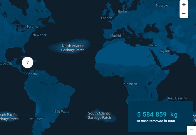
Every year, millions of tons of plastic enter the oceans, of which the majority spills out from rivers. A portion of this plastic travels to ocean garbage patches, where it gets caught in a vortex of circulating currents alongside plastic from other sources (e.g. offshore fishing activities). If no action is taken, plastic will increasingly impact our ecosystems, health, and economies. The Ocean Cleanup is a non-profit organization developing and scaling technologies to rid the oceans of plastic. To achieve this objective, we have to work on a combination of closing the sources of plastic pollution and cleaning up what has already accumulated in the ocean and doesn’t go away by itself. This goal means we plan to put ourselves out of business – once we have completed this project, our work is done. To rid the oceans of plastic, we need not only to clean up what is already out there but also stop new plastic from entering the ocean – we need to close the tap. Working together with government leaders, individuals, and private corporations, our goal is to tackle these 1000 most polluting rivers all over the world Every single year, marine plastic costs the economy (6 to 19) billions of dollars – impacting tourism, fisheries and aquaculture, and (governmental) cleanups. And that doesn’t include the impact on our health and on the marine ecosystem. Intercepting plastic in rivers is much more cost-effective than dealing with the consequences downstream.