 Catalogue PIGMA
NC, NETCDF
Type of resources
Available actions
Topics
Keywords
Contact for the resource
Provided by
Years
Formats
-
The glider operations in the MOOSE network started to be deployed regularly in 2010 in the North Western Mediterranean Sea, thanks to the setup of national glider facilities at DT-INSU/Ifremer (http://www.dt.insu.cnrs.fr/gliders/gliders.php) and with the support of the European project FP7-PERSEUS. Two endurance lines are operated: MooseT00 (Nice-Calvi; Ligurian Sea) and MooseT02 (Marseille-Menorca; Gulf of Lion). The all dataset here corresponds to raw data in the EGO format.
-
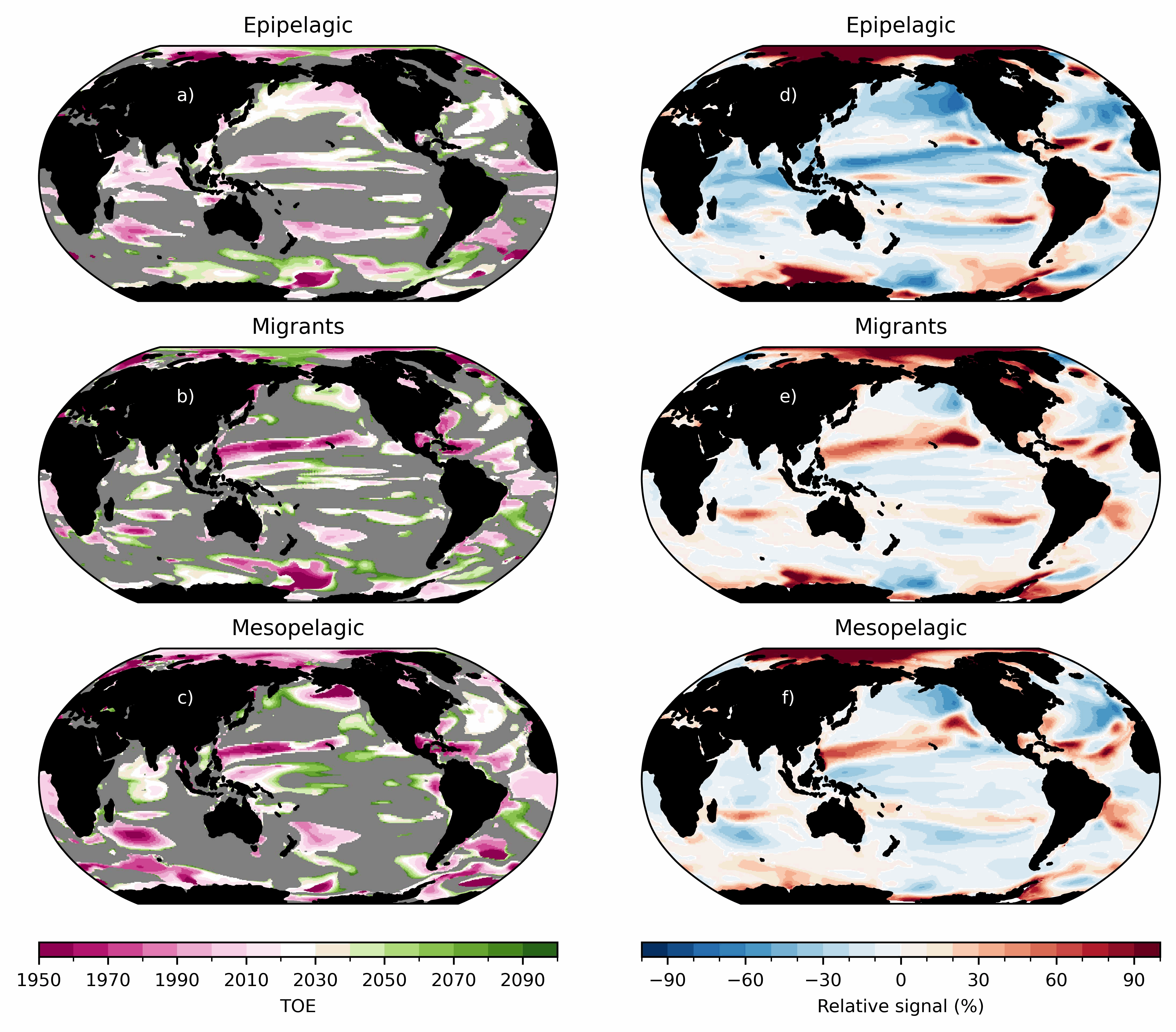
Ensemble simulations of the ecosystem model Apecosm (https://apecosm.org) forced by the IPSL-CM6-LR climate model with the climate change scenario SSP5-8.5. The output files contain yearly mean biomass density for 3 communities (epipelagic, mesopelagic migratory and mesopelagic redidents) and 100 size classes (ranging from 0.12cm to 1.96m) The model grid file is also provided. Units are in J/m2 and can be converted in kg/m2 by dividing by 4e6. These outputs are associated with the "Assessing the time of emergence of marine ecosystems from global to local scales using IPSL-CM6A-LR/APECOSM climate-to-fish ensemble simulations" paper from the Earth's Future "Past and Future of Marine Ecosystems" Special Collection.
-
Observations of Sea surface temperature and salinity are now obtained from voluntary sailing ships using medium or small size sensors. They complement the networks installed on research vessels or commercial ships. The delayed mode dataset proposed here is upgraded annually as a contribution to GOSUD (http://www.gosud.org )
-

This dataset contains the dynamical outputs of a global ocean simulation coupling dynamics and biogeochemistry at ¼° over the year 2019. The simulation has been performed using the coupled circulation/ecosystem model NEMO/PISCES (https://www.nemo-ocean.eu/), which is here enhanced to perform an ensemble simulation with explicit simulation of modeling uncertainties in the physics and in the biogeochemistry. This dataset is one of the 40 members of the ensemble simulation. This study was part of the Horizon Europe project SEAMLESS (https://seamlessproject.org/Home.html), with the general objective of improving the analysis and forecast of ecosystem indicators. See Popov et al. (https://os.copernicus.org/articles/20/155/2024/) for more details on the study.
-
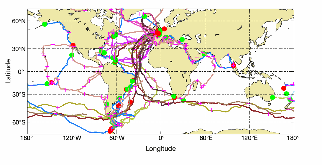
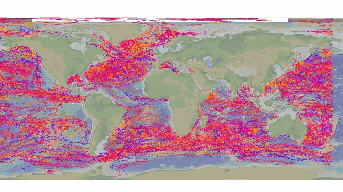
This delayed mode product designed for reanalysis purposes integrates the best available version of in situ data for ocean surface currents and current vertical profiles. It concerns three delayed time datasets dedicated to near-surface currents measurements coming from three platforms (Lagrangian surface drifters, High Frequency radars and Argo floats) and velocity profiles within the water column coming from the Acoustic Doppler Current Profiler (ADCP, vessel mounted only). The latest version of Copernicus surface and sub-surface water velocity product is also distributed from Copernicus Marine catalogue.
-
The DBCP – Data Buoy Cooperation Panel - is an international program coordinating the use of autonomous data buoys to observe atmospheric and oceanographic conditions, over ocean areas where few other measurements are taken. DBCP coordinates the global array of 1 600 active drifting buoys (August 2020) and historical observation from 14 000 drifting buoys. Data and metadata collected by drifting buoys are publically available in near real-time via the Global Data Assembly Centers (GDACs) in Coriolis-Ifremer (France) and MEDS (Canada) after an automated quality control (QC). In long term, scientifically quality controlled delayed mode data will be distributed on the GDACs. Disclaimer: the DB-GDAC is under construction. It is currently (January 2020) aggregating data from the Coriolis DAC (E-Surfmar, Canada). Additional DACs are considered. An interim provision from GTS real-time data to GDAC may be provided from Coriolis DAC.
-
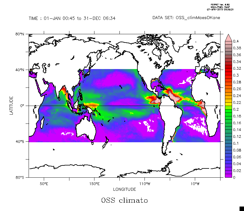
This dataset is composed by the climatological seasonal field of the Ocean Salinity Stratification as defined from the Brunt-Vaisala frequency limited to the upper 300 m depth. The details are given in Maes, C., and T. J. O’Kane (2014), Seasonal variations of the upper ocean salinity stratification in the Tropics, J. Geophys. Res. Oceans, 119, 1706–1722, doi:10.1002/2013JC009366.
-
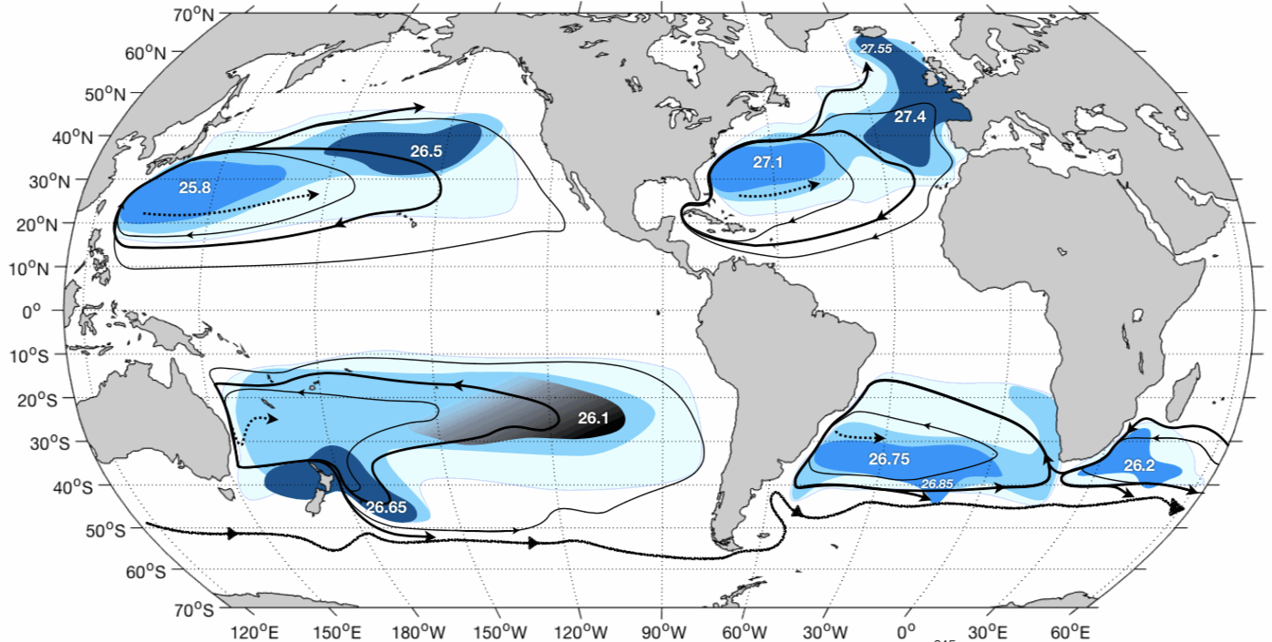
This dataset contains OAC-P results from application to Argo data in the World Ocean : - the 2000-2015 climatology of OAC-P results mapped onto a 0.5x0.5 grid with mapping error estimates; - the 2000-2015 probability density function of the permanent pycnocline potential density referenced to the sea surface vs Brunt-Väisälä frequency squared.OAC-P is an "Objective Algorithm for the Characterization of the permanent Pycnocline" developed to characterize subtropical gyre stratification features with both observed and modeled potential density profiles. OAC-P estimates the following properties: - for the permanent pycnocline: depth, upper and lower thicknesses, Brunt-Väisälä frequency squared, potential density, temperature and salinity; - for the surface mode water overlying the permanent pycnocline: depth, Brunt-Väisälä frequency squared, potential density, temperature and salinity. Argo data were download from Coriolis Argo GDAC on February, 8th 2016. Only Argo data with QC=1, 2, 5 or 8 were used.
-
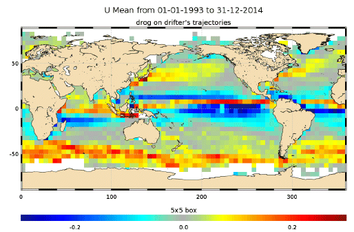
The In Situ delayed mode product designed for reanalysis purposes integrates the best available version of in situ data for ocean surface currents. The data are collected from the Surface Drifter Data Assembly Centre (SD-DAC at NOAA AOML). All surface drifters data have been processed to check for drogue loss. Drogued and undrogued drifting buoy surface ocean currents are provided with a drogue presence flag as well as a wind slippage correction for undrogued buoys. Altimeter and wind data have been used to extract the direct wind slippage from the total drifting buoy velocities. This product is designed to be assimilated into or for validation purposes of operational models operated by ocean forecasting centers for reanalysis purposes or for research community. These users need data aggregated and quality controlled in a reliable and documented manner.
-

This dataset contains (1) outputs of Species Distribution Models (SDMs) for marine fish and (2) estimation of species richness using those outputs. SDMs use correlative algorithms to link presences of species to the environment recorded in place and time of their observation, calculate their environmental niche, estimate the geographical location suitable for them (habitat suitability) and in fine their geographical distribution. Here, we downloaded presences of marine fish from two open source databases, GBIF and OBIS and 13 environmental predictors known to be relevant in fish ecology (list below). We used the CEPHALOPOD pipeline, a framework allowing the user the compute a lot of species at the same time, with comparable methods and a verification of quality of inputs and outputs at every steps (Schickele et al., 2025). 3,642 fish made it to the final step and have the habitat suitability estimated for 12 month + annual mean, 10 bootstrap to quantify uncertainty and x algorithms. Those estimation are available in the “L2_marine_fish_*.nc” files, organized by water column position (bathydemersal, bathypelagic, benthopelagic, demersal, pelagic-neritic, pelagic-oceanic, reef-associated). We then used their annual mean to estimate their actual geographic distribution by applying (1) a bathymetric filtration and (2) a cutting procedure which removes isolated patches of high suitability (i.e., potential distribution) with no recorded presences (i.e., considered to be outside of the species dispersion range). Those geographic distribution were then stacked to estimate global species richness of every fish and each water column position.