 Catalogue PIGMA
Date and time
Type of resources
Available actions
Topics
Keywords
Contact for the resource
Provided by
Years
Formats
Representation types
Update frequencies
status
Scale
Resolution
-
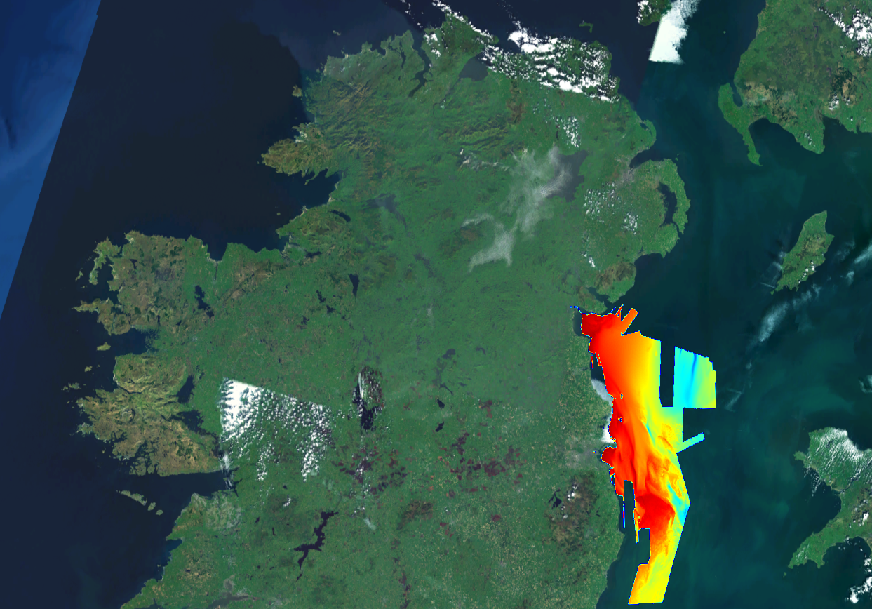
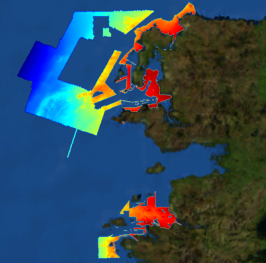
This composite Digital Terrain Model (cDTM) is a high resolution bathymetry dataset highlighting measurement of depth of water in the ocean. This cDTM covers the Irish Sea North off the coasts of counties Wicklow, Dublin, Meath and Louth in Ireland. The EMODnet high resolution DTM covers bathymetry surveys completed between 2002 and 2019. Bathymetric data collected on board research vessels using multi-beam and single-beam echosounder instrumentation. Raw bathymetry processed within CARIS software to produce bathymetry products subsequently converted to NetCDF cDTM for EMODnet. Acquisition, processing and product delivery follows IHO standard s44 Edition 5. cDTM is composed of twenty-two (22) images “merged simply” using GLOBE software. INFOMAR (Integrated Mapping for the Sustainable Development of Ireland’s Marine Resource) is a twenty year programme to map the physical, chemical and biological features of Ireland’s seabed established in 2006. INFOMAR is funded by the Department of Communications, Climate Action and Environment (DCCAE), and delivered by joint management partners Geological Survey Ireland and the Marine Institute. The programme is the successor to the Irish National Seabed Survey (INSS) which ran between 1999 and 2005. INFOMAR concentrates on creating integrated mapping products related to the seabed.
-
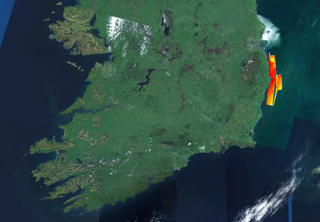
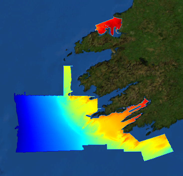
This composite Digital Terrain Model (cDTM) is a high resolution bathymetry dataset highlighting measurement of depth of water in the ocean. This cDTM covers the Irish Sea South off the coasts of counties Dublin, Wicklow and Wexford in Ireland. The EMODnet high resolution DTM covers bathymetry surveys completed between 2002 and 2018. Bathymetric data collected on board research vessels using multi-beam and single-beam echosounder instrumentation. Raw bathymetry processed within CARIS software to produce bathymetry products subsequently converted to NetCDF cDTM for EMODnet. Acquisition, processing and product delivery follows IHO standard s44 Edition 5. cDTM is composed of eight (8) images “merged simply” using GLOBE software. INFOMAR (Integrated Mapping for the Sustainable Development of Ireland’s Marine Resource) is a twenty year programme to map the physical, chemical and biological features of Ireland’s seabed established in 2006. INFOMAR is funded by the Department of Communications, Climate Action and Environment (DCCAE), and delivered by joint management partners Geological Survey Ireland and the Marine Institute. The programme is the successor to the Irish National Seabed Survey (INSS) which ran between 1999 and 2005. INFOMAR concentrates on creating integrated mapping products related to the seabed.
-

This composite Digital Terrain Model (cDTM) is a high resolution bathymetry dataset highlighting measurement of depth of water in the ocean. This cDTM covers the Irish Sea South East off the coasts of counties Wexford and Waterford in Ireland. The EMODnet high resolution DTM covers bathymetry surveys completed between 2002 and 2016. Bathymetric data collected on board research vessels using multi-beam and single-beam echosounder instrumentation. Raw bathymetry processed within CARIS software to produce bathymetry products subsequently converted to NetCDF cDTM for EMODnet. Acquisition, processing and product delivery follows IHO standard s44 Edition 5. cDTM is composed of three (3) images “merged simply” using GLOBE software. INFOMAR (Integrated Mapping for the Sustainable Development of Ireland’s Marine Resource) is a twenty year programme to map the physical, chemical and biological features of Ireland’s seabed established in 2006. INFOMAR is funded by the Department of Communications, Climate Action and Environment (DCCAE), and delivered by joint management partners Geological Survey Ireland and the Marine Institute. The programme is the successor to the Irish National Seabed Survey (INSS) which ran between 1999 and 2005. INFOMAR concentrates on creating integrated mapping products related to the seabed.
-
This composite Digital Terrain Model (cDTM) is a high resolution bathymetry dataset highlighting measurement of depth of water in the ocean. This cDTM covers the North Atlantic Ocean off the coast of counties Mayo and Galway in Ireland. The EMODnet high resolution DTM covers bathymetry surveys completed between 2002 and 2016. Bathymetric data collected on board research vessels using multi-beam and single-beam echosounder instrumentation. Raw bathymetry processed within CARIS software to produce bathymetry products subsequently converted to NetCDF cDTM for EMODnet. Acquisition, processing and product delivery follows IHO standard s44 Edition 5. cDTM is composed of six (6) images “merged simply” using GLOBE software. INFOMAR (Integrated Mapping for the Sustainable Development of Ireland’s Marine Resource) is a twenty year programme to map the physical, chemical and biological features of Ireland’s seabed established in 2006. INFOMAR is funded by the Department of Communications, Climate Action and Environment (DCCAE), and delivered by joint management partners Geological Survey Ireland and the Marine Institute. The programme is the successor to the Irish National Seabed Survey (INSS) which ran between 1999 and 2005. INFOMAR concentrates on creating integrated mapping products related to the seabed.
-

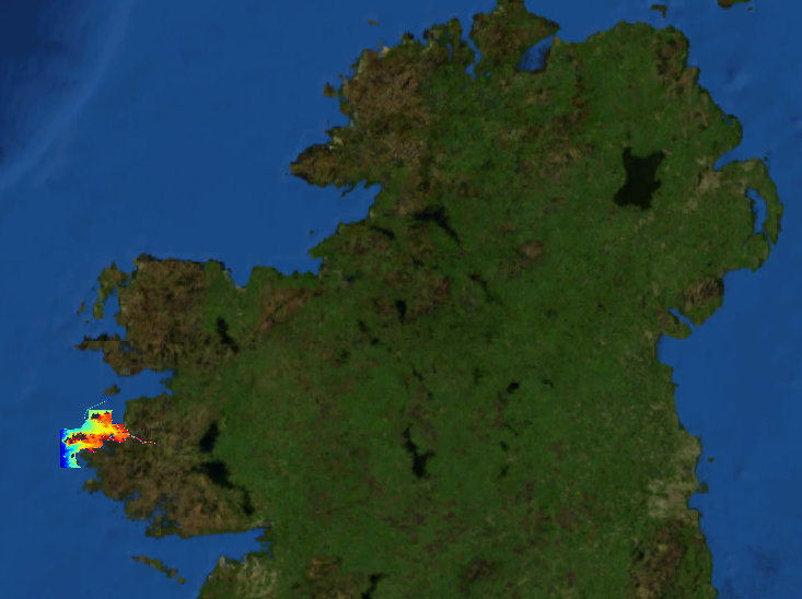
This composite Digital Terrain Model (cDTM) is a high resolution bathymetry dataset highlighting measurement of depth of water in the ocean. This cDTM covers the North Atlantic Ocean around the mouth of the River Shannon off the coast of County Limerick in Ireland. The EMODnet high resolution DTM covers bathymetry surveys completed between 2002 and 2016. Bathymetric data collected on board research vessels using multi-beam and single-beam echosounder instrumentation. Raw bathymetry processed within CARIS software to produce bathymetry products subsequently converted to NetCDF cDTM for EMODnet. Acquisition, processing and product delivery follows IHO standard s44 Edition 5. cDTM is composed of three (3) images “merged simply” using GLOBE software. INFOMAR (Integrated Mapping for the Sustainable Development of Ireland’s Marine Resource) is a twenty year programme to map the physical, chemical and biological features of Ireland’s seabed established in 2006. INFOMAR is funded by the Department of Communications, Climate Action and Environment (DCCAE), and delivered by joint management partners Geological Survey Ireland and the Marine Institute. The programme is the successor to the Irish National Seabed Survey (INSS) which ran between 1999 and 2005. INFOMAR concentrates on creating integrated mapping products related to the seabed.
-
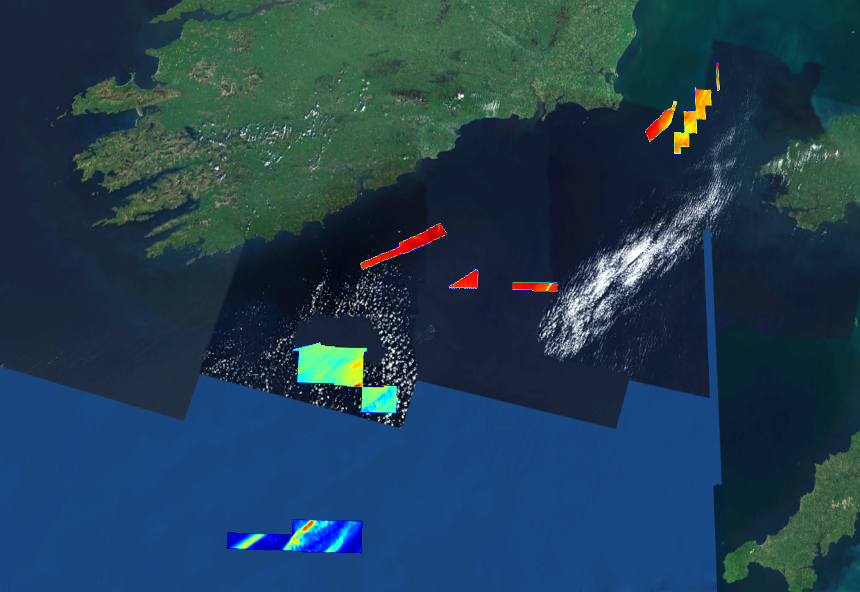
This composite Digital Terrain Model (cDTM) is a high resolution bathymetry dataset highlighting measurement of depth of water in the ocean. This cDTM covers the Celtic Sea off the coast of counties Cork, Waterford and Wexford in Ireland. The EMODnet high resolution DTM covers bathymetry surveys completed between 2002 and 2016. Bathymetric data collected on board research vessels using multi-beam and single-beam echosounder instrumentation. Raw bathymetry processed within CARIS software to produce bathymetry products subsequently converted to NetCDF cDTM for EMODnet. Acquisition, processing and product delivery follows IHO standard s44 Edition 5. cDTM is composed of four (4) images “merged simply” using GLOBE software. INFOMAR (Integrated Mapping for the Sustainable Development of Ireland’s Marine Resource) is a twenty year programme to map the physical, chemical and biological features of Ireland’s seabed established in 2006. INFOMAR is funded by the Department of Communications, Climate Action and Environment (DCCAE), and delivered by joint management partners Geological Survey Ireland and the Marine Institute. The programme is the successor to the Irish National Seabed Survey (INSS) which ran between 1999 and 2005. INFOMAR concentrates on creating integrated mapping products related to the seabed.
-
This composite Digital Terrain Model (cDTM) is a high resolution bathymetry dataset highlighting measurement of depth of water in the ocean. This cDTM covers the North Atlantic Ocean off the southwest coast of Ireland. The EMODnet high resolution DTM covers bathymetry surveys completed between 2002 and 2016. Bathymetric data collected on board research vessels using multi-beam and single-beam echosounder instrumentation. Raw bathymetry processed within CARIS software to produce bathymetry products subsequently converted to NetCDF cDTM for EMODnet. Acquisition, processing and product delivery follows IHO standard s44 Edition 5. cDTM is composed of nine (9) images “merged simply” using GLOBE software. INFOMAR (Integrated Mapping for the Sustainable Development of Ireland’s Marine Resource) is a twenty year programme to map the physical, chemical and biological features of Ireland’s seabed established in 2006. INFOMAR is funded by the Department of Communications, Climate Action and Environment (DCCAE), and delivered by joint management partners Geological Survey Ireland and the Marine Institute. The programme is the successor to the Irish National Seabed Survey (INSS) which ran between 1999 and 2005. INFOMAR concentrates on creating integrated mapping products related to the seabed.
-

This composite Digital Terrain Model (cDTM) is a high resolution bathymetry dataset highlighting measurement of depth of water in the ocean. This cDTM covers the North Atlantic Ocean off the coast of County Galway in Ireland. The EMODnet high resolution DTM covers bathymetry surveys completed between 2002 and 2016. Bathymetric data collected on board research vessels using multi-beam and single-beam echosounder instrumentation. Raw bathymetry processed within CARIS software to produce bathymetry products subsequently converted to NetCDF cDTM for EMODnet. Acquisition, processing and product delivery follows IHO standard s44 Edition 5. cDTM is composed of thiteen (13) images “merged simply” using GLOBE software. INFOMAR (Integrated Mapping for the Sustainable Development of Ireland’s Marine Resource) is a twenty year programme to map the physical, chemical and biological features of Ireland’s seabed established in 2006. INFOMAR is funded by the Department of Communications, Climate Action and Environment (DCCAE), and delivered by joint management partners Geological Survey Ireland and the Marine Institute. The programme is the successor to the Irish National Seabed Survey (INSS) which ran between 1999 and 2005. INFOMAR concentrates on creating integrated mapping products related to the seabed.
-
This composite Digital Terrain Model (cDTM) is a high resolution bathymetry dataset highlighting measurement of depth of water in the ocean. This cDTM covers the North Atlantic Ocean off the coast of County Mayo Ireland. The EMODnet high resolution DTM covers bathymetry surveys completed between 2002 and 2016. Bathymetric data collected on board research vessels using multi-beam and single-beam echosounder instrumentation. Raw bathymetry processed within CARIS software to produce bathymetry products subsequently converted to NetCDF cDTM for EMODnet. Acquisition, processing and product delivery follows IHO standard s44 Edition 5. cDTM is composed of nine (9) images “merged simply” using GLOBE software. INFOMAR (Integrated Mapping for the Sustainable Development of Ireland’s Marine Resource) is a twenty year programme to map the physical, chemical and biological features of Ireland’s seabed established in 2006. INFOMAR is funded by the Department of Communications, Climate Action and Environment (DCCAE), and delivered by joint management partners Geological Survey Ireland and the Marine Institute. The programme is the successor to the Irish National Seabed Survey (INSS) which ran between 1999 and 2005. INFOMAR concentrates on creating integrated mapping products related to the seabed.
-
This composite Digital Terrain Model (cDTM) is a high resolution bathymetry dataset highlighting measurement of depth of water in the ocean. This cDTM covers the Celtic Sea off the coasts of counties Kerry, Cork and Wexford in Ireland. The EMODnet high resolution DTM covers bathymetry surveys completed between 2002 and 2016. Bathymetric data collected on board research vessels using multi-beam and single-beam echosounder instrumentation. Raw bathymetry processed within CARIS software to produce bathymetry products subsequently converted to NetCDF cDTM for EMODnet. Acquisition, processing and product delivery follows IHO standard s44 Edition 5. cDTM is composed of five (5) images “merged simply” using GLOBE software. INFOMAR (Integrated Mapping for the Sustainable Development of Ireland’s Marine Resource) is a twenty year programme to map the physical, chemical and biological features of Ireland’s seabed established in 2006. INFOMAR is funded by the Department of Communications, Climate Action and Environment (DCCAE), and delivered by joint management partners Geological Survey Ireland and the Marine Institute. The programme is the successor to the Irish National Seabed Survey (INSS) which ran between 1999 and 2005. INFOMAR concentrates on creating integrated mapping products related to the seabed.