 Catalogue PIGMA
10000000
Type of resources
Available actions
Topics
Keywords
Contact for the resource
Provided by
Years
Formats
Representation types
Update frequencies
Scale
-
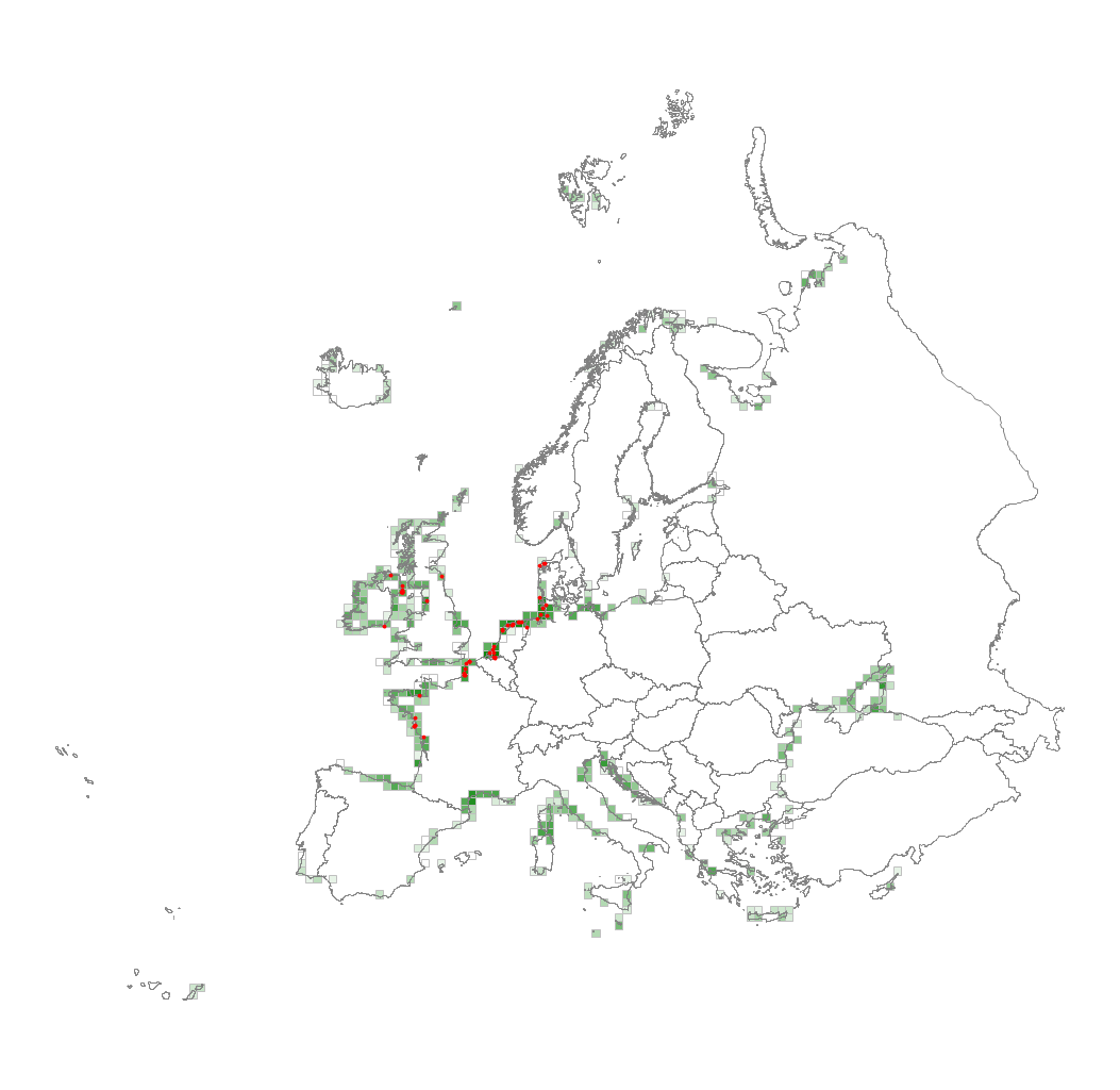
This metadata corresponds to the EUNIS Littoral biogenic habitat types (salt marshes), distribution based on vegetation plot data dataset. Littoral biogenic habitats (commonly known as salt marshes) are formed by animals such as worms and mussels or plants. The verified saltmarsh habitat samples used are derived from the Braun-Blanquet database (http://www.sci.muni.cz/botany/vegsci/braun_blanquet.php?lang=en) which is a centralised database of vegetation plots and comprises copies of national and regional databases using a unified taxonomic reference database. The geographic extent of the distribution data are all European countries except Armenia and Azerbaijan. The dataset is provided both in Geodatabase and Geopackage formats.
-
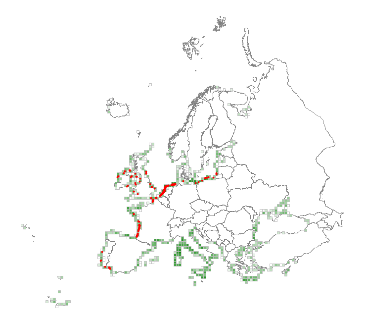
This metadata corresponds to the EUNIS Coastal habitat types, distribution based on vegetation plot data dataset. Coastal habitats are those above spring high tide limit (or above mean water level in non-tidal waters) occupying coastal features and characterised by their proximity to the sea, including coastal dunes and wooded coastal dunes, beaches and cliffs. Includes free-draining supralittoral habitats adjacent to marine habitats which are normally only very rarely subject to any type of salt water, in as much as they may be inhabited predominantly by terrestrial species, strandlines characterised by terrestrial invertebrates and moist and wet coastal dune slacks and dune-slack pools. Supralittoral sands and wracks may be found also in marine habitats (M). Excludes supralittoral rock pools and habitats, the splash zone immediately above the the mean water line, as well the spray zone and zone subject to sporadic inundation with salt water in as much as it may be inhabited predominantly by marine species, which are included in marine (M). The verified coastal habitat samples used are derived from the Braun-Blanquet database (http://www.sci.muni.cz/botany/vegsci/braun_blanquet.php?lang=en) which is a centralised database of vegetation plots and comprises copies of national and regional databases using a unified taxonomic reference database. The geographic extent of the distribution data are all European countries except Armenia and Azerbaijan. The dataset is provided both in Geodatabase and Geopackage formats.
-
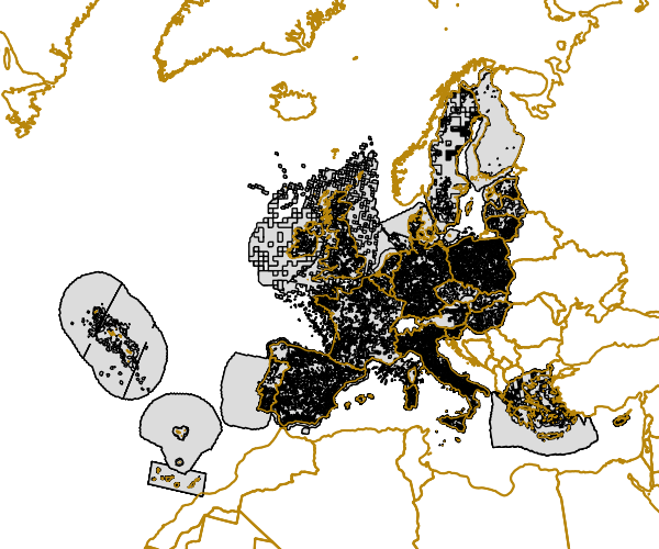
Gridded Distribution of Species as reported during the Article 17 of the Habitats Directive (92/43/EEC) covering the period 2001 to 2006. The data covers the EU 25. All Member States are requested by the Habitats Directive (92/43/EEC) to monitor habitat types and species considered to be of Community interest. Article 17 of the Habitats Directive 92/43/EEC requires that every 6 years Member States prepare reports to be sent to the European Commission on the implementation of the Directive. The Article 17 report for the period 2001-2006 for the first time includes assessments on the conservation status of the habitat types and species of Community interest. Information on the data quality of the 2001-2006 reporting round is available at http://bd.eionet.europa.eu/article17.
-
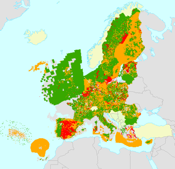
All Member States are requested by the Habitats Directive (92/43/EEC) to monitor habitat types and species listed in its annexes and send a report every 6 years following an agreed format. The assessment of conservation status is based on information about the status and trends of species populations and of habitats at the level of the biogeographical or marine region. The spatial dataset contains habitat and species distribution data (10km grid cells) as reported by EU 27 (2007-2013) Member States for the 2007-2012 period. This metadata refers to the public dataset, without sensitive species. The data sets are divided in two sets for species and two sets for habitat types. Habitats: Art17_habitats_distribution_2007_2012_EU (distribution by European Union aggregate) Art17_habitats_distribution_2007_2012_MS (distribution by Member State) Species: Art17_species_distribution_2007_2012_EU (distribution by European Union aggregate) Art17_species_distribution_2007_2012_MS (distribution by Member State) Furthermore, a series of tables are also provided with the assessments of conservation status of species and habitats at Member State biogeographical level (done by Member States) and at EU biogeographical level (done by the ETC/BD and the EEA). Both MS datasets are aggregated by habitat/species code, country and biogeographical /marine region [COMSRE]. Using this attribute [COMSRE] the tabular conservation status, which is available in the table, per biogeographical/marine region of the Member State level (MS) can be joined directly to the spatial dataset. Both EU datasets are aggregated by habitat/species code and biogeographical /marine region [CORE]. Using this attribute [CORE] the tabular conservation status, which is available in the table, of the biogeographical/marine region of the EU-27 (2007-2013) level (EU) can be directly joined to the spatial dataset. NOTE: The original datasets have been reviewed and re-published in February 2021, including delayed deliveries from Greece.
-
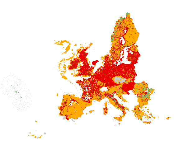
All Member States are requested by the Habitats Directive (92/43/EEC) to monitor habitat types and species listed in its annexes and send a report every 6 years following an agreed format. The assessment of conservation status is based on information about the status and trends of species populations and of habitats at the level of the biogeographical or marine region. The spatial dataset contains habitat and species distribution data (10km grid cells) as reported by Member States for the 2013-2018 period. This metadata refers to the public dataset, without sensitive species. The data sets are divided in two sets for species and two sets for habitat types. Species: ART17 species distribution MS (by Member State) ART17 species distribution EU (European Union aggregate) Habitats: ART17 habitats distribution MS (by Member State) ART17 habitats distribution EU (European Union aggregate) Both MS datasets are aggregated by habitat/species code, country and biogeographical /marine region [CO_MS_RE]. Using this attribute [CO_MS_RE] the tabular conservation status, which is available in the table, per biogeographical/marine region of the Member State level (MS) can be joined directly to the spatial dataset. Both EU datasets are aggregated by habitat/species code and biogeographical /marine region [CO_RE]. Using this attribute [CO_RE] the tabular conservation status, which is available in the table, of the biogeographical/marine region of the EU-28 level (EU) can be directly joined to the spatial dataset. Further description of the Article 17 tabular and spatial dataset and a Article 17 web tool can be accessed with the download data.
-
This dataset presents the estimated multiplication factor by which the frequency of flooding events of a given height in European tide gauges will change between 2010 and 2100, due to projected regional sea relative level rise under the Representative Concentration Pathways (RCP) 4.5 scenario. Values larger than 1 indicate an increase in flooding frequency. This dataset is derived from the Figure 13.25(b) of the Working Group I contribution to the IPCC Fifth Assessment Report (http://www.climatechange2013.org/images/report/WG1AR5_ALL_FINAL.pdf). This dataset also contributes to an earlier version of the EEA Indicator "Global and European sea-level": https://www.eea.europa.eu/data-and-maps/indicators/sea-level-rise-5/assessment.