 Catalogue PIGMA
habitat
Type of resources
Available actions
Topics
Keywords
Contact for the resource
Provided by
Years
Formats
Representation types
Update frequencies
status
Service types
Scale
Resolution
-
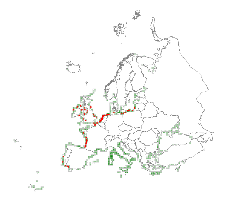
This metadata corresponds to the EUNIS Coastal habitat types, distribution based on vegetation plot data dataset. Coastal habitats are those above spring high tide limit (or above mean water level in non-tidal waters) occupying coastal features and characterised by their proximity to the sea, including coastal dunes and wooded coastal dunes, beaches and cliffs. Includes free-draining supralittoral habitats adjacent to marine habitats which are normally only very rarely subject to any type of salt water, in as much as they may be inhabited predominantly by terrestrial species, strandlines characterised by terrestrial invertebrates and moist and wet coastal dune slacks and dune-slack pools. Supralittoral sands and wracks may be found also in marine habitats (M). Excludes supralittoral rock pools and habitats, the splash zone immediately above the the mean water line, as well the spray zone and zone subject to sporadic inundation with salt water in as much as it may be inhabited predominantly by marine species, which are included in marine (M). The verified coastal habitat samples used are derived from the Braun-Blanquet database (http://www.sci.muni.cz/botany/vegsci/braun_blanquet.php?lang=en) which is a centralised database of vegetation plots and comprises copies of national and regional databases using a unified taxonomic reference database. The geographic extent of the distribution data are all European countries except Armenia and Azerbaijan. The dataset is provided both in Geodatabase and Geopackage formats.
-
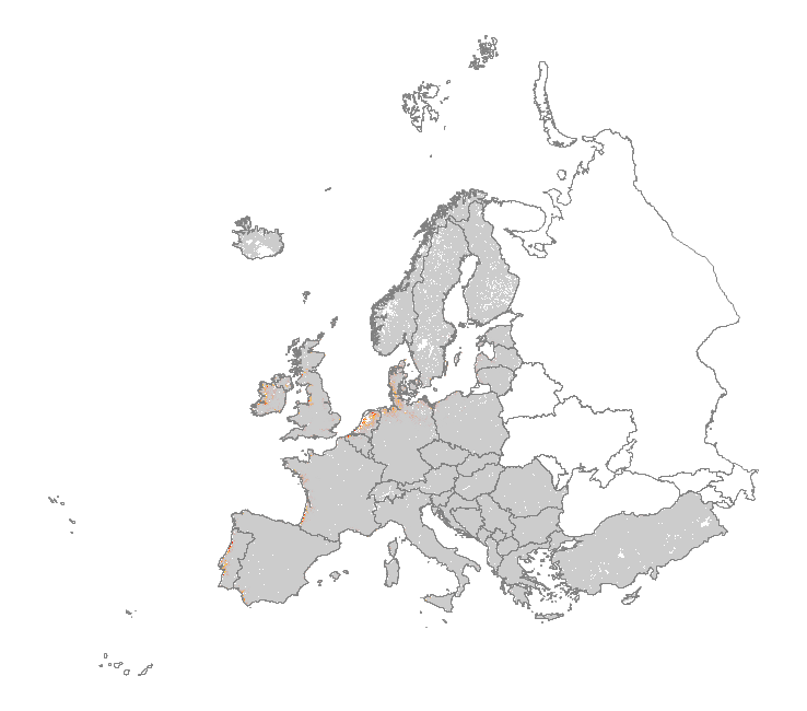
This metadata corresponds to the EUNIS Coastal habitat types, predicted distribution of habitat suitability dataset. Coastal habitats are those above spring high tide limit (or above mean water level in non-tidal waters) occupying coastal features and characterised by their proximity to the sea, including coastal dunes and wooded coastal dunes, beaches and cliffs. Includes free-draining supralittoral habitats adjacent to marine habitats which are normally only very rarely subject to any type of salt water, in as much as they may be inhabited predominantly by terrestrial species, strandlines characterised by terrestrial invertebrates and moist and wet coastal dune slacks and dune-slack pools. Supralittoral sands and wracks may be found also in marine habitats (M). Excludes supralittoral rock pools and habitats, the splash zone immediately above the the mean water line, as well the spray zone and zone subject to sporadic inundation with salt water in as much as it may be inhabited predominantly by marine species, which are included in marine (M). The modelled suitability for EUNIS coastal habitat types is an indication of where conditions are favourable for the habitat type based on sample plot data (Braun-Blanquet database) and the Maxent software package. The modelled suitability map may be used as a proxy for the geographical distribution of the habitat type. Note however that it is not representing the actual distribution of the habitat type. As predictors for the suitability modelling not only climate and soil parameters have been taken into account, but also so-called RS-EVB's, Remote Sensing-enabled Essential Biodiversity Variables, like land use, vegetation height, phenology, and LAI (Leaf Area Index). Because the EBV's are restricted by the extent of the remote sensing data (EEA38 countries and the United Kingdom) the modelling result does also not go beyond this boundary. The dataset is provided both in Geodatabase and Geopackage formats.
-
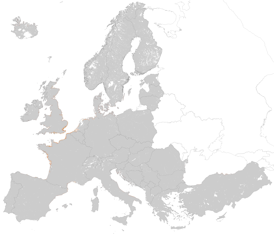
This metadata corresponds to the EUNIS Littoral biogenic habitat (salt marshes) types, predicted distribution of habitat suitability dataset. Littoral habitats are those formed by animals such as worms and mussels or plants (salt marshes). The verified littoral biogenic habitat samples used are derived from the Braun-Blanquet database (http://www.sci.muni.cz/botany/vegsci/braun_blanquet.php?lang=en) which is a centralised database of vegetation plots and comprises copies of national and regional databases using a unified taxonomic reference database. The geographic extent of the distribution data are all European countries except Armenia and Azerbaijan. The modelled suitability for EUNIS saltmarsh habitat types is an indication of where conditions are favourable for the habitat type based on sample plot data (Braun-Blanquet database) and the Maxent software package. The modelled suitability map may be used as a proxy for the geographical distribution of the habitat type. However, note that it is not representing the actual distribution of the habitat type. As predictors for the suitabilty modelling not only Climate and Soil parameters have been taken into account, but also so-called RS-EVB's, Remote Sensing-enabled Essential Biodiversity Variables like Landuse, Vegetation height, Phenology, LAI(Leave Area Index) and Population density. Because the EBV's are restricted by the extent of the Remote Sensing data (EEA38 countries and the United Kingdom) the modelling result does also not go beyond this boundary. The dataset is provided both in Geodatabase and Geopackage formats. The Training map files show the modelled suitable distribution, omitting the 10% of occurrence records in the least suitable environment under the assumption that they are not representative of the overall suitable habitat distribution. The 10 percentile training presence is an arbitrary threshold which omits all regions with habitat suitability lower than the suitability values for the lowest 10% of occurrence records.
-
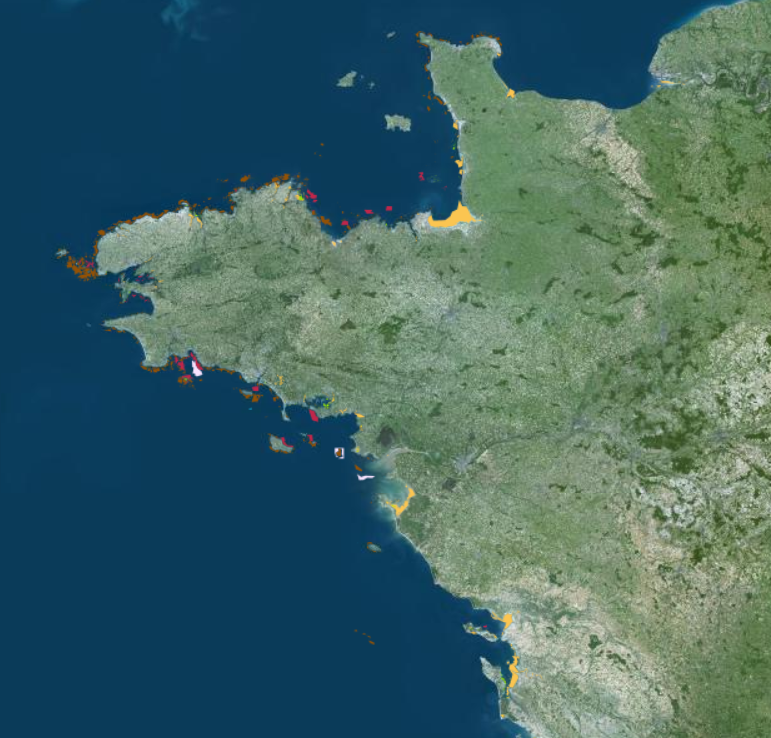
Cette cartographie d'habitats est issue de l'agrégation et de la synthèse d'inventaires des données d'habitats benthiques, réalisée par l'Office français de la biodiversité, dans le cadre du Life intégré Marha. Il s'agit d'une compilation des données open data multi sources et récentes de cartographies d'habitats benthiques et complétée par de nouvelles acquisitions de terrain (prélèvement par benne, drague, vidéo, sonar, bathymétrie). Elle regroupe des études cartographiques de divers maîtres d'ouvrage réalisées par un grand nombre d'auteurs et de programmes, à des échelles pouvant varier. Lors de l'intégration des données, les entités ont été fusionnées, simplifiées et lissées, de façon à alléger les fichiers volumineux pour optimiser l'affichage. Un travail d’harmonisation et de standardisation des données attributaires a été réalisé, ainsi que la correction des erreurs topologiques et la vérification de la cohérence thématique. Cette donnée met en évidence sous la forme de polygones les habitats intertidaux des typologies EUR27, CH2004, EUNIS et typologie nationale (spécifiés dans la couche source). Les couches sources utilisées sont : -Inventaires des données disponibles spatialisant les banquettes à haploops en France métropolitaine -Inventaire des données disponibles spatialisant les récifs d'hermelles en France métropolitaine -Inventaires des données disponibles spatialisant les forêts de laminaires en France métropolitaine -Inventaire 2022 d'herbiers de zostères en France métropolitaine -Inventaire des données disponibles spatialisant les bancs de maërl en France métropolitaine -Inventaire des données disponibles spatialisant les vasière intertidales en France métropolitaine Cette couche reflète un état des connaissances actuel des habitats marins, mais elle ne prétend pas à exhaustivité. Description de la table attributaire : id : Identifiant unique du polygone legende : Valeur pour une symbologie biocenose : Description de la biocénose présente dans la zone délimitée par le polygone surf_m2 : Surface en mètre carré (m²) du polygone calculée en lambert 93 source : Précise le nom de la source de la données d’origine (lien de métadonnées, lien ou titre de rapport, nom du programme de cartographie).
-
-
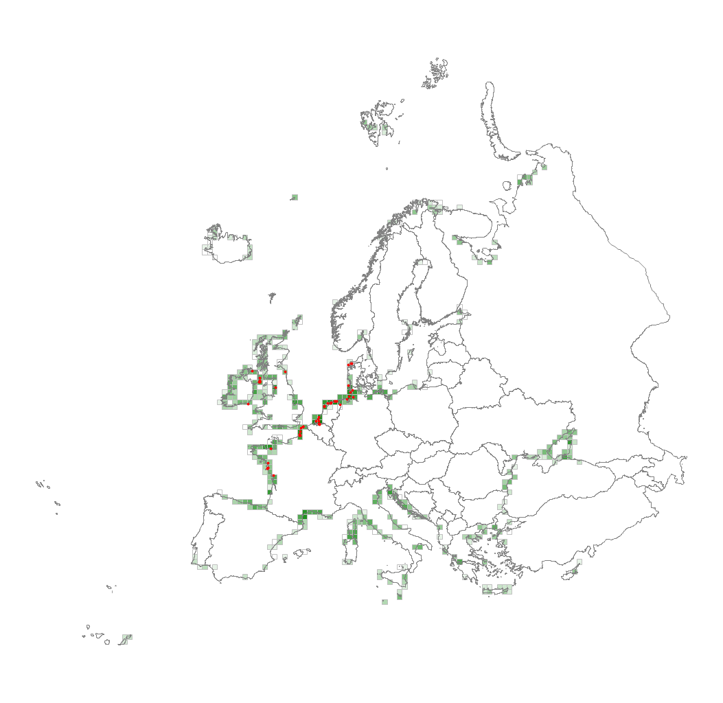
This metadata corresponds to the EUNIS Littoral biogenic habitat types (salt marshes), distribution based on vegetation plot data dataset. Littoral biogenic habitats (commonly known as salt marshes) are formed by animals such as worms and mussels or plants. The verified saltmarsh habitat samples used are derived from the Braun-Blanquet database (http://www.sci.muni.cz/botany/vegsci/braun_blanquet.php?lang=en) which is a centralised database of vegetation plots and comprises copies of national and regional databases using a unified taxonomic reference database. The geographic extent of the distribution data are all European countries except Armenia and Azerbaijan. The dataset is provided both in Geodatabase and Geopackage formats.
-
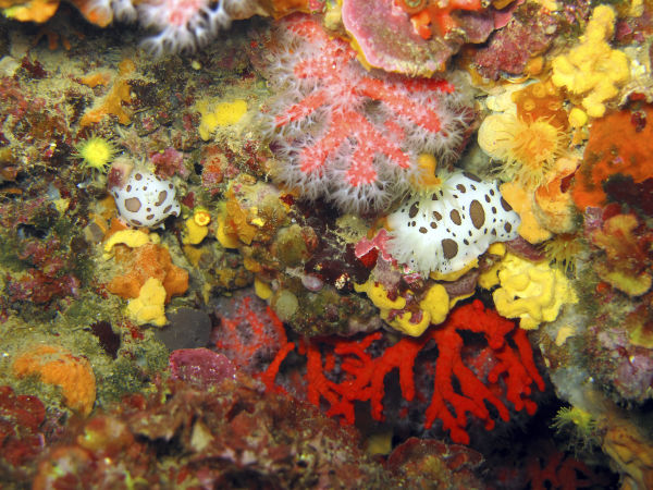
Cette compilation de données a pour objectif de spatialiser le coralligène en France métropolitaine. Initiée dans le cadre du Projet européen Life intégré Marha, il s'agit d' une compilation des données open data multi sources et récentes de cartographies d'habitats benthiques. Le Life Marha, qui a démarré le 01/11/2017 et prendra fin le 31/12/2025, est coordonné et mis en œuvre par l'Office français de la biodiversité (OFB) et par treize autres partenaires. Son objectif est de rétablir et maintenir le bon état de conservation des habitats naturels marins, tout en faisant progresser la mise en œuvre de la directive européenne « Habitats, Faune, Flore » en France métropolitaine et en mobilisant l’ensemble des acteurs impliqués dans la gestion des 162 sites Natura 2000 Habitats en mer. Pour atteindre cet objectif, Marha vise à : -diagnostiquer le fonctionnement et la mise en œuvre de Natura 2000 en mer, -évaluer l’état de conservation des habitats, leurs services écosystémiques et les usages et pressions qui s’y exercent ; -améliorer et compléter les outils à disposition des acteurs de la mise en œuvre de Natura 2000 en mer ; -appuyer les acteurs dans la mise en place d’actions concrètes en faveur de la préservation des habitats. Le Life Marha dispose d’un budget de 22,3 millions d’euros financés à hauteur de 60% par l'Union européenne dans le cadre du programme Life projets intégrés. Les 40% restant sont financés par les partenaires de Marha et par le ministère de la Transition écologique et solidaire. Cette donnée, au format polygone, a pour objectif de connaitre la répartition et les surfaces de l' habitat benthique. Elle est issue du Life Marha. Le filtre a été effectué sur l' ensemble des données recueillies (biocenose ilike '%corallig%' or code_eunis like '%A4.26%' or code_eunis like '%A4.32%' or code_mnhn like '%IV.3.1.%') nom de la donnée : eco_med_coralligene_ofb_pol_2154 Ce jeu de données est composé par les champs attributaires suivants : [id] : Identifiant unique du polygone. [biocenose] : Description de la biocénose présente dans la zone délimitée par le polygone. [code_ch] : Code de l'habitat élémentaire du cahier d'habitat 2004 - (En cas de mosaïque un ‘X’ est utilisé comme séparateur). [code_eunis] : Code d'habitat EUNIS - (En cas de mosaïque un ‘X’ est utilisé comme séparateur). [code_eur] : Code de l'habitat d’intérêt communautaire - (En cas de mosaïque un ‘X’ est utilisé comme séparateur). [code_mnhn] : Code d'habitat des typologies nationales Méditeranéenne ou Manche Atlantique - (En cas de mosaïque un ‘X’ est utilisé comme séparateur). [ifr] : Libellé de la typologie rebent (IFREMER) utilisée. http://www.rebent.org/fr/etudes-par-secteur/typologie-eunis/typologie-des-habitats-benthiques.php [comment_] : Commentaires divers. [date_supp] : Date du support de numérisation (jj/mm/aaaa). [date_val] : Date de validation sur le terrain (jj/mm/aaaa). [ech_num] : Échelle de numérisation ou taille-unité de l'unité minimale cartographiable. [hab_part] : Indique la présence d'un habitat particulier. [ic] : Indice de confiance du polygone (0 = non déterminé, 1 = qualification douteuse, 2 = qualification certaine mais limites incertaines, 3 = qualification certaine et limites certaines) . [method_num] : Méthode utilisée pour la numérisation et le support de numérisation des contours d’habitats, source et résolution s’il est précisé. [method_val] : Précise la méthode utilisée pour la validation. [auteur] : Prénom et nom de l’auteur du polygone. [org_aut] : Organisme de l’auteur du polygone. [validateur] : Prénom et nom du validateur du polygone. [org_val] : Organisme du validateur du polygone. [programme] : Nom du programme de cartographie. [rec_hab] : Pourcentage de recouvrement de l'habitat principal si mosaïque. [substrat] : Description de l’observation terrain concernant la nature du substrat. [surf_m2] : Surface du polygone en m². [validation] : Précise si le polygone a été validé par une vérification terrain, une analyse non automatisée. [zone] : Appellation terrain des zones du site (libre appréciation du prestataire). [legende] : Valeur pour une symbologie. [source] : Précise le nom de la source de la données d’origine (lien de métadonnées, lien ou titre de rapport, nom du programme de cartographie). [metadonnee] : lien de la métadonnée de la donnée originelle.
-
Plan local de l'habitat (PLH) de la Communauté d’Agglomération Côte Basque Adour. (métadonnée en cours)
-
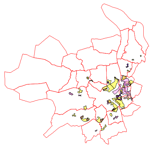
Ce jeu de données identifie par des surfaciques 4 types de données concernant la nouvelle géographie prioritaire définie par l'État : - Les quartiers prioritaires (QP) : initialement au nombre de 35, sont passés en 2014 au nombre de 21. Ils se situent sur 14 des 28 communes de Bordeaux Métropole et ont été retenus sur la base d'un critère économique (niveau de revenu très bas de ses habitants). - Les territoires de veille : ce sont des territoires qui ont été classés dans un premier temps « quartiers prioritaires » et qui ont été exclus de la nouvelle géographie prioritaire définie par l'État en 2014 et sur lesquels la Métropole a décidé de maintenir son action dans le cadre du contrat de ville en les identifiant en tant que « territoires de veille ». - Les zones franches urbaines (ZFU) ou territoires entrepreneurs, qui sont des quartiers situés dans des zones dites sensibles ou défavorisées. Ces zones ont été définies à partir de critères prenant en compte le taux de chômage, la proportion des jeunes de moins de 25 ans et de personnes sorties du système scolaire sans diplôme ainsi que du potentiel fiscal de la commune. Les entreprises implantées ou devant s'implanter dans ces quartiers bénéficient d'un dispositif complet d'exonérations de charges fiscales et sociales pendant quelques années et doivent en contrepartie réserver une partie de leurs embauches aux habitants de ces quartiers. - Les Nouveaux Programmes de Renouvellement Urbains (NPNRU) - quartiers porteurs d'un projet de renouvellement urbain dans le cadre de l'ANRU (Agence Nationale pour la Rénovation Urbaine) Ces quartiers bénéficient de financements spécifiques permettant de soutenir et de développer leur attractivité (développement économique, création d'équipements publics, diversification de l'offre de logements, amélioration de la mobilité) Ces périmètres, et les interventions qui pourront y être menées, ont été inscrits dans un protocole de préfiguration signé le 12 juillet 2017 entre l'État, l'ANRU, les communes, les bailleurs concernés, la Métropole et les différents partenaires. Ces NPNRU ont été classifiés suivant 3 niveaux d'intervention : Opération d'intérêt national (OIN), Opération d'intérêt régional (OIR1), Opération d'intérêt local (OIR2).
-

Zonage composé de l'ensemble des périmètres de programme local de l'habitat (PLH) - Un PLH définit la politique de l'habitat sur un territoire intercommunal. Il vise à répondre aux besoins en logements (social ou non, locatif ou non), à favoriser la mixité sociale en assurant une répartition équilibrée et diversifiée de l'offre en logements au sein d'un territoire intercommunal et indique les moyens pour y parvenir. Sa procédure spécifique implique qu'il n'est porté que par un EPCI ayant la compétence PLH en association avec l'Etat. Un programme local de l'habitat dure généralement six ans. La loi Molle du 29 mars 2009 modifie la portée du PLH en le rendant beaucoup plus opérationnel et oblige les EPCI à détailler les objectifs à la commune. Le programme engage l'Etat, les communes, les intercommunalités et le cas échéant les conseils généraux délégataires des aides à la pierre. Les actions sont mises en oeuvre par les opérateurs : organismes de logement social, opérateurs professionnels privés, propriétaires occupants ou bailleurs. Ces données ne contiennent que les PLH en cours d'élaboration ou en vigueur, les anciens PLH (c'est à dire ceux qui sont terminés) étant archivés à un état annulé.