 Catalogue PIGMA
0.02 degree
Type of resources
Available actions
Topics
Keywords
Contact for the resource
Provided by
Years
Formats
Representation types
Update frequencies
status
Resolution
-
The Joint Polar Satellite System (JPSS), starting with S-NPP launched on 28 October 2011, is the new generation of the US Polar Operational Environmental Satellites (POES). The ACSPO SNPP/VIIRS L3U (Level 3 Uncollated) product is a gridded version of the ACSPO NPP/VIIRS L2P product available here https://doi.org/10.5067/GHVRS-2PO28 . The L3U output files are 10-minute granules in netCDF4 format, compliant with the Group for High Resolution Sea Surface Temperature (GHRSST) Data Specification version 2 (GDS2). There are 144 granules per 24hr interval, with a total data volume of 0.5GB/day. Fill values are reported at all invalid pixels, including pixels with >5 km inland. For each valid water pixel (defined as ocean, sea, lake or river, and up to 5 km inland), the following layers are reported: SSTs, a subset of l2p_flags (including day/night, land, ice, twilight, and glint flags), wind speed, and ACSPO SST minus reference (Canadian Met Centre 0.1deg L4 SST; available at https://www.doi.org/10.5067/GHCMC-4FM03). Only L2P SSTs with QL=5 were gridded, so all valid SSTs are recommended for the users. Per GDS2 specifications, two additional Sensor-Specific Error Statistics layers (SSES bias and standard deviation) are reported in each pixel with valid SST. The ACSPO VIIRS SST products are monitored and validated against in situ data in the NOAA iQuam system (https://www.star.nesdis.noaa.gov/socd/sst/iquam ) using the NOAA SQUAM system (https://www.star.nesdis.noaa.gov/socd/sst/squam ). BTs are monitored against RTM simulation in MICROS (https://www.star.nesdis.noaa.gov/socd/sst/micros ). Quality of SST imagery and clear-sky mask are evaluated in the NOAA ARMS system (https://www.star.nesdis.noaa.gov/socd/sst/arms ). The v2.80 is an updated version from the v2.61 with several L2P algorithm improvements including two added thermal front layers, mitigated warm biases in the high latitudes, and improved clear-sky mask.
-
NOAA produces two lines of gridded 0.02deg super-collated L3S LEO SST datasets from Low Earth Orbiting (LEO) satellites, one from the NOAA afternoon JPSS (L3S_LEO_PM) and the other from the EUMETSAT mid-morning Metop-FG (L3S_LEO_AM). The L3S_LEO_AM is derived from Metop-A, -B and -C. The Metop-FG satellite program was jointly established by ESA and EUMETSAT. The US NOAA, under the Initial Joint Polar System Agreement with EUMETSAT, has contributed three AVHRR sensors capable of collecting and transmitting data in the Full Resolution Area Coverage (FRAC; 1km/nadir) format. The L3S_LEO_AM dataset is produced by aggregating three L3U datasets from MetOp-FG satellites ( http://doi.org/10.5067/GHMTA-3US28 , http://doi.org/10.5067/GHMTB-3US28 , http://doi.org/10.5067/GHMTC-3US28 ) and covers from Dec 2006-present. The L3S-LEO-AM data are reported in two files per 24hr interval, one daytime and one nighttime (nominal Metop local equator crossing times around 09:30/21:30, respectively), in NetCDF4 format, compliant with the GHRSST Data Specification version 2 (GDS2). The Near-Real Time (NRT) L3S-LEO data are archived at PO.DAAC with approximately 6 hours latency and then replaced by the Delayed Mode files about 2 months later, with identical file names. The NRT/DM data are seamlessly stitched with the full-mission Reanalysis (RAN). In addition to SST, the L3S-LEO files report the location and intensity of thermal fronts. The ACSPO L3S products are monitored and validated against in situ data in the NOAA iQuam system ( https://www.star.nesdis.noaa.gov/socd/sst/iquam ) in the NOAA SQUAM system ( https://www.star.nesdis.noaa.gov/socd/sst/squam ). Quality of SST imagery and clear-sky mask is evaluated in the NOAA ARMS system ( https://www.star.nesdis.noaa.gov/socd/sst/arms ). NOAA plans to include data from other mid-morning platforms and sensors, such as Metop-SG METImage, into L3S_LEO_AM.
-
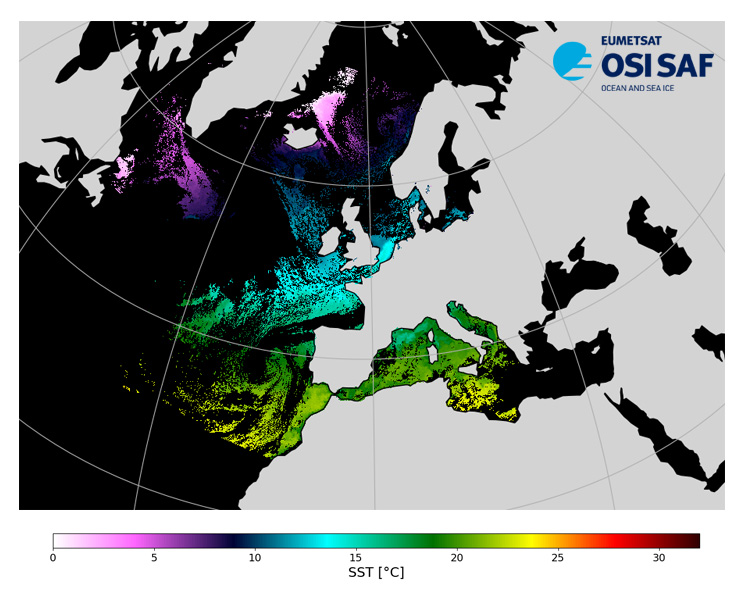
Level 3, four times a day, sub-skin Sea Surface Temperature derived from AVHRR on Metop satellites and VIIRS or AVHRR on NOAA and NPP satellites, over North Atlantic and European Seas and re-projected on a polar stereographic at 2 km resolution, in GHRSST compliant netCDF format. This catalogue entry presents NOAA-20 North Atlantic Regional Sea Surface Temperature. SST is retrieved from infrared channels using a multispectral algorithm and a cloud mask. Atmospheric profiles of water vapor and temperature from a numerical weather prediction model, Sea Surface Temperature from an analysis, together with a radiative transfer model, are used to correct the multispectral algorithm for regional and seasonal biases due to changing atmospheric conditions. The quality of the products is monitored regularly by daily comparison of the satellite estimates against buoy measurements. The product format is compliant with the GHRSST Data Specification (GDS) version 2.Users are advised to use data only with quality levels 3,4 and 5.
-
This L3U (Level 3 Uncollated) dataset contains global daily Sea Surface Temperature (SST) on a 0.02 degree grid resolution. It is produced by the National Oceanic and Atmospheric Administration (NOAA) Advanced Clear Sky Processor for Ocean (ACSPO) using L2P (Level 2 Preprocessed) product acquired from the Meteorological Operational satellite A (Metop-A) Advanced Very High Resolution Radiometer 3 (AVHRR/3) (https://podaac.jpl.nasa.gov/dataset/AVHRRF_MA-STAR-L2P-v2.80 ) in Full Resolution Area Coverage (FRAC) mode as input. It is distributed as 10-minute granules in netCDF-4 format, compliant with the Group for High Resolution Sea Surface Temperature (GHRSST) Data Specification version 2 (GDS2). There are 144 granules per 24-hour interval. Fill values are reported in all invalid pixels, including land pixels with >5 km inland. For each valid water pixel (defined as ocean, sea, lake or river), and up to 5 km inland, the following major layers are reported: SSTs and ACSPO clear-sky mask (ACSM; provided in each grid as part of l2p_flags, which also includes day/night, land, ice, twilight, and glint flags). Only input L2P SSTs with QL=5 were gridded, so all valid SSTs are recommended for the users. Per GDS2 specifications, two additional Sensor-Specific Error Statistics layers (SSES bias and standard deviation) are reported in each pixel with valid SST. Ancillary layers include wind speed and ACSPO minus reference Canadian Meteorological Centre (CMC) Level 4 (L4) SST. The ACSPO Metop-A AVHRR FRAC L3U product is monitored and validated against iQuam in situ data https://www.star.nesdis.noaa.gov/socd/sst/iquam , in the NOAA SST Quality Monitor (SQUAM) system https://www.star.nesdis.noaa.gov/socd/sst/squam . SST imagery and clear-sky mask are evaluated, and checked for consistency with L2P and other satellites/sensors SST products, in the NOAA ACSPO Regional Monitor for SST (ARMS) system https://www.star.nesdis.noaa.gov/socd/sst/arms . More information about the dataset is found at AVHRRF_MA-STAR-L2P-v2.80 and in (Pryamitsyn et al., 2021).
-
This L3U (Level 3 Uncollated) dataset contains global daily Sea Surface Temperature (SST) on a 0.02 degree grid resolution. It is produced by the National Oceanic and Atmospheric Administration (NOAA) Advanced Clear Sky Processor for Ocean (ACSPO) using L2P (Level 2 Preprocessed) product acquired from the Meteorological Operational satellite C (Metop-C) Advanced Very High Resolution Radiometer 3 (AVHRR/3) (https://podaac.jpl.nasa.gov/dataset/AVHRRF_MC-STAR-L2P-v2.80 ) in Full Resolution Area Coverage (FRAC) mode as input. It is distributed as 10-minute granules in netCDF-4 format, compliant with the Group for High Resolution Sea Surface Temperature (GHRSST) Data Specification version 2 (GDS2). There are 144 granules per 24-hour interval. Fill values are reported in all invalid pixels, including land pixels with >5 km inland. For each valid water pixel (defined as ocean, sea, lake or river), and up to 5 km inland, the following major layers are reported: SSTs and ACSPO clear-sky mask (ACSM; provided in each grid as part of l2p_flags, which also includes day/night, land, ice, twilight, and glint flags). Only input L2P SSTs with QL=5 were gridded, so all valid SSTs are recommended for the users. Per GDS2 specifications, two additional Sensor-Specific Error Statistics layers (SSES bias and standard deviation) are reported in each pixel with valid SST. Ancillary layers include wind speed and ACSPO minus reference Canadian Meteorological Centre (CMC) Level 4 (L4) SST. The ACSPO Metop-C AVHRR FRAC L3U product is monitored and validated against iQuam in situ data https://www.star.nesdis.noaa.gov/socd/sst/iquam in the NOAA SST Quality Monitor (SQUAM) system https://www.star.nesdis.noaa.gov/socd/sst/squam . SST imagery and clear-sky mask are evaluated, and checked for consistency with L2P and other satellites/sensors SST products, in the NOAA ACSPO Regional Monitor for SST (ARMS) system https://www.star.nesdis.noaa.gov/socd/sst/arms . More information about the dataset is found at AVHRRF_MC-STAR-L2P-v2.80 and in (Pryamitsyn et al., 2021).
-
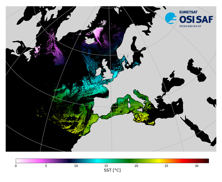
Level 3, four times a day, sub-skin Sea Surface Temperature derived from AVHRR on Metop satellites and VIIRS or AVHRR on NOAA and NPP satellites, over North Atlantic and European Seas and re-projected on a polar stereographic at 2 km resolution, in GHRSST compliant netCDF format. This catalogue entry presents Metop-B North Atlantic Regional Sea Surface Temperature. SST is retrieved from infrared channels using a multispectral algorithm and a cloud mask. Atmospheric profiles of water vapor and temperature from a numerical weather prediction model, Sea Surface Temperature from an analysis, together with a radiative transfer model, are used to correct the multispectral algorithm for regional and seasonal biases due to changing atmospheric conditions. The quality of the products is monitored regularly by daily comparison of the satellite estimates against buoy measurements. The product format is compliant with the GHRSST Data Specification (GDS) version 2.Users are advised to use data only with quality levels 3,4 and 5.
-
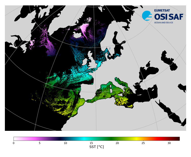
Level 3, four times a day, sub-skin Sea Surface Temperature derived from AVHRR on Metop satellites and VIIRS or AVHRR on NOAA and NPP satellites, over North Atlantic and European Seas and re-projected on a polar stereographic at 2 km resolution, in GHRSST compliant netCDF format. This catalogue entry presents NOAA-18 North Atlantic Regional Sea Surface Temperature. SST is retrieved from infrared channels using a multispectral algorithm and a cloud mask. Atmospheric profiles of water vapor and temperature from a numerical weather prediction model, Sea Surface Temperature from an analysis, together with a radiative transfer model, are used to correct the multispectral algorithm for regional and seasonal biases due to changing atmospheric conditions. The quality of the products is monitored regularly by daily comparison of the satellite estimates against buoy measurements. The product format is compliant with the GHRSST Data Specification (GDS) version 2.Users are advised to use data only with quality levels 3,4 and 5.
-
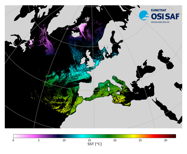
Level 3, four times a day, sub-skin Sea Surface Temperature derived from AVHRR on Metop satellites and VIIRS or AVHRR on NOAA and NPP satellites, over North Atlantic and European Seas and re-projected on a polar stereographic at 2 km resolution, in GHRSST compliant netCDF format. This catalogue entry presents Metop-A North Atlantic Regional Sea Surface Temperature. SST is retrieved from infrared channels using a multispectral algorithm and a cloud mask. Atmospheric profiles of water vapor and temperature from a numerical weather prediction model, Sea Surface Temperature from an analysis, together with a radiative transfer model, are used to correct the multispectral algorithm for regional and seasonal biases due to changing atmospheric conditions. The quality of the products is monitored regularly by daily comparison of the satellite estimates against buoy measurements. The product format is compliant with the GHRSST Data Specification (GDS) version 2.Users are advised to use data only with quality levels 3,4 and 5.
-
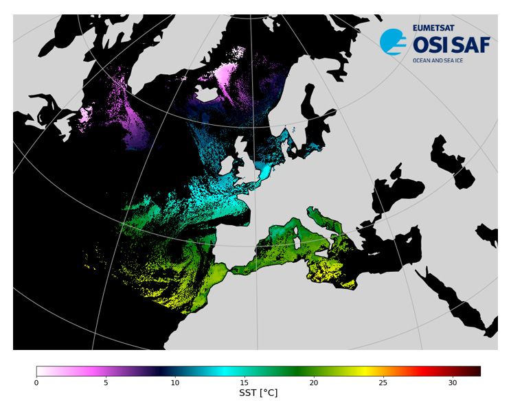
Level 3, four times a day, sub-skin Sea Surface Temperature derived from AVHRR on Metop satellites and VIIRS or AVHRR on NOAA and NPP satellites, over North Atlantic and European Seas and re-projected on a polar stereographic at 2 km resolution, in GHRSST compliant netCDF format. This catalogue entry presents NOAA-19 North Atlantic Regional Sea Surface Temperature. SST is retrieved from infrared channels using a multispectral algorithm and a cloud mask. Atmospheric profiles of water vapor and temperature from a numerical weather prediction model, Sea Surface Temperature from an analysis, together with a radiative transfer model, are used to correct the multispectral algorithm for regional and seasonal biases due to changing atmospheric conditions. The quality of the products is monitored regularly by daily comparison of the satellite estimates against buoy measurements. The product format is compliant with the GHRSST Data Specification (GDS) version 2.Users are advised to use data only with quality levels 3,4 and 5.
-
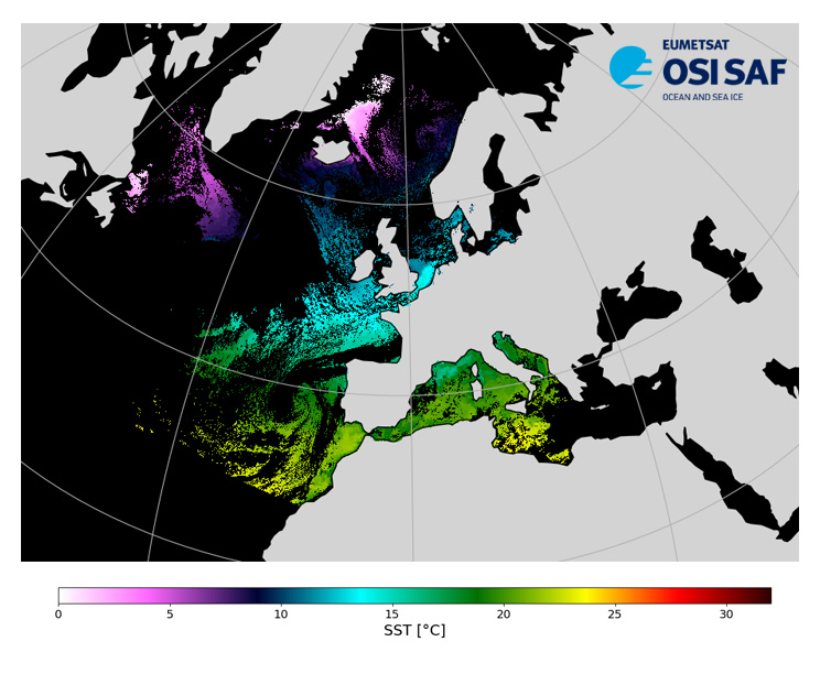
Level 3, four times a day, sub-skin Sea Surface Temperature derived from AVHRR on Metop satellites and VIIRS or AVHRR on NOAA and NPP satellites, over North Atlantic and European Seas and re-projected on a polar stereographic at 2 km resolution, in GHRSST compliant netCDF format. This catalogue entry presents Suomi-NPP North Atlantic Regional Sea Surface Temperature. SST is retrieved from infrared channels using a multispectral algorithm and a cloud mask. Atmospheric profiles of water vapor and temperature from a numerical weather prediction model, Sea Surface Temperature from an analysis, together with a radiative transfer model, are used to correct the multispectral algorithm for regional and seasonal biases due to changing atmospheric conditions. The quality of the products is monitored regularly by daily comparison of the satellite estimates against buoy measurements. The product format is compliant with the GHRSST Data Specification (GDS) version 2.Users are advised to use data only with quality levels 3,4 and 5.