 Catalogue PIGMA
initiative
Type of resources
Available actions
Topics
Keywords
Contact for the resource
Provided by
Years
Formats
Representation types
status
-

Businesses, policymakers, and local communities need to access reliable weather and climate information to safeguard human health, wellbeing, economic growth, and environmental sustainability. However, important changes in climate variability and extreme weather events are difficult to pinpoint and account for in existing modelling and forecasting tools. Moreover, many changes in the global climate are linked to the Arctic, where climate change is occurring rapidly, making weather and climate prediction a considerable challenge. Blue-Action evaluated the impact of Arctic warming on the northern hemisphere and developed new techniques to improve forecast accuracy at sub-seasonal to decadal scales. Blue-Action specifically worked to understand and simulate the linkages between the Arctic and the global climate system, and the Arctic’s role in generating weather patterns associated with hazardous conditions and climatic extremes. In doing so, Blue-Action aimed to improve the safety and wellbeing of people in the Arctic and across the Northern Hemisphere, reduce the risks associated with Arctic operations and resource exploitation, and support evidence-based decision-making by policymakers worldwide.
-
The Continuous Plankton Recorder (CPR) Survey is the most geographically extensive marine monitoring programme in the world. Today the Survey is operated by the Marine Biological Association, based in Plymouth, UK. Operating since 1931, the Continuous Plankton Recorder (CPR) survey is recognised as the longest sustained and geographically most extensive marine biological survey in the world. The dataset comprises a uniquely large record of marine biodiversity covering ~800 taxa over multi-decadal periods. In terms of our scientific understanding of natural variability and human-induced change on our oceans, the CPR survey is of global importance and it is used by scientists, policy makers and environmental managers across the world. The data is used to examine strategically important science pillars such as climate change, human health, fisheries, biodiversity, pathogens, invasive species, ocean acidification and natural capital. The results have included the globally first documented studies of large-scale ecological regime shifts, and of biogeographic, phenological and trans-arctic migrations in the marine environment in response to climate change. The data in this sampling event resource has been published as a Darwin Core Archive (DwC-A), which is a standardized format for sharing biodiversity data as a set of one or more data tables. The core data table contains 252,385 records. 2 extension data tables also exist. An extension record supplies extra information about a core record. The number of records in each extension data table is illustrated below.
-
The All-Atlantic Ocean Research and Innovation Alliance (AAORIA) is the result of science diplomacy efforts involving countries from both sides of the Atlantic Ocean. It builds upon the success of two existing cooperative agreements – the Galway Statement on Atlantic Ocean Cooperation which was signed by the European Union, United States, and Canada in 2013; and the Belem Statement on Atlantic Ocean Research and Innovation Cooperation which was signed by the European Union, Brazil, and South Africa in 2017 as well as on several other bilateral and multilateral agreements. AAORIA aims to enhance marine research and innovation cooperation along and across the Atlantic Ocean. In 2022, the “All-Atlantic Declaration” was signed to revitalize collaboration among current initiatives and enhance the coordination between the Galway Working Groups, All-Atlantic Joint Pilot Actions, and related projects. Additionally, it aims to engage new partners and initiatives to join the All-Atlantic community.
-
The CWP, supported by the participating organizations, serves as the premier international and interorganizational forum for agreeing common definitions, classifications and standards for the collection of fishery and aquaculture statistics. It has developed common procedures for statistics collation which have streamlined processes and reduced the burden on the statistical offices of national fisheries and aquaculture production, as well as providing technical advice to participating organizations on fishery-related and aquaculture-related statistical matters, and facilitating the publication of methodological and reference documents. The Coordinating Working Party on Fishery Statistics (CWP) provides a mechanism to coordinate the statistical programmes conducted by regional fishery bodies and other intergovernmental organizations with a remit for fishery statistics. Main function: - To continually review fishery statistics requirements for research, policy-making and management; - To agree on standard concepts, definitions, classifications and methodologies for the collection and collation of fishery statistics; - To submit proposals for the coordination and streamlining of statistical activities among the relevant intergovernmental organizations.
-
The indiSeaS project is co-funded by the Intergovernmental Oceanographic Commission (IOC), the European Network of Excellence Euroceans, “'Institut de recherche pour le développement (IRD)” and the European project on Marine Ecosystem Evolution in a Changing Environment (MEECE). It is a multi-institutes collaborative effort. Scientific experts on ecosystems all over world calculate indicators and provide background information. The IndiSeas project aims at "Evaluating the status of marine ecosystems in a changing world”, using a set of different types of indicators to reflect the effects of multiple drivers on the states and trends of marine exploited ecosystems. It focuses on the effects of fishing, use of ecology, biodiversity, as well as climate and socio-economic indicators on world's marine ecosystems health. The objectives are to review IndiSeas datasets, present preliminary results to regional experts, discuss methods to be developed in each of the six task groups, establish work and publication plans for the future. Expertise from over 70 scientists, 49 research institutes and 36 countries.
-
The International Whaling Commission was set up under the International Convention for the Regulation of Whaling which was signed in Washington DC on 2nd December 1946. The preamble to the Convention states that its purpose is to provide for the proper conservation of whale stocks and thus make possible the orderly development of the whaling industry. The Commission undertakes extensive study and research on cetacean populations, develops and maintains scientific databases, and publishes its own peer reviewed scientific journal, the Journal of Cetacean Research and Management. A list of catches since the moratorium came into place (in the 1985/6 Antarctic Season) up to 2019 (download link).
-

The International Commission for the Conservation of Atlantic Tunas is an inter-governmental fishery organization responsible for the conservation of tunas and tuna-like species in the Atlantic Ocean and its adjacent seas. ICCAT compiles fishery statistics from its members and from all entities fishing for these species in the Atlantic Ocean, coordinates research, including stock assessment, on behalf of its members, develops scientific-based management advice, provides a mechanism for Contracting Parties to agree on management measures, and produces relevant publications. Science underpins the management decisions made by ICCAT. Much of the information available on this site relates to scientific data, reports of scientific meetings and to scientific articles.
-
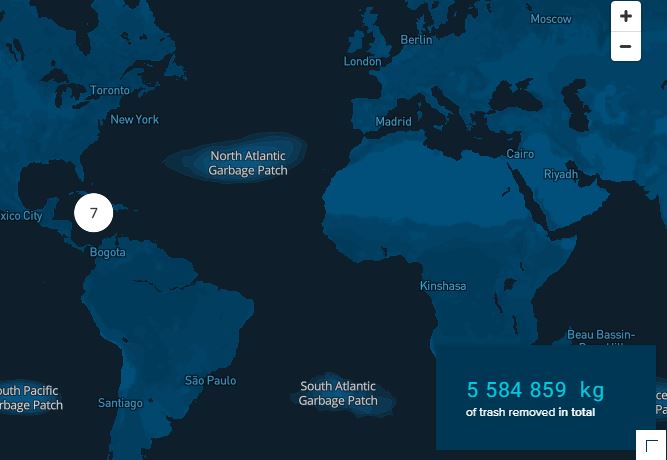
Every year, millions of tons of plastic enter the oceans, of which the majority spills out from rivers. A portion of this plastic travels to ocean garbage patches, where it gets caught in a vortex of circulating currents alongside plastic from other sources (e.g. offshore fishing activities). If no action is taken, plastic will increasingly impact our ecosystems, health, and economies. The Ocean Cleanup is a non-profit organization developing and scaling technologies to rid the oceans of plastic. To achieve this objective, we have to work on a combination of closing the sources of plastic pollution and cleaning up what has already accumulated in the ocean and doesn’t go away by itself. This goal means we plan to put ourselves out of business – once we have completed this project, our work is done. To rid the oceans of plastic, we need not only to clean up what is already out there but also stop new plastic from entering the ocean – we need to close the tap. Working together with government leaders, individuals, and private corporations, our goal is to tackle these 1000 most polluting rivers all over the world Every single year, marine plastic costs the economy (6 to 19) billions of dollars – impacting tourism, fisheries and aquaculture, and (governmental) cleanups. And that doesn’t include the impact on our health and on the marine ecosystem. Intercepting plastic in rivers is much more cost-effective than dealing with the consequences downstream.
-
The North East Atlantic Fisheries Commission (NEAFC) is the Regional Fisheries Management Organisation (RFMO) for the North East Atlantic, one of the most abundant fishing areas in the world. It is comprised of Contracting Parties which have signed up to the Convention on Multilateral Cooperation in North East Atlantic Fisheries, which entered into force in November 1982. The area covered by the NEAFC Convention stretches from the southern tip of Greenland, east to the Barents Sea, and south to Portugal. Most of the information on this website is aimed at scientists, control experts, statisticians and managers from the Contracting Parties and other international organisations. The objective of NEAFC is to ensure the long-term conservation and optimum utilisation of the fishery resources in its Convention Area, providing sustainable economic, environmental and social benefits.
-
The vision of the AtlantOS project was to improve and innovate Atlantic observing by using the Framework of Ocean Observing to obtain an international, more sustainable, more efficient, more integrated, and fit-for-purpose system contributing to the Trans-Atlantic Research Alliance, the GEO (Group on Earth Observations) global initiative Blue Planet, and GOOS (Global Ocean Observing Systems). Hence, the AtlantOS project will have a long-lasting and sustainable contribution to the societal, economic and scientific benefit arising from this integrated approach. This will be achieved by improving the value for money, extent, completeness, quality and ease of access to Atlantic Ocean data required by industries, product supplying agencies, scientists and citizens. The overarching target of the AtlantOS initiative was to deliver an advanced framework for the development of an integrated Atlantic Ocean Observing System that goes beyond the state-of–the-art, and leaves a legacy of sustainability after the life of the project (see AtlantOS High-Level Strategy and find out more about the AtlantOS program). The legacy derived from the AtlantOS aims: - to improve international collaboration in the design, implementation and benefit sharing of ocean observing, - to promote engagement and innovation in all aspects of ocean observing, - to facilitate free and open access to ocean data and information, - to enable and disseminate methods of achieving quality and authority of ocean information, - to strengthen the Global Ocean Observing System (GOOS) and to sustain observing systems that are critical for the Copernicus Marine Environment Monitoring Service and its applications and - to contribute to the aims of the Galway Statement on Atlantic Ocean Cooperation The project was organized along work packages on: i) observing system requirements and design studies, ii) enhancement of ship-based and autonomous observing networks, iii) interfaces with coastal ocean observing systems, iv) integration of regional observing systems, v) cross-cutting issues and emerging networks, vi) data flow and data integration, vii) societal benefits from observing /information systems, viii) system evaluation and resource sustainability. Engagement with wider stakeholders including end-users of Atlantic Ocean observation products and services was also key throughout the project. The AtlantOS initiative contributed to achieving the aims of the Galway Statement on Atlantic Ocean Cooperation that was signed in 2013 by the EU, Canada and the US, launching a Transatlantic Ocean Research Alliance to enhance collaboration to better understand the Atlantic Ocean and sustainably manage and use its resources.