2007
Type of resources
Available actions
Topics
Keywords
Contact for the resource
Provided by
Years
Formats
Representation types
Update frequencies
status
Scale
Resolution
-
Explore global fisheries and aquaculture. Understand their status and how impacts are being managed. Learn what improvements are underway, and see what actions seafood stakeholders can take to drive sustainability. FishSource is a publicly available online resource about the status of fisheries, fish stocks, and aquaculture. FishSource compiles and summarizes publicly available scientific and technical information and presents it in an easily interpretable form. FishSource was created in 2007 by Sustainable Fisheries Partnership to provide major seafood buyers with up-to-date, impartial, and actionable information on the sustainability of fisheries and the improvements they need to make to become more sustainable. In 2018, information on aquaculture sources was added to the database to provide FishSource users with a more robust tool that covers all types of seafood production. Although the primary intended audience of FishSource is seafood businesses, other audiences - such as academics, researchers, and non-profit organizations - have also become frequent and welcomed users of FishSource. The information on FishSource is primarily developed and updated by a small team of in-house analysts, but their capacity is recognizably insufficient to maintain complete coverage of all global fisheries. As such, profiles may be incomplete or information may be out of date. The seafood industry and external contributors are invited to help fill any gaps that they consider priorities through our Rapid Assessment Program. FishSource always welcome comments on any of our profiles and encourage an open debate on the sources of information used and our interpretation of the data. Our objective is to use only publicly available sources and fully credit those sources, effectively acting as an inventory of information sources on fisheries and aquaculture.
-
Auteur(s): Buron Anne , Projet d'un équipement culturel dans les îlots des écluses 'Lesieur Céréol' et de l'îlot 'Tête de pont' dans le secteur des bassins à flots de Bordeaux.
-
Auteur(s): Barot Faustine , Comment penser la ville dans sa globalité, concilier urbanité et mobilité, articuler les infrastructure avec le bâti, pour donner une cohérence à l'ensemble ? Telles sont les questions auxquelles l'auteur tente de répondre par une étude et un projet sur le quartier de Bacalan à Bordeaux, au niveau du futur pont sur la Garonne.
-
Auteur(s): Durand Virginie , Ce TPFE propose une réflexion sur le logement étudiant, une analyse des besoins en la matière à Bordeaux, et un projet de cité universitaire internationale dans le quartier de la Bastide.
-
Auteur(s): Delanne Hubert-Alexandre , Dans une première partie, l'auteur témoigne de sa sensibilité à la question du développement durable et à ses incidences dans le domaine de l'architecture, par l'intermédiaire de la norme HQE (Haute Qualité Environnementale). Dans cette perspective, il développe, ensuite, une analyse critique de l'évolution du logement social en France, et présente l'idée d'habitat intermédiaire, comme solution de compromis entre les aspirations individualistes d'une part, et la nécessité de lutter contre l'étalement urbain, d'autre part. Le quartier Vigon, à Mimizan (Landes), lui semble propice à une expérimentation de cette forme d'habitat, dans le souci de s'adapter à la diversité des modes de vie de ses occupants, tout en préservant une densité urbaine suffisante et en intégrant, dans la construction, les principes de la HQE.
-
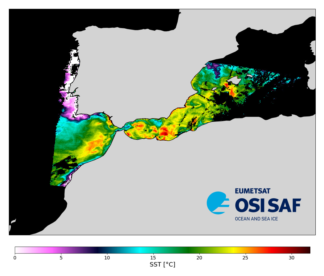
Level 2 sub-skin Sea Surface Temperature derived from AVHRR on Metop, global and provided in full-resolution swath (1 km at nadir), in GHRSST compliant netCDF format. The satellite input data has successively come from Metop-A, Metop-B and Metop-C level 1 data processed at EUMETSAT. SST is retrieved from AVHRR infrared channels (3.7, 10.8 and 12.0 µm) using a multispectral algorithm and a cloud mask. Atmospheric profiles of water vapor and temperature from a numerical weather prediction model, Sea Surface Temperature from an analysis, together with a radiative transfer model, are used to correct the multispectral algorithm for regional and seasonal biases due to changing atmospheric conditions. The quality of the products is monitored regularly by daily comparison of the satellite estimates against buoy measurements.The product format is compliant with the GHRSST Data Specification (GDS) version 2. Users are advised to use data only with quality levels 3,4 and 5.
-
A global Group for High Resolution Sea Surface Temperature (GHRSST) Level 2P dataset based on multi-channel sea surface temperature (SST) retrievals generated in real-time from the Advanced Very High Resolution Radiometer (AVHRR) on the European Meteorological Operational-A (MetOp-A; launched 19 Oct 2006) ) satellite produced and used operationally in oceanographic analyses and forecasts by the US Naval Oceanographic Office (NAVO). The MetOp satellite program is a European undertaking providing weather data services for monitoring climate and improving weather forecasts. It was jointly established by the European Space Agency (ESA) and the European Organisation for the Exploitation of Meteorological Satellites (EUMETSAT) with a contribution by the US National Oceanic and Atmospheric Administration (NOAA) of an AVHRR sensor identical to those flying on the family of Polar Orbiting Environmental Satellites (POES). AVHRR instruments measure the radiance of the Earth in 5 (or 6) relatively wide spectral bands. The first two are centered around the red (0.6 micrometer) and near-infrared (0.9 micrometer) regions, the third one is located around 3.5 micrometer, and the last two sample the emitted thermal radiation, around 11 and 12 micrometers, respectively. The legacy 5 band instrument is known as AVHRR/2 while the more recent version, the AVHRR/3 (first carried on the NOAA-15 platform), acquires data in a 6th channel located at 1.6 micrometer. Typically the 11 and 12 micron channels are used to derive SST sometimes in combination with the 3.5 micron channel. The MetOp-A platform is sun synchronous generally viewing the same earth location twice a day (latitude dependent) due to the relatively large AVHRR swath of approximately 2400 km. The highest ground resolution that can be obtained from the current AVHRR instruments is 1.1 km at nadir. This particular dataset is produced from Global Area Coverage (GAC) data that are derived from an on-board sample averaging of the full resolution global AVHRR data. Four out of every five samples along the scan line are used to compute on average value and the data from only every third scan line are processed, yielding an effective 4 km resolution at nadir. Further binning and averaging of these pixels results in a final dataset resolution of 8.8 km.
-
A Group for High Resolution Sea Surface Temperature (GHRSST) global Level 4 sea surface temperature analysis produced daily on a 0.25 degree grid at the NOAA National Climatic Data Center. This product uses optimal interpolation (OI) using data from the Advanced Very High Resolution Radiometer (AVHRR) Pathfinder Version 5 time series (when available, otherwise operational NOAA AVHRR data are used), the Advanced Microwave Scanning Radiometer-EOS (AMSR-E), and in situ ship and buoy observations. A second similar product is available back to 1981 that includes only in situ and AVHRR Pathfinder data in its analysis. The OI analysis is a daily average SST that is bias adjusted using a spatially smoothed 7-day in situ SST average and is thus tuned to about 0.3 meter. Both day and night satellite fields are independently bias adjusted. More information is available at http://www.ncdc.noaa.gov/oa/climate/research/sst/oi-daily.php