 Catalogue PIGMA
WP5 Assessing state, drivers and tipping points
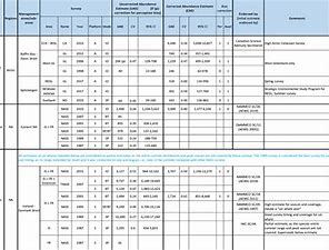
Type of resources
Available actions
Topics
Keywords
Contact for the resource
Provided by
Years
Formats
Representation types
Update frequencies
status
Resolution
-
Assessments run at AFWG provide the scientific basis for the management of cod, haddock, saithe, redfish, Greenland halibut and capelin in subareas 1 and 2. Taking the catch values provided by the Norwegian fisheries ministry for Norwegian catches1 and raising the total landed value to the total catches gives an approximate nominal first-hand landed value for the combined AFWG stocks of ca. 20 billion NOK or ca. 2 billion EUR (2018 estimates).
-

Please note that the contact information included in the report is superseded by the contact information that can be found in the Responsible Parties field of this metadata.This report is a collation of documents and outputs from a variety of plankton monitoring activities conducted on the west, south and east coasts of South Africa and in various parts of the Southern Ocean (during annual relief voyages to South Africa’s Antarctic and sub-Antarctic research bases) over the past financial year 2017/18. It includes pertinent (plankton-related only) sections of scientific Cruise Reports, CPR tow summaries, contributions to the State of the Oceans and Coasts around South Africa 2017 Report Card, contributions (as oral and poster presentations) to scientific conferences, symposia and workshops, and book chapters and scientific papers submitted to peer reviewed journals in various stages of the publication process.It should be noted that in most cases, the samples of plankton (including bacterio- and phytoplankton and micro-, meso- and macro-zooplankton) collected during the cruises listed remain to a large extent to be analysed so that at best only preliminary data can be presented here. For more details, readers are advised to consult the plankton-related contributions to the State of the Oceans and Coasts around South Africa 2017 Report Card (see Section 5), the relevant Books of Abstracts of the plankton-related presentations made at various conferences and symposia listed in Section 6, and the published scientific literature listed in Section 7 of this and subsequent Annual Plankton Reports.
-
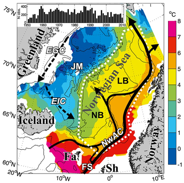
Climate variability in the Norwegian Sea was investigated in terms of ocean heat and freshwater contents of Atlantic water above a reference surface, using hydrographic data during spring 1951–2010. The main processes acting on this variability were examined and then quantified. The area-averaged water mass cooled and freshened, but a deepening of the reference surface resulted in a positive trend in the heat content of 0.3 W m−2. Air-sea heat fluxes explained about half of the interannual variability in heat content. The effect of the advection of Atlantic and Arctic waters on the variability varied with time, apparently due to large-scale changes in the ocean circulation. The data are consistent with the explanation that changing wind patterns caused buffering and then release of Arctic water in the Iceland Sea during the late 1960s to early 1970s, and this caused large hydrographic changes in the Norwegian Sea.
-

Particulate Organic Matter data (stable isotope) for the Integrated Ecosystem Programme: Southern Benguela (IEP:SB): May 2017.IEP:SB focuses on the biologically productive, cold waters of the Benguela Current Large Marine Ecosystem, which are inherently variable on short time-scales and responsive to changing weather patterms. The research aims to provide relevant, reliable and improved assessment of the ecosystem, in support of its effective management, preservation and conservation, so that South Africans can benefit from a healthy and well-functioning ocean environment. The overarching objective is to enhance understanding in process studies by assessing the importance, timing and magnitude of mechanisms and processes that influence the Southern Benguela ecosystem structure and functioning, including the climate variability.
-
Excel file containing CPR data from Standard Areas B4,C3,C4,D3,D4,D5,E4,F4 for the plankton Calanus finmarchicus and helgolandicus, total traverse (small) copepods, total large copepods, Phytoplankton Colour Index and Cnidaria (presence denoted by a 1, absence by a zero). All taxa are from 1980, except Cnidaria which are from 2011. Dataset is in the format of sample level data, with each row being a discrete sample, with a sample being 3m3 filtered seawater, and 10nm of tow. For each row, a sample has the following information, starting at column a: Standard area of sample, sample id, latitude (decimal degrees) of sample mid point, longitude (decimal degrees) of sample midpoint, sample midpoint date and local time, year of sample, month of sample, then plankton abundance values (or PCI index or cnidaria presence/absence). All taxa have been looked for during the period this dataset spans, so zero values represent true absence.
-

Seasonal mean total cumulative upwelling in the Agulhas Bank (33.3-37.5°S;18.5-27°E) shelf region during austral summer, autumn, winter, and spring.
-
This dataset containing traits of marine fish is based on fish taxa observed during international scientific bottom-trawl surveys regularly conducted in the Northeast Atlantic, Northwest Atlantic and the Northeast Pacific. These scientific surveys target primarily demersal (bottom-dwelling) fish species, but pelagic species are also regularly recorded. The overarching aim of this dataset was to collect information on ecological traits for as many fish taxa as possible and to find area-specific trait values to account for intraspecific variation in traits, especially for widely distributed species. We collected traits for species, genera and families. The majority of trait values were sourced from FishBase (Froese and Pauly, 2019), and have been supplemented with values from the primary literature.
-
The purpose of this table is to present the best available abundance estimates for cetacean species in areas of relevance to the work of NAMMCO. It is intended to be used as a starting point for researchers, and the original sources are provided if additional information is required. The Scientific Committee of NAMMCO maintains a Working Group on Abundance Estimates, composed of invited experts in the field as well as some Committee members. This Working Group meets periodically to review new abundance estimates from recent surveys or, in some cases, re-analyses of older data. The reports of the Working Group are brought to the Scientific Committee at their annual meetings, and used to formulate advice on stock status, allowable removals or other matters. In most cases, the Scientific Committee will formally endorse estimates approved by the Working Group, and if so, this is indicated on the Table. Some estimates have been endorsed by the Scientific Committee of the International Whaling Commission (IWC).
-
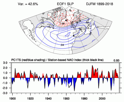
The principal component (PC)-based indices of the North Atlantic Oscillation (NAO) are the time series of the leading Empirical Orthogonal Function (EOF) of SLP anomalies over the Atlantic sector, 20°-80°N, 90°W-40°E. These indices are used to measure the NAO throughout the year, tracking the seasonal movements of the Icelandic low and Azores high. These movements are illustrated in the Figures on this page. Positive values of the NAO index are typically associated with stronger-than-average westerlies over the middle latitudes, more intense weather systems over the North Atlantic and wetter/milder weather over western Europe.
-
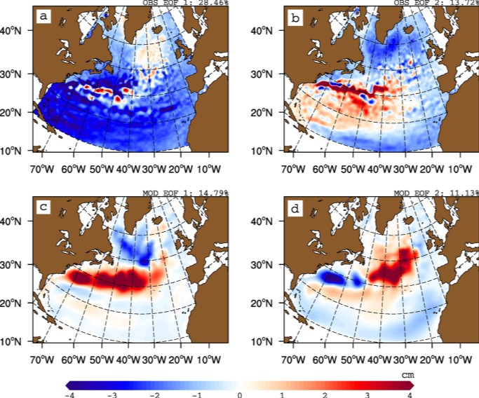
The gyre index constructed here from satellite altimetry is related to core aspects of the North Atlantic subpolar gyre, meridional overturning circulation, hydrographic properties in the Atlantic inflows toward the Arctic, and in marine ecosystems in the northeast Atlantic Ocean. The data series spans the period January 1993 to September 2018. Data description: Monthly gyre index from January 1993 until September 2018. The data is provided in one comma separated value (csv) file with the following entries on each row: year, month, index value. The index is normalized, i.e. it has a zero mean and unit standard deviation. Positive (negative) gyre index reflects stronger (weaker) than average surface circulation of the North Atlantic subpolar gyre.