 Catalogue PIGMA
Environmental monitoring facilities
Type of resources
Available actions
Topics
Keywords
Contact for the resource
Provided by
Years
Formats
Representation types
Update frequencies
status
Scale
Resolution
-
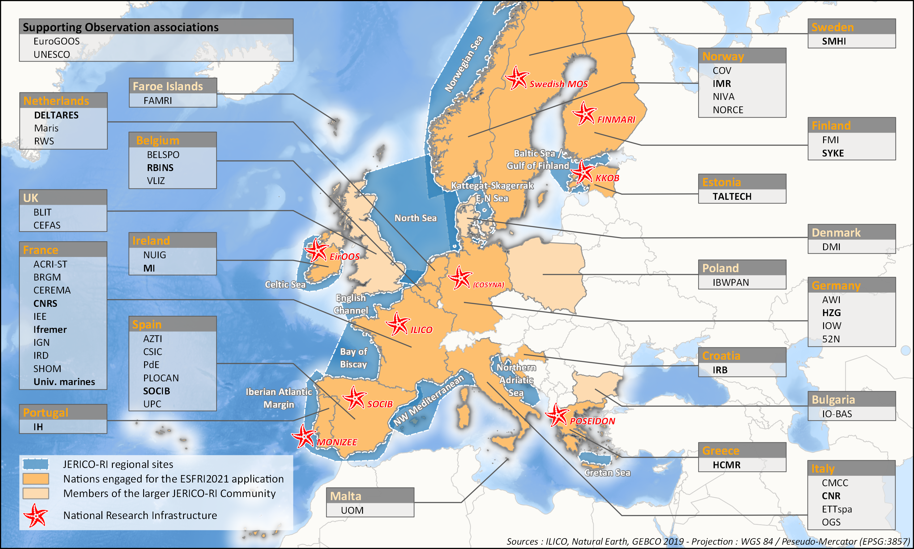
aThis survey action has been undertaken as part of WP6 of the H2020 JERICO-S3 project. Its integration in Sextant is the first step towards a comprehensive and extensive data catalog for the JERICO Research Infrastructure. JERICO-S3, Description of Work - WP6 : Data Management Task 6.2: Data management for coastal platforms (M1-48) (Lead: HCMR) Subtask 6.2.1: Identify and update the overview of JERICO-RI involved platforms and data (SMHI, MARIS, IFREMER) (M1-48) The JERICO dataset catalogue has proven a useful tool for creating an overview of platforms and data relevant for the project this and will be updated. Input from other WP’s will be used to identify the actual JERICO platforms, including the PSS, TNA platforms, and IRS. Partners will collect and describe coastal platforms in the dataset catalogue (technically run in WP7) including pointers to data, which variables (related to EOV’s) published as D6.2. Subtask 6.2.2: Best practice capturing for “mature” platforms with physical and BGC parameters (HCMR, SMHI, CNR, ETT, SOCIB, HZG, RWS) (M6-42). For the following platform types there will be activities supporting data management as defined under T6.4 in close relation to the Virtual Research Environment in WP7: HF radars (CNR), Gliders (SOCIB, ETT), FerryBox (HZG) The work for each platform type will follow basically the same approach and will cooperate with WP4 (PSS) and WP3 (IRS). The experts will identify the existing standards, and possible data management best practices (D6.3). At the end of the project an evaluation will be done of the level of Best Practice adoption at the IRSs and PSSs in the project, as well as the use of the VRE by the partners engaged in WP3 and WP4 (D6.10). This will be done in cooperation with WP3 and WP4, and is an important condition for data to be accessible for use in the Virtual Environment in T7.4.
-
to deliver maps showing the extent of the trawling fishing grounds for identifying the areas which are most disturbed by bottom trawling over the past ten years and identifying the gaps of fishing vessels’ tracking systems in the Mediterranean Sea
-
to deliver maps showing the extent of the trawling fishing grounds for identifying the areas which are most disturbed by bottom trawling over the past ten years and identifying the gaps of fishing vessels’ tracking systems in the Mediterranean Sea
-
to deliver maps showing the extent of the trawling fishing grounds for identifying the changes in level of disturbance over the past ten years and identifying the gaps of fishing vessels’ tracking systems in the Mediterranean Sea
-
The Oil Platform Leaks challenge attempts to determine the likely trajectory of the slick and to release rapid information on the oil movement and environmental and coastal impacts in the form of two impacts bulletins at 24 and 72 hours. Each bulletin indicates what information can be provided, evidencing the fitness for use of the current available marine datasets, as well as pointing out gaps in the current Emodnet data collection framework. This first product relies on an oil spill modelling tool operated by CLS and provide the status of datasets for the purpose of the oil Spill simulation exercice. The OSCAR model (Oil Spill Contingency and Response, operated at CLS under license) made available by SINTEF and used to simulate the oil spill fate and weathering at water surface, in the water column and along shorelines. The declarative data given for the OSCAR simulation are: Date and time of oil spill, Location and depth of oil spill, Oil API number or oil type name, Oil spill amount or oil spill rate
-
to deliver maps showing the extent of the trawling fishing grounds for identifying the changes in level of disturbance over the past ten years and identifying the gaps of fishing vessels’ tracking systems in the Mediterranean Sea
-
to deliver maps showing the extent of the trawling fishing grounds for identifying the areas which are most disturbed by bottom trawling over the past ten years and identifying the gaps of fishing vessels’ tracking systems in the Mediterranean Sea
-
The Oil Platform Leaks challenge attempts to determine the likely trajectory of the slick and to release rapid information on the oil movement and environmental and coastal impacts in the form of a bulletin broadcast 72 hours after the event. This bulletin indicates what information can be provided, evidencing the fitness for use of the current available marine datasets, as well as pointing out gaps in the current Emodnet data collection framework. The exercise relies on two tools operated by CLS: The OSCAR model (Oil Spill Contingency and Response, operated at CLS under license) made available by SINTEF and used to simulate the oil spill fate and weathering at water surface, in the water column and along shorelines. A QGIS system to display and cross the oil spill forecast with coastal data (information on environment and human activities). The declarative data given for the OSCAR simulation are: Date and time of oil spill, Location and depth of oil spill, Oil API number or oil type name, Oil spill amount or oil spill rate
-
Temporal series (annual mean values) and Long term Average (LTA) of water discharge for each river mouth where in situ data is available. Different sources can be mixed if any.
-
The Oil Platform Leaks challenge attempts to determine the likely trajectory of the slick and to release rapid information on the oil movement and environmental and coastal impacts in the form of a bulletin at 24 hours from the event. This bulletin indicates what information can be provided, evidencing the fitness for use of the current available marine datasets, as well as pointing out gaps in the current Emodnet data collection framework. This first product relies on an oil spill modelling tool operated by CLS and provide the status of datasets for the purpose of the oil Spill simulation exercice. The OSCAR model (Oil Spill Contingency and Response, operated at CLS under license) made available by SINTEF and used to simulate the oil spill fate and weathering at water surface, in the water column and along shorelines. The declarative data given for the OSCAR simulation are: Date and time of oil spill, Location and depth of oil spill, Oil API number or oil type name, Oil spill amount or oil spill rate