 Catalogue PIGMA
CDS-IS-CORIOLIS
Type of resources
Available actions
Topics
Keywords
Contact for the resource
Provided by
Years
Formats
Representation types
Update frequencies
status
Scale
-
X : eXpendable; B : Bathy; T: Thermograph. Thermal profile measurement with real-time transmission
-

GOSUD aims at assembling in-situ observations of the world ocean surface collected by a variety of ships and at distributing quality controlled datasets. At present time the variables considered by GOSUD are temperature and salinity. The GOSUD data are mostly collected using thermosalinographs (TSG) installed on research vessels, on commercial ships and in some cases on sailing exploration ships. GOSUD manages both near-real time (RT and NRT) data and delayed mode (DM-reprocessed) data. The GOSUD GDAC is hosted by the Coriolis data centre (France) and a back-up (permanent archived) is performed on a daily basis by NCEIS (NOAA's National Centers for Environmental Information).
-
ARVOR-C is a subsurface profiling float designed to operate in coastal environments and to perform oceanographic measurements like a moored installation. Its design has been improved to reduce its drift thanks to a seabed claw and anti-drift claws, an optimized profile speed (~ 25 cm / s) and a short-period data transmission. It is able to process more than 300 profiles and real-time data transmission via Iridium satellite system.
-
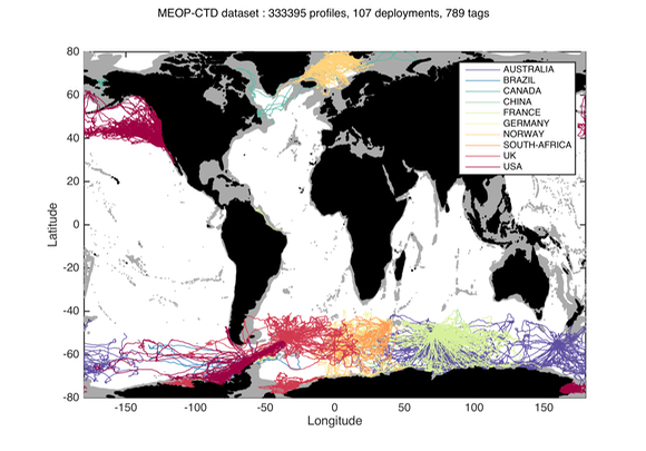
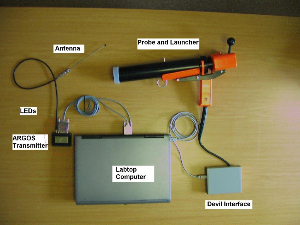
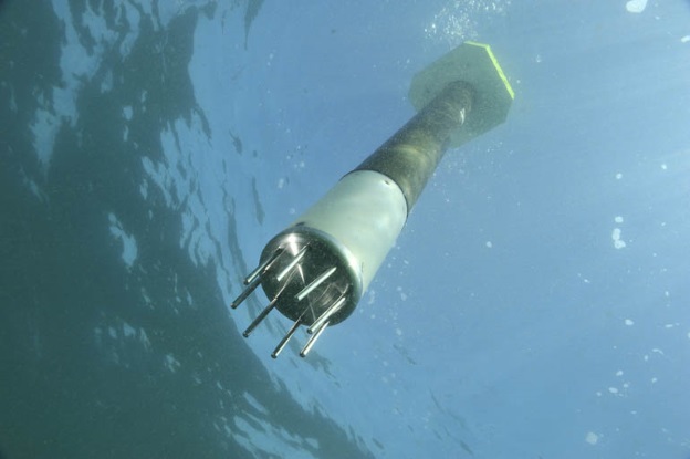
Since 2004, several hundred seals have been equipped with conductivity-temperature-depth (CTD) sensors in the Southern Ocean for both biological and physical oceanographic studies. A calibrated collection of seal-derived hydrographic data is now available from Coriolis, currently consisting of more than 300,000 temperature/salinity profiles. Delayed mode data, December 2014 http://dx.doi.org/10.12770/0a82d60c-683d-47b8-8bd1-24933ec24983 on the Coriolis ftp server, in /ifremer/marine_mammals/. In a near future (summer 2015), seal data will be updated daily, and a monthly snapshot of the full database will be produced. through the Coriolis data selection tool (Sea mammal or Animal profiles).
-
Observation of surface currents by HF radars. This system of HF radars makes it possible to compile, continuously and over long periods, maps of surface marine currents, up to 100km and with a spatial resolution of 3km.
-
The Drifting Buoys GDAC -Global Data Assembly Centre- is the repository of surface drifters data. Both NRT -Near Real Time- and DM -Delayed Mode- data are available on the GDAC. Drifters report generally trajectories, sea-surface temperatures, atmospheric pressures at sea-level, as well as sea-surface salinity or sub-surface temperature in the ocean top layer.
-
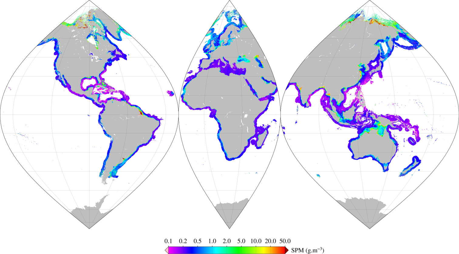
Monthly mean of Suspended Particulate Matter (2002-2012) using Han (2016) algorithm for coastal areas, at global scale, for MERIS sensor, with POLYMER atmospheric corrections. Ref: Bing Han, Hubert Loisel, Vincent Vantrepotte, Xavier Mériaux, Philippe Bryère,Sylvain Ouillon, David Dessailly, Qianguo Xing and Jianhua Zhu. Development of a Semi-Analytical Algorithm for the Retrieval of Suspended Particulate Matter rom Remote Sensing over Clear to Very Turbid Waters Remote Sens. 8, 211; doi:10.3390/rs8030211 2016
-
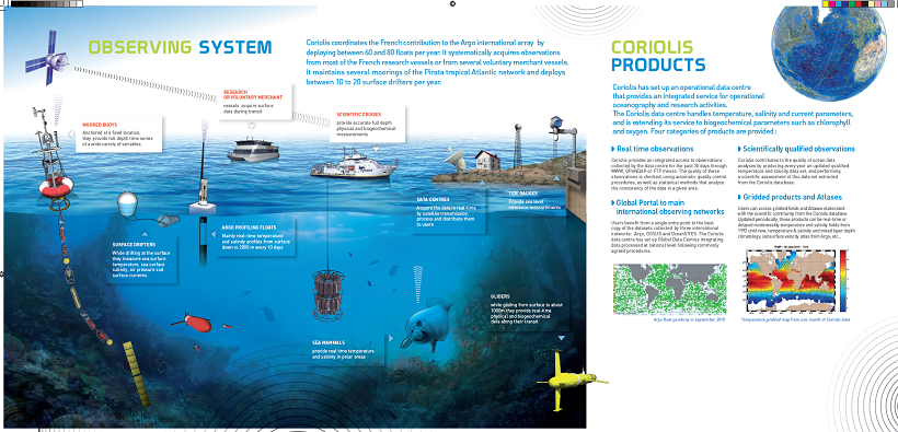
The CORIOLIS data center contributes to the “in situ observations” of operational oceanography, in addition to ocean surface measurements performed using equipment installed on satellites. This contribution is accomplished through the creation of permanent and lasting networks from ships or moored or drifting autonomous systems.
-
Description of the National Center for Archiving Swell Measurements (CANDHIS).
-
The mission of OceanSITES is to collect, deliver and promote the use of high-quality data from long-term, high-frequency observations at fixed locations in the open ocean. OceanSITES typically aim to collect multidisciplinary data worldwide from the full-depth water column as well as the overlying atmosphere. OceanSITES delivers high-quality data from long-term, high-frequency observations at fixed locations in the open ocean.